

Etowah River
Encyclopedia
Dahlonega, Georgia
Dahlonega is a city in Lumpkin County, Georgia, United States, and is its county seat. As of the 2010 census, the city had a population of 5,242....
, Georgia
Georgia (U.S. state)
Georgia is a state located in the southeastern United States. It was established in 1732, the last of the original Thirteen Colonies. The state is named after King George II of Great Britain. Georgia was the fourth state to ratify the United States Constitution, on January 2, 1788...
, north of Atlanta. Its name is the Cherokee
Cherokee language
Cherokee is an Iroquoian language spoken by the Cherokee people which uses a unique syllabary writing system. It is the only Southern Iroquoian language that remains spoken. Cherokee is a polysynthetic language.-North American etymology:...
version of the original Muskogee
Creek language
The Creek language, also known as Muskogee or Muscogee , is a Muskogean language spoken by Muscogee and Seminole people primarily in the U.S. states of Oklahoma and Florida....
word Etalwa, which means a "trail crossing". On Matthew Carey's 1795 map the river was labeled "High Town River". On later maps, such as the 1839 Cass County map, it was referred to as "Hightower River", a name that was used in most early Cherokee records.
The large Amicalola Creek (which flows over Amicalola Falls
Amicalola Falls
Amicalola Falls is a 729-foot waterfall in Dawson County, Georgia, USA. It the highest waterfall in Georgia and is considered to be one of the Seven Natural Wonders of Georgia. The name "Amicalola" is derived from a Cherokee language word meaning "tumbling waters."" It is located within...
) is a primary tributary
Tributary
A tributary or affluent is a stream or river that flows into a main stem river or a lake. A tributary does not flow directly into a sea or ocean...
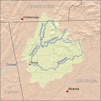
near the beginning of the river. The Etowah then flows west-southwest through Canton, Georgia
Canton, Georgia
Canton is a city in and the county seat of Cherokee County, Georgia, United States. As of the 2010 census, the city had a population of 22,958.-Geography:Canton is located at ....
, and soon forms Lake Allatoona
Lake Allatoona
Lake Allatoona is a U.S. Army Corps of Engineers reservoir in Georgia, located in northwestern metro Atlanta. The lake is mostly in southwestern Cherokee County, but a significant part is in southeastern Bartow County, and a small part in Cobb County near Acworth. Cartersville is the nearest...
. From the dam at the lake, it passes Cartersville
Cartersville, Georgia
Cartersville is a town in Bartow County, in the U.S. state of Georgia. As of the 2010 census, the city had a population of 19,7314. The city is the county seat of Bartow County.-Geography:Cartersville was named for Colonel Farish Carter....
and the Etowah Indian Mounds
Etowah Indian Mounds
Etowah Indian Mounds is a archaeological site in Bartow County, Georgia south of Cartersville, in the United States. Built and occupied in three phases, from 1000–1550 CE, the prehistoric site is located on the north shore of the Etowah River. Etowah Indian Mounds Historic Site is a designated...
archaeological site. It then flows to Rome, Georgia
Rome, Georgia
Located in the foothills of the Appalachian Mountains, Rome is the largest city and the county seat of Floyd County, Georgia, United States. It is the principal city of the Rome, Georgia Metropolitan Statistical Area which encompasses all of Floyd County...
, where it meets the Oostanaula River
Oostanaula River
The Oostanaula River is a principal tributary of the Coosa River, about long, in northwestern Georgia in the United States. Via the Coosa and Alabama rivers, it is part of the watershed of the Mobile River, which flows to the Gulf of Mexico. Its name is said to come from a Cherokee Indian term...
and forms the Coosa River
Coosa River
The Coosa River is a tributary of the Alabama River in the U.S. states of Alabama and Georgia. The river is about long altogether.The Coosa River is one of Alabama's most developed rivers...
at their confluence
Confluence
Confluence, in geography, describes the meeting of two or more bodies of water.Confluence may also refer to:* Confluence , a property of term rewriting systems...
. The river is the northernmost portion of the Etowah-Coosa-Alabama-Mobile Waterway, stretching from the mountains of north Georgia to Mobile Bay
Mobile Bay
Mobile Bay is an inlet of the Gulf of Mexico, lying within the state of Alabama in the United States. Its mouth is formed by the Fort Morgan Peninsula on the eastern side and Dauphin Island, a barrier island on the western side. The Mobile River and Tensaw River empty into the northern end of the...
in Alabama
Alabama
Alabama is a state located in the southeastern region of the United States. It is bordered by Tennessee to the north, Georgia to the east, Florida and the Gulf of Mexico to the south, and Mississippi to the west. Alabama ranks 30th in total land area and ranks second in the size of its inland...
.
The Little River
Little River (northern Georgia)
The Little River is a tributary of the Etowah River in the U.S. state of Georgia in the United States.The Little River is located mostly in Cherokee County, and forms the jagged part of the Cherokee/Fulton county line, and part of the more recent Milton city limit.The river flows generally from...
is the largest tributary of the Etowah, their confluence now flooded by Lake Allatoona. Allatoona Creek is another major tributary, flowing north from Cobb County
Cobb County, Georgia
Cobb County is a county located in the U.S. state of Georgia. Its county seat and largest city is Marietta, which is located in the center of the county. The county was named for Thomas Willis Cobb, who in the early 19th century was a United States representative and senator from Georgia...
and forming the other major arm of the lake.
The U.S. Board on Geographic Names officially named the river in 1897.
The river ends at 571 feet or 174 meters above mean sea level
Above mean sea level
The term above mean sea level refers to the elevation or altitude of any object, relative to the average sea level datum. AMSL is used extensively in radio by engineers to determine the coverage area a station will be able to reach...
.
The river is home to the Etowah Darter
Etheostoma
Etheostoma is a diverse genus of small freshwater fish in the family Percidae. It contains nearly 140 member species. Most are native to North America. They are commonly known as darters although the term "darter" is shared by several other genera...
, which is listed on the Endangered Species List
IUCN Red List
The IUCN Red List of Threatened Species , founded in 1963, is the world's most comprehensive inventory of the global conservation status of biological species. The International Union for Conservation of Nature is the world's main authority on the conservation status of species...
.
Tributaries
- AcworthAcworth, GeorgiaAcworth is a city in Cobb County, Georgia, United States. As of the 2010 census, the city had a population of 20,425. Acworth is located in the foothills of the North Georgia mountains along the southeastern banks of Lake Acworth and Lake Allatoona on the Etowah River.Acworth's nickname is "The...
Creek - Allatoona Creek
- Amicalola River
- Big Dry Creek
- Boston Creek
- Butler Creek
- Cane Creek
- CantonCanton, GeorgiaCanton is a city in and the county seat of Cherokee County, Georgia, United States. As of the 2010 census, the city had a population of 22,958.-Geography:Canton is located at ....
Creek - Clark Creek
- Downing Creek
- Dykes Creek
- Euharlee CreekEuharlee CreekEuharlee Creek is a 21-mile-long waterway which traverses across two counties in Georgia, Bartow County and Polk County. It begins in Polk County, GA near the city of Rockmart, GA and joins the Etowah River in Euharlee, GA. The historic Euharlee Covered Bridge spans across Euharlee Creek....
- Hall Creek
- Hickory Log CreekHickory Log CreekHickory Log Creek Dam is a gravity dam on the Hickory Log Creek which runs from northeast and north-central Cherokee County, Georgia, south-southwest to the northeastern part of Canton, the county seat...
- Illinois Creek
- Kellogg Creek
- Little Allatoona Creek
- Little River
- Long Swamp Creek
- McKaskey Creek
- Noonday Creek
- Owl Creek
- Petit Creek
- Proctor Creek
- Pumpkinvine Creek
- Raccoon Creek (Georgia, U.S.)Raccoon Creek (Georgia, U.S.)Raccoon Creek is a 21-mile-long waterway which traverses through two counties in Georgia, U.S., beginning in Paulding County and joining the Etowah River in Bartow County. The waterway begins near the town of Yorkville, Georgia and ends near the town Stilesboro, Georgia....
- Rocky Creek
- Rubes Creek
- Shoal Creek
- SixesSixes, GeorgiaSixes is an unincorporated community in western Cherokee County, Georgia, United States, located about three miles west of Holly Springs and near the eastern shore of current-day Lake Allatoona. The community is located in the Georgia Gold Belt, which runs southwest to northeast along the southern...
Creek - Settin Down Creek
- Stamp Creek
- Tanyard Creek
Places
- Lumpkin County, GeorgiaLumpkin County, GeorgiaLumpkin County is a county located in the U.S. state of Georgia. As of the 2010 census, the population was 29,966. Its county seat is Dahlonega.- History :...
- DahlonegaDahlonega, GeorgiaDahlonega is a city in Lumpkin County, Georgia, United States, and is its county seat. As of the 2010 census, the city had a population of 5,242....
- Dahlonega
- Dawson County, GeorgiaDawson County, GeorgiaDawson County is a county located in the U.S. state of Georgia. It was created on December 3, 1857 from Gilmer and Lumpkin counties. As of 2000, the population is 15,999. The 2007 Census Estimate showed a population of 21,484...
- DawsonvilleDawsonville, GeorgiaDawsonville is a city in Dawson County, Georgia, United States. The population was 619 at the 2000 census. The city is the county seat of Dawson County...
- Dawsonville
- Forsyth County, GeorgiaForsyth County, GeorgiaForsyth County is a county located in the U.S. state of Georgia. The county seat is Cumming, Georgia. Forsyth County is a part of the Atlanta metropolitan area...
- Cherokee County, GeorgiaCherokee County, GeorgiaAs of the census of 2000, there were 141,903 people, 49,495 households, and 39,200 families residing in the county. The population density was 335 people per square mile . There were 51,937 housing units at an average density of 123 per square mile...
- CantonCanton, GeorgiaCanton is a city in and the county seat of Cherokee County, Georgia, United States. As of the 2010 census, the city had a population of 22,958.-Geography:Canton is located at ....
- Canton
- Bartow County, GeorgiaBartow County, GeorgiaBartow County is a county located in the U.S. state of Georgia. As of the 2010 census, the population was 100,157. According to the U.S. Census Bureau's July 1, 2009 estimate, the county's explosive growth resulted in a population of 96,217, a 26.5% increase in less than ten years...
- CartersvilleCartersville, GeorgiaCartersville is a town in Bartow County, in the U.S. state of Georgia. As of the 2010 census, the city had a population of 19,7314. The city is the county seat of Bartow County.-Geography:Cartersville was named for Colonel Farish Carter....
- Cartersville
- Floyd County, GeorgiaFloyd County, GeorgiaFloyd County is a county located in the U.S. state of Georgia. As of 2000, the population was 90,565. Census estimates for 2007 show a population of 95,618...
- RomeRome, GeorgiaLocated in the foothills of the Appalachian Mountains, Rome is the largest city and the county seat of Floyd County, Georgia, United States. It is the principal city of the Rome, Georgia Metropolitan Statistical Area which encompasses all of Floyd County...
- Rome