
.gif)
Hurricane Gordon (2006)
Encyclopedia
Hurricane Gordon was the first tropical cyclone
since 1992 to affect the Azores
while retaining
tropical characteristics. The eighth tropical storm, third hurricane, and first major hurricane of the 2006 Atlantic hurricane season
, Gordon formed on September 10 in the tropical Atlantic Ocean. It gradually matured into a hurricane as it tracked northward, reaching its peak intensity with winds of 120 mph (195 km/h) early on September 14 while located about 575 mi (925.4 km) southeast of Bermuda
. After becoming nearly stationary, Gordon weakened to minimal hurricane status, although it re-intensified after accelerating to the east. It weakened again after moving over cooler waters, and passed through the Azores on September 20. Shortly thereafter, it became an extratropical cyclone
and subsequently affected Spain, Ireland, and the United Kingdom.
The only land area affected while Gordon was tropical – the Azores – sustained little damage, in spite of wind gusts reaching hurricane force on Santa Maria Island
. Impact was much more significant from the storm in its extratropical phase. In Spain, wind gusts reached 114 mph (183.5 km/h) along the northwest coast and left 100,000 people without power. Five people in the country sustained storm-related injuries. Further north, the storm brought a surge of tropical air to Ireland and the United Kingdom, contributing to record warm temperatures. In Northern Ireland
, high winds left 120,000 people without power and caused one injury.
exited the west coast of Africa and quickly showed signs of organization. It possessed a low pressure area
and some convection as the system moved generally westward. The National Hurricane Center
(NHC) first pinpointed the system as an area for potential development late on September 2 while it was about 750 mi (1,207 km) west-southwest of Cape Verde
. However, an upper-level trough
associated with the developing Hurricane Florence
to its west increased wind shear
across the region, which prevented significant tropical cyclone development
over the next week. However, on September 5, the NHC noted the potential for the storm system to organize into a tropical depression within the next several days, but its close proximity to Florence continued to stall its strengthening. By September 9, the trough moved far enough away from the system to allow wind shear to relent, signalling an increase in convective thunderstorm activity. At around 1800 UTC
that day, the system developed into a tropical depression about 540 mi (869 km) east-northeast of the Lesser Antilles
.
Upon developing, the depression, small in physical size, moved slowly west-northwestward. Initially, the NHC faced difficulties in forecasting the future of the system due to the potential for resumed strong wind shear, as well as uncertainty in its path of direction. It gradually organized and intensified, and based on observations from the Hurricane Hunters
, the NHC assessed the depression as a tropical storm late on September 11; upon doing so, they gave it the name
Gordon. As it strengthened, Gordon developed more substantial outflow
and increasing banding features. On September 12, the storm slowed and turned toward the north through a weakness in the subtropical ridge
created by Florence. Wind shear decreased further, and the storm's convection became more symmetric with an intermittent eye feature
in the center. Based on the presence of the eye and estimates from satellite imagery, it is estimated that Gordon intensified into a hurricane early on September 13.
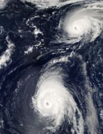
After becoming a hurricane, Gordon underwent rapid deepening
as the eye became better defined and more intense. In 24 hours, the winds increased by 45 mph (72.4 km/h) to a peak intensity of 120 mph (195 km/h) early on September 14, while located about 575 mi (925.4 km) southeast of Bermuda
. This made Gordon a major hurricane, as well as a Category 3 on the Saffir-Simpson scale
, the first of 2006. As it curved to the northeast, the hurricane maintained its peak intensity for about 24 hours, during which the eye decreased in size and the eyewall convection weakened. Afterward, Gordon began weakening due to moving over an area of cooler water temperatures. On September 15, the trough that was previously guiding the hurricane moved further away, allowing the ridge to build to the north and causing Gordon's motion to become nearly stationary. Increased wind shear imparted further weakening, and the hurricane's slow motion resulted in upwelling
– the motion of cooler water to the ocean's surface. On September 17, a building ridge to the east caused Gordon to begin a steady northeast motion. By that time, the convection had diminished significantly and the winds weakened to minimal hurricane-force. One NHC forecast predicted extratropical transition
to occur within 48 hours.
 On September 18, Hurricane Gordon began accelerating to the northeast around a strengthening ridge, and later toward the east as guided by a trough. Wind shear decreased, which allowed for convection to redevelop near the eye. Unexpectedly, the hurricane began restrengthening, despite moving over slightly cooler waters; instability from cooler upper-level temperatures allowed for the reintensification. Despite continued forecasts of a weakening trend, Gordon's resiliency presented a rare threat – the first since Hurricane Charley
in 1992 – to the Azores, a Portuguese
archipelago
in the northeast Atlantic Ocean. At about 0600 UTC on September 19, the hurricane attained its secondary peak intensity of 105 mph (169 km/h) about 485 mi (775 km) west-southwest of the Azores. By that time, the cyclone consisted of a solid ring of convection around a contracting eye. Shortly thereafter, Gordon began steadily weakening due to the combination of increasing wind shear and even cooler water temperatures. Its motion became just south of due east, causing the strongest winds to remain south of the islands. At around 0900 UTC on September 20, Gordon passed through the Azores between the islands of Santa Maria and São Miguel
, producing hurricane-force wind gusts on the former island. At the time, its sustained winds were estimated around 75 mph (120.7 km/h), which remained south of any landmasses. The cloud pattern had become less organized and more ragged.
 After passing the Azores, Gordon began interacting with an approaching cold front. Early on September 21, it completed the transition into an extratropical storm while simultaneously weakening below hurricane-force, located about 275 mi (442.6 km) west-northwest of the west coast of Portugal
. The cyclone maintained its identity as the system turned sharply northeastward and later northward, after passing about 100 mi (160 km) northwest of the Spanish
province of Galicia. Its forward motion accelerated to about 60 mph (96.6 km/h), steered by another extratropical storm, while still maintaining sustained winds of 65 mph (104.6 km/h). After moving along the west coast of Ireland
, the extratropical remnants of Gordon turned to the northwest and intensified to hurricane-force winds. It turned to the southwest and later to the southeast, completing a large cyclonic loop before dissipating on September 24 to the south of Ireland.
was issued for all of the Azores. The hurricane was expected to weaken to tropical storm-force before affecting the islands. When it became apparent that Gordon would continue intensifying, a hurricane warning replaced the watch about 27 hours before the strongest winds affected the region. The advance of the storm forced the closure of all schools in the region. Concurrently, officials increased the number of emergency workers on stand-by. The two westernmost islands – Corvo
and Flores – were placed under a red alert, the highest on a four-level scale, which indicated the greatest threat for severe weather. The remainder of the archipelago was placed on low alert. Ultimately, the Azores escaped significant damage as the hurricane passed farther south than expected. Overall impact was limited to toppled trees and power lines, leaving portions of Santa Maria Island without electrical service. Santa Maria recorded sustained winds of 56 mph (90.1 km/h), with gusts to 82 mph (132 km/h).
In Portugal, coastal regions were put under a yellow alert, the second lowest level, since the extratropical remnants of Gordon were expected to produce rough seas and heavy rains. In Spain, the Galicia region was placed on red alert by authorities in anticipation of the storm. Classes on September 21 were also suspended by the regional education ministry. Eleven other regions of Spain, extending as far east as Madrid
and as far south as Andalusia
, received lower levels of warning. The storm's threat also prompted the cancellation or delay of flights along the coast. While passing northwest of Spain, the remnants of Gordon produced strong wind gusts, reaching 114 mph (183.5 km/h) at Punta Candieira in Galicia on the country's northwest coast. The nearby city of A Coruña
recorded sustained winds of 43 mph (69.2 km/h), while further inland, a station near Madrid reported winds of 65 mph (107 km/h). Along the coast, waves reached 23 ft (7 m) in height, while rainbands dropped heavy precipitation, including a total of 2.58 in (65.5 mm) in Canfranc
. Wind-blown debris injured four people in the country, and a fifth storm-related injury occurred as the result of a tree falling onto an occupied vehicle. The winds downed trees, traffic lights, and power lines, leaving about 100,000 people without power. Throughout Galicia, total monetary losses reached €
3 million (US$
3.8 million; 2006 USD).
Stormy conditions threatened to affect the 2006 Ryder Cup
in Straffan
, County Kildare
, Ireland
at the K Club, and September 25 was set aside as an additional "reserve day". The club's media center was briefly evacuated, and one woman at the event was injured after being struck by a tree branch broken by the storm. The remnants of Gordon caused stormy conditions that left at least 5,000 people without power in eastern and southern Ireland. One electric company had over 400 workers on duty to restore power in affected areas. High winds blowing down trees were responsible for power outages which affected 126,000 people in Northern Ireland
.
The remnants of Gordon affected the United Kingdom with strong winds, including gusts to 60 mph (96.6 km/h) in the Isles of Scilly
off the southwest coast and 81 mph (130.4 km/h) on the mainland. The storm system produced heavy precipitation and thunderstorms that caused localized flooding. Wainfleet, Lincolnshire
recorded 1.66 in (42.2 mm) of rainfall, of which almost half fell within the span of an hour. High winds delayed rail service, and in Dawlish
, the rail line was damaged by coastal flooding. More than 1,000 homes were left without power in Truro
, Cornwall
. The storm brought moist air northward that contributed to record warm temperatures across portions of the UK.
Tropical cyclone
A tropical cyclone is a storm system characterized by a large low-pressure center and numerous thunderstorms that produce strong winds and heavy rain. Tropical cyclones strengthen when water evaporated from the ocean is released as the saturated air rises, resulting in condensation of water vapor...
since 1992 to affect the Azores
Azores
The Archipelago of the Azores is composed of nine volcanic islands situated in the middle of the North Atlantic Ocean, and is located about west from Lisbon and about east from the east coast of North America. The islands, and their economic exclusion zone, form the Autonomous Region of the...
while retaining
Extratropical cyclone
Extratropical cyclones, sometimes called mid-latitude cyclones or wave cyclones, are a group of cyclones defined as synoptic scale low pressure weather systems that occur in the middle latitudes of the Earth having neither tropical nor polar characteristics, and are connected with fronts and...
tropical characteristics. The eighth tropical storm, third hurricane, and first major hurricane of the 2006 Atlantic hurricane season
2006 Atlantic hurricane season
The 2006 Atlantic hurricane season was significantly less active than the record previous season. It marked the first since 2001 in which no hurricanes made landfall in the United States, and was the first since 1994 that no tropical cyclones formed during October. Following the intense activity of...
, Gordon formed on September 10 in the tropical Atlantic Ocean. It gradually matured into a hurricane as it tracked northward, reaching its peak intensity with winds of 120 mph (195 km/h) early on September 14 while located about 575 mi (925.4 km) southeast of Bermuda
Bermuda
Bermuda is a British overseas territory in the North Atlantic Ocean. Located off the east coast of the United States, its nearest landmass is Cape Hatteras, North Carolina, about to the west-northwest. It is about south of Halifax, Nova Scotia, Canada, and northeast of Miami, Florida...
. After becoming nearly stationary, Gordon weakened to minimal hurricane status, although it re-intensified after accelerating to the east. It weakened again after moving over cooler waters, and passed through the Azores on September 20. Shortly thereafter, it became an extratropical cyclone
Extratropical cyclone
Extratropical cyclones, sometimes called mid-latitude cyclones or wave cyclones, are a group of cyclones defined as synoptic scale low pressure weather systems that occur in the middle latitudes of the Earth having neither tropical nor polar characteristics, and are connected with fronts and...
and subsequently affected Spain, Ireland, and the United Kingdom.
The only land area affected while Gordon was tropical – the Azores – sustained little damage, in spite of wind gusts reaching hurricane force on Santa Maria Island
Santa Maria Island
Santa Maria , Portuguese for Saint Mary, is an island located in the eastern group of the Azores archipelago and the southernmost island in the Azores...
. Impact was much more significant from the storm in its extratropical phase. In Spain, wind gusts reached 114 mph (183.5 km/h) along the northwest coast and left 100,000 people without power. Five people in the country sustained storm-related injuries. Further north, the storm brought a surge of tropical air to Ireland and the United Kingdom, contributing to record warm temperatures. In Northern Ireland
Northern Ireland
Northern Ireland is one of the four countries of the United Kingdom. Situated in the north-east of the island of Ireland, it shares a border with the Republic of Ireland to the south and west...
, high winds left 120,000 people without power and caused one injury.
Meteorological history
On September 1, a tropical waveTropical wave
Tropical waves, easterly waves, or tropical easterly waves, also known as African easterly waves in the Atlantic region, are a type of atmospheric trough, an elongated area of relatively low air pressure, oriented north to south, which move from east to west across the tropics causing areas of...
exited the west coast of Africa and quickly showed signs of organization. It possessed a low pressure area
Low pressure area
A low-pressure area, or "low", is a region where the atmospheric pressure at sea level is below that of surrounding locations. Low-pressure systems form under areas of wind divergence which occur in upper levels of the troposphere. The formation process of a low-pressure area is known as...
and some convection as the system moved generally westward. The National Hurricane Center
National Hurricane Center
The National Hurricane Center , located at Florida International University in Miami, Florida, is the division of the National Weather Service responsible for tracking and predicting weather systems within the tropics between the Prime Meridian and the 140th meridian west poleward to the 30th...
(NHC) first pinpointed the system as an area for potential development late on September 2 while it was about 750 mi (1,207 km) west-southwest of Cape Verde
Cape Verde
The Republic of Cape Verde is an island country, spanning an archipelago of 10 islands located in the central Atlantic Ocean, 570 kilometres off the coast of Western Africa...
. However, an upper-level trough
Trough (meteorology)
A trough is an elongated region of relatively low atmospheric pressure, often associated with fronts.Unlike fronts, there is not a universal symbol for a trough on a weather chart. The weather charts in some countries or regions mark troughs by a line. In the United States, a trough may be marked...
associated with the developing Hurricane Florence
Hurricane Florence (2006)
Hurricane Florence was the first Atlantic hurricane to produce hurricane force winds on Bermuda since Hurricane Fabian hit the island in September 2003. The seventh tropical storm and second hurricane of the 2006 Atlantic hurricane season, Florence developed from a tropical wave in the tropical...
to its west increased wind shear
Wind shear
Wind shear, sometimes referred to as windshear or wind gradient, is a difference in wind speed and direction over a relatively short distance in the atmosphere...
across the region, which prevented significant tropical cyclone development
Tropical cyclogenesis
Tropical cyclogenesis is the term that describes the development and strengthening of a tropical cyclone in the atmosphere. The mechanisms through which tropical cyclogenesis occurs are distinctly different from those through which mid-latitude cyclogenesis occurs...
over the next week. However, on September 5, the NHC noted the potential for the storm system to organize into a tropical depression within the next several days, but its close proximity to Florence continued to stall its strengthening. By September 9, the trough moved far enough away from the system to allow wind shear to relent, signalling an increase in convective thunderstorm activity. At around 1800 UTC
Coordinated Universal Time
Coordinated Universal Time is the primary time standard by which the world regulates clocks and time. It is one of several closely related successors to Greenwich Mean Time. Computer servers, online services and other entities that rely on having a universally accepted time use UTC for that purpose...
that day, the system developed into a tropical depression about 540 mi (869 km) east-northeast of the Lesser Antilles
Lesser Antilles
The Lesser Antilles are a long, partly volcanic island arc in the Western Hemisphere. Most of its islands form the eastern boundary of the Caribbean Sea with the Atlantic Ocean, with the remainder located in the southern Caribbean just north of South America...
.
Upon developing, the depression, small in physical size, moved slowly west-northwestward. Initially, the NHC faced difficulties in forecasting the future of the system due to the potential for resumed strong wind shear, as well as uncertainty in its path of direction. It gradually organized and intensified, and based on observations from the Hurricane Hunters
Hurricane Hunters
The Hurricane Hunters are aircraft that fly into tropical cyclones in the North Atlantic Ocean and Northeastern Pacific Ocean for the specific purpose of directly measuring weather data in and around those storms. In the United States, the Air Force, Navy, and NOAA units have all participated in...
, the NHC assessed the depression as a tropical storm late on September 11; upon doing so, they gave it the name
Tropical cyclone naming
Tropical cyclones have officially been named since 1945 and are named for a variety of reasons, which include to facilitate communications between forecasters and the public when forecasts, watches, and warnings are issued. Names also reduce confusion about what storm is being described, as more...
Gordon. As it strengthened, Gordon developed more substantial outflow
Outflow (meteorology)
Outflow, in meteorology, is air that flows outwards from a storm system. It is associated with ridging, or anticyclonic flow. In the low levels of the troposphere, outflow radiates from thunderstorms in the form of a wedge of rain-cooled air, which is visible as a thin rope-like cloud on weather...
and increasing banding features. On September 12, the storm slowed and turned toward the north through a weakness in the subtropical ridge
Subtropical ridge
The subtropical ridge is a significant belt of high pressure situated around the latitudes of 30°N in the Northern Hemisphere and 30°S in the Southern Hemisphere. It is characterized by mostly calm winds, which acts to reduce air quality under its axis by causing fog overnight, and haze during...
created by Florence. Wind shear decreased further, and the storm's convection became more symmetric with an intermittent eye feature
Eye (cyclone)
The eye is a region of mostly calm weather found at the center of strong tropical cyclones. The eye of a storm is a roughly circular area and typically 30–65 km in diameter. It is surrounded by the eyewall, a ring of towering thunderstorms where the second most severe weather of a cyclone...
in the center. Based on the presence of the eye and estimates from satellite imagery, it is estimated that Gordon intensified into a hurricane early on September 13.
After becoming a hurricane, Gordon underwent rapid deepening
Rapid deepening
Rapid deepening, also known as rapid intensification, is a meteorological condition that occurs when the minimum sea-level atmospheric pressure of a tropical cyclone decreases drastically in a short period of time. The National Weather Service describes rapid deepening as a decrease of...
as the eye became better defined and more intense. In 24 hours, the winds increased by 45 mph (72.4 km/h) to a peak intensity of 120 mph (195 km/h) early on September 14, while located about 575 mi (925.4 km) southeast of Bermuda
Bermuda
Bermuda is a British overseas territory in the North Atlantic Ocean. Located off the east coast of the United States, its nearest landmass is Cape Hatteras, North Carolina, about to the west-northwest. It is about south of Halifax, Nova Scotia, Canada, and northeast of Miami, Florida...
. This made Gordon a major hurricane, as well as a Category 3 on the Saffir-Simpson scale
Saffir-Simpson Hurricane Scale
The Saffir–Simpson Hurricane Scale , or the Saffir–Simpson Hurricane Wind Scale , classifies hurricanes — Western Hemisphere tropical cyclones that exceed the intensities of tropical depressions and tropical storms — into five categories distinguished by the intensities of their sustained winds...
, the first of 2006. As it curved to the northeast, the hurricane maintained its peak intensity for about 24 hours, during which the eye decreased in size and the eyewall convection weakened. Afterward, Gordon began weakening due to moving over an area of cooler water temperatures. On September 15, the trough that was previously guiding the hurricane moved further away, allowing the ridge to build to the north and causing Gordon's motion to become nearly stationary. Increased wind shear imparted further weakening, and the hurricane's slow motion resulted in upwelling
Upwelling
Upwelling is an oceanographic phenomenon that involves wind-driven motion of dense, cooler, and usually nutrient-rich water towards the ocean surface, replacing the warmer, usually nutrient-depleted surface water. The increased availability in upwelling regions results in high levels of primary...
– the motion of cooler water to the ocean's surface. On September 17, a building ridge to the east caused Gordon to begin a steady northeast motion. By that time, the convection had diminished significantly and the winds weakened to minimal hurricane-force. One NHC forecast predicted extratropical transition
Extratropical cyclone
Extratropical cyclones, sometimes called mid-latitude cyclones or wave cyclones, are a group of cyclones defined as synoptic scale low pressure weather systems that occur in the middle latitudes of the Earth having neither tropical nor polar characteristics, and are connected with fronts and...
to occur within 48 hours.
Hurricane Charley (1992)
Hurricane Charley was the fifth tropical cyclone, third named storm, and the third hurricane of the 1992 Atlantic hurricane season. Charley was relatively unusual, as it was one of two tropical cyclone to cross through the Azores in 1992. It developed from an area of convection seen on METEOSAT...
in 1992 – to the Azores, a Portuguese
Portugal
Portugal , officially the Portuguese Republic is a country situated in southwestern Europe on the Iberian Peninsula. Portugal is the westernmost country of Europe, and is bordered by the Atlantic Ocean to the West and South and by Spain to the North and East. The Atlantic archipelagos of the...
archipelago
Archipelago
An archipelago , sometimes called an island group, is a chain or cluster of islands. The word archipelago is derived from the Greek ἄρχι- – arkhi- and πέλαγος – pélagos through the Italian arcipelago...
in the northeast Atlantic Ocean. At about 0600 UTC on September 19, the hurricane attained its secondary peak intensity of 105 mph (169 km/h) about 485 mi (775 km) west-southwest of the Azores. By that time, the cyclone consisted of a solid ring of convection around a contracting eye. Shortly thereafter, Gordon began steadily weakening due to the combination of increasing wind shear and even cooler water temperatures. Its motion became just south of due east, causing the strongest winds to remain south of the islands. At around 0900 UTC on September 20, Gordon passed through the Azores between the islands of Santa Maria and São Miguel
São Miguel Island
São Miguel Island , nicknamed "The Green Island", is the largest and most populous island in the Portuguese Azores archipelago. The island covers and has around 140,000 inhabitants, 45,000 of these people located in the largest city in the archipelago: Ponta Delgada.-History:In 1427, São Miguel...
, producing hurricane-force wind gusts on the former island. At the time, its sustained winds were estimated around 75 mph (120.7 km/h), which remained south of any landmasses. The cloud pattern had become less organized and more ragged.
Portugal
Portugal , officially the Portuguese Republic is a country situated in southwestern Europe on the Iberian Peninsula. Portugal is the westernmost country of Europe, and is bordered by the Atlantic Ocean to the West and South and by Spain to the North and East. The Atlantic archipelagos of the...
. The cyclone maintained its identity as the system turned sharply northeastward and later northward, after passing about 100 mi (160 km) northwest of the Spanish
Spain
Spain , officially the Kingdom of Spain languages]] under the European Charter for Regional or Minority Languages. In each of these, Spain's official name is as follows:;;;;;;), is a country and member state of the European Union located in southwestern Europe on the Iberian Peninsula...
province of Galicia. Its forward motion accelerated to about 60 mph (96.6 km/h), steered by another extratropical storm, while still maintaining sustained winds of 65 mph (104.6 km/h). After moving along the west coast of Ireland
Ireland
Ireland is an island to the northwest of continental Europe. It is the third-largest island in Europe and the twentieth-largest island on Earth...
, the extratropical remnants of Gordon turned to the northwest and intensified to hurricane-force winds. It turned to the southwest and later to the southeast, completing a large cyclonic loop before dissipating on September 24 to the south of Ireland.
Preparations and impact
Late on September 18, while Gordon was beginning to accelerate to the northeast, a tropical storm watchTropical cyclone warnings and watches
Warnings and watches are two levels of alert issued by national weather forecasting bodies to coastal areas threatened by the imminent approach of a tropical cyclone of tropical storm or hurricane intensity. They are notices to the local population and civil authorities to make appropriate...
was issued for all of the Azores. The hurricane was expected to weaken to tropical storm-force before affecting the islands. When it became apparent that Gordon would continue intensifying, a hurricane warning replaced the watch about 27 hours before the strongest winds affected the region. The advance of the storm forced the closure of all schools in the region. Concurrently, officials increased the number of emergency workers on stand-by. The two westernmost islands – Corvo
Corvo Island
Corvo Island , literally the Island of the Crow, is the smallest and the northernmost island of the Azores archipelago and the northernmost in Macaronesia, with a population of approximately 468 inhabitants constituting the smallest single municipality in Azores and in Portugal.-History:A small...
and Flores – were placed under a red alert, the highest on a four-level scale, which indicated the greatest threat for severe weather. The remainder of the archipelago was placed on low alert. Ultimately, the Azores escaped significant damage as the hurricane passed farther south than expected. Overall impact was limited to toppled trees and power lines, leaving portions of Santa Maria Island without electrical service. Santa Maria recorded sustained winds of 56 mph (90.1 km/h), with gusts to 82 mph (132 km/h).
In Portugal, coastal regions were put under a yellow alert, the second lowest level, since the extratropical remnants of Gordon were expected to produce rough seas and heavy rains. In Spain, the Galicia region was placed on red alert by authorities in anticipation of the storm. Classes on September 21 were also suspended by the regional education ministry. Eleven other regions of Spain, extending as far east as Madrid
Madrid
Madrid is the capital and largest city of Spain. The population of the city is roughly 3.3 million and the entire population of the Madrid metropolitan area is calculated to be 6.271 million. It is the third largest city in the European Union, after London and Berlin, and its metropolitan...
and as far south as Andalusia
Andalusia
Andalusia is the most populous and the second largest in area of the autonomous communities of Spain. The Andalusian autonomous community is officially recognised as a nationality of Spain. The territory is divided into eight provinces: Huelva, Seville, Cádiz, Córdoba, Málaga, Jaén, Granada and...
, received lower levels of warning. The storm's threat also prompted the cancellation or delay of flights along the coast. While passing northwest of Spain, the remnants of Gordon produced strong wind gusts, reaching 114 mph (183.5 km/h) at Punta Candieira in Galicia on the country's northwest coast. The nearby city of A Coruña
A Coruña
A Coruña or La Coruña is a city and municipality of Galicia, Spain. It is the second-largest city in the autonomous community and seventeenth overall in the country...
recorded sustained winds of 43 mph (69.2 km/h), while further inland, a station near Madrid reported winds of 65 mph (107 km/h). Along the coast, waves reached 23 ft (7 m) in height, while rainbands dropped heavy precipitation, including a total of 2.58 in (65.5 mm) in Canfranc
Canfranc
Canfranc is a municipality in the Aragon Valley of north-eastern Spain consisting of two towns.- Political information :* comarca of Jacetania * province of Huesca* autonomous community of Aragón- Canfranc :...
. Wind-blown debris injured four people in the country, and a fifth storm-related injury occurred as the result of a tree falling onto an occupied vehicle. The winds downed trees, traffic lights, and power lines, leaving about 100,000 people without power. Throughout Galicia, total monetary losses reached €
Euro
The euro is the official currency of the eurozone: 17 of the 27 member states of the European Union. It is also the currency used by the Institutions of the European Union. The eurozone consists of Austria, Belgium, Cyprus, Estonia, Finland, France, Germany, Greece, Ireland, Italy, Luxembourg,...
3 million (US$
United States dollar
The United States dollar , also referred to as the American dollar, is the official currency of the United States of America. It is divided into 100 smaller units called cents or pennies....
3.8 million; 2006 USD).
Stormy conditions threatened to affect the 2006 Ryder Cup
2006 Ryder Cup
The 36th Ryder Cup Matches were held 22–24 September 2006 at the K Club, Straffan, Co. Kildare, Ireland. Team Europe won the competition by a score of 18½ to 9½ points, equalling their record winning margin of 2 years earlier. This was the first time Europe had achieved three successive victories...
in Straffan
Straffan
Sruthán was mistakenly cited by Thomas O'Connor in the Ordnance Survey Letters in 1837, and adopted as the Irish form of Straffan. Seosamh Laoide used it in his list of Irish names of post-offices published in Post-Sheanchas . An Sruthán gained currency among those involved in the Irish revival...
, County Kildare
County Kildare
County Kildare is a county in Ireland. It is part of the Mid-East Region and is also located in the province of Leinster. It is named after the town of Kildare. Kildare County Council is the local authority for the county...
, Ireland
Ireland
Ireland is an island to the northwest of continental Europe. It is the third-largest island in Europe and the twentieth-largest island on Earth...
at the K Club, and September 25 was set aside as an additional "reserve day". The club's media center was briefly evacuated, and one woman at the event was injured after being struck by a tree branch broken by the storm. The remnants of Gordon caused stormy conditions that left at least 5,000 people without power in eastern and southern Ireland. One electric company had over 400 workers on duty to restore power in affected areas. High winds blowing down trees were responsible for power outages which affected 126,000 people in Northern Ireland
Northern Ireland
Northern Ireland is one of the four countries of the United Kingdom. Situated in the north-east of the island of Ireland, it shares a border with the Republic of Ireland to the south and west...
.
The remnants of Gordon affected the United Kingdom with strong winds, including gusts to 60 mph (96.6 km/h) in the Isles of Scilly
Isles of Scilly
The Isles of Scilly form an archipelago off the southwestern tip of the Cornish peninsula of Great Britain. The islands have had a unitary authority council since 1890, and are separate from the Cornwall unitary authority, but some services are combined with Cornwall and the islands are still part...
off the southwest coast and 81 mph (130.4 km/h) on the mainland. The storm system produced heavy precipitation and thunderstorms that caused localized flooding. Wainfleet, Lincolnshire
Wainfleet, Lincolnshire
Wainfleet All Saints is an ancient port and market town on the east coast of Lincolnshire, England, situated on the B1195 between Spilsby and Boston. The town stands on the small rivers Steeping and Limb that form Wainfleet Haven. The town is close to Skegness, Boston, Spilsby, the Lincolnshire...
recorded 1.66 in (42.2 mm) of rainfall, of which almost half fell within the span of an hour. High winds delayed rail service, and in Dawlish
Dawlish
Dawlish is a town and civil parish in Teignbridge on the south coast of Devon in England, from the county town of Exeter. It has a population of 12,819...
, the rail line was damaged by coastal flooding. More than 1,000 homes were left without power in Truro
Truro
Truro is a city and civil parish in Cornwall, England, United Kingdom. The city is the centre for administration, leisure and retail in Cornwall, with a population recorded in the 2001 census of 17,431. Truro urban statistical area, which includes parts of surrounding parishes, has a 2001 census...
, Cornwall
Cornwall
Cornwall is a unitary authority and ceremonial county of England, within the United Kingdom. It is bordered to the north and west by the Celtic Sea, to the south by the English Channel, and to the east by the county of Devon, over the River Tamar. Cornwall has a population of , and covers an area of...
. The storm brought moist air northward that contributed to record warm temperatures across portions of the UK.
See also
- Other storms of the same name
- North Atlantic tropical cyclone