
São Miguel Island
Encyclopedia
São Miguel Island nicknamed "The Green Island", is the largest and most populous island in the Portuguese Azores
archipelago. The island covers 759 km² (293.1 sq mi) and has around 140,000 inhabitants, 45,000 of these people located in the largest city in the archipelago: Ponta Delgada
.
 In 1427, São Miguel became the second of the islands discovered by Gonçalo Velho Cabral to be settled by colonists from continental Portugal. This date is uncertain, as it is believed that the island was discovered between 1426 and 1437 and inscribed in portolans from the middle of the 14th century. In the early 15th century, Infante D. Henrique first authorized the settlement of the Azores, and many settlers from Estremadura Province
, Alto Alentejo
, Algarve and Madeira
traveled to São Miguel, under the Carta Régia (a decree of the regency). The fertile soils and temperate climate attracted settlers from other countries, notably French people
and cultural minorities such as Jews
and Moors
. Its geographic position and fertile soils permitted rapid economic development. The establishment of a military garrison made the island an obligatory port-of-call in the African and Asian commercial trade, while the export of sugar
, and later orchil (a dye exported to Flanders
for the making of cloth) stabilized the island's export trade.
The first capital of the island was Vila Franca do Campo
, which was devastated by a major earthquake and landslides in 1522. The tragedy helped to elevate the importance of Ponta Delgada
, eventually becoming the new capital in 1546.
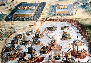
During the 1580 Portuguese succession crisis, the people from São Miguel Island won the naval Battle of Vila Franca against a French squadron that supported the claims of the pretender
António, Prior of Crato
. During this time, the volcano Fogo 2 erupted, destroying the capital city and causing the death of 250 people.
With the Portuguese Restoration War
(1640), the island regained its position as a commercial center, getting new contacts with Brazil
, which was heavily colonized during this period. Some of the island’s historic buildings, including mansions and churches, date from this period. This architectural expansion was due to large profits earned from the production of oranges for export, mainly to Great Britain
.
In 1831, during the Liberal Wars
, after the landing of Liberal troops in Nordeste ordered by the future duke of Terceira
, the resistance to the Absolutist regime on the Island was organized. In 1832, the Army, after declaring the Constitution and recognizing Maria II of Portugal as their queen, left Ponta Delgada. After the troubled period of the Liberal Wars, the previous economic expansion resumed, the port of Ponta Delgada was built, and also new crops such as tea
, pineapple
, and tobacco
were introduced. The development of the fishing industry and the improvement of agricultural products have helped to boost the economy until the present day.
The island became the seat of the Presidency of the Autonomous Region of the Azores, and is the largest political-administrative center in the Azores.
 São Miguel is bisected by many faults from the northwest to southeast in the direction of the Terceira Rift
, a triple junction of the Eurasian
, African
and North American
tectonic plates
. This system is best expressed in the western part of the island with extensive geological formations, such as the Mosteiros Graben
(along the western flank of the Sete Cidades Massif), the Ribeira Grande Graben (along the northern flank of the Água de Pau Massif), and the many cones and fissural structures along the interior of the island. In the ancient crater of Furnas the faults are aligned west-northwest to east-southeast. Zbysewsky (1959), among others (note references) identifies eight geomorphological structures on São Miguel that correspond to the formative features that built the island, including:
São Miguel comprises six volcanic zones, all are Quaternary
in age except the last, which is partly Pliocene
. From west to east these zones are: the trachyte stratovolcano of the Sete Cidades Massif; a field of alkali-basalt cinder cones and lava flows with minor trachyte; the trachyte stratovolcano of the Água de Pau Massif; a field of alkali-basalt cinder cones and lava flows with minor trachyte and tristanite; the trachyte stratovolcano of Furnas; and the Nordeste shield, which includes the Povoação caldera and consists of alkali basalt, tristanite and trachyte. Dormancy ages for these regions include: 400 year for Sete Cidades, 145 for zone 2, 1150 for Água de Pau, and 370 for Furnas, while eruptions in the Nordeste have not occurred in the past 3000 years.
These geomorphological structures have resulted from millions of years of compound growth that began in the eastern portion of the island; around 4 million years ago the Nordeste Volcano burst from the ocean floor in effusive and fissural eruptions. These eruptions were composed of basaltic lava flows and spatter cones whose products reached a height of 1100 metres (3,608.9 ft) forming the mountainous region of Tronqueiro, Planalto dos Graminhais, Espigão dos Bois and Pico Verde (finding its maximum extent in Pico da Vara). But, about 950,000 years ago a secondary volcano system (Volcanic Complex of Povoação) supplanted the eruptions of the Nordeste Volcano, responsible for new basaltic lavas and pyroclastic deposits. With an age of 200,000 years the third volcano on São Miguel, the Água de Pau Volcano started erupting on the western flank of Povoação volcano in two phases. The first phase, composed of the older materials, erupted from lava flows and Trachyte pyroclasts, the secondary phase corresponded to volcanic products that began erupting 400,000 years ago. These latter deposits included pyroclastic, trachyte flows (lava and surges), mud flows and a mixture of basalts. In what would become the western portion of the island a fourth volcano formed: the Sete Cidades Volcano erupted 200,000 years ago and continued to erupt until about 36,000 years ago. Between 100,000 and 3,800 years ago fissural eruptions of integrated lava and basaltic pyroclastic deposits occurred in the center of the island between Água de Pau and Povoaçãp, forming the Fissural Volcanic System of Congro. These eruptions were explosive and fed by activities in the neighboring volcanic systems. At about 100,000 years a secondary system developed along the frontier of the Povoação volcano, the "Furnas Volcano" complex (the youngest volcanic system) in three phases mixing pyroclastic surge
s, trachytes
, and lava flows, as well as explosive materials. Finally, two layers of deposits formed the Fissural Volcanic System of Picos between the volcanic Água de Pau and Sete Cidades from 31,000 years ago unifying the island. This formation integrated lavas, basaltic pyroclasts, tuff cones and trachyte domes into two layers (referred to as the Ponta Delgada and Penhal da Paz sub-depoists) and compiled to about 5,000 years ago.
The ancient laurisilva
forest has mostly been replaced by cultivated fields and imported trees and plants, such as the ubiquitous cryptomeria
trees. There are some hot spring
s (caldeiras), generally located in the center of the island, in the area stretching from Povoação to Nordeste.
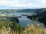
The peak area between Sete Cidades and Fogo is a monogenetic volcanic field
composed of 270 volcanoes. They are primarily made up of basaltic cones which were formed during Strombolian and Hawaiian-style eruptions. This is the part of the island with most recent volcanic activity. The youngest volcanoes are relatively well dated. It is estimated that 19 eruptions have occurred during the last 3,000 years. Several eruptions have been witnessed and recorded by people. The last one took place in the 17th century. The most famous eruption is known as Fogo 2, occurring in 1652.
The highest elevation on São Miguel is the Pico da Vara
at 1103 metres (3,618.8 ft). Lying at the eastern end of the island, it is the focus of a Special Protection Area
containing the largest remnant of laurisilva
forest on the island, which is home to the endemic and critically endangered
bird, the Azores Bullfinch
.
. It functions as a moderating force in the islands, keeping temperatures hovering between 14 °C (57 °F) and 26 °C (79 °F) throughout the year. The island's location also makes it susceptible to many Atlantic storms, and precipitation tends to be elevated during the winter periods.
, Furnas
or Povoação
, river-valleys (such as Ribeira Chã
, Pilar da Bretanha
) or coastal deltas (Mosteiros
). Regardless, these settlements were largely agrarian and concentrated around the parish churches and the many fertile parcels of land. The communities were largely isolated throughout the year, owing to the great distances and rough landscape of the island, and only became integrated with the development of the many road networks that circle and bisect the island. Two cities have developed, largely because the island was divided by mountainous volcanic cones in the interior: Ponta Delgada and Ribeira Grande. Administratively, the island is governed by five municipalities, with Ponta Delgada and Ribeira Grande having more administrative functions associated with their larger populations:
At the local government level, the municipalities include civil parish authority responsible for the provision of services and implementation of municipal initiatives. Based on the ecclesiastical limits established in the history of Portugal, the civil parishes are run by a president, treasurer and secretary at the head of a parish council. These presidents have municipal council standing and represent their constituencies. On the island of São Miguel there are 64 local area authorities, that include:
Azores
The Archipelago of the Azores is composed of nine volcanic islands situated in the middle of the North Atlantic Ocean, and is located about west from Lisbon and about east from the east coast of North America. The islands, and their economic exclusion zone, form the Autonomous Region of the...
archipelago. The island covers 759 km² (293.1 sq mi) and has around 140,000 inhabitants, 45,000 of these people located in the largest city in the archipelago: Ponta Delgada
Ponta Delgada
Ponta Delgada is a city and municipality on the island of São Miguel in the archipelago of the Azores, an autonomous region of Portugal. It includes 44,403 residents in the urban area, and approximately 20,113 inhabitants in the three central parishes that comprise the historical city: São Pedro,...
.
History
Estremadura Province (historical)
Estremadura Province is one of the six historical provinces of Portugal....
, Alto Alentejo
Alto Alentejo Province
Alto Alentejo was a Portuguese province. It was abolished with the Constitution of 1976.The area is now covered by Alto Alentejo Subregion and Alentejo Central Subregion.-Municipalities:*Alandroal Municipality*Alter do Chão Municipality...
, Algarve and Madeira
Madeira
Madeira is a Portuguese archipelago that lies between and , just under 400 km north of Tenerife, Canary Islands, in the north Atlantic Ocean and an outermost region of the European Union...
traveled to São Miguel, under the Carta Régia (a decree of the regency). The fertile soils and temperate climate attracted settlers from other countries, notably French people
French people
The French are a nation that share a common French culture and speak the French language as a mother tongue. Historically, the French population are descended from peoples of Celtic, Latin and Germanic origin, and are today a mixture of several ethnic groups...
and cultural minorities such as Jews
Jews
The Jews , also known as the Jewish people, are a nation and ethnoreligious group originating in the Israelites or Hebrews of the Ancient Near East. The Jewish ethnicity, nationality, and religion are strongly interrelated, as Judaism is the traditional faith of the Jewish nation...
and Moors
Moors
The description Moors has referred to several historic and modern populations of the Maghreb region who are predominately of Berber and Arab descent. They came to conquer and rule the Iberian Peninsula for nearly 800 years. At that time they were Muslim, although earlier the people had followed...
. Its geographic position and fertile soils permitted rapid economic development. The establishment of a military garrison made the island an obligatory port-of-call in the African and Asian commercial trade, while the export of sugar
Sugar
Sugar is a class of edible crystalline carbohydrates, mainly sucrose, lactose, and fructose, characterized by a sweet flavor.Sucrose in its refined form primarily comes from sugar cane and sugar beet...
, and later orchil (a dye exported to Flanders
Flanders
Flanders is the community of the Flemings but also one of the institutions in Belgium, and a geographical region located in parts of present-day Belgium, France and the Netherlands. "Flanders" can also refer to the northern part of Belgium that contains Brussels, Bruges, Ghent and Antwerp...
for the making of cloth) stabilized the island's export trade.
The first capital of the island was Vila Franca do Campo
Vila Franca do Campo
Vila Franca do Campo is a town and a municipality in the southern part of the island of São Miguel in the Portuguese Autonomous Region of the Azores...
, which was devastated by a major earthquake and landslides in 1522. The tragedy helped to elevate the importance of Ponta Delgada
Ponta Delgada
Ponta Delgada is a city and municipality on the island of São Miguel in the archipelago of the Azores, an autonomous region of Portugal. It includes 44,403 residents in the urban area, and approximately 20,113 inhabitants in the three central parishes that comprise the historical city: São Pedro,...
, eventually becoming the new capital in 1546.
During the 1580 Portuguese succession crisis, the people from São Miguel Island won the naval Battle of Vila Franca against a French squadron that supported the claims of the pretender
Pretender
A pretender is one who claims entitlement to an unavailable position of honour or rank. Most often it refers to a former monarch, or descendant thereof, whose throne is occupied or claimed by a rival, or has been abolished....
António, Prior of Crato
António, Prior of Crato
António, Prior of Crato , was a grandson of King Manuel I of Portugal, claimant of the Portuguese throne during the 1580 dynastic crisis, who was King of Portugal as António I of Portugal during 33 days in the continent in 1580, and, after the crowning of Philip II of Spain as King of Portugal,...
. During this time, the volcano Fogo 2 erupted, destroying the capital city and causing the death of 250 people.
With the Portuguese Restoration War
Portuguese Restoration War
Portuguese Restoration War was the name given by nineteenth-century 'romantic' historians to the war between Portugal and Spain that began with the Portuguese revolution of 1640 and ended with the Treaty of Lisbon . The revolution of 1640 ended the sixty-year period of dual monarchy in Portugal...
(1640), the island regained its position as a commercial center, getting new contacts with Brazil
Brazil
Brazil , officially the Federative Republic of Brazil , is the largest country in South America. It is the world's fifth largest country, both by geographical area and by population with over 192 million people...
, which was heavily colonized during this period. Some of the island’s historic buildings, including mansions and churches, date from this period. This architectural expansion was due to large profits earned from the production of oranges for export, mainly to Great Britain
Great Britain
Great Britain or Britain is an island situated to the northwest of Continental Europe. It is the ninth largest island in the world, and the largest European island, as well as the largest of the British Isles...
.
In 1831, during the Liberal Wars
Liberal Wars
The Liberal Wars, also known as the Portuguese Civil War, the War of the Two Brothers, or Miguelite War, was a war between progressive constitutionalists and authoritarian absolutists in Portugal over royal succession that lasted from 1828 to 1834...
, after the landing of Liberal troops in Nordeste ordered by the future duke of Terceira
Duke of Terceira
The title duke of Terceira, de juro e herdade was created by decree of King Pedro IV of Portugal, on 8 November 1832...
, the resistance to the Absolutist regime on the Island was organized. In 1832, the Army, after declaring the Constitution and recognizing Maria II of Portugal as their queen, left Ponta Delgada. After the troubled period of the Liberal Wars, the previous economic expansion resumed, the port of Ponta Delgada was built, and also new crops such as tea
Tea
Tea is an aromatic beverage prepared by adding cured leaves of the Camellia sinensis plant to hot water. The term also refers to the plant itself. After water, tea is the most widely consumed beverage in the world...
, pineapple
Pineapple
Pineapple is the common name for a tropical plant and its edible fruit, which is actually a multiple fruit consisting of coalesced berries. It was given the name pineapple due to its resemblance to a pine cone. The pineapple is by far the most economically important plant in the Bromeliaceae...
, and tobacco
Tobacco
Tobacco is an agricultural product processed from the leaves of plants in the genus Nicotiana. It can be consumed, used as a pesticide and, in the form of nicotine tartrate, used in some medicines...
were introduced. The development of the fishing industry and the improvement of agricultural products have helped to boost the economy until the present day.
The island became the seat of the Presidency of the Autonomous Region of the Azores, and is the largest political-administrative center in the Azores.
Physical geography
Terceira Rift
The Terceira Rift is a geological rift located amidst the Azores islands in the Atlantic Ocean. It runs between the Azores Triple Junction to the west and the Azores-Gibraltar Transform Fault to the southeast. It separates the Eurasian Plate to the north from the African Plate to the south. The...
, a triple junction of the Eurasian
Eurasian Plate
The Eurasian Plate is a tectonic plate which includes most of the continent of Eurasia , with the notable exceptions of the Indian subcontinent, the Arabian subcontinent, and the area east of the Chersky Range in East Siberia...
, African
African Plate
The African Plate is a tectonic plate which includes the continent of Africa, as well as oceanic crust which lies between the continent and various surrounding ocean ridges.-Boundaries:...
and North American
North American Plate
The North American Plate is a tectonic plate covering most of North America, Greenland, Cuba, Bahamas, and parts of Siberia, Japan and Iceland. It extends eastward to the Mid-Atlantic Ridge and westward to the Chersky Range in eastern Siberia. The plate includes both continental and oceanic crust...
tectonic plates
Tectonic Plates
Tectonic Plates is a 1992 independent Canadian film directed by Peter Mettler. Mettler also wrote the screenplay based on the play by Robert Lepage. The film stars Marie Gignac, Céline Bonnier and Robert Lepage.-Plot summary:...
. This system is best expressed in the western part of the island with extensive geological formations, such as the Mosteiros Graben
Graben
In geology, a graben is a depressed block of land bordered by parallel faults. Graben is German for ditch. Graben is used for both the singular and plural....
(along the western flank of the Sete Cidades Massif), the Ribeira Grande Graben (along the northern flank of the Água de Pau Massif), and the many cones and fissural structures along the interior of the island. In the ancient crater of Furnas the faults are aligned west-northwest to east-southeast. Zbysewsky (1959), among others (note references) identifies eight geomorphological structures on São Miguel that correspond to the formative features that built the island, including:
- The Sete Cidades Massif – an area that occupies the extreme western part of the island, and corresponds to a central volcanic craterVolcanic craterA volcanic crater is a circular depression in the ground caused by volcanic activity. It is typically a basin, circular in form within which occurs a vent from which magma erupts as gases, lava, and ejecta. A crater can be of large dimensions, and sometimes of great depth...
and lake-filled calderaCalderaA caldera is a cauldron-like volcanic feature usually formed by the collapse of land following a volcanic eruption, such as the one at Yellowstone National Park in the US. They are sometimes confused with volcanic craters...
, with various cones, deposits of pumicePumicePumice is a textural term for a volcanic rock that is a solidified frothy lava typically created when super-heated, highly pressurized rock is violently ejected from a volcano. It can be formed when lava and water are mixed. This unusual formation is due to the simultaneous actions of rapid...
, lava domes and maarMaarA maar is a broad, low-relief volcanic crater that is caused by a phreatomagmatic eruption, an explosion caused by groundwater coming into contact with hot lava or magma. A maar characteristically fills with water to form a relatively shallow crater lake. The name comes from the local Moselle...
s. In the northeastern flank of this volcano the Mosteiros GrabenGrabenIn geology, a graben is a depressed block of land bordered by parallel faults. Graben is German for ditch. Graben is used for both the singular and plural....
, a tectonic structure created from the collapse of lands and located along a northwest to southeast orientation. Along other regional fractures and radial faults there are ancient spatter cones and lava domeLava dome|250px|thumb|right|Image of the [[rhyolitic]] lava dome of [[Chaitén Volcano]] during its 2008–2009 eruption.In volcanology, a lava dome is a roughly circular mound-shaped protrusion resulting from the slow extrusion of viscous lava from a volcano...
s; - The Picos Region - is situated along a northwest-southeast alignment, and defines a range of spatter cones and relatively level ground between the Sete Cidades and the Água de Pau Massifs;
- The Água de Pau Massif - this central feature corresponds to the central volcano on the island, and includes the Lagoa do Fogo (Lake of Fire), many lava domes and pumice cones. On the northeastern flank of the Massif the Ribeira Grande GrabenGrabenIn geology, a graben is a depressed block of land bordered by parallel faults. Graben is German for ditch. Graben is used for both the singular and plural....
is visible, representing a tectonic depression oriented northwest to southeast; - The Achada das Furnas Plateau - a region with a central plain marked by cones and maars, with deposits along a west-northwest to east-southeast and northwest to southeast;
- Furnas Volcano - located in the eastern part of the island, along the southern coast, and comprising two ancient calderas, occupied by a lake (Lagoa das Furnas). Within the system one can find many pumice cones, maars and lava domes;
- Povoação Volcano - comprising a central caldera, generally well-eroded and whose southern rim has disappeared to the southern coast. Within its interior, marked by several river-valleys and cliffs, are several spatter cones;
- The Tronqueira Region - it occupies the extreme easterly portion of the island and corresponds to a mountainous region, divided by many river-valleys that are usually delineated by tectonic fractures;
- The Northern Coastal Platform - located along the northeastern portion of the island, and marks a zone of relatively moderate topography, limited by the coast to the north and the northern crater rims of Furnas and Povoação volcanoes to the south.
São Miguel comprises six volcanic zones, all are Quaternary
Quaternary
The Quaternary Period is the most recent of the three periods of the Cenozoic Era in the geologic time scale of the ICS. It follows the Neogene Period, spanning 2.588 ± 0.005 million years ago to the present...
in age except the last, which is partly Pliocene
Pliocene
The Pliocene Epoch is the period in the geologic timescale that extends from 5.332 million to 2.588 million years before present. It is the second and youngest epoch of the Neogene Period in the Cenozoic Era. The Pliocene follows the Miocene Epoch and is followed by the Pleistocene Epoch...
. From west to east these zones are: the trachyte stratovolcano of the Sete Cidades Massif; a field of alkali-basalt cinder cones and lava flows with minor trachyte; the trachyte stratovolcano of the Água de Pau Massif; a field of alkali-basalt cinder cones and lava flows with minor trachyte and tristanite; the trachyte stratovolcano of Furnas; and the Nordeste shield, which includes the Povoação caldera and consists of alkali basalt, tristanite and trachyte. Dormancy ages for these regions include: 400 year for Sete Cidades, 145 for zone 2, 1150 for Água de Pau, and 370 for Furnas, while eruptions in the Nordeste have not occurred in the past 3000 years.
These geomorphological structures have resulted from millions of years of compound growth that began in the eastern portion of the island; around 4 million years ago the Nordeste Volcano burst from the ocean floor in effusive and fissural eruptions. These eruptions were composed of basaltic lava flows and spatter cones whose products reached a height of 1100 metres (3,608.9 ft) forming the mountainous region of Tronqueiro, Planalto dos Graminhais, Espigão dos Bois and Pico Verde (finding its maximum extent in Pico da Vara). But, about 950,000 years ago a secondary volcano system (Volcanic Complex of Povoação) supplanted the eruptions of the Nordeste Volcano, responsible for new basaltic lavas and pyroclastic deposits. With an age of 200,000 years the third volcano on São Miguel, the Água de Pau Volcano started erupting on the western flank of Povoação volcano in two phases. The first phase, composed of the older materials, erupted from lava flows and Trachyte pyroclasts, the secondary phase corresponded to volcanic products that began erupting 400,000 years ago. These latter deposits included pyroclastic, trachyte flows (lava and surges), mud flows and a mixture of basalts. In what would become the western portion of the island a fourth volcano formed: the Sete Cidades Volcano erupted 200,000 years ago and continued to erupt until about 36,000 years ago. Between 100,000 and 3,800 years ago fissural eruptions of integrated lava and basaltic pyroclastic deposits occurred in the center of the island between Água de Pau and Povoaçãp, forming the Fissural Volcanic System of Congro. These eruptions were explosive and fed by activities in the neighboring volcanic systems. At about 100,000 years a secondary system developed along the frontier of the Povoação volcano, the "Furnas Volcano" complex (the youngest volcanic system) in three phases mixing pyroclastic surge
Pyroclastic surge
A pyroclastic surge is a fluidized mass of turbulent gas and rock fragments which is ejected during some volcanic eruptions. It is similar to a pyroclastic flow but it has a lower density or contains a much higher proportion of gas to rock ratio, which makes it more turbulent and allows it to rise...
s, trachytes
Trachytes
Trachytes is a genus of mites in the family Trachytidae.-Species:* Trachytes adrianaea Hutu, 2000 * Trachytes aegrota * Trachytes aegrotasimilis Hutu, 2001 * Trachytes aokii Hiramatsu, 1979...
, and lava flows, as well as explosive materials. Finally, two layers of deposits formed the Fissural Volcanic System of Picos between the volcanic Água de Pau and Sete Cidades from 31,000 years ago unifying the island. This formation integrated lavas, basaltic pyroclasts, tuff cones and trachyte domes into two layers (referred to as the Ponta Delgada and Penhal da Paz sub-depoists) and compiled to about 5,000 years ago.
The ancient laurisilva
Laurisilva
Laurisilva or laurissilva is a subtropical forest, found in areas with high humidity and relatively stable and mild temperatures. They are characterised by evergreen, glossy-leaved tree species that look alike with leaves of lauroide type...
forest has mostly been replaced by cultivated fields and imported trees and plants, such as the ubiquitous cryptomeria
Cryptomeria
Cryptomeria is a monotypic genus of conifer in the cypress family Cupressaceae formerly belonging to the family Taxodiaceae; it includes only one species, Cryptomeria japonica . It is endemic to Japan, where it is known as Sugi...
trees. There are some hot spring
Hot spring
A hot spring is a spring that is produced by the emergence of geothermally heated groundwater from the Earth's crust. There are geothermal hot springs in many locations all over the crust of the earth.-Definitions:...
s (caldeiras), generally located in the center of the island, in the area stretching from Povoação to Nordeste.
The peak area between Sete Cidades and Fogo is a monogenetic volcanic field
Monogenetic volcanic field
A monogenetic volcanic field is a volcanic field of small, scattered volcanic vents. These volcanic fields, containing numerous monogenetic volcanoes, are noted for having only one short eruptive event at each volcano, as opposed to regular volcanoes that have several eruptions from the same vent...
composed of 270 volcanoes. They are primarily made up of basaltic cones which were formed during Strombolian and Hawaiian-style eruptions. This is the part of the island with most recent volcanic activity. The youngest volcanoes are relatively well dated. It is estimated that 19 eruptions have occurred during the last 3,000 years. Several eruptions have been witnessed and recorded by people. The last one took place in the 17th century. The most famous eruption is known as Fogo 2, occurring in 1652.
The highest elevation on São Miguel is the Pico da Vara
Pico da Vara
Pico da Vara is the highest mountain on the Portuguese island of São Miguel, in the Azores archipelago of Macaronesia in the Atlantic Ocean. It lies in the east of the island in the Serra da Tronqueira range in the municipality of Nordeste...
at 1103 metres (3,618.8 ft). Lying at the eastern end of the island, it is the focus of a Special Protection Area
Special Protection Area
A Special Protection Area or SPA is a designation under the European Union Directive on the Conservation of Wild Birds.Under the Directive, Member States of the European Union have a duty to safeguard the habitats of migratory birds and certain particularly threatened birds.Together with Special...
containing the largest remnant of laurisilva
Laurisilva
Laurisilva or laurissilva is a subtropical forest, found in areas with high humidity and relatively stable and mild temperatures. They are characterised by evergreen, glossy-leaved tree species that look alike with leaves of lauroide type...
forest on the island, which is home to the endemic and critically endangered
Critically endangered
Version 2010.3 of the IUCN Red List of Threatened Species identified 3744 Critically Endangered species, subspecies and varieties, stocks and subpopulations.Critically Endangered by kingdom:*1993 Animalia*2 Fungi*1745 Plantae*4 Protista-References:...
bird, the Azores Bullfinch
Azores Bullfinch
The Azores Bullfinch , also known as the São Miguel Bullfinch, or locally in Portuguese as the Priolo, is an endangered passerine bird in the true finch family...
.
Climate
Similar to other islands in the archipelago, São Miguel is influenced by ocean currents and winds, and in particular, the cyclonic Gulf StreamGulf Stream
The Gulf Stream, together with its northern extension towards Europe, the North Atlantic Drift, is a powerful, warm, and swift Atlantic ocean current that originates at the tip of Florida, and follows the eastern coastlines of the United States and Newfoundland before crossing the Atlantic Ocean...
. It functions as a moderating force in the islands, keeping temperatures hovering between 14 °C (57 °F) and 26 °C (79 °F) throughout the year. The island's location also makes it susceptible to many Atlantic storms, and precipitation tends to be elevated during the winter periods.
Human geography
Owing to the predominance of volcanic cones and craters in the interior, human settlement has developed primarily along coastal and interior plains. In addition, there are several communities that have developed within ancient craters (such as Sete CidadesSete Cidades
Sete Cidades is also national park in the state of Piauí, Brazil, see Sete Cidades, PiauíSete Cidades is a civil parish in the center of the municipality of Ponta Delgada, that is likewise located in the center of a massive volcanic crater three miles across, also referred to as Sete Cidades...
, Furnas
Furnas
Furnas is a civil parish in the municipality of Povoação on the island of São Miguel in the Azores. The population in 2001 was 1,541, its density is 44.76/km² and the area is 34.43 km². The parish is one of the largest in the island and in the Azores...
or Povoação
Povoação
Povoação is a municipality located in the southern part of São Miguel Island in the Azores. It has a population of 6,696 inhabitants and a total area of 108 km².-Geography:...
, river-valleys (such as Ribeira Chã
Ribeira Chã
Ribeira Chã is a parish in the municipality of Lagoa in the Azores. In 2001 the population was less than 400 inhabitants along a cliff overlooking the Atlantic Ocean, about 2.5 km² in area...
, Pilar da Bretanha
Pilar da Bretanha
Pilar da Bretanha is a civil parish in the municipality of Ponta Delgada on the island of São Miguel, in the Azores. It only became an independent parish recently; on July 10, 2002, it was broken-off from the civil parish of Bretanha along with Ajuda da Bretanha.-History:In a description by...
) or coastal deltas (Mosteiros
Mosteiros
Mosteiros, Portuguese for monasteries, and also referred to, as:=*Mosteiros, a civil parish in the municipality of ArronchesIn the archipelago of the Azores:...
). Regardless, these settlements were largely agrarian and concentrated around the parish churches and the many fertile parcels of land. The communities were largely isolated throughout the year, owing to the great distances and rough landscape of the island, and only became integrated with the development of the many road networks that circle and bisect the island. Two cities have developed, largely because the island was divided by mountainous volcanic cones in the interior: Ponta Delgada and Ribeira Grande. Administratively, the island is governed by five municipalities, with Ponta Delgada and Ribeira Grande having more administrative functions associated with their larger populations:
- Lagoa - the youngest of the municipalities of São Miguel, with a population of 14,126 inhabitants, and incorporating the south-central parishes east of Ponta Delgada;
- Nordeste - literally the north-eastern municipality, well known for an abundance of natural vegatation and the highest point on the island, Pico da Vara;
- Ponta Delgada - the municipality although including the highly industrial city of Ponta Delgada, also includes many rural parishes, as well as the large crater of Sete Cidades;
- Povoação - home to the first colony on the island, Povoação is located in the south-east corner and includes active and dormant volcanic features, including FurnasFurnasFurnas is a civil parish in the municipality of Povoação on the island of São Miguel in the Azores. The population in 2001 was 1,541, its density is 44.76/km² and the area is 34.43 km². The parish is one of the largest in the island and in the Azores...
and the crater of PovoaçãoPovoaçãoPovoação is a municipality located in the southern part of São Miguel Island in the Azores. It has a population of 6,696 inhabitants and a total area of 108 km².-Geography:...
; - Ribeira Grande - second largest municipality, with 30,852 inhabitants (its city received its charter in 1981) and incorporates an extensive area of the northern coast; and
- Vila Franca do Campo - located along the southern coast between Lagoa and Povoação, Vila Franca was the location of the historical capital of São Miguel, until it was almost destroyed by earthquake and landslides in 1522
At the local government level, the municipalities include civil parish authority responsible for the provision of services and implementation of municipal initiatives. Based on the ecclesiastical limits established in the history of Portugal, the civil parishes are run by a president, treasurer and secretary at the head of a parish council. These presidents have municipal council standing and represent their constituencies. On the island of São Miguel there are 64 local area authorities, that include:
- AchadaAchadaAchada is a civil parish in the municipality Nordeste on the island of São Miguel in the Azores. With a land area of 11.54 km² and a population in 2001 of 503, Achada had a population density of 42 inhabitants/km².-History:...
- AchadinhaAchadinhaAchadinha is a parish in the district of Nordeste in the Azores. The population in 2001 is 561, its density is 45.24/km² and the area is 12.4 km². It is located E fo Ribeira Grande, NE of Ponta Delgada , N of Furnas and W of Nordeste. The main industry is agriculture...
- Água de AltoÁgua de AltoÁgua de Alto is a civil parish in the municipality of Vila Franca do Campo in the Portuguese Azores. The population in 2001 was 1624, its density is 88.2/km² and the area is 18.41 km². It is located on a road linking Ponta Delgada, Lagoa and the municipal seat. It is located east of Ponta...
- Água de PauÁgua de PauÁgua de Pau is a civil parish in the municipality of Lagoa in the Portuguese Azores. It is the third-largest by population, but largest parish in the municipality of Lagoa; the population in 2001 was 3,122 in an area of 17.43 km² .-History:There are various theories as to the origin of the...
- Água RetortaÁgua RetortaÁgua Retorta is a parish in the district of Povoação in the Azores. The population in 2001 is 497, its density is 33.2/km² and the area is 12.55 km². It is located E of Vila Franca do Campo, Ribeira Grande and Furnas. It is also located SE of Ribeira Grande. The main industry is agriculture...
- AlgarviaAlgarviaAlgarvia is a civil parish in the municipality of Nordeste, on the island of São Miguel in the Portuguese Azores.-History:...
- Ajuda da BretanhaAjuda da BretanhaAjuda da Bretanha is a northern civil parish in the municipality of Ponta Delgada, on the island of São Miguel in the Azores. It is a relatively new parish, being elevated to this status when the former parish of Bretanha was divided, forming: Ajuda and Pilar...
- ArrifesArrifesArrifes is a civil parish in the municipality of Ponta Delgada on the island of São Miguel in the Azores. In 2001 its population was 6941, covering an area of 25.37 km² .-History:...
- CaboucoCaboucoCabouco is a civil parish in the municipality of Lagoa on the island of São Miguel in the Portuguese Azores. The population in 2001 is 1,736, in an area of approximately is 4.85 km² ....
- CalhetaCalheta=In the archipelago of the Azores:*Calheta, a municipality on the island of São Jorge*Calheta , a civil parish in the municipality of Calheta*Calhetas, a civil parish in the municipality of Ribeira Grande, island of São Miguel...
- CandeláriaCandelária (Ponta Delgada)Candelária is a civil parish in the municipality of Ponta Delgada on São Miguel island in the Azores. The population in 2001 was 1184, its density approximately 136.41/km² and in an area of about 8.68 km²...
- CapelasCapelasCapelas is a civil parish along the northern coast of the municipality of Ponta Delgada, on the island of São Miguel in the Portuguese Azores...
- ConceiçãoConceição-Portugal:*Conceição , a parish in Covilhã Municipality*Conceição , a parish in Faro Municipality*Conceição , a parish in the district of Horta*Conceição , a parish in Ourique Municipality...
- CovoadaCovoadaCovoada is a civil parish in the municipality of Ponta Delgada, on the island of São Miguel in the Azores. The population was 1259 , dispersed in an area is 9.03 km², extending from the Sete Cidades Massif to the urban communities of Ponta Delgada .-History:The parochial church, Nossa Senhora...
- Faial da TerraFaial da TerraFaial da Terra is a civil parish in the municipality of Povoação on the island of São Miguel in the Azores. The population in 2001 is 377, its density is 33.13/km² and the area is 11.38 km². It is located in the southeastern part of the island. The main industry are agriculture. It is connected...
- Fajã de BaixoFajã de BaixoFajã de Baixo is a civil parish in the municipality of Ponta Delgada in the Portuguese Azores. The population in 2001 was 4553, its density is 1121.42/km² and the area is 4.06 km². Faja de Baixo is surrounded by mountains. It is located in the western part of the island of São Miguel and is...
- Fajã de CimaFajã de CimaFajã de Cima is a parish in the district of Ponta Delgada in the Azores. Fajã de Cima is located in the central Picos region of the island of São Miguel, with a population of 3634 and area of approximately 11.89 km²...
- Fenais da AjudaFenais da AjudaFenais da Ajuda is a civil parish in the municipality of Ribeira Grande in the Azores. The population as of 2001 was 1,269, giving it a population density of 94.63 persons/km²; the land area is 13.41 km².-History:...
- Fenais da LuzFenais da LuzFenais da Luz is a civil parish in the municipality of Ponta Delgada on the island of São Miguel in the Portuguese Azores. In 2001 its population was less than 2000 inhabitants in an administrative area that is less than approximately 10 km²...
- FeteirasFeteirasFeteiras is a civil parish in the southwestern coast of the municipality of Ponta Delgada in the Portuguese archipelago of the Azores. The mountains which are covered with trees are to the north, while the Atlantic Ocean lies to the south...
- FurnasFurnasFurnas is a civil parish in the municipality of Povoação on the island of São Miguel in the Azores. The population in 2001 was 1,541, its density is 44.76/km² and the area is 34.43 km². The parish is one of the largest in the island and in the Azores...
- GinetesGinetesGinetes is a civil parish in the municipality of Ponta Delgada on the island of São Miguel in the Azores. There were 1267 inhabitants , in an area of 12.07 km² that lies on the eastern flank of the Sete Cidades Massif, south of the parish Mosteiros, and linked via the Estrada Regional roadway to...
- LivramentoLivramento (Ponta Delgada)Livramento is a civil parish in the municipality of Ponta Delgada in the Azores. Around 2001 there were approximately 3489 inhabitants in this southern coast, that extends into the interior covering an area of 5.59 km²...
- Lomba da FazendaLomba da FazendaLomba da Fazenda is a parish in the district of Nordeste in the Azores. The population in 2001 is 885, its density is 59.7/km² and the area is 14.83 km². It is located . The main industry is agriculture. It is connected with a road linking to Nordeste, Ribeira Grande and Furnas.-Geography:Lomba...
- Lomba da MaiaLomba da MaiaLomba da Maia is a civil parish in the municipality of Ribeira Grande in the Portuguese Azores. In 2001 there were 1,174 in an area that covers 20.3 km² from the northern coast to the interior , on a plateau that overlooks the neighboring parish of Maia...
- Lomba de São PedroLomba de São PedroLomba de São Pedro is a parish in the district of Ribeira Grande in the Azores. The population in 2001 is 309, its density is 44.2/km² and the area is 6.99 km². Lomba de São Pedro is the leastly populated parish in population and density in Ribeira Grande...
- MaiaMaiaMaia is a female given name of Greek origin. Together with other similar words, it may refer to:- Mythology :* Maia , the eldest of the Pleiades in Greek mythology, also identified with an Ancient Italic goddess of spring and the most beautiful....
- MatrizMatriz (Ribeira Grande)Matriz is a parish in the district of Ribeira Grande in the Azores. The population in 2001 is 3552, its density is 328.3/km² and the area is 10.82 km².-Geography:Matriz has a school, a lyceum, a gymnasia, a church and a square ....
- MosteirosMosteiros (Ponta Delgada)Mosteiros is a civil parish in the municipality of Ponta Delgada in the Azores. The population in 2001 was 1196, its density is 130/km² and the area is 9.2 km². It is located in the northwestern part of the island of São Miguel and is connected by roads to Ponta Delgada in the south and...
- Nordeste
- Nossa Senhora dos Remédios
- Nossa Senhora do RósarioNossa Senhora do Rosário (Lagoa)Nossa Senhora do Rosário is a civil parish in the municipality of Lagoa, and represents the largest populated area of this Portuguese concelho. The population in 2001 was 5401, its density is 832.2/km² and the area is 6.49 km²...
- Pico da Pedra
- Pilar da BretanhaPilar da BretanhaPilar da Bretanha is a civil parish in the municipality of Ponta Delgada on the island of São Miguel, in the Azores. It only became an independent parish recently; on July 10, 2002, it was broken-off from the civil parish of Bretanha along with Ajuda da Bretanha.-History:In a description by...
- Ponta GarçaPonta GarçaPonta Garça is a parish in the municipality of Vila Franca do Campo in the Portuguese Azores. The population in 2001 was 3577, its density was 129.1/km² and the area was 27.7 km². It is the largest parish in Vila Franca do Campo. It is located on a road linking Lagoa and Ponta Delgada and the...
- Porto FormosoPorto FormosoPorto Formoso is a civil parish in the municipality of Ribeira Grande in the Portuguese archipelago of the Azores. The population in 2001 was 1267, covering an area of 11.46 km² .-History:...
- Povoação
- Rabo de PeixeRabo de PeixeRabo de Peixe is a parish in the district of Ribeira Grande in the Azores. The population in 2001 was 7407, its density is 437.7/km² and its area is 16.92 km². It is the most populous and most densely populated parish in Ribeira Grande. It has an altitude of 29 m .-Geography:Rabo de...
- RelvaRelvaRelva is a parish in the district of Ponta Delgada in the Azores. The population in 2001 is 2703, its density is 223.39/km² and the area is 12.1 km². Relva are surrounded by mountains near the area including an escarpment slightly east of Relva. It is located in the southwestern part of the...
- RemédiosRemédiosRemédios is a parish in the district of Ponta Delgada in the Azores. The population in 2001 is 997, its density is 178.03/km² and the area is 5.6 km². It is located in the northwestern part of the island of São Miguel and is connected by roads linking Mosteiros and Ribeira Grande...
- Ribeira ChãRibeira ChãRibeira Chã is a parish in the municipality of Lagoa in the Azores. In 2001 the population was less than 400 inhabitants along a cliff overlooking the Atlantic Ocean, about 2.5 km² in area...
- Ribeira das TainhasRibeira das TainhasRibeira das Tainhas is a parish in the municipality of Vila Franca do Campo in the Azores. The population in 2001 is 782, its density is 78.9/km² and the area is 9.91 km². It is the smallest parish in area, population and density.-Geography:...
- Ribeira QuenteRibeira QuenteRibeira Quente is a civil parish in the municipality of Povoação in the Portuguese Azores. The population in 2001 is 798 in an area of 9.04 km² : the smallest in area, the lowest and the southernmost parish in municipality....
- Ribeira SecaRibeira SecaRibeira Seca is Portuguese for dry ravine, an may refer to:-Portugal:In the archipelago of the Azores:* Ribeira Seca , a civil parish in the municipality of Calheta, São Jorge...
- RibeirinhaRibeirinha (Ribeira Grande)Ribeirinha is a parish in the district of Ribeira Grande in the Azores. The population in 2001 is 2124, its density is 118/km² and the area is 18 km²....
- SalgaSalgaSalga is a parish in the municipality of Nordeste in the Azores. The population in 2001 is 550, its density is 71.43/km² and the area is 7.7 km². It is located 1 km E of Achadinha, E of Ribeira Grande and W of Nordeste. The main industry is agriculture. It is connected with a road linking...
- Santa Bárbara (Ribeira Grande)Santa Bárbara (Ribeira Grande)Santa Bárbara is a parish in the district of Ribeira Grande in the Azores. The population according to the 2001 census was 1271, its density was 99.8/km² and the area is 12.73 km²....
- Santa Bárbara (Ponta Delgada)Santa Bárbara (Ponta Delgada)Santa Bárbara is a civil parish in the municipality of Ponta Delgada on the island of São Miguel in the Azores. The population of 880 occupy an area of 8.73 km², approximately 100 inhabitants per kilometer...
- Santa ClaraSanta Clara (Ponta Delgada)Santa Clara is a parish in the district of Ponta Delgada in the Azores. Santa Clara is part of the downtown Ponta Delgada. In July 2002, it separated from a part of the parish of São José.-Geography:...
- Santa CruzSanta Cruz (Lagoa)Santa Cruz is a parish in the municipality of Lagoa in the Azores. The population in 2001 was 3501, in an area of 14.25 km² that extends from the southern coast of São Miguel to the Serra de Água de Pau massif .-Geography:Santa Cruz has a school, a lyceum, a gymnasia and a square...
- SantanaSantana (Nordeste)Santana is a parish in the municipality of Nordeste in the Azores. It is split by a stream into two places known as Feteira Grande and Feteira Pequena. Together, these constitute the parish of Santana. The population in 2001 is 449, its density is 74.21/km² and the area is 6.05 km². The...
- Santo AntónioSanto António-Transportation:Santo António is linked with remote unpaved roads that link to the northern and the southern part of the island as well as to near the mountain....
- Santo António de NordestinhoSanto António de NordestinhoSanto António de Nordestinho is a parish in the municipality of Nordeste, Azores in the Portuguese Azores, located near the village and parish of Nordeste.-History:...
- São BrásSão BrásThere are parishes that have the name São Brás :-In the Azores:*São Brás, a parish in the district of Praia da Vitória*São Brás, a parish in the district of Ribeira Grande-In Portugal:...
- São JoséSão JoséAmong other things there are many civil parishes that have the name São José :-Brazil:*São José, Paulínia, Paulínia, São Paulo*São José, Santa Catarina, Santa Catarina*São José do Alegre, Minas Gerais...
- São MiguelSão Miguel-Brazil:* São Miguel, Brazil, Rio Grande do Norte* Barra de São Miguel, Alagoas, a municipality in the State of Alagoas* Barra de São Miguel, Paraíba, a municipality in the State of Paraíba* São Miguel do Aleixo, a municipality in the State of Sergipe...
- São Pedro (Ponta Delgada)São Pedro (Ponta Delgada)São Pedro is the easternmost parish in the municipality of Ponta Delgada on São Miguel Island in the Azores. It is part of the historic downtown area of Ponta Delgada that includes a 2001 population of 7,177 inhabitants...
- São Pedro (Vila Franca do Campo)São Pedro (Vila Franca do Campo)São Pedro is a parish in the district of Vila Franca do Campo in the Azores. The population in 2001 is 1120, its density is 453/km² and the area is 2.47 km². It is located east of Ponta Delgada and Lagoa, south of Ribeira Grande and west of Furnas and Povoação.-Geography:São Pedro has a...
- São Pedro de NordestinhoSão Pedro de NordestinhoSão Pedro de Nordestinho is a parish in the district of Nordeste in the Azores. It was probably the seat where the old parish of Nodestinho was located. It is located west of Nordeste. The main industry is agriculture. It is connected with a road linking Ponta Delgada and Nordeste. The...
- São Roque
- São SebastiãoSão SebastiãoSão Sebastião is Portuguese for "Saint Sebastian". It may also refer to:-Brazil:* São Sebastião, Alagoas* São Sebastião, São Paulo* Ilha de São Sebastião, São Paulo, alternate name of Ilhabela* São Sebastião do Alto, Rio de Janeiro...
- São Vicente FerreiraSão Vicente FerreiraSão Vicente Ferreira is a parish in the district of Ponta Delgada in the Azores. The population in 2001 is 1664, its density is 145.96/km² and the area is 11.4 km². The Atlantic Ocean is to the north and the land is to the south. It is located in the northwestern part of the island of São...
- Sete CidadesSete CidadesSete Cidades is also national park in the state of Piauí, Brazil, see Sete Cidades, PiauíSete Cidades is a civil parish in the center of the municipality of Ponta Delgada, that is likewise located in the center of a massive volcanic crater three miles across, also referred to as Sete Cidades...
Notable citizens
- Antero de QuentalAntero de QuentalAntero Tarquínio de Quental , old spelling Anthero, , a Portuguese poet, philosopher and writer, whose works became a milestone in the Portuguese language, alongside those of Camões or Bocage....
(18 April 1842 – 11 September 1891), a Portuguese poet and essayist; - Teófilo BragaTeófilo BragaJoaquim Teófilo Fernandes Braga ]] 24 February 1843 – 28 January 1924) was a Portuguese writer, playwright, politician and the leader of the Republican Provisional Government after the abdication of King Manuel II, as well as the second elected President of the First Portuguese Republic, following...
(24 February 1843; São JoséSão José (Ponta Delgada)São José is a civil parish in the municipality and city of Ponta Delgada on the island of São Miguel in the Portuguese archipelago of the Azores. It is one of the constituent parts of the city of Ponta Delgada, including many historical, commercial and residential buildings extending from the...
- 28 January 1924; LisbonLisbonLisbon is the capital city and largest city of Portugal with a population of 545,245 within its administrative limits on a land area of . The urban area of Lisbon extends beyond the administrative city limits with a population of 3 million on an area of , making it the 9th most populous urban...
), a Portuguese writer, playwright, Republican politician, leader of the Republican Provisional Government, and 2nd President of the Republic; - Roberto IvensRoberto IvensRoberto Ivens was a Portuguese explorer of Africa, Geographer, colonial administrator, and an officer of the Portuguese Navy.-Early life:...
(12 June 1850; São PedroSão Pedro (Ponta Delgada)São Pedro is the easternmost parish in the municipality of Ponta Delgada on São Miguel Island in the Azores. It is part of the historic downtown area of Ponta Delgada that includes a 2001 population of 7,177 inhabitants...
- 28 January 1898; Oeiras), a Portuguese explorer of Africa, geographer, colonial administrator, and an officer of the Portuguese Navy; - Natália de Oliveira CorreiaNatália CorreiaNatália de Oliveira Correia, GOSE, GOL was an intellectual, poet and social activist, as well as author of the official lyrics of the Hino dos Açores, the regional anthem of Autonomous Region of the Azores...
, GOSE, GOLOrder of the FreedomOrder of the Freedom can refer to:*Order of Freedom - Yugoslavian military decoration*Order of Liberty - Portuguese honorific civil order...
(13 September 1923; Fajã de BaixoFajã de BaixoFajã de Baixo is a civil parish in the municipality of Ponta Delgada in the Portuguese Azores. The population in 2001 was 4553, its density is 1121.42/km² and the area is 4.06 km². Faja de Baixo is surrounded by mountains. It is located in the western part of the island of São Miguel and is...
- 16 March 1993;LisbonLisbonLisbon is the capital city and largest city of Portugal with a population of 545,245 within its administrative limits on a land area of . The urban area of Lisbon extends beyond the administrative city limits with a population of 3 million on an area of , making it the 9th most populous urban...
) was an intellectual, poet and social activist, as well as author of the official lyrics of the Hino dos AçoresHino dos AçoresThe Azores, an autonomous region of Portugal, has its own, unofficial regional anthem: the Hino dos Açores .-History:The original song was composed by Joaquim Lima, a musician and director, of the Philharmonic Band of Rabo de Peixe, the Filarmónica Progresso do Norte, in the 1890s, when a movement...
, the regional anthem of Autonomous Region of the Azores; - Pedro Miguel Carreiro Resendes, OIH (born 28 April 1973), commonly known as PauletaPauletaPedro Miguel Carreiro Resendes, OIH , commonly known as Pauleta , is a retired Portuguese footballer who played as a striker....
, a footballerFootball (soccer)Association football, more commonly known as football or soccer, is a sport played between two teams of eleven players with a spherical ball...
and all-time leading goal scorer for the Portuguese National TeamPortugal national football teamThe Portugal national football team represents Portugal in association football and is controlled by the Portuguese Football Federation, the governing body for football in Portugal. Portugal's home ground is Estádio Nacional in Oeiras, and their head coach is Paulo Bento...
;