

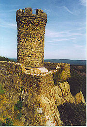
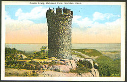
Castle Craig
Encyclopedia
East Peak (New Haven County, Connecticut)
East Peak, , is a prominent traprock mountain in the Hanging Hills of Meriden, Connecticut. Rugged and scenic, the peak rises steeply above the city of Meriden below and is characterized by its vertical cliffs and sweeping views of southern Connecticut and Long Island Sound...
in the Hanging Hills
Hanging Hills
The Hanging Hills of south central Connecticut, USA are a range of mountainous trap rock ridges overlooking the city of Meriden and the Quinnipiac River Valley below. They are a sub-range of the narrow, linear Metacomet Ridge that extends from Long Island Sound near New Haven, Connecticut, north...
, is constructed of trap rock
Trap rock
Trap rock is a form of igneous rock that tends to form polygonal vertical fractures, most typically hexagonal, but also four to eight sided. The fracture pattern forms when magma of suitable chemical composition intrudes as a sill or extrudes as a thick lava flow, and slowly cools.Because of the...
and is 32 feet (10 m) in height and has a base 58 feet (18 m) in circumference . A metal interior stairway is used to ascend the observation deck on top. It stands 976 feet (297 m) above sea level and provides an expansive view of the greater Meriden, Connecticut
Meriden, Connecticut
Meriden is a city in New Haven County, Connecticut, United States. According to 2005 Census Bureau estimates, the population of the city is 59,653.-History:...
area.
Origin and details
Castle Craig, dedicated October 29, 1900 and given to the people of Meriden, Connecticut by Walter Hubbard is part of the 1800 acres (7.3 km²) Hubbard ParkHubbard Park
Hubbard Park, located in the Hanging Hills of Connecticut, is a wooded, mountainous park located just north of downtown urban Meriden, Connecticut. It comprises approximately of carefully kept woodlands, streams, dramatic cliff faces, flower gardens, and the James Barry bandshell and picnic...
named after Hubbard. There are hiking trails to the tower (most notably the 51 miles (82.1 km) Metacomet Trail
Metacomet Trail
The Metacomet Trail is a Blue-Blazed hiking trail that traverses the Metacomet Ridge of central Connecticut and is a part of the newly designated New England National Scenic Trail. Despite being easily accessible and close to large population centers, the trail is considered remarkably rugged and...
) as well as Reservoir Road which is open for vehicular traffic from April to October - 10 AM to 4:45 PM. Walkers and joggers are allowed use of this road 365 days of the year during normal park operating hours which is basically sunrise to sunset. From the top of the observation tower, 1002 feet (305 m) elevation, it is possible to see New Haven and Long Island Sound
Long Island Sound
Long Island Sound is an estuary of the Atlantic Ocean, located in the United States between Connecticut to the north and Long Island, New York to the south. The mouth of the Connecticut River at Old Saybrook, Connecticut, empties into the sound. On its western end the sound is bounded by the Bronx...
25 miles (40.2 km) to the south. To the west, the foothills of the Berkshires are visible; to the north, the Hartford skyline as well as the summit of Mount Tom
Mount Tom (Massachusetts)
Mount Tom, , is a steep, rugged traprock mountain peak on the west bank of the Connecticut River 4.5 miles northwest of downtown Holyoke, Massachusetts. The mountain is the southernmost and highest peak of the Mount Tom Range and the highest traprock peak of the long Metacomet Ridge...
in Massachusetts
Massachusetts
The Commonwealth of Massachusetts is a state in the New England region of the northeastern United States of America. It is bordered by Rhode Island and Connecticut to the south, New York to the west, and Vermont and New Hampshire to the north; at its east lies the Atlantic Ocean. As of the 2010...
.
The inspiration for the tower’s design has been disputed for years. Some say Walter Hubbard, a world traveler, was inspired by a Norman
Normans
The Normans were the people who gave their name to Normandy, a region in northern France. They were descended from Norse Viking conquerors of the territory and the native population of Frankish and Gallo-Roman stock...
French tower; others by a 12th Century Turkish tower on the Danube
Danube
The Danube is a river in the Central Europe and the Europe's second longest river after the Volga. It is classified as an international waterway....
; still others maintain that it was patterned upon an ancient tower in Craigellachie, Scotland
Craigellachie, Scotland
Craigellachie is a small village in Moray, Scotland, at the confluence of the River Spey and River Fiddich , in walking distance of the town of Aberlour....
.
Dedication of Tower
A large number of members of the Court of Common Council, together with other dignitaries attended an oyster roast in the shadow of the Tower. Westbound trolleys were crowded with citizens who used this form of transportation to bring them to the park area from where they had a long, arduous trek, on foot, to the Tower.
There were also a number of persons who drove to the top of the mountain in their own carriages. At two o’clock, it was estimated that approximately 250 guests were in attendance. Their genial host, Mr. Hubbard, had provided six barrels of clams. These were roasted over a big fire under the direction of C.W.F. Pardee of the Winthrop Hotel and P.J. Quigley, a local contractor, with the assistance of twelve men. The Tower itself was the center of attraction and nearly everyone had something to say concerning the beautiful scenery and Mr. Hubbard’s benevolence. During the afternoon, several group photographs were taken. Three cheers were given to Mr. Hubbard by the visitors. They were called for by Judge Wilbur F. Davis, who acclaimed Mr. Hubbard as the “first citizen of Meriden”.A large flag was raised on the tower at noon by Contractor Quigley and as it floated to the breeze three rousing cheers were given.
Plaque
A plaque at the bottom of the tower reads as follows:
Castle Craig
Dedicated October 29. 1900
Castle Craig Tower stands 32 feet (9.8 m) high on 976 feet (297.5 m) east peak in Meriden's Olmsted designed Hubbard Park. It has the distinction of being the highest point within 25 miles (40.2 km) of the coast from Maine to Florida. Its design origins are clouded. Some say its native trap rock construction resembles Norman watchtowers on Europe's Rhine River while others claim it was modeled and named after an ancient castle in Scotland.
Meriden industrialist Walter Hubbard donated the tower and the surrounding park, which a grateful Meriden named after him. The tower is one of the highlights of the 1800 acres (7.3 km²) park from its observation deck. Looking south one can observe Long Island Sound and on a clear day, the outline of Long Island itself. To the north, Southern Massachusetts Berkshire Hills come into view. Hubbard Park is on the National Register of Historic Places.
Although the plaque indicates that East Peak is "the highest point within 25 miles (40.2 km) of the coast from Maine to Florida," West Peak, just 2000 feet (610 m) to the west, at 1,024 feet (312 m), is higher than both East Peak and the tower. Both East and West Peak are lower than a number of mountains in the Downeast coastal region of Maine
Maine
Maine is a state in the New England region of the northeastern United States, bordered by the Atlantic Ocean to the east and south, New Hampshire to the west, and the Canadian provinces of Quebec to the northwest and New Brunswick to the northeast. Maine is both the northernmost and easternmost...
.