

Grove, Virginia
Encyclopedia
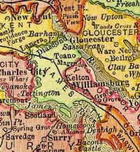
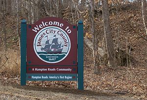
James City County, Virginia
James City County is a county located on the Virginia Peninsula in the Hampton Roads metropolitan area of the Commonwealth of Virginia, a state of the United States. Its population was 67,009 , and it is often associated with Williamsburg, an independent city, and Jamestown which is within the...
in the Peninsula
Virginia Peninsula
The Virginia Peninsula is a peninsula in southeast Virginia, USA, bounded by the York River, James River, Hampton Roads and Chesapeake Bay.Hampton Roads is the common name for the metropolitan area that surrounds the body of water of the same name...
subregion of Virginia
Virginia
The Commonwealth of Virginia , is a U.S. state on the Atlantic Coast of the Southern United States. Virginia is nicknamed the "Old Dominion" and sometimes the "Mother of Presidents" after the eight U.S. presidents born there...
in the United States
United States
The United States of America is a federal constitutional republic comprising fifty states and a federal district...
. It is located in the center of the Historic Triangle
Historic Triangle
The Historic Triangle is located on the Virginia Peninsula of the United States and includes the colonial communities of Jamestown, Colonial Williamsburg, and Yorktown, with many restored attractions linked by the Colonial Parkway in James City and York counties and the City of...
of Colonial Virginia, communities linked by the Colonial Parkway
Colonial Parkway
Colonial Parkway is a scenic 23-mile parkway linking the three popular attractions of Virginia's Historic Triangle of colonial-era communities, Jamestown, Williamsburg, and Yorktown...
; the area is one of the busiest tourist destinations in the world.
Grove is located about 7 miles (11.3 km) east of Williamsburg
Williamsburg, Virginia
Williamsburg is an independent city located on the Virginia Peninsula in the Hampton Roads metropolitan area of Virginia, USA. As of the 2010 Census, the city had an estimated population of 14,068. It is bordered by James City County and York County, and is an independent city...
along U.S. Route 60. Grove is bordered by the James River
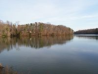
James River (Virginia)
The James River is a river in the U.S. state of Virginia. It is long, extending to if one includes the Jackson River, the longer of its two source tributaries. The James River drains a catchment comprising . The watershed includes about 4% open water and an area with a population of 2.5 million...
and separated from the Newport News
Newport News, Virginia
Newport News is an independent city located in the Hampton Roads metropolitan area of Virginia. It is at the southeastern end of the Virginia Peninsula, on the north shore of the James River extending southeast from Skiffe's Creek along many miles of waterfront to the river's mouth at Newport News...
city limits near Lee Hall
Lee Hall, Virginia
Lee Hall is a former unincorporated town long located in the former Warwick County. Since 1958, Lee Hall has been a suburban community in the extreme western portion of the independent city of Newport News in the Commonwealth of Virginia....
by Skiffe's Creek
Skiffe's Creek
Skiffe's Creek is located in James City County and the independent city of Newport News in the Virginia Peninsula area of the Hampton Roads region of southeastern Virginia in the United States...
.
Historic places in Grove related to Virginia colonial past include the archaeological site of Wolstenholme Towne
Wolstenholme Towne
Wolstenholme Towne was a fortified settlement in the Virginia Colony begun with a population of about 40 settlers of the Virginia Company of London which was located about 7 miles downstream from Jamestown. Named for Sir John Wolstenholme, one of the investors, it was established about 1618 on a...
, the administrative center of Martin's Hundred
Martin's Hundred
Martin's Hundred was an early 17th century plantation located along about ten miles of the north shore of the James River in the Virginia Colony east of Jamestown in the southeastern portion of present-day James City County, Virginia...
. It was rediscovered in 1976 on the grounds of Carter's Grove Plantation, built in 1755. The plantation was occupied by private owners through the 1960s. Then it was owned and operated by the Colonial Williamsburg Foundation and open to the public from the 1970s until 2003. In 2007 the property was sold back into private ownership.
Grove's contemporary development began with African-American settlement by freedmen from Carter's Grove and other plantations following the American Civil War
American Civil War
The American Civil War was a civil war fought in the United States of America. In response to the election of Abraham Lincoln as President of the United States, 11 southern slave states declared their secession from the United States and formed the Confederate States of America ; the other 25...
. Its population was fewer than 100 people until after the turn of the twentieth century. During the two World Wars, Grove increased markedly in population. In part this was due to attracting hundreds of displaced people, mostly African American
African American
African Americans are citizens or residents of the United States who have at least partial ancestry from any of the native populations of Sub-Saharan Africa and are the direct descendants of enslaved Africans within the boundaries of the present United States...
, who were uprooted by federal land acquisition for major waterfront military installations in nearby James City and York counties. Navy bases established were the Naval Weapons Station Yorktown
Naval Weapons Station Yorktown
Naval Weapons Station Yorktown is a United States Navy base in York County, James City County, and Newport News in the Hampton Roads region of Virginia...
, the Cheatham Annex supply complex, and Camp Peary
Camp Peary
Camp Peary is a military reservation in York County near Williamsburg, Virginia. Officially it is referred to as the Armed Forces Experimental Training Activity under the auspices of the Department of Defense, but it is widely believed to be the location of a covert CIA training facility known...
.
As of early 2008, many new homes were under construction in Grove. Along the southeastern edge, available sites and frontage on the James River and Skiffe's Creek are zoned for industrial
Industrial park
An industrial park is an area zoned and planned for the purpose of industrial development...
purposes. These have been attractive to developers of new and expanded businesses.
Geography
James River (Virginia)
The James River is a river in the U.S. state of Virginia. It is long, extending to if one includes the Jackson River, the longer of its two source tributaries. The James River drains a catchment comprising . The watershed includes about 4% open water and an area with a population of 2.5 million...
to the south and York County
York County, Virginia
York County is a county located on the north side of the Virginia Peninsula in the Hampton Roads metropolitan area of the Commonwealth of Virginia, a state of the United States. Situated on the York River and many tributaries, the county seat is the unincorporated town of Yorktown...
to the north. With the exception of lowlands near the river, most of Grove was originally heavily wooded. Much of it still is.
Grove Creek and Skiffe's Creek
Skiffe's Creek
Skiffe's Creek is located in James City County and the independent city of Newport News in the Virginia Peninsula area of the Hampton Roads region of southeastern Virginia in the United States...
, each tributaries of the James River, provide local drainage. The latter also constitutes the eastern border of Grove (and the county), which adjoins the Lee Hall
Lee Hall, Virginia
Lee Hall is a former unincorporated town long located in the former Warwick County. Since 1958, Lee Hall has been a suburban community in the extreme western portion of the independent city of Newport News in the Commonwealth of Virginia....
area of the independent city
Independent city
An independent city is a city that does not form part of another general-purpose local government entity. These type of cities should not be confused with city-states , which are fully sovereign cities that are not part of any other sovereign state.-Historical precursors:In the Holy Roman Empire,...
of Newport News
Newport News, Virginia
Newport News is an independent city located in the Hampton Roads metropolitan area of Virginia. It is at the southeastern end of the Virginia Peninsula, on the north shore of the James River extending southeast from Skiffe's Creek along many miles of waterfront to the river's mouth at Newport News...
.
The former Chesapeake and Ohio Railway
Chesapeake and Ohio Railway
The Chesapeake and Ohio Railway was a Class I railroad formed in 1869 in Virginia from several smaller Virginia railroads begun in the 19th century. Led by industrialist Collis P...
(C&O) runs along the northern edge of Grove. It is now part of the Peninsula Subdivision of CSX Transportation
CSX Transportation
CSX Transportation operates a Class I railroad in the United States known as the CSX Railroad. It is the main subsidiary of the CSX Corporation. The company is headquartered in Jacksonville, Florida, and owns approximately 21,000 route miles...
.
Native Americans
For thousands of years, various cultures of indigenous peoplesIndigenous peoples
Indigenous peoples are ethnic groups that are defined as indigenous according to one of the various definitions of the term, there is no universally accepted definition but most of which carry connotations of being the "original inhabitants" of a territory....
occupied areas along the waterways. Prior to the arrival of Spanish and English settlers in the 16th and 17th centuries, they were semi-nomadic hunter-gatherer
Hunter-gatherer
A hunter-gatherer or forage society is one in which most or all food is obtained from wild plants and animals, in contrast to agricultural societies which rely mainly on domesticated species. Hunting and gathering was the ancestral subsistence mode of Homo, and all modern humans were...
s, although more complex civilizations arose among the Mississippian culture. Scholars believe a major historic American Indian village is located somewhere nearby, although the site has not been identified. The site of the historic Kiskiack
Kiskiack
Kiskiack was a Native American tribal group of the Powhatan Confederacy. The name means "Wide Land" or "Bread Place" in the native language, one of the Virginia Algonquian languages. It was also the name of their village on the Virginia Peninsula. Later English colonists adopted the name for...
Indian village, Chiskiack, was a few miles to the north. The Kiskiack were one of a number of Algonquian
Algonquian languages
The Algonquian languages also Algonkian) are a subfamily of Native American languages which includes most of the languages in the Algic language family. The name of the Algonquian language family is distinguished from the orthographically similar Algonquin dialect of the Ojibwe language, which is a...
-speaking historic tribes at the time of encounter with the English.
When the English settlers established Jamestown
Jamestown, Virginia
Jamestown was a settlement in the Colony of Virginia. Established by the Virginia Company of London as "James Fort" on May 14, 1607 , it was the first permanent English settlement in what is now the United States, following several earlier failed attempts, including the Lost Colony of Roanoke...
in 1607, the Powhatan Paramount Chiefdom
Powhatan
The Powhatan is the name of a Virginia Indian confederation of tribes. It is estimated that there were about 14,000–21,000 of these native Powhatan people in eastern Virginia when the English settled Jamestown in 1607...
included most Native tribes in the area. There were a few that were unaffiliated. The paramount chief, known as the Powhatan
Powhatan
The Powhatan is the name of a Virginia Indian confederation of tribes. It is estimated that there were about 14,000–21,000 of these native Powhatan people in eastern Virginia when the English settled Jamestown in 1607...
, had created his powerful empire in the late 16th and early 17th centuries. He conquered or affiliated by agreement with approximately 30 tribes whose territory covered much of southeastern Virginia. This was called Tenakomakah. A capital of this confederacy, Werowocomoco
Werowocomoco
Werowocomoco was a village that served as the political center of the Powhatan Paramount Chiefdom, a grouping of about 30 Virginia Indian tribes speaking an Algonquian language...
, was located near the north bank of the York River
York River (Virginia)
The York River is a navigable estuary, approximately long, in eastern Virginia in the United States. It ranges in width from at its head to near its mouth on the west side of Chesapeake Bay. Its watershed drains an area including portions of 17 counties of the coastal plain of Virginia north...
in present-day Gloucester County
Gloucester County, Virginia
Gloucester County is within the Commonwealth of Virginia in the Hampton Roads metropolitan area in the USA. Formed in 1651 in the Virginia Colony, the county was named for Henry Stuart, Duke of Gloucester, third son of King Charles I of Great Britain. Located in the Middle Peninsula region, it...
, about 15 miles (24.1 km) as the crow flies from Grove.
By the mid-17th century, the English had forced Native Americans remaining in the area on to reservations north of the York River. By working and living together, some had assimilated into the general population of European colonists and freed slaves of African heritage. Over the decades, white indentured servant women, African men, and few Indians married and created free mixed-race populations before the American Revolution
American Revolution
The American Revolution was the political upheaval during the last half of the 18th century in which thirteen colonies in North America joined together to break free from the British Empire, combining to become the United States of America...
.
Martin's Hundred, Wolstenholme Towne
The Grove Community was probably named for nearby Grove Creek, which drains into the James RiverJames River (Virginia)
The James River is a river in the U.S. state of Virginia. It is long, extending to if one includes the Jackson River, the longer of its two source tributaries. The James River drains a catchment comprising . The watershed includes about 4% open water and an area with a population of 2.5 million...
about 6 miles (9.7 km) east (downstream) of Jamestown
Jamestown, Virginia
Jamestown was a settlement in the Colony of Virginia. Established by the Virginia Company of London as "James Fort" on May 14, 1607 , it was the first permanent English settlement in what is now the United States, following several earlier failed attempts, including the Lost Colony of Roanoke...
. Grove Wharf at the confluence
Confluence
Confluence, in geography, describes the meeting of two or more bodies of water.Confluence may also refer to:* Confluence , a property of term rewriting systems...
of Grove Creek and the river is shown on some early maps of Virginia. It may also have been named after Carter's Grove Plantation, where many of the former slaves had worked before the American Civil War
American Civil War
The American Civil War was a civil war fought in the United States of America. In response to the election of Abraham Lincoln as President of the United States, 11 southern slave states declared their secession from the United States and formed the Confederate States of America ; the other 25...
led to their emancipation. Many likely continued as tenant farmers and workers after the war.
Initially, the English of the Virginia Company of London chose Jamestown for their first settlement of the Virginia Colony. They arrived in 1607 in a fleet of three ships commanded by Christopher Newport
Christopher Newport
Christopher Newport was an English seaman and privateer. He is best known as the captain of the Susan Constant, the largest of three ships which carried settlers for the Virginia Company in 1607 on the way to find the settlement at Jamestown in the Virginia Colony, which became the first permanent...
. (See main article Jamestown, Virginia
Jamestown, Virginia
Jamestown was a settlement in the Colony of Virginia. Established by the Virginia Company of London as "James Fort" on May 14, 1607 , it was the first permanent English settlement in what is now the United States, following several earlier failed attempts, including the Lost Colony of Roanoke...
) After five difficult years, the new colony gradually began expanding. Settlers established plantation
Plantation
A plantation is a long artificially established forest, farm or estate, where crops are grown for sale, often in distant markets rather than for local on-site consumption...
s along the James River
James River (Virginia)
The James River is a river in the U.S. state of Virginia. It is long, extending to if one includes the Jackson River, the longer of its two source tributaries. The James River drains a catchment comprising . The watershed includes about 4% open water and an area with a population of 2.5 million...
, largely to grow non-native strains of tobacco
Tobacco
Tobacco is an agricultural product processed from the leaves of plants in the genus Nicotiana. It can be consumed, used as a pesticide and, in the form of nicotine tartrate, used in some medicines...
. This was introduced and successfully exported in 1612 by colonist John Rolfe
John Rolfe
John Rolfe was one of the early English settlers of North America. He is credited with the first successful cultivation of tobacco as an export crop in the Colony of Virginia and is known as the husband of Pocahontas, daughter of the chief of the Powhatan Confederacy.In 1961, the Jamestown...
, who later married Pocahontas
Pocahontas
Pocahontas was a Virginia Indian notable for her association with the colonial settlement at Jamestown, Virginia. She was the daughter of Chief Powhatan, the head of a network of tributary tribal nations in Tidewater Virginia...
, daughter of the Powhatan
Powhatan
The Powhatan is the name of a Virginia Indian confederation of tribes. It is estimated that there were about 14,000–21,000 of these native Powhatan people in eastern Virginia when the English settled Jamestown in 1607...
.
About 7 miles (11.3 km) downstream from Jamestown on the north bank of the river, just east of Grove Creek, the Grove area was originally settled by English colonists in 1618 as part of Martin's Hundred
Martin's Hundred
Martin's Hundred was an early 17th century plantation located along about ten miles of the north shore of the James River in the Virginia Colony east of Jamestown in the southeastern portion of present-day James City County, Virginia...
. The proprietary plantation of over 20,000 acres (80 km²) was an enterprise of the Martin's Hundred Society, a London-based investment group operating under the auspices of the Virginia Company of London. Not far from the riverfront, the new Wolstenholme Towne
Wolstenholme Towne
Wolstenholme Towne was a fortified settlement in the Virginia Colony begun with a population of about 40 settlers of the Virginia Company of London which was located about 7 miles downstream from Jamestown. Named for Sir John Wolstenholme, one of the investors, it was established about 1618 on a...
, the Martin's Hundred administrative center, was established.
Most of the population of Wolstenholme Towne was killed in the Indian Massacre of 1622
Indian massacre of 1622
The Indian Massacre of 1622 occurred in the Colony of Virginia, in what now belongs to the United States of America, on Friday, March 22, 1622...
, one of the largest incidents of loss of life by Virginia settlers during the colonial years. Colonists rebuilt the settlement a few years later, and protected it by a cross-peninsula palisade
Palisade
A palisade is a steel or wooden fence or wall of variable height, usually used as a defensive structure.- Typical construction :Typical construction consisted of small or mid sized tree trunks aligned vertically, with no spacing in between. The trunks were sharpened or pointed at the top, and were...
to the west completed in 1634. They abandoned Wolstenholme Towne around 1643 after Williamsburg
Williamsburg
Williamsburg may refer to:*Williamsburg, former name of Kernville , California*Williamsburg, Colorado*Williamsburg, Florida*Williamsburg, Dunwoody, Georgia*Williamsburg, Indiana*Williamsburg, Iowa*Williamsburg, Kansas*Williamsburg, Kentucky...
was made the capital. The structures fell into ruin and the site became taken over by vegetation, lost until 1976 (see below).
Martin's Hundred Parish Church was established by the Church of England
Church of England
The Church of England is the officially established Christian church in England and the Mother Church of the worldwide Anglican Communion. The church considers itself within the tradition of Western Christianity and dates its formal establishment principally to the mission to England by St...
, and served the area including Wolstenholme Towne. It was later combined with Yorkhampton Parish in adjacent York County
York County, Virginia
York County is a county located on the north side of the Virginia Peninsula in the Hampton Roads metropolitan area of the Commonwealth of Virginia, a state of the United States. Situated on the York River and many tributaries, the county seat is the unincorporated town of Yorktown...
.
Royal colony, creation of shires (counties)
Virginia Company
The Virginia Company refers collectively to a pair of English joint stock companies chartered by James I on 10 April1606 with the purposes of establishing settlements on the coast of North America...
lost its charter in 1624, Virginia became a royal colony. In 1634, the English Crown created eight shires
Shires of Virginia
The eight Shires of Virginia were formed in 1634 in the Virginia Colony. These shires were based on a form of local government used in England at the time, and were redesignated as counties a few years later...
(i.e., counties) in the colony of Virginia, which then had a total population of approximately 5,000 inhabitants. James City Shire
James City Shire
James City Shire was formed in the British colony of Virginia in 1634.During the 17th century, shortly after establishment of Jamestown in 1607, English settlers and explored and began settling the areas adjacent to Hampton Roads....
, as well as the James River and Jamestown, took its name from King James I
James I of England
James VI and I was King of Scots as James VI from 24 July 1567 and King of England and Ireland as James I from the union of the English and Scottish crowns on 24 March 1603...
, the father of the then-king, Charles I
Charles I of England
Charles I was King of England, King of Scotland, and King of Ireland from 27 March 1625 until his execution in 1649. Charles engaged in a struggle for power with the Parliament of England, attempting to obtain royal revenue whilst Parliament sought to curb his Royal prerogative which Charles...
. About 1642-43, the name of the James City Shire was changed to James City County.
Slavery, freedom
James City County received the first slaves whom the English imported to Virginia. Beginning in 1619, the English brought Africans to the colony as indentured servantIndentured servant
Indentured servitude refers to the historical practice of contracting to work for a fixed period of time, typically three to seven years, in exchange for transportation, food, clothing, lodging and other necessities during the term of indenture. Usually the father made the arrangements and signed...
s. Increasingly toward the end of the 17th century, they hardened the labor system to create a racial caste of slavery for African workers and their families. Dutch and British ships transported large numbers of slaves from Africa
Africa
Africa is the world's second largest and second most populous continent, after Asia. At about 30.2 million km² including adjacent islands, it covers 6% of the Earth's total surface area and 20.4% of the total land area...
to the Virginia Colony. On the labor-intensives tobacco plantations, planters replaced indentured laborers with slaves, who also served as household and skilled workers. In the later 17th and 18th centuries, economic conditions improved in England, so the supply of indentured laborers decreased.
Early Africans became free after serving their period of indenture. Some individual slaves were freed as early as the mid-17th century by manumission
Manumission
Manumission is the act of a slave owner freeing his or her slaves. In the United States before the passage of the Thirteenth Amendment to the United States Constitution, which abolished most slavery, this often happened upon the death of the owner, under conditions in his will.-Motivations:The...
. Some earned their freedom by separate labor, and others escaped. By far the greatest number of free African-American families in Virginia during colonial times were formed by marriage and unions between white working-class women and African men, whether indentured servant, slave or free. The children and their descendants were free because they had the status of the mother.
Known as free Negroes or free people of color
Free people of color
A free person of color in the context of the history of slavery in the Americas, is a person of full or partial African descent who was not enslaved...
, some of the people stayed in the area. Others migrated to urban or frontier areas away from the plantation areas where racial strictures were more severe. Richmond, which was an economic center, and Petersburg
Petersburg, Virginia
Petersburg is an independent city in Virginia, United States located on the Appomattox River and south of the state capital city of Richmond. The city's population was 32,420 as of 2010, predominantly of African-American ethnicity...
, which had industrial jobs, became early centers of free blacks in Virginia.
There was mass emancipation of slaves during the years of the American Civil War
American Civil War
The American Civil War was a civil war fought in the United States of America. In response to the election of Abraham Lincoln as President of the United States, 11 southern slave states declared their secession from the United States and formed the Confederate States of America ; the other 25...
(1861-1865). Despite Virginia's secession
Secession
Secession is the act of withdrawing from an organization, union, or especially a political entity. Threats of secession also can be a strategy for achieving more limited goals.-Secession theory:...
from the Union in 1861, the US Army retained control of Fort Monroe
Fort Monroe
Fort Monroe was a military installation in Hampton, Virginia—at Old Point Comfort, the southern tip of the Virginia Peninsula...
at the eastern end of the Virginia Peninsula. It became a destination for slaves seeking freedom behind Union lines. By 1863, many heard President Lincoln
Abraham Lincoln
Abraham Lincoln was the 16th President of the United States, serving from March 1861 until his assassination in April 1865. He successfully led his country through a great constitutional, military and moral crisis – the American Civil War – preserving the Union, while ending slavery, and...
's Emancipation Proclamation
Emancipation Proclamation
The Emancipation Proclamation is an executive order issued by United States President Abraham Lincoln on January 1, 1863, during the American Civil War using his war powers. It proclaimed the freedom of 3.1 million of the nation's 4 million slaves, and immediately freed 50,000 of them, with nearly...
read under the Emancipation Oak
Emancipation Oak
Emancipation Oak is a historic tree located on the campus of Hampton University in what is now the City of Hampton, Virginia. The large sprawling oak is 98 feet in diameter, with branches which extend upward as well as laterally...
, now on the grounds of Hampton University
Hampton University
Hampton University is a historically black university located in Hampton, Virginia, United States. It was founded by black and white leaders of the American Missionary Association after the American Civil War to provide education to freedmen.-History:...
.
After the War, many freedmen settled in inland areas of the Peninsula, either as landowners, tenant farmers, or renters who worked as watermen. While the southern side of the peninsula along the James River had long been occupied by large plantations, the northern side along the York River
York River (Virginia)
The York River is a navigable estuary, approximately long, in eastern Virginia in the United States. It ranges in width from at its head to near its mouth on the west side of Chesapeake Bay. Its watershed drains an area including portions of 17 counties of the coastal plain of Virginia north...
, west of Yorktown
Yorktown, Virginia
Yorktown is a census-designated place in York County, Virginia, United States. The population was 220 in the 2000 census. It is the county seat of York County, one of the eight original shires formed in colonial Virginia in 1634....
, had not been as heavily developed. Many freedmen moved into this area, establishing close-knit communities in mixed towns, and majority-black towns such as Lackey
Lackey, Virginia
Lackey was a small unincorporated community near Yorktown in York County, Virginia, United States...
and Magruder
Magruder, Virginia
Magruder was a small unincorporated town in Virginia near Williamsburg in York County. Now extinct, it once had its own church, post office, cemetery, lodge, and homes. Magruder is considered one of the many lost towns of Virginia. The land on which it stood is now part of the US military...
.
Carter's Grove
More than 100 years after Wolstenholme Towne was abandoned, Carter's Grove Plantation was built on part of the Martin's Hundred land for Carter Burwell. He was the son of Elizabeth Carter Burwell and her husband Nathaniel Burwell. Carter Burwell was the grandson of the wealthy planter Robert "King" CarterRobert Carter I
Robert "King" Carter , of Lancaster County, was a colonist in Virginia and became one of the wealthiest men in the colonies....
(of Lancaster County
Lancaster County, Virginia
As of the census of 2000, there were 11,567 people, 5,004 households, and 3,412 families residing in the county. The population density was 87 people per square mile . There were 6,498 housing units at an average density of 49 per square mile...
). He bequeathed the land before his death, requiring that it be called Carter's Grove.
The new plantation
Plantation
A plantation is a long artificially established forest, farm or estate, where crops are grown for sale, often in distant markets rather than for local on-site consumption...
home was completed in 1755. In its long occupancy since then, the Carter's Grove mansion was renovated by a series of owners, the last major changes being of the late 1920s era. The last private owner died around 1964. The plantation moved into philanthropic ownership.
The Colonial Williamsburg Foundation (CW) owned the plantation from 1969 until 2007. It furnished the mansion in many period pieces, primarily of the 19th and early 20th centuries. Some of these were antiques acquired in the 1920s from an auction at Westover Plantation
Westover Plantation
Westover Plantation is located on the north bank of the James River in Charles City County, Virginia. It is located south of State Route 5, a scenic byway which runs between the independent cities of Richmond and Williamsburg...
, long the home of descendants of William Byrd III
William Byrd III
William Byrd III was the son of William Byrd II and the grandson of William Byrd I. He inherited his family's land in Virginia and continued their planter prestige as a member of the Virginia House of Burgesses.He chose to fight in the French and Indian War rather than spend much time in Richmond...
. A landmark in the Grove Community, Carter's Grove Plantation was opened to the public by the CW Foundation for tours and interpretation of the mansion and reconstructed slave quarters. Public access was ended in 2003.
In 1976 the Foundation conducted an archeological survey of the grounds. Near the river, the survey team rediscovered the long-lost site of Wolstenholme Towne
Wolstenholme Towne
Wolstenholme Towne was a fortified settlement in the Virginia Colony begun with a population of about 40 settlers of the Virginia Company of London which was located about 7 miles downstream from Jamestown. Named for Sir John Wolstenholme, one of the investors, it was established about 1618 on a...
. Noted archaeologist Ivor Noel Hume
Ivor Noel Hume
Ivor Noël Hume is a British-born archaeologist and author, heralded by his peers as the "father" of Historical Archaeology. He studied at Farmingham College and St...
documented the archaeological dig that explored the site. The Foundation reconstructed part of Wolstenholme Towne and added it to the public tours and interpretation of the large plantation.
In 2003, CW Foundation decided to concentrate on attractions closer to its Historic Area near downtown Williamsburg
Williamsburg, Virginia
Williamsburg is an independent city located on the Virginia Peninsula in the Hampton Roads metropolitan area of Virginia, USA. As of the 2010 Census, the city had an estimated population of 14,068. It is bordered by James City County and York County, and is an independent city...
. It closed public access to Carter's Grove Plantation, which reduced tourist interest and revenue for the Grove community. Closer to the Historic Area, the CW Foundation developed another interpretive site for the African American
African American
African Americans are citizens or residents of the United States who have at least partial ancestry from any of the native populations of Sub-Saharan Africa and are the direct descendants of enslaved Africans within the boundaries of the present United States...
colonial experience in Virginia.
CW sold Carter's Grove to private owners in 2007, with certain protective convenants to help preserve the nature of the site. Carter's Grove Country Road formerly offered a one-way, narrow, paved link to the Historic Area of Colonial Williamsburg
Colonial Williamsburg
Colonial Williamsburg is the private foundation representing the historic district of the city of Williamsburg, Virginia, USA. The district includes buildings dating from 1699 to 1780 which made colonial Virginia's capital. The capital straddled the boundary of the original shires of Virginia —...
. After it was damaged during Hurricane Isabel
Hurricane Isabel
Hurricane Isabel was the costliest and deadliest hurricane in the 2003 Atlantic hurricane season. The ninth named storm, fifth hurricane, and second major hurricane of the season, Isabel formed near the Cape Verde Islands from a tropical wave on September 6 in the tropical Atlantic Ocean...
in late 2003, it was closed permanently to traffic. The primary access to the plantation on U.S. Route 60
U.S. Route 60
U.S. Route 60 is an east–west United States highway, running from the Atlantic Ocean on the east coast in Virginia to western Arizona. Despite the final "0" in its number, indicating a transcontinental designation, the 1926 route formerly ended in Springfield, Missouri, at its intersection...
was reopened shortly after the storm. The property has been closed to the public since 2003.
Location, early nature of Grove community
The Grove Community is located about a mile inland and parallel to the riverfront adjacent to the large Carter's Grove plantationPlantation
A plantation is a long artificially established forest, farm or estate, where crops are grown for sale, often in distant markets rather than for local on-site consumption...
. It was formed by freedmen after the Civil War and named after the nearby creek, as well as the plantation where many of them had worked (and some continued to work). Until 1918, the Grove Community was lightly populated. Its residents worked mostly as farmers and fishermen. According to a state atlas in 1895, Grove had a population of 37 persons and its own post office. It stretches approximately 4 miles (6.4 km) along U.S. Route 60
U.S. Route 60
U.S. Route 60 is an east–west United States highway, running from the Atlantic Ocean on the east coast in Virginia to western Arizona. Despite the final "0" in its number, indicating a transcontinental designation, the 1926 route formerly ended in Springfield, Missouri, at its intersection...
, known locally as the Pocahontas
Pocahontas
Pocahontas was a Virginia Indian notable for her association with the colonial settlement at Jamestown, Virginia. She was the daughter of Chief Powhatan, the head of a network of tributary tribal nations in Tidewater Virginia...
Trail.
Grove Station on the new C&O Railroad
Nearby Grove Station was established by the Chesapeake and Ohio RailwayChesapeake and Ohio Railway
The Chesapeake and Ohio Railway was a Class I railroad formed in 1869 in Virginia from several smaller Virginia railroads begun in the 19th century. Led by industrialist Collis P...
(C&O) under the leadership of Collis P. Huntington
Collis P. Huntington
Collis Potter Huntington was one of the Big Four of western railroading who built the Central Pacific Railroad as part of the first U.S. transcontinental railroad...
. In 1881 the C&O's Peninsula Extension
Peninsula Extension
The Peninsula Extension which created the Peninsula Subdivision of the Chesapeake and Ohio Railway was the new railroad line on the Virginia Peninsula from Richmond to southeastern Warwick County...
was built through the area from its previous eastern terminus in Richmond
Richmond, Virginia
Richmond is the capital of the Commonwealth of Virginia, in the United States. It is an independent city and not part of any county. Richmond is the center of the Richmond Metropolitan Statistical Area and the Greater Richmond area...
to reach the coal pier
Coal pier
A coal pier is a transloading facility designed for the transfer of coal between rail and ship.The typical facility for loading ships consists of a holding area and a system of conveyors for transferring the coal to dockside and loading it into the ship's cargo holds...
s and the new city of Newport News
Newport News, Virginia
Newport News is an independent city located in the Hampton Roads metropolitan area of Virginia. It is at the southeastern end of the Virginia Peninsula, on the north shore of the James River extending southeast from Skiffe's Creek along many miles of waterfront to the river's mouth at Newport News...
at the southeastern tip of Warwick County
Warwick County, Virginia
Warwick County was a county in Southeast Virginia that was created from Warwick River Shire, one of eight created in the Virginia Colony in 1634. It became the City of Warwick on July 16, 1952...
. Although a number of local railroad stations were established along the route, the primary purpose of the railroad was to transport through-coal
Coal
Coal is a combustible black or brownish-black sedimentary rock usually occurring in rock strata in layers or veins called coal beds or coal seams. The harder forms, such as anthracite coal, can be regarded as metamorphic rock because of later exposure to elevated temperature and pressure...
traffic. This traffic pattern has continued into the 21st century under C&O successor CSX Transportation
CSX Transportation
CSX Transportation operates a Class I railroad in the United States known as the CSX Railroad. It is the main subsidiary of the CSX Corporation. The company is headquartered in Jacksonville, Florida, and owns approximately 21,000 route miles...
.
Local stations were established in James City County along the new railroad at Diascund, Toano
Toano, Virginia
Toano is an unincorporated town in James City County, Virginia, United States.-History:Toano was established in the late 19th century in western James City County at the former site of Burnt Ordinary, which was named in the 18th century for a roadside tavern that had burned down...
, Vaiden's Siding (Norge)
Norge, Virginia
Norge is an unincorporated community in James City County, Virginia, United States.-Location:Norge was located on the old Richmond-Williamsburg Stage Road, which is U.S. Route 60 in modern times. Interstate 64 was built through the area in the 1970s, and passes nearby...
, Kelton (Lightfoot)
Lightfoot, Virginia
Lightfoot is an unincorporated community which straddles the James City–York county border, west of Williamsburg, in the U.S. state of Virginia....
Ewell
Ewell, Virginia
Ewell was an unincorporated town in James City County west of Williamsburg, in the U.S. state of Virginia.Ewell was named for Benjamin Stoddard Ewell who was a U.S. and Confederate army officer, and civil engineer...
, Williamsburg, and Grove. While by 2009, Grove Station was long gone, other former C&O railroad stations to the east at Lee Hall
Lee Hall, Virginia
Lee Hall is a former unincorporated town long located in the former Warwick County. Since 1958, Lee Hall has been a suburban community in the extreme western portion of the independent city of Newport News in the Commonwealth of Virginia....
and to the west at Williamsburg were extant. The latter serves intercity passenger rail service of Amtrak
Amtrak
The National Railroad Passenger Corporation, doing business as Amtrak , is a government-owned corporation that was organized on May 1, 1971, to provide intercity passenger train service in the United States. "Amtrak" is a portmanteau of the words "America" and "track". It is headquartered at Union...
. The former C&O station from Ewell also survives in an adaptive reuse. Further west, a historic C&O station built in 1908 for Norge has been preserved. It was relocated in 2006 to the site of the Croaker
Croaker, Virginia
Croaker is an unincorporated community in James City County, Virginia, United States on the south bank of the York River 10 miles downstream from West Point. The York River is formed from the confluence of the Mattaponi River and the Pamunkey River at West Point...
Branch of the Williamsburg Regional Library. Following historical research, the Norge Station was repainted in its original livery
Livery
A livery is a uniform, insignia or symbol adorning, in a non-military context, a person, an object or a vehicle that denotes a relationship between the wearer of the livery and an individual or corporate body. Often, elements of the heraldry relating to the individual or corporate body feature in...
, featuring a bright orange as the primary color.
20th century to present
In the first half of the 20th century, Grove had two rapid periods of growth associated with military expansion during the World Wars. It received African-American residents displaced by government land acquisition for two large military reservations established by the U.S. Navy in adjacent York CountyYork County, Virginia
York County is a county located on the north side of the Virginia Peninsula in the Hampton Roads metropolitan area of the Commonwealth of Virginia, a state of the United States. Situated on the York River and many tributaries, the county seat is the unincorporated town of Yorktown...
. With their compensation, the new residents built new homes in the community, with contemporary amenities including electricity, running water and sidewalks.
Grove includes residential areas, churches, neighborhood retail businesses, a nursing home, day care facilities, a modern community center and a magnet school
Magnet school
In education in the United States, magnet schools are public schools with specialized courses or curricula. "Magnet" refers to how the schools draw students from across the normal boundaries defined by authorities as school zones that feed into certain schools.There are magnet schools at the...
of the Williamsburg-James City County Public Schools
Williamsburg-James City County Public Schools
The Williamsburg-James City County Public Schools is a combined public school division which serves the independent city of Williamsburg and James City County in the Virginia Peninsula area of the Hampton Roads region in southeastern Virginia.The system consists approximately 10,000 students in 14...
(WJC).
Relocations from "the Reservation"/Lackey
Prior to World War IWorld War I
World War I , which was predominantly called the World War or the Great War from its occurrence until 1939, and the First World War or World War I thereafter, was a major war centred in Europe that began on 28 July 1914 and lasted until 11 November 1918...
, many African American
African American
African Americans are citizens or residents of the United States who have at least partial ancestry from any of the native populations of Sub-Saharan Africa and are the direct descendants of enslaved Africans within the boundaries of the present United States...
s lived just west of the current unincorporated town of Lackey
Lackey, Virginia
Lackey was a small unincorporated community near Yorktown in York County, Virginia, United States...
in York County
York County, Virginia
York County is a county located on the north side of the Virginia Peninsula in the Hampton Roads metropolitan area of the Commonwealth of Virginia, a state of the United States. Situated on the York River and many tributaries, the county seat is the unincorporated town of Yorktown...
, where they (and their ancestors) had obtained land as freedmen and former slaves
Slavery
Slavery is a system under which people are treated as property to be bought and sold, and are forced to work. Slaves can be held against their will from the time of their capture, purchase or birth, and deprived of the right to leave, to refuse to work, or to demand compensation...
or rented under sharecropping arrangements and established homesteads, particularly after the American Civil War
American Civil War
The American Civil War was a civil war fought in the United States of America. In response to the election of Abraham Lincoln as President of the United States, 11 southern slave states declared their secession from the United States and formed the Confederate States of America ; the other 25...
. This close-knit community, along the old Yorktown-Williamsburg Road, was sometimes informally called "the Reservation". It had been rapidly settled at once by freedmen after the Civil War, as they wanted to establish homes and institutions free of white supervision.
As the United States became involved in World War I
World War I
World War I , which was predominantly called the World War or the Great War from its occurrence until 1939, and the First World War or World War I thereafter, was a major war centred in Europe that began on 28 July 1914 and lasted until 11 November 1918...
in 1917, the U.S. Navy determined to establish a supply and munitions base near Yorktown
Yorktown, Virginia
Yorktown is a census-designated place in York County, Virginia, United States. The population was 220 in the 2000 census. It is the county seat of York County, one of the eight original shires formed in colonial Virginia in 1634....
adjacent to the York River
York River (Virginia)
The York River is a navigable estuary, approximately long, in eastern Virginia in the United States. It ranges in width from at its head to near its mouth on the west side of Chesapeake Bay. Its watershed drains an area including portions of 17 counties of the coastal plain of Virginia north...
. Under Executive Order of President Woodrow Wilson
Woodrow Wilson
Thomas Woodrow Wilson was the 28th President of the United States, from 1913 to 1921. A leader of the Progressive Movement, he served as President of Princeton University from 1902 to 1910, and then as the Governor of New Jersey from 1911 to 1913...
, the US Navy took a sizable piece of land to create the needed military base, initially known as a mine depot. Many homes were taken, and three churches were displaced. The residents, mostly African Americans who worked as farmers and fishermen, moved to other portions of York County and nearby Williamsburg. A few crossed the York River and settled in Gloucester County
Gloucester County, Virginia
Gloucester County is within the Commonwealth of Virginia in the Hampton Roads metropolitan area in the USA. Formed in 1651 in the Virginia Colony, the county was named for Henry Stuart, Duke of Gloucester, third son of King Charles I of Great Britain. Located in the Middle Peninsula region, it...
. The largest portion chose nearby James City County, where a substantial number relocated to Grove, which was south of the Navy land.
Notable among the area's black population was John Tack Roberts. Born into slavery in approximately 1860, he was a farmer and self-taught man. He educated himself in the law (not an uncommon practice for whites as well in that era) and became a magistrate. He was often called "Judge Roberts". Historians credit him with being instrumental in the growth of the Grove Community. He did this by helping some of those displaced from "the Reservation" to obtain financial compensation from the federal government. The Grove area is now part of what is called the Roberts Magisterial District of James City County, perhaps in honor of Judge Roberts or other members of his family.
Camp Wallace
As the United States became a participant in World War I, Camp Abraham Eustis was established in 1918 in neighboring Warwick County. It encompassed Mulberry IslandMulberry Island
Mulberry Island is located along the James River in the city of Newport News, Virginia, in southeastern Virginia at the confluence of the Warwick River on the Virginia Peninsula.- History:...
and some adjacent mainland. A few miles upstream, also along the James River, a satellite facility, Camp Wallace, was established in 1918 as the Upper Firing Range for artillery training. Camp Wallace was the first site of the Army's aerial tramway
Aerial tramway
An aerial tramway , cable car , ropeway or aerial tram is a type of aerial lift which uses one or two stationary ropes for support while a third moving rope provides propulsion...
. In 1923 the Camp became Fort Eustis. During World War II, when Virginia still had racial segregation
Racial segregation
Racial segregation is the separation of humans into racial groups in daily life. It may apply to activities such as eating in a restaurant, drinking from a water fountain, using a public toilet, attending school, going to the movies, or in the rental or purchase of a home...
laws, many black and other minority U.S. Army personnel stationed at Fort Eustis were restricted to living in separate housing in the Grove Community.
In 1971, the U.S. Army agreed to a land swap with Anheuser-Busch
Anheuser-Busch
Anheuser-Busch Companies, Inc. , is an American brewing company. The company operates 12 breweries in the United States and 18 in other countries. It was, until December 2009, also one of America's largest theme park operators; operating ten theme parks across the United States through the...
in return for a larger parcel located directly across Skiffe's Creek
Skiffe's Creek
Skiffe's Creek is located in James City County and the independent city of Newport News in the Virginia Peninsula area of the Hampton Roads region of southeastern Virginia in the United States...
from Fort Eustis (adjacent to the southeastern edge of the Greenmount Industrial Park). Along with land sold by Colonial Williamsburg
Colonial Williamsburg
Colonial Williamsburg is the private foundation representing the historic district of the city of Williamsburg, Virginia, USA. The district includes buildings dating from 1699 to 1780 which made colonial Virginia's capital. The capital straddled the boundary of the original shires of Virginia —...
, the former Camp Wallace land became part of a massive private development. Nearby, the Busch Gardens Williamsburg theme park opened in 1975, as well as a large brewery, and the Kingsmill Resort
Kingsmill
Kingsmill is a name which has been used in James City County, Virginia since the mid-18th century. Initially the name of a plantation, in modern times, the name is attached to a geographic area which includes a large planned residential community, a resort complex, a theme park, a brewery, and a...
.
Highways
With the coming of the automobile as a common form of travel in the early 20th century, state and national attention was directed to improving roads. Because Grove was unincorporated and had a relatively small minority population at a time when racial segregationRacial segregation in the United States
Racial segregation in the United States, as a general term, included the racial segregation or hypersegregation of facilities, services, and opportunities such as housing, medical care, education, employment, and transportation along racial lines...
practices prevented black residents in Virginia from voting, they had no say over routing of new highways. In the 1920s the new U.S. Route 60 was routed through the community from Williamsburg
Williamsburg, Virginia
Williamsburg is an independent city located on the Virginia Peninsula in the Hampton Roads metropolitan area of Virginia, USA. As of the 2010 Census, the city had an estimated population of 14,068. It is bordered by James City County and York County, and is an independent city...
, displacing some homeowners and businesses. The construction was part of the Good Roads Movement
Good Roads Movement
The Good Roads Movement occurred in the United States between the late 1870s and the 1920s. Advocates for improved roads led by bicyclists turned local agitation into a national political movement....
. It bridged Skiffe's Creek into Warwick County
Warwick County, Virginia
Warwick County was a county in Southeast Virginia that was created from Warwick River Shire, one of eight created in the Virginia Colony in 1634. It became the City of Warwick on July 16, 1952...
to Lee Hall
Lee Hall, Virginia
Lee Hall is a former unincorporated town long located in the former Warwick County. Since 1958, Lee Hall has been a suburban community in the extreme western portion of the independent city of Newport News in the Commonwealth of Virginia....
. The state chose this routing rather than a competing route via Halstead's Point
Halstead's Point, Virginia
Halstead's Point was an unincorporated community in York County, Virginia. In 1918, during World War I, a large tract of land in the area including Halstead's Point was taken by the U.S. Navy to create a military base initially known as a mine depot, where ordnance for military shifts was handled...
in York County (now within the US Naval Weapons Station Yorktown
Naval Weapons Station Yorktown
Naval Weapons Station Yorktown is a United States Navy base in York County, James City County, and Newport News in the Hampton Roads region of Virginia...
).
Earlier, the east-west road which became U.S. 60 was State Route 9. SR 9 was renumbered as State Route 39 in 1923. It became U.S. 60 in the mid-1920s when the highway was routed through Grove. Warwick County treasurer and civic leader Simon Curtis
Simon Curtis
Simon Curtis is an American actor and singer-songwriter from Tulsa, Oklahoma. He gained fame for playing Royce Du Lac in the film Spectacular! ....
held a ceremony at the Lee Hall Depot in 1924 to celebrate the completion of first hard-surfaced roadway (concrete) between Newport News and Williamsburg.
Two-lane U.S. 60 continues to form the main thoroughfare through the largely residential and neighborhood business section of Grove. It parallels the four-lane State Route 143 and Interstate 64.
Relocations from Magruder
During World War IIWorld War II
World War II, or the Second World War , was a global conflict lasting from 1939 to 1945, involving most of the world's nations—including all of the great powers—eventually forming two opposing military alliances: the Allies and the Axis...
, the US Navy acquired the property of another small town Magruder
Magruder, Virginia
Magruder was a small unincorporated town in Virginia near Williamsburg in York County. Now extinct, it once had its own church, post office, cemetery, lodge, and homes. Magruder is considered one of the many lost towns of Virginia. The land on which it stood is now part of the US military...
, located about 3 miles (4.8 km) north of Williamsburg in York County, and hundreds of acres of surrounding land to establish a U.S. Navy base for Seabee
Seabee
Seabees are members of the United States Navy construction battalions. The word Seabee is a proper noun that comes from the initials of Construction Battalion, of the United States Navy...
training. The base was initially called Camp Allen, and was later named Camp Peary
Camp Peary
Camp Peary is a military reservation in York County near Williamsburg, Virginia. Officially it is referred to as the Armed Forces Experimental Training Activity under the auspices of the Department of Defense, but it is widely believed to be the location of a covert CIA training facility known...
. Like Grove, Lackey, and other small post-Civil War communities in northern York County, Magruder's residents were mostly African American. There were a mix of landowners and tenants. The property acquisition meant that the government also purchased land from businesses and a church.
Residents migrated from Magruder mostly to Grove. One congregation relocated Mt. Gilead Baptist Church from Magruder to Grove, where they built a new structure along U.S. 60 in 1943. The church maintains cemeteries at its new and former locations. Although access to the base at Camp Peary
Camp Peary
Camp Peary is a military reservation in York County near Williamsburg, Virginia. Officially it is referred to as the Armed Forces Experimental Training Activity under the auspices of the Department of Defense, but it is widely believed to be the location of a covert CIA training facility known...
is highly restricted, families and others from the church may gain permission to enter to visit and tend to the old cemetery.
Magruder Avenue in Grove was likely named after the many new residents from the former town of Magruder
Magruder, Virginia
Magruder was a small unincorporated town in Virginia near Williamsburg in York County. Now extinct, it once had its own church, post office, cemetery, lodge, and homes. Magruder is considered one of the many lost towns of Virginia. The land on which it stood is now part of the US military...
during World War II.
A small but historic section of the northwestern edge of Grove is physically located in York County
York County, Virginia
York County is a county located on the north side of the Virginia Peninsula in the Hampton Roads metropolitan area of the Commonwealth of Virginia, a state of the United States. Situated on the York River and many tributaries, the county seat is the unincorporated town of Yorktown...
. It is listed on that county's Historical Resources Survey (as are the former sites of the "lost towns" of Lackey and Magruder).
Modern times
The Grove community consists of about 1,100 families, who support a scattering of schools, churches, and retail businesses. It is located on a rural postal delivery route and carries the mailing address of Williamsburg, VirginiaWilliamsburg, Virginia
Williamsburg is an independent city located on the Virginia Peninsula in the Hampton Roads metropolitan area of Virginia, USA. As of the 2010 Census, the city had an estimated population of 14,068. It is bordered by James City County and York County, and is an independent city...
23185. That historic city is located about 5 miles (8 km) to the west.
Between Williamsburg and Grove are Anheuser-Busch
Anheuser-Busch
Anheuser-Busch Companies, Inc. , is an American brewing company. The company operates 12 breweries in the United States and 18 in other countries. It was, until December 2009, also one of America's largest theme park operators; operating ten theme parks across the United States through the...
industries and developments, including the company's Williamsburg brewery, Busch Gardens Europe
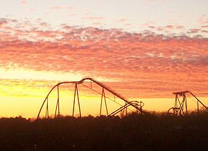
Busch Gardens Europe
Busch Gardens Williamsburg is a 383 acre theme park located in James City County, Virginia about 3 miles southeast of Williamsburg, originally developed by Anheuser-Busch and currently owned by SeaWorld Parks & Entertainment, a division of The Blackstone Group...
theme park, an office park, and the Kingsmill
Kingsmill
Kingsmill is a name which has been used in James City County, Virginia since the mid-18th century. Initially the name of a plantation, in modern times, the name is attached to a geographic area which includes a large planned residential community, a resort complex, a theme park, a brewery, and a...
resort and planned community
Planned community
A planned community, or planned city, is any community that was carefully planned from its inception and is typically constructed in a previously undeveloped area. This contrasts with settlements that evolve in a more ad hoc fashion. Land use conflicts are less frequent in planned communities since...
. Grove has attracted industrial development related to regional businesses.
Residential
Grove is largely a bedroom community. Housing in Grove is generally considered more affordable than in many other areas of the fast-growing James City County. Many families have lived there for generations. Housing consists of older detached single-family homeSingle-family home
A single-family detached home, also called a single-detached dwelling or separate house is a free-standing residential building. It is defined in opposition to a multi-family dwelling.- Definitions :...
s situated on lots, with many dating to the two world war periods of rapid growth, and a number of newer houses. The latter are both interspersed in older neighborhoods and concentrated in newer subdivisions. Several large condominium projects and mobile home
Mobile home
Mobile homes or static caravans are prefabricated homes built in factories, rather than on site, and then taken to the place where they will be occupied...
parks provide other choices. Two larger mobile home developments feature modern amenities, such as underground wiring, curbs and gutters, paved driveways, street lighting, and community playgrounds.
As of 2007, residential development continued with a new townhouse project, and many new detached single family homes. While the mobile home parks are not expanding, in some instances owners are replacing units with new or much newer mobile homes on the existing lots. Throughout Grove, there are few vacant lots for additional mobile homes.
Community facilities
James River Elementary School and James River Community Center are co-located in a modern complex. The school is a magnet schoolMagnet school
In education in the United States, magnet schools are public schools with specialized courses or curricula. "Magnet" refers to how the schools draw students from across the normal boundaries defined by authorities as school zones that feed into certain schools.There are magnet schools at the...
of the Williamsburg-James City County Public Schools
Williamsburg-James City County Public Schools
The Williamsburg-James City County Public Schools is a combined public school division which serves the independent city of Williamsburg and James City County in the Virginia Peninsula area of the Hampton Roads region in southeastern Virginia.The system consists approximately 10,000 students in 14...
(WJC) which offers the International Baccalaureate Primary Years Programme, one of only five such school
School
A school is an institution designed for the teaching of students under the direction of teachers. Most countries have systems of formal education, which is commonly compulsory. In these systems, students progress through a series of schools...
s in Virginia. http://www.ibo.org/school/search/index.cfm?programmes=PYP&country=US®ion=VA&find_schools=Find
There are five churches, two nursing homes, two day-care centers, and a fire station. The Grove Christian Outreach Center (GCOC) is an agency affiliated with Grove Community Church. Staffed by volunteers, GCOC assists with family needs and coordination of community resources, such as the local food bank.
Retail
Grove includes a small retail strip at its eastern end, the Windy Hill Shops, a convenience storeConvenience store
A convenience store, corner store, corner shop, commonly called a bodega in Spanish-speaking areas of the United States, is a small store or shop in a built up area that stocks a range of everyday items such as groceries, toiletries, alcoholic and soft drinks, and may also offer money order and...
with gasoline. A free-standing 7-11 store and a campground are on the north side of U.S. Route 60.
Industrial
Near Grove's eastern edge, on the south side of U.S. Route 60, the county's James River Enterprise Zone, an Urban Enterprise ZoneUrban Enterprise Zone
In the United States, Urban Enterprise Zones , also known as Enterprise Zones, are intended to encourage development in blighted neighborhoods through tax and regulatory relief to entrepreneurs and investors who launch businesses in the area. UEZs are areas where companies can locate free of...
is located. The 5.6 square mile (15 km²) area contains 2,400 acres (9.7 km²) planned and zoned for industrial uses. James City County is seeking additional industrial business in this prime area of the county. The sites within a designated "enterprise zone" offer state and local incentives to businesses that locate in those zones, invest and create jobs.
Since the James River Enterprise Zone's inception in 1996, James River Commerce Center and Greenmount industrial park
Industrial park
An industrial park is an area zoned and planned for the purpose of industrial development...
s have added tenants such as a Ball Manufacturing plant, an aluminum can plant which supplies Anheuser-Busch
Anheuser-Busch
Anheuser-Busch Companies, Inc. , is an American brewing company. The company operates 12 breweries in the United States and 18 in other countries. It was, until December 2009, also one of America's largest theme park operators; operating ten theme parks across the United States through the...
's Williamsburg brewery. A distribution center for Wal-Mart
Wal-Mart
Wal-Mart Stores, Inc. , branded as Walmart since 2008 and Wal-Mart before then, is an American public multinational corporation that runs chains of large discount department stores and warehouse stores. The company is the world's 18th largest public corporation, according to the Forbes Global 2000...
and a Haynes furniture warehouse are also located there. Recently, a masonry supply firm and a Volvo equipment rental facility have each announced plans to establish facilities. Carter Machinery Company, a Caterpillar dealership with 17 locations in Virginia and West Virginia, announced in May 2007 that it is building a new sales and service center on a 23 acres (93,077.8 m²) site. Additional sites are available for development.
U.S. Route 60 relocation project
For several years in the early 21st century, James City County has worked to improve US Route 60 between Grove and Newport News. Officials wanted to provide better access to Interstate 64Interstate 64 in Virginia
In the U.S. state of Virginia, Interstate 64 runs east–west through the middle of the state from West Virginia to the Hampton Roads region, a total of . It is notable for crossing the mouth of the harbor of Hampton Roads on the Hampton Roads Bridge-Tunnel, the first bridge-tunnel to...
from the industrial sites in Grove, which generate a considerable volume of truck traffic, and reduce the same on the existing roadway.
Access for the industrial traffic to I-64 requires a drive of about 4 miles (6.4 km) in either direction on two-lane sections of U.S. 60 at non-highway speeds through residential areas. They must share the road with local traffic and school bus
School bus
A school bus is a type of bus designed and manufactured for student transport: carrying children and teenagers to and from school and school events...
es serving either the James River Elementary School's county-wide magnet program or alternatively, the large elementary school in the Lee Hall community in neighboring Newport News.
In June 2007, Virginia's Commonwealth Transportation Board
Commonwealth Transportation Board
The Commonwealth Transportation Board, formerly the State Highway and Transportation Board, regulates and funds transportation in Virginia. It oversees the Virginia Department of Transportation.-Membership:The Board consists of seventeen members:...
approved a major portion of the funding needed for the U.S. Route 60 relocation project. The relocated divided highway will begin on its western end near the current intersection of Blow Flats Road. The new alignment will take it through the Greenmount Industrial Park to reach the Newport News city limits. There, a new crossing of Skiffe's Creek will be built. The remainder of the roadway will continue on a new alignment and effectively bypass the two-lane portion of U.S. Route 60 through the historic Lee Hall community. It will rejoin the current highway near the cloverleaf intersection of Fort Eustis Boulevard, where there is four-lane access close by to exit 250 of Interstate 64, as well as an extant four-lane section of U.S. Route 60. In separate projects, portions of Warwick Boulevard east of Fort Eustis in Newport News are being widened to six lanes. Fort Eustis Boulevard is also being widened to four lanes between Jefferson Avenue and U.S. Route 17
U.S. Route 17 in Virginia
U.S. Route 17 is a part of the U.S. Highway System that runs from Punta Gorda, Florida to Winchester, Virginia. In Virginia, the U.S. Highway runs from the North Carolina state line in Chesapeake north to its northern terminus at US 11, US 50, and US 522 in Winchester. US 17 is a major highway...
in Newport News and York County.
A similar roads issue was earlier visited in the 1930s, when the current parallel State Route 143 (Merrimack Trail
Merrimack Trail
Merrimack Trail is the local name for State Route 143 as it passes through portions of York County and James City County and the independent city of Williamsburg in the Virginia Peninsula subregion of Hampton Roads in Virginia.-History:...
) was built as part of a four-laned through-route alternative to U.S. 60 for increasing volumes of east-west through traffic in the area. Once again, plans have been made to preserve the two-lane, bucolic nature of Route 60 through the Grove and Lee Hall communities, and to avoid the major impact which would have resulted by widening the road through these historic communities.
Public transportation
There is little retail or tourist employment in Grove, especially since Carter's Grove Plantation closed in 2003. Many residents use the Williamsburg Area TransportWilliamsburg Area Transport
Williamsburg Area Transit Authority is a governmentally-operated agency which provides transit bus and paratransit services in the City of Williamsburg, James City County, and York County in the Historic Triangle area of the Virginia Peninsula subregion of Hampton Roads in southeastern...
(WAT) public bus system
Transit bus
A transit bus , also known as a commuter bus, city bus, or public bus, is a bus used for short-distance public transport purposes...
or its complementary paratransit
Paratransit
Paratransit is an alternative mode of flexible passenger transportation that does not follow fixed routes or schedules. Typically mini-buses are used to provide paratransit service, but also share taxis and jitneys are important providers....
service to reach employment, shopping, and other business at adjacent Busch Gardens Europe
Busch Gardens Europe
Busch Gardens Williamsburg is a 383 acre theme park located in James City County, Virginia about 3 miles southeast of Williamsburg, originally developed by Anheuser-Busch and currently owned by SeaWorld Parks & Entertainment, a division of The Blackstone Group...
, in downtown Williamsburg, and at businesses along the way, or to transfer to other routes in the WAT network through the system's hub at the Williamsburg Transportation Center. Amtrak
Amtrak
The National Railroad Passenger Corporation, doing business as Amtrak , is a government-owned corporation that was organized on May 1, 1971, to provide intercity passenger train service in the United States. "Amtrak" is a portmanteau of the words "America" and "track". It is headquartered at Union...
, Greyhound Lines
Greyhound Lines
Greyhound Lines, Inc., based in Dallas, Texas, is an intercity common carrier of passengers by bus serving over 3,700 destinations in the United States, Canada and Mexico, operating under the well-known logo of a leaping greyhound. It was founded in Hibbing, Minnesota, USA, in 1914 and...
, and Trailways services, as well as taxicab
Taxicab
A taxicab, also taxi or cab, is a type of vehicle for hire with a driver, used by a single passenger or small group of passengers, often for a non-shared ride. A taxicab conveys passengers between locations of their choice...
s and rental cars, are also located in Williamsburg.
The WAT bus route serving Grove leaves the Williamsburg Transportation Center on the hour and runs along U.S. Route 60 through the entire length of Grove. It continues east to serve the Wal-Mart distribution center, a Haynes furniture warehouse in the growing Green Mount industrial park
Industrial park
An industrial park is an area zoned and planned for the purpose of industrial development...
, and provides an hourly connection six days a week to the massive Hampton Roads Transit
Hampton Roads Transit
Hampton Roads Transit a.k.a. "HRT" formed in October 1999 by the voluntary merging of PENTRAN on the Virginia Peninsula and TRT Hampton Roads Transit a.k.a. "HRT" formed in October 1999 by the voluntary merging of PENTRAN (Peninsula Transportation District Commission) on the Virginia Peninsula and...
(HRT) system at the western edge of Newport News
Newport News, Virginia
Newport News is an independent city located in the Hampton Roads metropolitan area of Virginia. It is at the southeastern end of the Virginia Peninsula, on the north shore of the James River extending southeast from Skiffe's Creek along many miles of waterfront to the river's mouth at Newport News...
at Lee Hall
Lee Hall, Virginia
Lee Hall is a former unincorporated town long located in the former Warwick County. Since 1958, Lee Hall has been a suburban community in the extreme western portion of the independent city of Newport News in the Commonwealth of Virginia....
. The WAT bus stops on a side street adjacent to the local Food Lion and other stores, returning to Williamsburg via Grove with departures on the half hour.
The HRT system covers most of the other cities of Hampton Roads, with extensive networks in highly urbanized areas of Newport News, Hampton, and Norfolk. Some heavily patronized HRT routes trace their heritage to street railway lines started in the late 19th and early 20th centuries.
Notable residents and sites
- Dr. J. Blaine "Jim" BlaytonJ. Blaine BlaytonDr. James Blaine 'Jim' Blayton was a prominent African American physician in the Williamsburg, Virginia area who lived in the Grove Community in adjacent James City County. He practiced medicine for over 50 years, and was also a civic leader.-Early years:Blayton was born in Indian Territory in...
(1905-2002) was a prominent African American physician who practiced in the Williamsburg area.
- In 1963, Oscar H. Blayton (son of Dr. J. Blaine Blayton) became the first African American to attend the College of William and MaryCollege of William and MaryThe College of William & Mary in Virginia is a public research university located in Williamsburg, Virginia, United States...
as an undergraduate.
- Ron SpringsRon SpringsRonald Edward "Ron" Springs was a professional American football running back, who played eight seasons in the NFL, for the Dallas Cowboys from 1979–1984, followed by the Tampa Bay Buccaneers in 1985-1986. He is the father of NFL cornerback Shawn Springs...
, ex-Dallas Cowboys player.
- In the mid 1970s, the Busch Gardens Europe theme park, a large brewery, and the KingsmillKingsmillKingsmill is a name which has been used in James City County, Virginia since the mid-18th century. Initially the name of a plantation, in modern times, the name is attached to a geographic area which includes a large planned residential community, a resort complex, a theme park, a brewery, and a...
planned communityPlanned communityA planned community, or planned city, is any community that was carefully planned from its inception and is typically constructed in a previously undeveloped area. This contrasts with settlements that evolve in a more ad hoc fashion. Land use conflicts are less frequent in planned communities since...
and resort were developed by Anheuser-BuschAnheuser-BuschAnheuser-Busch Companies, Inc. , is an American brewing company. The company operates 12 breweries in the United States and 18 in other countries. It was, until December 2009, also one of America's largest theme park operators; operating ten theme parks across the United States through the...
Corporation.
- Grove Creek Natural Area is located on private property west of Carter's Grove Plantation. Although not open to the public, rare plants are located there.
See also
- Lost counties, cities and towns of Virginia
- Locust Grove, VirginiaLocust Grove, VirginiaLocust Grove is an unincorporated community in eastern Orange County, Virginia, United States. Its ZIP code is 22508; the population of the ZCTA for that ZIP code was 7,605 at the 2000 census...
- Sugar Grove, VirginiaSugar Grove, VirginiaSugar Grove is a census-designated place in Smyth County, Virginia, United States. The population was 741 at the 2000 census.-Geography:Sugar Grove is located at ....
Publications
- McCartney, Martha W. (1977) James City County: Keystone of the Commonwealth; James City County, Virginia; Donning and Company; ISBN 0-89865-999-X
External links
- "Cast Down Your Buckets Where You Are: An Ethnohistorical Study of the African-American Community on the Lands of the Yorktown Naval Weapons Station 1865-1918", Office of the Secretary of Defense
- "History", James City County, Virginia Official Website
- Williamsburg-James City County Public Schools
- Williamsburg Area Transport public bus and paratransit service
- Williamsburg Regional Library
- Grove Christian Outreach Center
- Grove Creek Natural Area, Virginia Natural Plant Society
- Skiffe's Creek Watershed