
Great Falls of the Missouri River
Encyclopedia
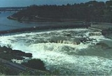
The Great Falls of the Missouri River are a series of waterfall
s on the Missouri River
in north-central Montana
in the United States
. The five falls, which are located in a 10 miles (16.1 km) area of the river, are:
The Missouri River drops a total of 612 feet (186.5 m) from the first of the falls to the last, which includes 187 feet (57 m) of waterfalls and 425 feet (129.5 m) of riverbed descent. The Great Falls have been described as "spectacular", one of the "scenic wonders of America", and "a major geographic discovery". Meriwether Lewis
said they were the grandest sight he'd beheld thus far in the journey of the Corps of Discovery
.
The Great Falls of the Missouri River were depicted on the Montana Territory
territorial seal, and became part of the State of Montana's state seal in 1893.
, however, had a formal name for Rainbow Falls, and called it "Napa's Snarl
ing." No record exists of a Native American
name for any of the other four waterfalls.
Four of the five waterfalls were given names in 1805 by American
explorers Meriwether Lewis
and William Clark. Both Meriwether Lewis and William Clark named Crooked Falls in their journals. Clark named three of the remaining waterfalls on his map: "Great Falls" (which retains its name to this day), "Beautiful Cascade" (now called Rainbow Falls), and "Upper Pitch" (now known as Black Eagle Falls). "Beautiful Cascade" was renamed "Rainbow Falls" in 1872 by Thomas B. Rogers, an engineer with the Great Northern Railway. Colter Falls received its name from Paris Gibson
, in honor of John Colter
(a member of the Lewis and Clark Expedition
). Black Eagle Falls is named for the black eagle which built a nest in a cottonwood tree on an island in the middle of the falls. It is not clear when the falls lost their original name of "Upper Pitch," but they had acquired their modern name by at least 1877.
, an intracontinental shear zone between two geologic province
s of basement rock
of the Archean
period which form part of the North American continent
, the Hearne province and Wyoming province
. Approximately 1.5 million years ago, the Missouri River, the Yellowstone River
and Musselshell River
all flowed northward into a terminal lake. During the last glacial period, the Laurentide
and Cordilleran
ice sheets pushed these lakes and rivers southward. Between 15,000 BCE
and 11,000 BCE, the Laurentide ice sheet blocked the Missouri River and created Glacial Lake Great Falls
. About 13,000 BCE, as the glacier retreated, Glacial Lake Great Falls emptied catastrophically in a glacial lake outburst flood
. The current course of the Missouri River essentially marks the southern boundary of the Laurentide ice sheet. The Missouri, Yellowstone, and Musselshell rivers flowed eastward around the glacial mass, eventually settling into their present courses. As the ice retreated, meltwater poured through Highwood Mountains
and eroded the mile-long, 500 feet (152.4 m) Shonkin Sag
—one of the most famous prehistoric meltwater channels in the world.
The Great Falls themselves formed on a fall line
unconformity
in the Great Falls Tectonic Zone. The Missouri River settled into a bedrock canyon which lay beneath the clay laid down by Glacial Lake Great Falls. The course of the Missouri in and around the Great Falls has changed very little since then, in comparison to lower regions of the river on the ground moraine that forms much of the upper Great Plains.
The Great Falls of the Missouri River formed because the Missouri is flowing over and through the Kootenai Formation
, a mostly nonmarine sandstone
laid down by rivers, glaciers, and lakes in the past. Some of the Kootenai Formation is marine, however, laid down by shallow seas. The river is eating away at the softer nonmarine sandstone, with the harder rock forming the falls themselves. Until relatively recently (in geologic time) the Missouri River in the area had a much wider channel, but it has now settled into its current course, where it will continue to cut more deeply into the sandstone.
would often hunt bison in the area on a seasonal basis, but no permanent settlements existed near the Great Falls for much of prehistory
. Around 1600, Piegan Blackfoot Indians, migrating west, entered the area, pushing the Salish back into the Rocky Mountains
and claiming the area as their own. The Great Falls of the Missouri remained in the tribal territory of the Blackfeet until Americans claimed the region in 1803
.
Although the discovery of the Great Falls by Native Americans is not recorded, the South Piegan Blackfoot were well-acquainted with the Great Falls by the late 18th century, and news of the cataracts had spread among native peoples as far east as central North Dakota
.
(which claimed the area despite Native American habitation) in 1803, as part of the Louisiana Purchase
. Thomas Jefferson
, then President of the United States
, had long desired to send an expedition into the area. Jefferson sought and won permission and funding for an expedition from Congress
in January 1803. On May 14, 1804, the Lewis and Clark Expedition
departed St. Louis, Missouri
, to map the course of the Missouri River; establish whether a river route to the Pacific Ocean
existed; study the Indian tribes
, botany
, geology
, terrain
and wildlife in the region; and evaluate whether British
and French Canadian
hunters and trappers in the area posed a challenge to American control over the region. Expedition leaders Meriwether Lewis and William Clark first learned of the "great falls" from the Mandan Indians while wintering at Fort Mandan
from November 2, 1804, until April 7, 1805.
The Lewis and Clark Expedition discovered the Great Falls of the Missouri on June 13, 1805. Meriwether Lewis was the first white person to see the falls. Lewis described the encounter in a now-famous passage of his expedition diary:
The falls which Lewis had seen were the Great Falls. Exploring the following day, Lewis discovered Crooked Falls, Rainbow Falls, Colter Falls, and Black Eagle Falls. At the final waterfalls, Lewis saw an amazing site:
Mounting a hill near Black Eagle Falls (probably where the town of Black Eagle
is today), Lewis saw that the cataracts ended and that another large river joined the Missouri about two and a half miles further upstream. Although it was very late in the afternoon, Lewis rushed forward to see this river, and was attacked by a grizzly bear
. He ran more than 80 yards and launched himself into the Missouri River, and luckily the bear did not follow. The Lewis and Clark Expedition was forced to portage
around the Great Falls, an arduous task that took nearly a month.
York, an African American
slave owned by William Clark and who had participated in the Expedition, was the first black American to see the Great Falls.
 The Lewis and Clark Expedition made a number of discoveries near the Great Falls. On June 13, Silas Goodrich caught numerous Westslope cutthroat trout
at the falls, the first time anyone in the expedition had seen these fish, and several samples were preserved which constituted the type specimens
for the fish. The trout was subsequently given the scientific name "Oncorhynchus clarki lewisi" in honor of the expedition leaders. The Westslope cutthroat is now the "official state fish" of Montana. The explorers also collected the first sample of the gumbo evening primrose
and Western Meadowlark
at the Great Falls.
On June 18, while reconnoitering the series of falls on the south side of the Missouri River with a group of five others, William Clark discovered Giant Springs
—which he correctly judged to be the largest spring in the world. He was the first white person to see the springs, and the first white person to see the falls from the south side of the Missouri.
Meriwether Lewis revisited the Great Falls on July 11, 1806, as the Corps of Discovery returned east. Lewis and nine men stopped at the Great Falls with the intention of exploring the Marias River
and discovering its source. But during the night, Indians stole half the party's 17 horses, forcing three of the men to stay behind.
reached them in 1822. White people next visited the Great Falls when Bridger and Major Andrew Henry
led a fur-trading expedition there in April 1823 (and were attacked by Blackfeet Indians while camping at the site). British explorer Alexander Ross
trapped around the Great Falls in 1824. In 1838, a mapping expedition sent by the U.S. federal government and guided by Bridger spent four years in the area. Margaret Harkness Woodman became first white woman to see the Great Falls in 1862.
The first permanent settlement near the Great Falls was Fort Benton
, established in 1846 about 40 miles (64.4 km) downstream from the Great Falls. The Great Falls marked the limit of the navigable section of the Missouri River, and the first steamboat
arrived at the falls in 1859. In 1860, the Mullan Road
linked Fort Benton with Fort Walla Walla
in the Washington Territory
.
Politically, the Great Falls of the Missouri River passed through numerous hands in the 19th century. It was part of the unincorporated frontier
until May 30, 1854, when Congress established the Nebraska Territory
. Indian attacks on white explorers and settlers dropped significantly after Isaac Stevens
negotiated the Treaty of Hellgate
in 1855, and white settlement in the area began to occur. On March 2, 1861, it became part of the Dakota Territory
. The Great Falls were incorporated into the Idaho Territory
on March 4, 1863, and then into the Montana Territory
on May 28, 1864. It became part of the state of Montana upon that territory's admission to statehood on November 8, 1889.
The Great Falls of the Missouri River became the site of a permanent settlement in 1883. Businessman
Paris Gibson
visited the Great Falls in 1880, and was deeply impressed by the possibilities for building a major industrial city near the falls with power provided by hydroelectricity
. He returned in 1883 with surveyors and plat
ted a city (to be named Great Falls) on the south side of the river. The city's first citizen, Silas Beachley, arrived later that year. With investments from railroad owner James J. Hill and Helena
businessman C. A. Broadwater
, houses, a store, and a flour mill were established in 1884. A planing mill
, lumber yard, bank, school, and newspaper were established in 1885. By 1887 the town had 1,200 citizens, and in October of that year the Great Northern Railway arrived in the city. Great Falls, Montana
, was incorporated on November 28, 1888, Black Eagle Dam was built in 1890, and by 1912 Rainbow Dam and Volta Dam (now Ryan Dam) were all operating.
The city of Great Falls, Montana
, derives its name from the waterfalls. The small town of Black Eagle, Montana
, derives its name from Black Eagle Falls, and Cascade County
(in which both are located) is named for the cataracts and rapids which make up the falls.
Rainbow Falls was dammed in 1910 when Rainbow Dam was built. The reservoir behind the dam submerged Colter Falls.
Volta Dam was built on top of the Great Falls in 1915, and later renamed Ryan Dam in 1940 in honor of John D. Ryan
, the president and founder of the Montana Power Company
.
Crooked Falls is the only waterfall in the area which is in its original state as of 2009.
since 1966. The Great Falls are also part of the Lewis and Clark National Historic Trail
, established by Congress in 1978.
The Lewis and Clark National Historic Trail Interpretive Center was built in 1998 on cliff overlooking the Missouri River near Crooked Falls. It provides an extensive look into Lewis and Clark's discovery of the Great Falls and their portage around them, as well as exhibits on native peoples of the area.
In 1989, the City of Great Falls, the Montana Department of Fish, Wildlife and Parks
, and other public and private bodies established the River's Edge Trail, a 30 miles (48.3 km) series of paved and unpaved trails that follow the Great Falls as well as the Lewis and Clark Expedition portage route (along with other scenic and historic area of the City of Great Falls and town of Black Eagle).
engraver John James Barrelet to make drawings of the Great Falls. After Lewis' death in 1810, William Clark visited Lewis' home and found the drawings, but they have since disappeared.
The Great Falls have been depicted in well-known paintings over the years. The waterfalls may be seen in the background of John Mix Stanley
's large painting "Barter for a Bride" (originally titled "A Family Group"), which was painted some time between 1854 and 1863 and now hangs in the Diplomatic Reception Room in the United States Department of State
in Washington, D.C.
The noted Western painter O. C. Seltzer depicted the cataracts in his 1927 work, "Lewis and Clark With Sacajawea at the Great Falls of the Missouri, 1804."
The first known photograph of the Great Falls was taken by noted Western photographer James D. Hutton
about 1859 or 1860.
Waterfall
A waterfall is a place where flowing water rapidly drops in elevation as it flows over a steep region or a cliff.-Formation:Waterfalls are commonly formed when a river is young. At these times the channel is often narrow and deep. When the river courses over resistant bedrock, erosion happens...
s on the Missouri River
Missouri River
The Missouri River flows through the central United States, and is a tributary of the Mississippi River. It is the longest river in North America and drains the third largest area, though only the thirteenth largest by discharge. The Missouri's watershed encompasses most of the American Great...
in north-central Montana
Montana
Montana is a state in the Western United States. The western third of Montana contains numerous mountain ranges. Smaller, "island ranges" are found in the central third of the state, for a total of 77 named ranges of the Rocky Mountains. This geographical fact is reflected in the state's name,...
in the United States
United States
The United States of America is a federal constitutional republic comprising fifty states and a federal district...
. The five falls, which are located in a 10 miles (16.1 km) area of the river, are:
- Black Eagle Falls (26 in 5 in or 8.05 m);
- Colter FallsColter FallsColter Falls, also Coulter Falls, waterfall, nearly in width, part of the Great Falls of the Missouri, on the Missouri River in north-central Montana. Downstream of Colter Falls lies Rainbow Falls, and upstream is Black Eagle Falls. The Lewis and Clark Expedition was known to discover Westslope...
(6 in 7 in or 2.01 m); - Rainbow FallsRainbow Falls (Missouri River)Rainbow Falls is a waterfall on the Missouri River in Great Falls, Montana, just upstream from Crooked Falls and downstream from Colter Falls and Rainbow Dam. It is 47 feet high and 1,320 feet wide. The waterfall is part of the five Great Falls of the Missouri...
(44 in 6 in or 13.56 m); - Crooked Falls, also known as Horseshoe Falls (19 feet or 5.79 m); and
- The Great Falls (87 feet or 26.52 m).
The Missouri River drops a total of 612 feet (186.5 m) from the first of the falls to the last, which includes 187 feet (57 m) of waterfalls and 425 feet (129.5 m) of riverbed descent. The Great Falls have been described as "spectacular", one of the "scenic wonders of America", and "a major geographic discovery". Meriwether Lewis
Meriwether Lewis
Meriwether Lewis was an American explorer, soldier, and public administrator, best known for his role as the leader of the Lewis and Clark Expedition also known as the Corps of Discovery, with William Clark...
said they were the grandest sight he'd beheld thus far in the journey of the Corps of Discovery
Lewis and Clark Expedition
The Lewis and Clark Expedition, or ″Corps of Discovery Expedition" was the first transcontinental expedition to the Pacific Coast by the United States. Commissioned by President Thomas Jefferson and led by two Virginia-born veterans of Indian wars in the Ohio Valley, Meriwether Lewis and William...
.
The Great Falls of the Missouri River were depicted on the Montana Territory
Montana Territory
The Territory of Montana was an organized incorporated territory of the United States that existed from May 28, 1864, until November 8, 1889, when it was admitted to the Union as the State of Montana.-History:...
territorial seal, and became part of the State of Montana's state seal in 1893.
Names of the Great Falls
The Mandan Indians knew of the cataracts, and called them by a descriptive (but not formal) name "Minni-Sose-Tanka-Kun-Ya" or "the great falls." The South Piegan BlackfeetBlackfeet
The Piegan Blackfeet are a tribe of Native Americans of the Algonquian language family based in Montana, having lived in this area since around 6,500 BC. Many members of the tribe live as part of the Blackfeet Nation in northwestern Montana, with population centered in Browning...
, however, had a formal name for Rainbow Falls, and called it "Napa's Snarl
Snarl
A snarl is a facial expression, where the upper lip is raised, and the nostrils widen, generally indicating hate, anger or pain. In addition to humans, other mammals including monkeys and dogs snarl, often to warn others of their potential bite. In humans, snarling uses the levator labii...
ing." No record exists of a Native American
Native Americans in the United States
Native Americans in the United States are the indigenous peoples in North America within the boundaries of the present-day continental United States, parts of Alaska, and the island state of Hawaii. They are composed of numerous, distinct tribes, states, and ethnic groups, many of which survive as...
name for any of the other four waterfalls.
Four of the five waterfalls were given names in 1805 by American
United States
The United States of America is a federal constitutional republic comprising fifty states and a federal district...
explorers Meriwether Lewis
Meriwether Lewis
Meriwether Lewis was an American explorer, soldier, and public administrator, best known for his role as the leader of the Lewis and Clark Expedition also known as the Corps of Discovery, with William Clark...
and William Clark. Both Meriwether Lewis and William Clark named Crooked Falls in their journals. Clark named three of the remaining waterfalls on his map: "Great Falls" (which retains its name to this day), "Beautiful Cascade" (now called Rainbow Falls), and "Upper Pitch" (now known as Black Eagle Falls). "Beautiful Cascade" was renamed "Rainbow Falls" in 1872 by Thomas B. Rogers, an engineer with the Great Northern Railway. Colter Falls received its name from Paris Gibson
Paris Gibson
Paris Gibson was an American entrepreneur and politician.Gibson was born in Brownfield, Maine. An 1851 graduate of Bowdoin College, he served as a member of the Montana State Senate and as a Democratic member of the United States Senate between 1901 and 1905.-Career:In 1853 he was elected to the...
, in honor of John Colter
John Colter
John Colter was a member of the Lewis and Clark Expedition . Though party to one of the more famous expeditions in history, Colter is best remembered for explorations he made during the winter of 1807–1808, when Colter became the first known person of European descent to enter the region now known...
(a member of the Lewis and Clark Expedition
Lewis and Clark Expedition
The Lewis and Clark Expedition, or ″Corps of Discovery Expedition" was the first transcontinental expedition to the Pacific Coast by the United States. Commissioned by President Thomas Jefferson and led by two Virginia-born veterans of Indian wars in the Ohio Valley, Meriwether Lewis and William...
). Black Eagle Falls is named for the black eagle which built a nest in a cottonwood tree on an island in the middle of the falls. It is not clear when the falls lost their original name of "Upper Pitch," but they had acquired their modern name by at least 1877.
Geological history
The Missouri River lies atop the Great Falls Tectonic ZoneGreat Falls Tectonic Zone
The Great Falls Tectonic Zone is a major intracontinental shear zone between the Hearne craton and Wyoming craton, basement rock of the Archean Eon which form part of the North American continent. The zone is an area about 100 miles wide extending from the southwestern Idaho-Montana border across...
, an intracontinental shear zone between two geologic province
Geologic province
A geologic or geomorphic province is a spatial entity with common geologic or geomorphic attributes. A province may include a single dominant structural element such as a basin or a fold belt, or a number of contiguous related elements...
s of basement rock
Basement (geology)
In geology, the terms basement and crystalline basement are used to define the rocks below a sedimentary platform or cover, or more generally any rock below sedimentary rocks or sedimentary basins that are metamorphic or igneous in origin...
of the Archean
Archean
The Archean , also spelled Archeozoic or Archæozoic) is a geologic eon before the Paleoproterozoic Era of the Proterozoic Eon, before 2.5 Ga ago. Instead of being based on stratigraphy, this date is defined chronometrically...
period which form part of the North American continent
Continent
A continent is one of several very large landmasses on Earth. They are generally identified by convention rather than any strict criteria, with seven regions commonly regarded as continents—they are : Asia, Africa, North America, South America, Antarctica, Europe, and Australia.Plate tectonics is...
, the Hearne province and Wyoming province
Wyoming craton
The Wyoming craton is a craton located in the west-central United States and western Canada – more specifically, in Montana, Wyoming, southern Alberta, southern Saskatchewan, and parts of northern Utah...
. Approximately 1.5 million years ago, the Missouri River, the Yellowstone River
Yellowstone River
The Yellowstone River is a tributary of the Missouri River, approximately long, in the western United States. Considered the principal tributary of the upper Missouri, the river and its tributaries drain a wide area stretching from the Rocky Mountains in the vicinity of the Yellowstone National...
and Musselshell River
Musselshell River
The Musselshell River is a tributary of the Missouri River, long from its origins at the confluence of its North and South Forks near Martinsdale, Montana to its mouth on the Missouri River. It is located east of the Continental divide entirely within Montana in the United States...
all flowed northward into a terminal lake. During the last glacial period, the Laurentide
Laurentide ice sheet
The Laurentide Ice Sheet was a massive sheet of ice that covered hundreds of thousands of square miles, including most of Canada and a large portion of the northern United States, multiple times during Quaternary glacial epochs. It last covered most of northern North America between c. 95,000 and...
and Cordilleran
Cordilleran Ice Sheet
The Cordilleran ice sheet was a major ice sheet that covered, during glacial periods of the Quaternary, a large area of North America. This included the following areas:*Western Montana*The Idaho Panhandle...
ice sheets pushed these lakes and rivers southward. Between 15,000 BCE
Common Era
Common Era ,abbreviated as CE, is an alternative designation for the calendar era originally introduced by Dionysius Exiguus in the 6th century, traditionally identified with Anno Domini .Dates before the year 1 CE are indicated by the usage of BCE, short for Before the Common Era Common Era...
and 11,000 BCE, the Laurentide ice sheet blocked the Missouri River and created Glacial Lake Great Falls
Glacial Lake Great Falls
Glacial Lake Great Falls was a prehistoric proglacial lake which existed in what is now central Montana in the United States between 15,000 BCE and 11,000 BCE. Centered on the modern city of Great Falls, Montana, Glacial Lake Great Falls extended as far north as Cut Bank, Montana, and as far south...
. About 13,000 BCE, as the glacier retreated, Glacial Lake Great Falls emptied catastrophically in a glacial lake outburst flood
Glacial lake outburst flood
A glacial lake outburst flood is a type of outburst flood that occurs when the dam containing a glacial lake fails. The dam can consist of glacier ice or a terminal moraine...
. The current course of the Missouri River essentially marks the southern boundary of the Laurentide ice sheet. The Missouri, Yellowstone, and Musselshell rivers flowed eastward around the glacial mass, eventually settling into their present courses. As the ice retreated, meltwater poured through Highwood Mountains
Highwood Mountains
The Highwood Mountains cover approximately 4,659 km² in north central Montana in the U.S., east of Great Falls and Benton Lake National Wildlife Refuge, at the northern end of the Lewis and Clark National Forest...
and eroded the mile-long, 500 feet (152.4 m) Shonkin Sag
Shonkin Sag
The Shonkin Sag is a prehistoric fluvioglacial landform located along the northern edge of the Highwood Mountains in the state of Montana in the United States. The Sag is a river channel formed by the Missouri River and glacial meltwater pouring from Glacial Lake Great Falls...
—one of the most famous prehistoric meltwater channels in the world.
The Great Falls themselves formed on a fall line
Fall line
A fall line is a geomorphologic unconformity between an upland region of relatively hard crystalline basement rock and a coastal plain of softer sedimentary rock. A fall line is typically prominent when crossed by a river, for there will often be rapids or waterfalls...
unconformity
Unconformity
An unconformity is a buried erosion surface separating two rock masses or strata of different ages, indicating that sediment deposition was not continuous. In general, the older layer was exposed to erosion for an interval of time before deposition of the younger, but the term is used to describe...
in the Great Falls Tectonic Zone. The Missouri River settled into a bedrock canyon which lay beneath the clay laid down by Glacial Lake Great Falls. The course of the Missouri in and around the Great Falls has changed very little since then, in comparison to lower regions of the river on the ground moraine that forms much of the upper Great Plains.
The Great Falls of the Missouri River formed because the Missouri is flowing over and through the Kootenai Formation
Kootenai Formation
The Kootenai Formation is a Mesozoic geologic formation. Dinosaur remains are among the fossils that have been recovered from the formation, although none have yet been referred to a specific genus.-See also:* List of dinosaur-bearing rock formations...
, a mostly nonmarine sandstone
Sandstone
Sandstone is a sedimentary rock composed mainly of sand-sized minerals or rock grains.Most sandstone is composed of quartz and/or feldspar because these are the most common minerals in the Earth's crust. Like sand, sandstone may be any colour, but the most common colours are tan, brown, yellow,...
laid down by rivers, glaciers, and lakes in the past. Some of the Kootenai Formation is marine, however, laid down by shallow seas. The river is eating away at the softer nonmarine sandstone, with the harder rock forming the falls themselves. Until relatively recently (in geologic time) the Missouri River in the area had a much wider channel, but it has now settled into its current course, where it will continue to cut more deeply into the sandstone.
Early inhabitants
The first human beings to see the Great Falls were Paleo-Indians who migrated into the area between 9,500 BCE and 8,270 BCE. The earliest inhabitants of North America entered Montana east of the Continental Divide between the Cordilleran and Laurentide ice sheets. The area remained only sparsely inhabited, however. Salish IndiansConfederated Salish and Kootenai Tribes of the Flathead Nation
The Confederated Salish and Kootenai Tribes of the Flathead Reservation are the Bitterroot Salish, Kootenai and Pend d'Oreilles Tribes. The Flatheads lived between the Cascade Mountains and Rocky Mountains. The Salish initially lived entirely east of the Continental Divide but established their...
would often hunt bison in the area on a seasonal basis, but no permanent settlements existed near the Great Falls for much of prehistory
Prehistory
Prehistory is the span of time before recorded history. Prehistory can refer to the period of human existence before the availability of those written records with which recorded history begins. More broadly, it refers to all the time preceding human existence and the invention of writing...
. Around 1600, Piegan Blackfoot Indians, migrating west, entered the area, pushing the Salish back into the Rocky Mountains
Rocky Mountains
The Rocky Mountains are a major mountain range in western North America. The Rocky Mountains stretch more than from the northernmost part of British Columbia, in western Canada, to New Mexico, in the southwestern United States...
and claiming the area as their own. The Great Falls of the Missouri remained in the tribal territory of the Blackfeet until Americans claimed the region in 1803
Louisiana Purchase
The Louisiana Purchase was the acquisition by the United States of America of of France's claim to the territory of Louisiana in 1803. The U.S...
.
Although the discovery of the Great Falls by Native Americans is not recorded, the South Piegan Blackfoot were well-acquainted with the Great Falls by the late 18th century, and news of the cataracts had spread among native peoples as far east as central North Dakota
North Dakota
North Dakota is a state located in the Midwestern region of the United States of America, along the Canadian border. The state is bordered by Canada to the north, Minnesota to the east, South Dakota to the south and Montana to the west. North Dakota is the 19th-largest state by area in the U.S....
.
Lewis and Clark
The United States purchased the area around the Great Falls of the Missouri from FranceFrance
The French Republic , The French Republic , The French Republic , (commonly known as France , is a unitary semi-presidential republic in Western Europe with several overseas territories and islands located on other continents and in the Indian, Pacific, and Atlantic oceans. Metropolitan France...
(which claimed the area despite Native American habitation) in 1803, as part of the Louisiana Purchase
Louisiana Purchase
The Louisiana Purchase was the acquisition by the United States of America of of France's claim to the territory of Louisiana in 1803. The U.S...
. Thomas Jefferson
Thomas Jefferson
Thomas Jefferson was the principal author of the United States Declaration of Independence and the Statute of Virginia for Religious Freedom , the third President of the United States and founder of the University of Virginia...
, then President of the United States
President of the United States
The President of the United States of America is the head of state and head of government of the United States. The president leads the executive branch of the federal government and is the commander-in-chief of the United States Armed Forces....
, had long desired to send an expedition into the area. Jefferson sought and won permission and funding for an expedition from Congress
United States Congress
The United States Congress is the bicameral legislature of the federal government of the United States, consisting of the Senate and the House of Representatives. The Congress meets in the United States Capitol in Washington, D.C....
in January 1803. On May 14, 1804, the Lewis and Clark Expedition
Lewis and Clark Expedition
The Lewis and Clark Expedition, or ″Corps of Discovery Expedition" was the first transcontinental expedition to the Pacific Coast by the United States. Commissioned by President Thomas Jefferson and led by two Virginia-born veterans of Indian wars in the Ohio Valley, Meriwether Lewis and William...
departed St. Louis, Missouri
St. Louis, Missouri
St. Louis is an independent city on the eastern border of Missouri, United States. With a population of 319,294, it was the 58th-largest U.S. city at the 2010 U.S. Census. The Greater St...
, to map the course of the Missouri River; establish whether a river route to the Pacific Ocean
Pacific Ocean
The Pacific Ocean is the largest of the Earth's oceanic divisions. It extends from the Arctic in the north to the Southern Ocean in the south, bounded by Asia and Australia in the west, and the Americas in the east.At 165.2 million square kilometres in area, this largest division of the World...
existed; study the Indian tribes
Native Americans in the United States
Native Americans in the United States are the indigenous peoples in North America within the boundaries of the present-day continental United States, parts of Alaska, and the island state of Hawaii. They are composed of numerous, distinct tribes, states, and ethnic groups, many of which survive as...
, botany
Botany
Botany, plant science, or plant biology is a branch of biology that involves the scientific study of plant life. Traditionally, botany also included the study of fungi, algae and viruses...
, geology
Geology
Geology is the science comprising the study of solid Earth, the rocks of which it is composed, and the processes by which it evolves. Geology gives insight into the history of the Earth, as it provides the primary evidence for plate tectonics, the evolutionary history of life, and past climates...
, terrain
Terrain
Terrain, or land relief, is the vertical and horizontal dimension of land surface. When relief is described underwater, the term bathymetry is used...
and wildlife in the region; and evaluate whether British
United Kingdom of Great Britain and Ireland
The United Kingdom of Great Britain and Ireland was the formal name of the United Kingdom during the period when what is now the Republic of Ireland formed a part of it....
and French Canadian
French Canadian
French Canadian or Francophone Canadian, , generally refers to the descendents of French colonists who arrived in New France in the 17th and 18th centuries...
hunters and trappers in the area posed a challenge to American control over the region. Expedition leaders Meriwether Lewis and William Clark first learned of the "great falls" from the Mandan Indians while wintering at Fort Mandan
Fort Mandan
Fort Mandan was the name of the encampment at which the Lewis and Clark Expedition wintered in 1804-1805. The encampment was located on the Missouri River approximately twelve miles from Washburn, North Dakota, though the precise location is not known for certain and may be under the nearby...
from November 2, 1804, until April 7, 1805.
The Lewis and Clark Expedition discovered the Great Falls of the Missouri on June 13, 1805. Meriwether Lewis was the first white person to see the falls. Lewis described the encounter in a now-famous passage of his expedition diary:
- ...my ears were saluted with the agreeable sound of a fall of water and advancing a little further I saw the spray arrise above the plain like a collumn of smoke which would frequently dispear again in an instant caused I presume by the wind which blew pretty hard from the S. W. I did not however loose my direction to this point which soon began to make a roaring too tremendious to be mistaken for any cause short of the great falls of the Missouri. ... I hurryed down the hill which was about 200 feet high and difficult of access, to gaze on this sublimely grand specticle. ... immediately at the cascade the river is about 300 yds. wide; about ninty or a hundred yards of this next the Lard. bluff is a smoth even sheet of water falling over a precipice of at least eighty feet, the remaining part of about 200 yards on my right formes the grandest sight I ever beheld, the hight of the fall is the same of the other but the irregular and somewhat projecting rocks below receives the water in it's passage down and brakes it into a perfect white foam which assumes a thousand forms in a moment sometimes flying up in jets of sparkling foam to the hight of fifteen or twenty feet and are scarcely formed before large roling bodies of the same beaten and foaming water is thrown over and conceals them. in short the rocks seem to be most happily fixed to present a sheet of the whitest beaten froath for 200 yards in length and about 80 feet perpendicular. the water after descending strikes against the butment before mentioned or that on which I stand and seems to reverberate and being met by the more impetuous courant they role and swell into half formed billows of great hight which rise and again disappear in an instant. this butment of rock defends a handsom little bottom of about three acres which is deversified and agreeably shaded with some cottonwood trees; in the lower extremity of the bottom there is a very thick grove of the same kind of trees which are small, in this wood there are several Indian lodges formed of sticks. ... from the reflection of the sun on the spray or mist which arrises from these falls there is a beatifull rainbow produced which adds not a little to the beauty of this majestically grand senery. after wrighting this imperfect discription I again viewed the falls and was so much disgusted with the imperfect idea which it conveyed of the scene that I determined to draw my pen across it and begin agin, but then reflected that I could not perhaps succeed better than pening the first impressions of the mind; I wished for the pencil of Salvator Rosa or the pen of Thompson, that I might be enabled to give to the enlightened world some just idea of this truly magnifficent and sublimely grand object, which has from the commencement of time been concealed from the view of civilized man; but this was fruitless and vain. I most sincerely regreted that I had not brought a crimee obscuraCamera obscuraThe camera obscura is an optical device that projects an image of its surroundings on a screen. It is used in drawing and for entertainment, and was one of the inventions that led to photography. The device consists of a box or room with a hole in one side...
with me by the assistance of which even I could have hoped to have done better but alas this was also out of my reach; I therefore with the assistance of my pen only indeavoured to traces some of the stronger features of this seen by the assistance of which and my recollection aided by some able pencil I hope still to give to the world some faint idea of an object which at this moment fills me with such pleasure and astonishment, and which of it's kind I will venture to ascert is second to but one in the known world. ...
The falls which Lewis had seen were the Great Falls. Exploring the following day, Lewis discovered Crooked Falls, Rainbow Falls, Colter Falls, and Black Eagle Falls. At the final waterfalls, Lewis saw an amazing site:
- I arrived at another cataract of 26 feet. ... below this fall at a little distance a beatifull little Island well timbered is situated about the middle of the river. in this Island on a Cottonwood tree an Eagle has placed her nest; a more inaccessible spot I believe she could not have found; for neither man nor beast dare pass those gulphs which separate her little domain from the shores. the water is also broken in such manner as it decends over this pitch that the mist or sprey rises to a considerable hight. this fall is certainly much the greatest I ever behald except those two which I have mentioned below. it is incomparably a greater cataract and a more noble interesting object than the celibrated falls of Potomac or SoolkilnSchuylkill RiverThe Schuylkill River is a river in Pennsylvania. It is a designated Pennsylvania Scenic River.The river is about long. Its watershed of about lies entirely within the state of Pennsylvania. The source of its eastern branch is in the Appalachian Mountains at Tuscarora Springs, near Tamaqua in...
&c.
Mounting a hill near Black Eagle Falls (probably where the town of Black Eagle
Black Eagle, Montana
Black Eagle is a census-designated place in Cascade County, Montana, United States. The population was 914 at the 2000 census. It is part of the 'Great Falls, Montana Metropolitan Statistical Area'.-Geography:...
is today), Lewis saw that the cataracts ended and that another large river joined the Missouri about two and a half miles further upstream. Although it was very late in the afternoon, Lewis rushed forward to see this river, and was attacked by a grizzly bear
Grizzly Bear
The grizzly bear , also known as the silvertip bear, the grizzly, or the North American brown bear, is a subspecies of brown bear that generally lives in the uplands of western North America...
. He ran more than 80 yards and launched himself into the Missouri River, and luckily the bear did not follow. The Lewis and Clark Expedition was forced to portage
Portage
Portage or portaging refers to the practice of carrying watercraft or cargo over land to avoid river obstacles, or between two bodies of water. A place where this carrying occurs is also called a portage; a person doing the carrying is called a porter.The English word portage is derived from the...
around the Great Falls, an arduous task that took nearly a month.
York, an African American
African American
African Americans are citizens or residents of the United States who have at least partial ancestry from any of the native populations of Sub-Saharan Africa and are the direct descendants of enslaved Africans within the boundaries of the present United States...
slave owned by William Clark and who had participated in the Expedition, was the first black American to see the Great Falls.
Westslope cutthroat trout
The westslope cutthroat trout , also known as the blackspotted cutthroat, is a subspecies of the cutthroat trout and is a freshwater fish in the salmon family of order Salmoniformes. The cutthroat is the Montana state fish...
at the falls, the first time anyone in the expedition had seen these fish, and several samples were preserved which constituted the type specimens
Biological type
In biology, a type is one particular specimen of an organism to which the scientific name of that organism is formally attached...
for the fish. The trout was subsequently given the scientific name "Oncorhynchus clarki lewisi" in honor of the expedition leaders. The Westslope cutthroat is now the "official state fish" of Montana. The explorers also collected the first sample of the gumbo evening primrose
Oenothera caespitosa
Oenothera caespitosa, known commonly as tufted evening primrose and fragrant evening primrose, is a perennial plant of the genus Oenothera native to much of western and central North America...
and Western Meadowlark
Western Meadowlark
Not to be confused with Eastern MeadowlarkThe Western Meadowlark is a medium-sized icterid bird, about 8.5 in long. It nests on the ground in open country in western and central North America. It feeds mostly on insects, but also seeds and berries...
at the Great Falls.
On June 18, while reconnoitering the series of falls on the south side of the Missouri River with a group of five others, William Clark discovered Giant Springs
Giant Springs
Giant Springs is a large first magnitude spring located near Great Falls, Montana. Its water has a temperature of 54o F and originates from snowmelt in the Little Belt Mountains, away...
—which he correctly judged to be the largest spring in the world. He was the first white person to see the springs, and the first white person to see the falls from the south side of the Missouri.
Meriwether Lewis revisited the Great Falls on July 11, 1806, as the Corps of Discovery returned east. Lewis and nine men stopped at the Great Falls with the intention of exploring the Marias River
Marias River
The Marias River is a tributary of the Missouri River, approximately 210 mi long, in the U.S. state of Montana. It is formed in the Blackfeet Indian Reservation in Glacier County, in northwestern Montana, by the confluence of the Cut Bank Creek and the Two Medicine River...
and discovering its source. But during the night, Indians stole half the party's 17 horses, forcing three of the men to stay behind.
Settlement of the Great Falls area
Following the return passage of Lewis and Clark in 1805/06 there is no record of any white man visiting the Great Falls of the Missouri until explorer and trapper Jim BridgerJim Bridger
James Felix "Jim" Bridger was among the foremost mountain men, trappers, scouts and guides who explored and trapped the Western United States during the decades of 1820-1850, as well as mediating between native tribes and encroaching whites...
reached them in 1822. White people next visited the Great Falls when Bridger and Major Andrew Henry
Andrew Henry (fur trader)
Major Andrew Henry was an American fur trader who, with William H. Ashley started the Rocky Mountain Fur Company in 1822...
led a fur-trading expedition there in April 1823 (and were attacked by Blackfeet Indians while camping at the site). British explorer Alexander Ross
Alexander Ross (fur trader)
-Fur trader and explorer:Ross emigrated to Upper Canada, present day , from Scotland about 1805.In 1811, while working for John Jacob Astor's Pacific Fur Company, Ross took part in the founding of Fort Astoria, a fur-trading post at the mouth of the Columbia River...
trapped around the Great Falls in 1824. In 1838, a mapping expedition sent by the U.S. federal government and guided by Bridger spent four years in the area. Margaret Harkness Woodman became first white woman to see the Great Falls in 1862.
The first permanent settlement near the Great Falls was Fort Benton
Fort Benton, Montana
Fort Benton is a city in and the county seat of Chouteau County, Montana, United States. A portion of the city was designated as a National Historic Landmark District in 1961. Established a full generation beforethe U.S...
, established in 1846 about 40 miles (64.4 km) downstream from the Great Falls. The Great Falls marked the limit of the navigable section of the Missouri River, and the first steamboat
Steamboat
A steamboat or steamship, sometimes called a steamer, is a ship in which the primary method of propulsion is steam power, typically driving propellers or paddlewheels...
arrived at the falls in 1859. In 1860, the Mullan Road
Mullan Road
Mullan Road was the first wagon road to cross the Rocky Mountains to the Inland of the Pacific Northwest. It was built by US Army Lieut. John Mullan between the spring of 1859 and summer 1860. It led from Fort Benton, Montana, the navigational head of the Missouri River to Fort Walla Walla,...
linked Fort Benton with Fort Walla Walla
Fort Walla Walla
Fort Walla Walla is a fort located in Walla Walla, Washington. It was established in 1858. Today, the complex contains a park, a museum, and a hospital.Fort Walla Walla should be distinguished from Fort Nez Percés or Old Fort Walla Walla ....
in the Washington Territory
Washington Territory
The Territory of Washington was an organized incorporated territory of the United States that existed from February 8, 1853, until November 11, 1889, when the final extent of the territory was admitted to the Union as the State of Washington....
.
Politically, the Great Falls of the Missouri River passed through numerous hands in the 19th century. It was part of the unincorporated frontier
Frontier
A frontier is a political and geographical term referring to areas near or beyond a boundary. 'Frontier' was absorbed into English from French in the 15th century, with the meaning "borderland"--the region of a country that fronts on another country .The use of "frontier" to mean "a region at the...
until May 30, 1854, when Congress established the Nebraska Territory
Nebraska Territory
The Territory of Nebraska was an organized incorporated territory of the United States that existed from May 30, 1854, until March 1, 1867, when the final extent of the territory was admitted to the Union as the State of Nebraska. The Nebraska Territory was created by the Kansas–Nebraska Act of 1854...
. Indian attacks on white explorers and settlers dropped significantly after Isaac Stevens
Isaac Stevens
Isaac Ingalls Stevens was the first governor of Washington Territory, a United States Congressman, and a brigadier general in the Union Army during the American Civil War until his death at the Battle of Chantilly...
negotiated the Treaty of Hellgate
Treaty of Hellgate
The Treaty of Hellgate was signed in Hellgate on July 16, 1855 between Indian commissioner Isaac Stevens and the Native American tribes located in western Montana. The treaty was ratified by Congress, signed by President James Buchanan, and proclaimed on April 18, 1859.The tribes involved in the...
in 1855, and white settlement in the area began to occur. On March 2, 1861, it became part of the Dakota Territory
Dakota Territory
The Territory of Dakota was an organized incorporated territory of the United States that existed from March 2, 1861, until November 2, 1889, when the final extent of the reduced territory was split and admitted to the Union as the states of North and South Dakota.The Dakota Territory consisted of...
. The Great Falls were incorporated into the Idaho Territory
Idaho Territory
The Territory of Idaho was an organized incorporated territory of the United States that existed from March 4, 1863, until July 3, 1890, when the final extent of the territory was admitted to the Union as the State of Idaho.-1860s:...
on March 4, 1863, and then into the Montana Territory
Montana Territory
The Territory of Montana was an organized incorporated territory of the United States that existed from May 28, 1864, until November 8, 1889, when it was admitted to the Union as the State of Montana.-History:...
on May 28, 1864. It became part of the state of Montana upon that territory's admission to statehood on November 8, 1889.
The Great Falls of the Missouri River became the site of a permanent settlement in 1883. Businessman
Businessperson
A businessperson is someone involved in a particular undertaking of activities for the purpose of generating revenue from a combination of human, financial, or physical capital. An entrepreneur is an example of a business person...
Paris Gibson
Paris Gibson
Paris Gibson was an American entrepreneur and politician.Gibson was born in Brownfield, Maine. An 1851 graduate of Bowdoin College, he served as a member of the Montana State Senate and as a Democratic member of the United States Senate between 1901 and 1905.-Career:In 1853 he was elected to the...
visited the Great Falls in 1880, and was deeply impressed by the possibilities for building a major industrial city near the falls with power provided by hydroelectricity
Hydroelectricity
Hydroelectricity is the term referring to electricity generated by hydropower; the production of electrical power through the use of the gravitational force of falling or flowing water. It is the most widely used form of renewable energy...
. He returned in 1883 with surveyors and plat
Plat
A plat in the U.S. is a map, drawn to scale, showing the divisions of a piece of land. Other English-speaking countries generally call such documents a cadastral map or plan....
ted a city (to be named Great Falls) on the south side of the river. The city's first citizen, Silas Beachley, arrived later that year. With investments from railroad owner James J. Hill and Helena
Helena, Montana
Helena is the capital city of the U.S. state of Montana and the county seat of Lewis and Clark County. The 2010 census put the population at 28,180. The local daily newspaper is the Independent Record. The Helena Brewers minor league baseball and Helena Bighorns minor league hockey team call the...
businessman C. A. Broadwater
Charles Arthur Broadwater
Charles Arthur Broadwater was a wealthy and influential Montana railroad, real estate, and banking magnate.Broadwater was born in St. Charles, Missouri. He was president of the Montana Central Railway, a spur line which ran between Great Falls, Montana Helena and Butte, Montana...
, houses, a store, and a flour mill were established in 1884. A planing mill
Planing mill
A planing mill is a facility that takes cut and seasoned boards from a sawmill and turns them into finished dimensional lumber. Machines used in the mill include the planer and matcher, the molding machines, and varieties of saws...
, lumber yard, bank, school, and newspaper were established in 1885. By 1887 the town had 1,200 citizens, and in October of that year the Great Northern Railway arrived in the city. Great Falls, Montana
Great Falls, Montana
Great Falls is a city in and the county seat of Cascade County, Montana, United States. The population was 58,505 at the 2010 census. It is the principal city of the Great Falls, Montana Metropolitan Statistical Area, which encompasses all of Cascade County...
, was incorporated on November 28, 1888, Black Eagle Dam was built in 1890, and by 1912 Rainbow Dam and Volta Dam (now Ryan Dam) were all operating.
The city of Great Falls, Montana
Great Falls, Montana
Great Falls is a city in and the county seat of Cascade County, Montana, United States. The population was 58,505 at the 2010 census. It is the principal city of the Great Falls, Montana Metropolitan Statistical Area, which encompasses all of Cascade County...
, derives its name from the waterfalls. The small town of Black Eagle, Montana
Black Eagle, Montana
Black Eagle is a census-designated place in Cascade County, Montana, United States. The population was 914 at the 2000 census. It is part of the 'Great Falls, Montana Metropolitan Statistical Area'.-Geography:...
, derives its name from Black Eagle Falls, and Cascade County
Cascade County, Montana
-National protected areas:*Benton Lake National Wildlife Refuge*Lewis and Clark National Forest -Economy:Malmstrom Air Force Base is a driving force in the regional economy...
(in which both are located) is named for the cataracts and rapids which make up the falls.
Dams on the Great Falls
Only one of the waterfalls that comprise the Great Falls of the Missouri River exist in their natural state today. Dams built on the falls beginning in the 1880s have significantly altered and even submerged the five waterfalls. Black Eagle Dam was built in 1890, and half of Black Eagle Falls are now submerged in the reservoir behind the dam. This structure was the first hydroelectric dam built in the state.Rainbow Falls was dammed in 1910 when Rainbow Dam was built. The reservoir behind the dam submerged Colter Falls.
Volta Dam was built on top of the Great Falls in 1915, and later renamed Ryan Dam in 1940 in honor of John D. Ryan
John D. Ryan (mining)
John Dennis Ryan was an American industrialist and copper mining magnate. President of Anaconda Copper Mining Company and creator of Montana Power Company.-Biography:...
, the president and founder of the Montana Power Company
Montana Power Company
The Montana Power Company was an electric utility company based in Butte, Montana which provided electricity to Montana consumers and industry from 1912 to 1997.- History :...
.
Crooked Falls is the only waterfall in the area which is in its original state as of 2009.
Historic district and interpretive centers
The Great Falls of the Missouri River are included in the Great Falls Portage, a site listed on the National Register of Historic PlacesNational Register of Historic Places
The National Register of Historic Places is the United States government's official list of districts, sites, buildings, structures, and objects deemed worthy of preservation...
since 1966. The Great Falls are also part of the Lewis and Clark National Historic Trail
Lewis and Clark National Historic Trail
The Lewis and Clark National Historic Trail is a route across the United States commemorating the Lewis and Clark Expedition of 1804 to 1806. It is part of the National Trails System of the United States...
, established by Congress in 1978.
The Lewis and Clark National Historic Trail Interpretive Center was built in 1998 on cliff overlooking the Missouri River near Crooked Falls. It provides an extensive look into Lewis and Clark's discovery of the Great Falls and their portage around them, as well as exhibits on native peoples of the area.
In 1989, the City of Great Falls, the Montana Department of Fish, Wildlife and Parks
Montana Department of Fish, Wildlife and Parks
The Montana Department of Fish, Wildlife and Parks is a government agency in the executive branch state of Montana in the United States with responsibility for protecting sustainable fish, wildlife, and state-owned park resources in Montana for the purpose of providing recreational activities...
, and other public and private bodies established the River's Edge Trail, a 30 miles (48.3 km) series of paved and unpaved trails that follow the Great Falls as well as the Lewis and Clark Expedition portage route (along with other scenic and historic area of the City of Great Falls and town of Black Eagle).
The Great Falls in art
The first known drawing of the Great Falls was entered by Meriwether Lewis in his diary. In 1807, Lewis commissioned the IrishIrish people
The Irish people are an ethnic group who originate in Ireland, an island in northwestern Europe. Ireland has been populated for around 9,000 years , with the Irish people's earliest ancestors recorded having legends of being descended from groups such as the Nemedians, Fomorians, Fir Bolg, Tuatha...
engraver John James Barrelet to make drawings of the Great Falls. After Lewis' death in 1810, William Clark visited Lewis' home and found the drawings, but they have since disappeared.
The Great Falls have been depicted in well-known paintings over the years. The waterfalls may be seen in the background of John Mix Stanley
John Mix Stanley
John Mix Stanley was an artist-explorer, an American painter of landscapes, and Native American portraits and tribal life. Born in the Finger Lakes region of New York, he started painting signs and portraits as a young man, but in 1842 traveled to the American West to paint Native American life...
's large painting "Barter for a Bride" (originally titled "A Family Group"), which was painted some time between 1854 and 1863 and now hangs in the Diplomatic Reception Room in the United States Department of State
United States Department of State
The United States Department of State , is the United States federal executive department responsible for international relations of the United States, equivalent to the foreign ministries of other countries...
in Washington, D.C.
Washington, D.C.
Washington, D.C., formally the District of Columbia and commonly referred to as Washington, "the District", or simply D.C., is the capital of the United States. On July 16, 1790, the United States Congress approved the creation of a permanent national capital as permitted by the U.S. Constitution....
The noted Western painter O. C. Seltzer depicted the cataracts in his 1927 work, "Lewis and Clark With Sacajawea at the Great Falls of the Missouri, 1804."
The first known photograph of the Great Falls was taken by noted Western photographer James D. Hutton
James D. Hutton
James Dempsey Hutton was an artist, surveyor, cartographer and early photographer active in Montana, Wyoming, South Dakota and North Dakota in the years before the American Civil War. He served as an engineer in the Confederate States Army in that conflict, and died in exile in Mexico in...
about 1859 or 1860.
External links
- Full online text of the Lewis and Clark journals
- Lewis and Clark National Historic Trail – United States National Park Service
- Lewis and Clark National Historic Trail Interpretive Center in Great Falls, Montana
- River's Edge Trail in Great Falls, Montana
- Giant Springs State Park: State of Montana Fish, Wildlife, and Parks
- "Great Falls of the Missouri." Geologic Road Signs - Lewis & Clark Trail - Montana. Department of Environmental Sciences, University of Montana-Western