
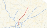
Georgia State Route 400
Encyclopedia
Georgia State Route 400 (Georgia 400, SR 400) is a highway in the U.S. state of Georgia
, concurrent with U.S. Route 19
(US 19) from exit 4B until its terminus just south of Dahlonega. ST 400 goes from Atlanta, at Interstate 85
(I-85), to Buckhead
, Sandy Springs, Roswell
, Alpharetta
, Cumming
, Dawson County
, and Dahlonega. Like the Interstate Highways, it is a limited-access road
(with exit ramps instead of intersections
), but unlike the interstates (which were renumbered by the GDOT in 2000), the exit numbers do not indicate mileage: they still go up sequential
ly one-by-one. Once ST 400 passes exit 17 (SR 306), it changes from a limited-access expressway
into an at-grade divided highway
with traffic light
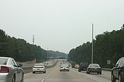
s, but still with a high speed limit
of 65 miles per hour (105 km/h) and ends at the J.B. Jones Intersection at SR 60 in Lumpkin County.
Between I-85 and I-285
, SR 400 is designated "T. Harvey Mathis Parkway"; upon reaching the Perimeter (I-285) and beyond, the highway is designated "Turner McDonald Parkway". SR 400 is known locally as the "Georgia Autobahn", the "North Georgia Autobahn", or the "Alpharetta Autobahn" due to the prevalence of speeding.
and SR 400 continues as a surface road until reaching its end at US 19
/SR 60
/SR 115
.
that Georgia 400 brought to northern Fulton and southern Forsyth counties.
In December 2005, the Georgia Department of Transportation
began widening the section from Holcomb Bridge Road to Windward Parkway from three to four lanes in the northbound direction and from two to four lanes from Windward Parkway to McFarland Parkway. Southbound, the highway is being widened to four lanes between McFarland Parkway and Holcomb Bridge Road. In addition, metal noise barrier
wall
s and a concrete divider
in the median were also added.
, a half-diamond interchange is being added on the north side of Hammond Drive, allowing southbound exits and northbound entrances.
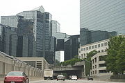
 The southern section of Georgia 400 (from I-285 to I-85) was the last section to be constructed. It was the only active toll road
in Georgia, after the Torras Causeway toll between Brunswick
and St. Simons Island on the southeastern Georgia coast was removed in 2003, until the high occupancy toll Express Lanes opened on I-85 in 2011. The GA 400 toll was to expire in 2011 after 20 years. However, Sonny Perdue
and members of the state's road and tollway authority voted on September 24, 2010 to keep the tolls on 400 until 2020. The 10-year extension will fund 11 new projects on the highway. http://www.wsbtv.com/news/25141946/detail.html
in southeast DeKalb
county; however, residents in Intown Atlanta
neighborhoods did not want the highway to cut through their neighborhoods, and a freeway revolt ensued, ending when Jimmy Carter
had the plan terminated while he was governor of Georgia. This freeway was to be known as Interstate 475
(a number now used for the Macon
bypass), a parallel route to the Downtown Connector
which is just a few miles or kilometers further west through downtown
and midtown
. The point where this road would have had its interchange with the also-doomed Interstate 485
(now Freedom Parkway and Georgia 10 to Stone Mountain Expressway) is now the site of the Jimmy Carter Presidential Library. A later routing of I-485 would have had that number running from the Downtown Connector (I-75/85), west to the current library, then up what is now 400.
Nonetheless, the northern portion of the inside-the-Perimeter route remained alive, and after lawsuit
s by residents that spent numerous years in court
, GDOT was able to force the extension through Buckhead. Dozens of homes were taken through eminent domain
or the threat of it, and the highway was built right though the middle of formerly-secluded and forest
ed neighborhoods. Many remaining residents now live on dead end
streets with significant noise pollution
or unsightly metal barrier walls.
The road opened to traffic on August 1, 1993, after three years of construction. Existing exits were renumbered up by four to accommodate the extension, which has a single toll plaza in the middle of its length. Contrary to public belief, the bonds that funded the construction of Georgia 400 south of I-285 will not be paid off until 2011. There is also currently no direct access from Georgia 400 southbound to I-85 northbound or vice versa, except by an indirect route via Sidney Marcus
Boulevard. In addition, the North Line for Atlanta's MARTA
system was constructed in the median from the Glenridge Connector to south of Lenox Road, and was opened on June 8, 1996.
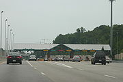
The Georgia 400 toll plaza, operated by the State Road and Tollway Authority
(SRTA), collects 50-cent tolls in both the northbound and southbound directions. Each direction has two open-road toll lanes, which collect tolls at highway speeds using the Georgia Peach Pass electronic tag
(formerly "Cruise Card"), and seven gated toll lanes which accept cash. The toll facility handles a total of approximately 120,000 vehicles per day. About 37% of transactions are paid via Peach Pass. The same technology is also used by SunPass
in Florida, TxTag
in Texas, and PikePass in Oklahoma
; however, none of these has an agreement to accept the tags of the others.
In March 2009, local TV news reports brought up an issue regarding tolls on the road, since SRTA reported that enough money has been collected to pay the bond
s used to construct the road (though prepayment prior to 2011 is prohibited). However, despite promises that the toll would be removed once the road was paid for, the tolls continue to be collected. The road costs two million dollars per year just to maintain (plus occasional repaving), and it would cost several million more for the demolition
of the toll plaza. One solution would be to simply close the toll plaza, allowing drivers to pass through without paying. If this were to occur, the state would have to raise money through other resources for new road projects, such as the reconstruction of the tollway's northern interchange at I-285, expected to cost two billion dollars.
A revival of the connection to I-675 was proposed in 2009. A tunnel
would go under East Atlanta
and other neighborhoods of Atlanta on the DeKalb side, south to I-20
. A surface road would then go south to 675. The project would be a public/private initiative.
!County
!Location
!Mile
!Exit
!Destinations
!Notes
|-
|rowspan=16|Fulton
|rowspan=4|Atlanta
|bgcolor="#ffdddd"|0.0
|bgcolor="#ffdddd"|
|bgcolor="#ffdddd"| – Downtown Atlanta
, Atlanta Airport
|bgcolor="#ffdddd"|Southern terminus; southbound exit and northbound entrance
|- bgcolor="#ffdddd"
|0.6
|1
|Sidney Marcus Boulevard – To north
|Southbound exit and northbound entrance
|-
|2.8
|2
|
|Single-point urban interchange
|-
|
|colspan=3 align=center|Toll plaza
|-
|rowspan=7|Sandy Springs
|6.6
|3
|Glenridge Perimeter Connector
|Formerly SR 407 Loop; northbound use Exit 4A (unnumbered exit from 4A's collector-distributor lanes)
|-
|6.8
|4A
| – Greenville
, Augusta
|Southbound entrance ramp is a left merge
|-bgcolor="#ddffdd"
|6.9
|4B
| – Marietta
, Chattanooga
, Birmingham
|US 19 joins northbound and leaves southbound; northbound entrance ramp is a left merge
|- bgcolor="#ffdddd"
|7.4
|4C
|Hammond Drive – Dunwoody
, Sandy Springs
|southbound exit and northbound entrance only
|-
|8.4
|5
|Abernathy Road – Dunwoody, Sandy Springs
|Northbound exit split into 5A (Dunwoody, east) and 5B (Sandy Springs, west)
|- bgcolor="#ffdddd"
|10.0
|5C
|North Springs
MARTA
station
|Southbound exit and northbound entrance only
|-
|12.0
|6
|Northridge Road
|
|-
|Roswell
|15.0
|7
|
|Peachtree Corners
; Northbound exit split into 7A (Norcross) and 7B (Roswell)
|-
|rowspan=4|Alpharetta
|16.4
|8
|Mansell Road
|North Point Mall
|-
|18.3
|9
|Haynes Bridge Road
|North Point Mall
|-
|19.6
|10
|
|
|-
|21.0
|11
|Windward Parkway
|
|-
|rowspan=7|Forsyth
|
|23.8
|12
|McFarland Parkway
|Northbound exit split into 12A (east) and 12B (west)
|-
|
|28.0
|13
|
|Johns Creek
, Peachtree Corners
|-
|
|30.8
|14
|
|Lake Lanier Islands
; northbound exit split into separate east- and westbound exit ramps
|-
|Cumming
|32.8
|15
|Bald Ridge Marina Road
|Bald Ridge Marina, Cumming Fairgrounds
|-
|
|34.7
|16
|Pilgrim Mill Road
|Lake Sidney Lanier
|-
|
|36.3
|17
|
|
|-
|
|
|colspan=3 align=center|Freeway ends
|-
|rowspan=2|Dawson
|Dawsonville
|
|
|
|
|-
|
|
|
|
|
|-
|Lumpkin
|
|bgcolor="#ddffdd"|53.7
|bgcolor="#ddffdd"|
|bgcolor="#ddffdd"|
|bgcolor="#ddffdd"|Northern terminus of 400 just after Chestatee River
bridges, U.S. 19 continues northbound via SR 60 to the NW, street continues straight NE as Long Branch Road to SR 52
|-
Georgia (U.S. state)
Georgia is a state located in the southeastern United States. It was established in 1732, the last of the original Thirteen Colonies. The state is named after King George II of Great Britain. Georgia was the fourth state to ratify the United States Constitution, on January 2, 1788...
, concurrent with U.S. Route 19
U.S. Route 19
U.S. Route 19 is a north–south U.S. Highway. Despite encroaching Interstate Highways, the route has remained a long-haul route, connecting the Gulf of Mexico with Lake Erie....
(US 19) from exit 4B until its terminus just south of Dahlonega. ST 400 goes from Atlanta, at Interstate 85
Interstate 85 in Georgia
In the U.S. state of Georgia, the major Interstate Highway, Interstate 85, runs northeast-southwest from the Alabama border near West Point, and Lanett, Ala., running through Metropolitan Atlanta, and traveling to the border with South Carolina, where it crosses the Savannah River near Lake Hartwell...
(I-85), to Buckhead
Buckhead (Atlanta)
Buckhead is the uptown district of Atlanta, Georgia, United States, comprising approximately the northern one-fifth of the city. Buckhead is a major commercial and financial center of the Southeast, and it is the third-largest business district in Atlanta, behind Downtown and Midtown...
, Sandy Springs, Roswell
Roswell, Georgia
Roswell is a city located in northern Fulton County; it is a suburb of northern Atlanta, Georgia, United States. The 2010 Census population was 88,346. It is the eighth largest city in Georgia...
, Alpharetta
Alpharetta, Georgia
-Demographics:As of the census of 2000, there were 34,854 people, 13,911 households, and 8,916 families residing in the city. The population density was 1,631.6 people per square mile . There were 14,670 housing units at an average density of 686.7 per square mile...
, Cumming
Cumming, Georgia
Cumming is a city in Forsyth County, Georgia, United States. The population was 5,430 at the 2010 census. However, places with a Cumming mailing address have a population of around 100,000...
, Dawson County
Dawson County, Georgia
Dawson County is a county located in the U.S. state of Georgia. It was created on December 3, 1857 from Gilmer and Lumpkin counties. As of 2000, the population is 15,999. The 2007 Census Estimate showed a population of 21,484...
, and Dahlonega. Like the Interstate Highways, it is a limited-access road
Limited-access road
A limited-access road known by various terms worldwide, including limited-access highway, dual-carriageway and expressway, is a highway or arterial road for high-speed traffic which has many or most characteristics of a controlled-access highway , including limited or no access to adjacent...
(with exit ramps instead of intersections
Intersection (road)
An intersection is a road junction where two or more roads either meet or cross at grade . An intersection may be 3-way - a T junction or fork, 4-way - a crossroads, or 5-way or more...
), but unlike the interstates (which were renumbered by the GDOT in 2000), the exit numbers do not indicate mileage: they still go up sequential
Sequence
In mathematics, a sequence is an ordered list of objects . Like a set, it contains members , and the number of terms is called the length of the sequence. Unlike a set, order matters, and exactly the same elements can appear multiple times at different positions in the sequence...
ly one-by-one. Once ST 400 passes exit 17 (SR 306), it changes from a limited-access expressway
Limited-access road
A limited-access road known by various terms worldwide, including limited-access highway, dual-carriageway and expressway, is a highway or arterial road for high-speed traffic which has many or most characteristics of a controlled-access highway , including limited or no access to adjacent...
into an at-grade divided highway
Divided Highway
Divided Highway is a compilation album by American rock band The Doobie Brothers, released in 2003. . All tracks are taken from the albums Cycles and Brotherhood .-Track listing:...
with traffic light
Traffic light
Traffic lights, which may also be known as stoplights, traffic lamps, traffic signals, signal lights, robots or semaphore, are signalling devices positioned at road intersections, pedestrian crossings and other locations to control competing flows of traffic...
s, but still with a high speed limit
Speed limit
Road speed limits are used in most countries to regulate the speed of road vehicles. Speed limits may define maximum , minimum or no speed limit and are normally indicated using a traffic sign...
of 65 miles per hour (105 km/h) and ends at the J.B. Jones Intersection at SR 60 in Lumpkin County.
Between I-85 and I-285
Interstate 285
Interstate 285 is an Interstate Highway loop encircling Atlanta, Georgia, for . I-285 is also known as unsigned State Route 407 and is colloquially referred to as the Perimeter. Suburban sprawl has made it one of the most heavily traveled roadways in the United States, and portions of the highway...
, SR 400 is designated "T. Harvey Mathis Parkway"; upon reaching the Perimeter (I-285) and beyond, the highway is designated "Turner McDonald Parkway". SR 400 is known locally as the "Georgia Autobahn", the "North Georgia Autobahn", or the "Alpharetta Autobahn" due to the prevalence of speeding.
Route description
Georgia State Route 400 begins at Interstate 85 just north of Downtown Atlanta and starts as a toll road through Buckhead. At Interstate 285, the road becomes a free road, heading north into the northern Atlanta suburbs. The freeway section ends at SR 306Georgia State Route 306
State Route 306 is a west–east route located entirely in Forsyth County, Georgia. From its western terminus at SR 20 west of Cumming, the route arcs north and west around downtown Cumming to SR 9. The routes cosign north. SR 306 then departs SR 9 traveling to the east to its interchange at...
and SR 400 continues as a surface road until reaching its end at US 19
U.S. Route 19 in Georgia
U.S. Route 19 in Georgia runs through Georgia from the Florida border south of Thomasville, Georgia—through Atlanta—to the North Carolina border at a point north of Nottely Lake, Georgia.-Route:...
/SR 60
Georgia State Route 60
State Route 60 begins at S.R. 124 in Hoschton and travels north through Gainesville and across I-985. The route overlaps U.S. 19 in Lumpkin County in Dahlonega. The route ends after traveling through McCaysville at the Tennessee state line....
/SR 115
Georgia State Route 115
State Route 115 is a state highway in the northeastern part of the U.S. state of Georgia. Its western terminus is at U.S. Route 19 and State Route 60 south of Dahlonega. The eastern terminus is at State Route 13 east of Clarkesville. It traverses the counties of Habersham,...
.
Original portion (I-285 to Georgia 306)
Planning for Georgia 400 began in 1954. The initial section north of I-285 was officially dedicated on May 24, 1971 and subsequent additions to the north opened in stages through 1981. The road was subsequently widened in 1989 from its original four-lane configuration to eight lanes between I-285 and Holcomb Bridge Road. The widening projects were necessitated by the massive growthSuburbanization
Suburbanization a term used to describe the growth of areas on the fringes of major cities. It is one of the many causes of the increase in urban sprawl. Many residents of metropolitan regions work within the central urban area, choosing instead to live in satellite communities called suburbs...
that Georgia 400 brought to northern Fulton and southern Forsyth counties.
In December 2005, the Georgia Department of Transportation
Georgia Department of Transportation
The Georgia Department of Transportation is the organization in charge of developing and maintaining all state and federal roadways in the U.S. state of Georgia. In addition to highways, the department also has a limited role in developing public transportation and general aviation programs...
began widening the section from Holcomb Bridge Road to Windward Parkway from three to four lanes in the northbound direction and from two to four lanes from Windward Parkway to McFarland Parkway. Southbound, the highway is being widened to four lanes between McFarland Parkway and Holcomb Bridge Road. In addition, metal noise barrier
Noise barrier
A noise barrier is an exterior structure designed to protect sensitive land uses from noise pollution...
wall
Wall
A wall is a usually solid structure that defines and sometimes protects an area. Most commonly, a wall delineates a building and supports its superstructure, separates space in buildings into rooms, or protects or delineates a space in the open air...
s and a concrete divider
Jersey barrier
A Jersey barrier or Jersey wall is a modular concrete barrier employed to separate lanes of traffic. It is designed to both minimize vehicle damage in cases of incidental contact while still preventing crossover in the case of head-on accidents....
in the median were also added.
, a half-diamond interchange is being added on the north side of Hammond Drive, allowing southbound exits and northbound entrances.
Georgia 400 extension (I-85 to I-285)
Toll road
A toll road is a privately or publicly built road for which a driver pays a toll for use. Structures for which tolls are charged include toll bridges and toll tunnels. Non-toll roads are financed using other sources of revenue, most typically fuel tax or general tax funds...
in Georgia, after the Torras Causeway toll between Brunswick
Brunswick, Georgia
Brunswick is the major urban and economic center in southeastern Georgia in the United States. The municipality is located on a harbor near the Atlantic Ocean, approximately 30 miles north of Florida and 70 miles south of South Carolina. Brunswick is bordered on the east by the Atlantic...
and St. Simons Island on the southeastern Georgia coast was removed in 2003, until the high occupancy toll Express Lanes opened on I-85 in 2011. The GA 400 toll was to expire in 2011 after 20 years. However, Sonny Perdue
Sonny Perdue
George Ervin "Sonny" Perdue III, was the 81st Governor of Georgia. Upon his inauguration in January 2003, he became the first Republican governor of Georgia since Benjamin F. Conley served during Reconstruction in the 1870s....
and members of the state's road and tollway authority voted on September 24, 2010 to keep the tolls on 400 until 2020. The 10-year extension will fund 11 new projects on the highway. http://www.wsbtv.com/news/25141946/detail.html
Freeway revolt
At one time, Georgia 400 was to connect to Interstate 675Interstate 675 (Georgia)
Interstate 675 was built in southeast metro Atlanta during the mid-1980s to alleviate Interstate 75 to the west, for traffic bound to Interstate 285 east. It is 11.04 miles in length, running from I-75 in the south from the city of Stockbridge to I-285 at its north end...
in southeast DeKalb
DeKalb County, Georgia
DeKalb County is a county located in the U.S. state of Georgia. The population of the county was 691,893 at the 2010 census. Its county seat is the city of Decatur. It is bordered to the west by Fulton County and contains roughly 10% of the city of Atlanta...
county; however, residents in Intown Atlanta
Intown Atlanta
Intown Atlanta is a term very frequently used in metro Atlanta to designate an area containing parts of the City of Atlanta and bordering communities...
neighborhoods did not want the highway to cut through their neighborhoods, and a freeway revolt ensued, ending when Jimmy Carter
Jimmy Carter
James Earl "Jimmy" Carter, Jr. is an American politician who served as the 39th President of the United States and was the recipient of the 2002 Nobel Peace Prize, the only U.S. President to have received the Prize after leaving office...
had the plan terminated while he was governor of Georgia. This freeway was to be known as Interstate 475
Interstate 475 (Georgia)
Interstate 475 is a long Interstate highway in Georgia, splitting off from Interstate 75 and bypassing Macon, Georgia. It is also unsigned State Route 408...
(a number now used for the Macon
Macon, Georgia
Macon is a city located in central Georgia, US. Founded at the fall line of the Ocmulgee River, it is part of the Macon metropolitan area, and the county seat of Bibb County. A small portion of the city extends into Jones County. Macon is the biggest city in central Georgia...
bypass), a parallel route to the Downtown Connector
Downtown Connector
In Atlanta, Georgia, the Downtown Connector or 75/85 is the concurrent section of Interstate 75 and Interstate 85 through the core of the city. Beginning at the I-85/Langford Parkway interchange, the Downtown Connector runs generally due north, meeting the east-west Interstate 20 in the middle....
which is just a few miles or kilometers further west through downtown
Downtown Atlanta
Downtown Atlanta is the first and largest of the three financial districts in the city of Atlanta. Downtown Atlanta is the location of many corporate or regional headquarters, city, county, state and federal government facilities, sporting facilities, and is the central tourist attraction of the city...
and midtown
Midtown Atlanta
Midtown is the second largest financial district in the city of Atlanta, Georgia, situated between the commercial and financial districts of Downtown and SoNo to the south and the affluent residential and commercial district of Buckhead to the north...
. The point where this road would have had its interchange with the also-doomed Interstate 485
Interstate 485 (Georgia)
Interstate 485 was a proposed U.S. Interstate Highway in Atlanta, Georgia, heading eastwards and then northwards from downtown. The 5.9 mile-long route would have begun at the Downtown Connector and used the proposed State Route 410 east to the junction with the also-proposed State Route 400...
(now Freedom Parkway and Georgia 10 to Stone Mountain Expressway) is now the site of the Jimmy Carter Presidential Library. A later routing of I-485 would have had that number running from the Downtown Connector (I-75/85), west to the current library, then up what is now 400.
Nonetheless, the northern portion of the inside-the-Perimeter route remained alive, and after lawsuit
Lawsuit
A lawsuit or "suit in law" is a civil action brought in a court of law in which a plaintiff, a party who claims to have incurred loss as a result of a defendant's actions, demands a legal or equitable remedy. The defendant is required to respond to the plaintiff's complaint...
s by residents that spent numerous years in court
Court
A court is a form of tribunal, often a governmental institution, with the authority to adjudicate legal disputes between parties and carry out the administration of justice in civil, criminal, and administrative matters in accordance with the rule of law...
, GDOT was able to force the extension through Buckhead. Dozens of homes were taken through eminent domain
Eminent domain
Eminent domain , compulsory purchase , resumption/compulsory acquisition , or expropriation is an action of the state to seize a citizen's private property, expropriate property, or seize a citizen's rights in property with due monetary compensation, but without the owner's consent...
or the threat of it, and the highway was built right though the middle of formerly-secluded and forest
Forest
A forest, also referred to as a wood or the woods, is an area with a high density of trees. As with cities, depending where you are in the world, what is considered a forest may vary significantly in size and have various classification according to how and what of the forest is composed...
ed neighborhoods. Many remaining residents now live on dead end
Cul-de-sac
A cul-de-sac is a word of French origin referring to a dead end, close, no through road or court meaning dead-end street with only one inlet/outlet...
streets with significant noise pollution
Noise pollution
Noise pollution is excessive, displeasing human, animal or machine-created environmental noise that disrupts the activity or balance of human or animal life...
or unsightly metal barrier walls.
The road opened to traffic on August 1, 1993, after three years of construction. Existing exits were renumbered up by four to accommodate the extension, which has a single toll plaza in the middle of its length. Contrary to public belief, the bonds that funded the construction of Georgia 400 south of I-285 will not be paid off until 2011. There is also currently no direct access from Georgia 400 southbound to I-85 northbound or vice versa, except by an indirect route via Sidney Marcus
Sidney Marcus
Sidney J. Marcus was a Georgia legislator from Atlanta's 26th district, now the 106th district, who served in the Georgia General Assembly from 1968 until his death in 1983. He served on several committees: Health and Ecology, on which he was chairman; Ways and Means; and Rules. For several...
Boulevard. In addition, the North Line for Atlanta's MARTA
Metropolitan Atlanta Rapid Transit Authority
The Metropolitan Atlanta Rapid Transit Authority or MARTA is the principal rapid-transit system in the Atlanta metropolitan area and the ninth-largest in the United States. Formed in 1971 as strictly a bus system, MARTA operates a network of bus routes linked to a rapid transit system consisting...
system was constructed in the median from the Glenridge Connector to south of Lenox Road, and was opened on June 8, 1996.
The Georgia 400 toll plaza, operated by the State Road and Tollway Authority
State Road and Tollway Authority
The State Road and Tollway Authority is a government agency of the U.S. state of Georgia. It is responsible for financing transportation initiatives and operating the state's only current toll road, the Georgia 400 extension. SRTA collects tolls on the southern portion of the expressway, at a...
(SRTA), collects 50-cent tolls in both the northbound and southbound directions. Each direction has two open-road toll lanes, which collect tolls at highway speeds using the Georgia Peach Pass electronic tag
Electronic toll collection
Electronic toll collection , an adaptation of military "identification friend or foe" technology, aims to eliminate the delay on toll roads by collecting tolls electronically. It is thus a technological implementation of a road pricing concept...
(formerly "Cruise Card"), and seven gated toll lanes which accept cash. The toll facility handles a total of approximately 120,000 vehicles per day. About 37% of transactions are paid via Peach Pass. The same technology is also used by SunPass
SunPass
SunPass is an electronic toll collection system in use by the State of Florida and was originally created by the Florida Department of Transportation's Florida's Turnpike...
in Florida, TxTag
TxTAG
TxTag , operated by the Texas Department of Transportation , is one of three interoperable electronic toll collection systems in Texas.-Current system status:The TxTag brand name is used on the following highways:* Operated by TxDOT:...
in Texas, and PikePass in Oklahoma
Oklahoma
Oklahoma is a state located in the South Central region of the United States of America. With an estimated 3,751,351 residents as of the 2010 census and a land area of 68,667 square miles , Oklahoma is the 28th most populous and 20th-largest state...
; however, none of these has an agreement to accept the tags of the others.
In March 2009, local TV news reports brought up an issue regarding tolls on the road, since SRTA reported that enough money has been collected to pay the bond
Municipal bond
A municipal bond is a bond issued by a city or other local government, or their agencies. Potential issuers of municipal bonds includes cities, counties, redevelopment agencies, special-purpose districts, school districts, public utility districts, publicly owned airports and seaports, and any...
s used to construct the road (though prepayment prior to 2011 is prohibited). However, despite promises that the toll would be removed once the road was paid for, the tolls continue to be collected. The road costs two million dollars per year just to maintain (plus occasional repaving), and it would cost several million more for the demolition
Demolition
Demolition is the tearing-down of buildings and other structures, the opposite of construction. Demolition contrasts with deconstruction, which involves taking a building apart while carefully preserving valuable elements for re-use....
of the toll plaza. One solution would be to simply close the toll plaza, allowing drivers to pass through without paying. If this were to occur, the state would have to raise money through other resources for new road projects, such as the reconstruction of the tollway's northern interchange at I-285, expected to cost two billion dollars.
A revival of the connection to I-675 was proposed in 2009. A tunnel
Tunnel
A tunnel is an underground passageway, completely enclosed except for openings for egress, commonly at each end.A tunnel may be for foot or vehicular road traffic, for rail traffic, or for a canal. Some tunnels are aqueducts to supply water for consumption or for hydroelectric stations or are sewers...
would go under East Atlanta
East Atlanta
East Atlanta is a neighborhood of Atlanta, Georgia in the eastern portion of the city. The term "East Atlanta" is frequently misused to refer to the entire eastern portion of the city located in DeKalb County, roughly 10% of Atlanta's area annexed in 1909...
and other neighborhoods of Atlanta on the DeKalb side, south to I-20
Interstate 20 in Georgia
In Georgia, Interstate 20 runs from the Alabama border to the Savannah River, which the Georgia-South Carolina border straddles. It passes through the heavily congested Atlanta metropolitan area and exits the state at Augusta...
. A surface road would then go south to 675. The project would be a public/private initiative.
Tolls
The toll plaza is located north of Lenox Road (Exit 2). Tolls are collected in both directions. The toll is 50 cents for a 2-axle vehicle, $1.50 for 3 axles, plus 50 cents for each additional axle. Tolls are not collected on ramps.Major intersections
{| class=wikitable!County
!Location
!Mile
!Exit
!Destinations
!Notes
|-
|rowspan=16|Fulton
Fulton County, Georgia
Fulton County is a county located in the U.S. state of Georgia. Its county seat is Atlanta, the state capital since 1868 and the principal county of the Atlanta metropolitan area...
|rowspan=4|Atlanta
Atlanta, Georgia
Atlanta is the capital and most populous city in the U.S. state of Georgia. According to the 2010 census, Atlanta's population is 420,003. Atlanta is the cultural and economic center of the Atlanta metropolitan area, which is home to 5,268,860 people and is the ninth largest metropolitan area in...
|bgcolor="#ffdddd"|0.0
|bgcolor="#ffdddd"|
|bgcolor="#ffdddd"| – Downtown Atlanta
Downtown Atlanta
Downtown Atlanta is the first and largest of the three financial districts in the city of Atlanta. Downtown Atlanta is the location of many corporate or regional headquarters, city, county, state and federal government facilities, sporting facilities, and is the central tourist attraction of the city...
, Atlanta Airport
Hartsfield-Jackson Atlanta International Airport
Hartsfield–Jackson Atlanta International Airport , known locally as Atlanta Airport, Hartsfield Airport, and Hartsfield–Jackson, is located seven miles south of the central business district of Atlanta, Georgia, United States...
|bgcolor="#ffdddd"|Southern terminus; southbound exit and northbound entrance
|- bgcolor="#ffdddd"
|0.6
|1
|Sidney Marcus Boulevard – To north
|Southbound exit and northbound entrance
|-
|2.8
|2
|
|Single-point urban interchange
Single-point urban interchange
A single-point urban interchange , also called a single-point interchange or single-point diamond interchange , is a type of highway interchange...
|-
|
|colspan=3 align=center|Toll plaza
|-
|rowspan=7|Sandy Springs
Sandy Springs, Georgia
Sandy Springs is a city in north Georgia, United States. It is a northern suburb of Atlanta. With a 2010 population of 93,853, Sandy Springs is the sixth-largest city in the state and the second-largest city in Metro Atlanta. Sandy Springs is located in north Fulton County, Georgia, just south of...
|6.6
|3
|Glenridge Perimeter Connector
|Formerly SR 407 Loop; northbound use Exit 4A (unnumbered exit from 4A's collector-distributor lanes)
|-
|6.8
|4A
| – Greenville
Greenville, South Carolina
-Law and government:The city of Greenville adopted the Council-Manager form of municipal government in 1976.-History:The area was part of the Cherokee Nation's protected grounds after the Treaty of 1763, which ended the French and Indian War. No White man was allowed to enter, though some families...
, Augusta
Augusta, Georgia
Augusta is a consolidated city in the U.S. state of Georgia, located along the Savannah River. As of the 2010 census, the Augusta–Richmond County population was 195,844 not counting the unconsolidated cities of Hephzibah and Blythe.Augusta is the principal city of the Augusta-Richmond County...
|Southbound entrance ramp is a left merge
|-bgcolor="#ddffdd"
|6.9
|4B
| – Marietta
Marietta, Georgia
Marietta is a city located in central Cobb County, Georgia, United States, and is its county seat.As of the 2010 census, the city had a total population of 56,579, making it one of metro Atlanta's largest suburbs...
, Chattanooga
Chattanooga, Tennessee
Chattanooga is the fourth-largest city in the US state of Tennessee , with a population of 169,887. It is the seat of Hamilton County...
, Birmingham
Birmingham, Alabama
Birmingham is the largest city in Alabama. The city is the county seat of Jefferson County. According to the 2010 United States Census, Birmingham had a population of 212,237. The Birmingham-Hoover Metropolitan Area, in estimate by the U.S...
|US 19 joins northbound and leaves southbound; northbound entrance ramp is a left merge
|- bgcolor="#ffdddd"
|7.4
|4C
|Hammond Drive – Dunwoody
Dunwoody, Georgia
Dunwoody is a city located in DeKalb County, Georgia, United States. It is a northern suburb of Atlanta. Dunwoody became incorporated as a city on December 1, 2008...
, Sandy Springs
|southbound exit and northbound entrance only
|-
|8.4
|5
|Abernathy Road – Dunwoody, Sandy Springs
|Northbound exit split into 5A (Dunwoody, east) and 5B (Sandy Springs, west)
|- bgcolor="#ffdddd"
|10.0
|5C
|North Springs
North Springs (MARTA station)
North Springs is an elevated metro station in the Metropolitan Atlanta Rapid Transit Authority rail system and the northern terminus for the Red Line...
MARTA
Metropolitan Atlanta Rapid Transit Authority
The Metropolitan Atlanta Rapid Transit Authority or MARTA is the principal rapid-transit system in the Atlanta metropolitan area and the ninth-largest in the United States. Formed in 1971 as strictly a bus system, MARTA operates a network of bus routes linked to a rapid transit system consisting...
station
|Southbound exit and northbound entrance only
|-
|12.0
|6
|Northridge Road
|
|-
|Roswell
Roswell, Georgia
Roswell is a city located in northern Fulton County; it is a suburb of northern Atlanta, Georgia, United States. The 2010 Census population was 88,346. It is the eighth largest city in Georgia...
|15.0
|7
|
|Peachtree Corners
Peachtree Corners, Georgia
Peachtree Corners is a city in western Gwinnett County, Georgia, United States. It is a northern suburb of Atlanta, located east of Dunwoody and south of Johns Creek. Out of all of Atlanta's northern suburbs, Peachtree Corners is the only one that was developed as a planned community...
; Northbound exit split into 7A (Norcross) and 7B (Roswell)
|-
|rowspan=4|Alpharetta
Alpharetta, Georgia
-Demographics:As of the census of 2000, there were 34,854 people, 13,911 households, and 8,916 families residing in the city. The population density was 1,631.6 people per square mile . There were 14,670 housing units at an average density of 686.7 per square mile...
|16.4
|8
|Mansell Road
|North Point Mall
North Point Mall
North Point Mall, is a super-regional shopping mall, located in Alpharetta, Georgia .The mall opened on October 3, 1993 as one of the largest shopping malls in the country. The mall, originally a Homart property, is now owned and managed by General Growth Properties...
|-
|18.3
|9
|Haynes Bridge Road
|North Point Mall
|-
|19.6
|10
|
|
|-
|21.0
|11
|Windward Parkway
|
|-
|rowspan=7|Forsyth
Forsyth County, Georgia
Forsyth County is a county located in the U.S. state of Georgia. The county seat is Cumming, Georgia. Forsyth County is a part of the Atlanta metropolitan area...
|
|23.8
|12
|McFarland Parkway
|Northbound exit split into 12A (east) and 12B (west)
|-
|
|28.0
|13
|
|Johns Creek
Johns Creek, Georgia
Johns Creek is a suburban city in Fulton County, Georgia, USA, which incorporated December 1, 2006. It is named for a tributary that runs through the area. The city was created out of the northeastern part of unincorporated Fulton County...
, Peachtree Corners
Peachtree Corners, Georgia
Peachtree Corners is a city in western Gwinnett County, Georgia, United States. It is a northern suburb of Atlanta, located east of Dunwoody and south of Johns Creek. Out of all of Atlanta's northern suburbs, Peachtree Corners is the only one that was developed as a planned community...
|-
|
|30.8
|14
|
|Lake Lanier Islands
Lake Lanier Islands
Lake Lanier Islands are a small group of islands located on Lake Lanier, the largest lake in Georgia, located north of Atlanta, Georgia, USA. The islands were previously large hills that became the largest land chain remaining after the flooding of the Chattahoochee river valley located near...
; northbound exit split into separate east- and westbound exit ramps
|-
|Cumming
Cumming, Georgia
Cumming is a city in Forsyth County, Georgia, United States. The population was 5,430 at the 2010 census. However, places with a Cumming mailing address have a population of around 100,000...
|32.8
|15
|Bald Ridge Marina Road
|Bald Ridge Marina, Cumming Fairgrounds
|-
|
|34.7
|16
|Pilgrim Mill Road
|Lake Sidney Lanier
|-
|
|36.3
|17
|
|
|-
|
|
|colspan=3 align=center|Freeway ends
|-
|rowspan=2|Dawson
Dawson County, Georgia
Dawson County is a county located in the U.S. state of Georgia. It was created on December 3, 1857 from Gilmer and Lumpkin counties. As of 2000, the population is 15,999. The 2007 Census Estimate showed a population of 21,484...
|Dawsonville
Dawsonville, Georgia
Dawsonville is a city in Dawson County, Georgia, United States. The population was 619 at the 2000 census. The city is the county seat of Dawson County...
|
|
|
|
|-
|
|
|
|
|
|-
|Lumpkin
Lumpkin County, Georgia
Lumpkin County is a county located in the U.S. state of Georgia. As of the 2010 census, the population was 29,966. Its county seat is Dahlonega.- History :...
|
|bgcolor="#ddffdd"|53.7
|bgcolor="#ddffdd"|
|bgcolor="#ddffdd"|
|bgcolor="#ddffdd"|Northern terminus of 400 just after Chestatee River
Chestatee River
The Chestatee River is a river in the Appalachian Mountains of northern Georgia, USA. It begins at the confluence of Dicks Creek and Frogtown Creek The Chestatee River (variant spellings Chestatie, Chestetee, Chostatee, Chosteta, none in modern use) is a river in the Appalachian Mountains of...
bridges, U.S. 19 continues northbound via SR 60 to the NW, street continues straight NE as Long Branch Road to SR 52
Georgia State Route 52
State Route 52 is a west–east state route located in the northern part of the U.S. state of Georgia. The route travels from Interstate 75 in Dalton to State Route 98 in Maysville.-Route description:...
|-