
Georgia State Route 52
Encyclopedia
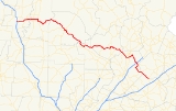
State Route 52 is a west–east state route located in the northern part of the U.S. state
of Georgia
. The route travels from Interstate 75
in Dalton
to State Route 98 in Maysville
.
with U.S. Route 76 Business. The two routes travel east to the junction of U.S. Route 76
, where U.S. Route 76 business ends, and State Route 52 continues east, cosigned with U.S. Route 76. North of Chatsworth
, the two routes become cosigned with U.S. Route 411
/State Route 2/State Route 61, and all five travel south into downtown Chatsworth, where State Route 52 and State Route 2 depart and continue east. The routes travel over Fort Mountain
before descending and continuing southeast into Ellijay
. In Ellijay, State Route 52 departs State Route 2, and continues southeast, running through rural portions of Gilmer
and northern Dawson County
. West of Amicalola Falls State Park
, the route assumes an easterly routing at the junction with State Route 183. West of Dahlonega
, State Route 52 becomes cosigned with State Route 9, and the two routes continue east to Dahlonega, bypassing downtown to the south and east. Shortly after becoming cosigned with U.S. Route 19
and State Route 60, State Route 52 departs and continues east. After a brief cosignage with State Route 115, State Route 52 assumes a southeasterly routing. After bypassing the town of Clermont
, the route continues southeast through Lula
and Gillsville
to its eastern terminus in Maysville at State Route 98.
State Route 52 is a significant corridor in north Georgia. Most of the route west of Dahlonega sees an Average Annual Daily Traffic of more than 2,000 vehicles. Since the route serves as the most direct connection with Interstate 75 to downtown Dalton, the portion of the route in and around Dalton sees an AADT of over 20,000 vehicles.
-Murray
county line southeast to State Route 225, then east into downtown Chatsworth, where it ends at the State Route 52 mainline. The route also passes by the Chief Vann House Historic Site
.
State Route 52 Business serves downtown Dahlonega. It connects to the State Route 52 mainline on the south and east of the city.
State Route 52 Connector connects State Route 71 north of Dalton with the State Route 52 mainline east of Dalton. State Route 52 Connector runs along the northeast quadrant of the Dalton Bypass, and is cosigned with U.S. Route 76 for its entire length.
U.S. state
A U.S. state is any one of the 50 federated states of the United States of America that share sovereignty with the federal government. Because of this shared sovereignty, an American is a citizen both of the federal entity and of his or her state of domicile. Four states use the official title of...
of Georgia
Georgia (U.S. state)
Georgia is a state located in the southeastern United States. It was established in 1732, the last of the original Thirteen Colonies. The state is named after King George II of Great Britain. Georgia was the fourth state to ratify the United States Constitution, on January 2, 1788...
. The route travels from Interstate 75
Interstate 75
Interstate 75 is a major north–south Interstate Highway in the Great Lakes and Southeastern regions of the United States. It travels from State Road 826 and State Road 924 in Hialeah, Florida to Sault Ste. Marie, Michigan, at the Ontario, Canada, border...
in Dalton
Dalton, Georgia
Dalton is a city in Whitfield County, Georgia, United States. It is the county seat of Whitfield County and the principal city of the Dalton, Georgia Metropolitan Statistical Area, which encompasses all of both Murray and Whitfield counties. As of the 2010 census, the city had a population of 33,128...
to State Route 98 in Maysville
Maysville, Georgia
Maysville is a town in Banks and Jackson Counties in the U.S. state of Georgia. The population was 1,663 at the 2000 census.-Geography:Maysville is located at ....
.
Route description
From its western terminus at exit 333 on I-75 in Dalton, State Route 52 runs due east along Walnut Avenue into downtown Dalton, where it becomes cosignedConcurrency (road)
A concurrency, overlap, or coincidence in a road network is an instance of one physical road bearing two or more different highway, motorway, or other route numbers...
with U.S. Route 76 Business. The two routes travel east to the junction of U.S. Route 76
U.S. Route 76
U.S. Route 76 is an east–west United States highway that runs for from Chattanooga, Tennessee to Wrightsville Beach, North Carolina.-Tennessee:...
, where U.S. Route 76 business ends, and State Route 52 continues east, cosigned with U.S. Route 76. North of Chatsworth
Chatsworth, Georgia
Chatsworth is a city in Murray County, Georgia, United States. It is part of the Dalton, Georgia Metropolitan Statistical Area. The population was 3,531 at the 2000 census, but was estimated around 3,890 as of the 2005 census. The city is the county seat of Murray County...
, the two routes become cosigned with U.S. Route 411
U.S. Route 411
U.S. Highway 411 is an alternate parallel-highway associated with U.S. Highway 11. U.S. 411 extends for about 313 miles from U.S. Route 78 in Leeds, Jefferson County, Alabama, to U.S. Highway 25 in Newport, Cocke County, Tennessee. U.S. 411 passes through the northeastern State of Alabama, the...
/State Route 2/State Route 61, and all five travel south into downtown Chatsworth, where State Route 52 and State Route 2 depart and continue east. The routes travel over Fort Mountain
Fort Mountain State Park
Fort Mountain State Park is a 3,712 acre Georgia state park located between Chatsworth and Ellijay on Fort Mountain. The mountain is named for an ancient 885 foot long rock wall located on the peak. The wall is thought to have been built by area Native Americans either for defense or for...
before descending and continuing southeast into Ellijay
Ellijay, Georgia
Ellijay is a city in Gilmer County, Georgia, United States. The population was 1,584 at the 2000 census. The city is the county seat of Gilmer County.Ellijay lies where two rivers, the Ellijay and the Cartecay, come together to form the Coosawattee River...
. In Ellijay, State Route 52 departs State Route 2, and continues southeast, running through rural portions of Gilmer
Gilmer County, Georgia
Gilmer County is a county located in the U.S. state of Georgia. It was created on December 3, 1832 and was named for George Rockingham Gilmer. As of 2000, the population was 23,456. The 2007 Census Estimate shows a population of 28,389...
and northern Dawson County
Dawson County, Georgia
Dawson County is a county located in the U.S. state of Georgia. It was created on December 3, 1857 from Gilmer and Lumpkin counties. As of 2000, the population is 15,999. The 2007 Census Estimate showed a population of 21,484...
. West of Amicalola Falls State Park
Amicalola Falls State Park
Amicalola Falls State Park is an 829 acre Georgia state park located between Ellijay and Dahlonega in Dawsonville, Georgia. The park's name is derived from a Cherokee language word meaning "tumbling waters". The park is home to Amicalola Falls, a 729-foot waterfall, making it the highest in...
, the route assumes an easterly routing at the junction with State Route 183. West of Dahlonega
Dahlonega, Georgia
Dahlonega is a city in Lumpkin County, Georgia, United States, and is its county seat. As of the 2010 census, the city had a population of 5,242....
, State Route 52 becomes cosigned with State Route 9, and the two routes continue east to Dahlonega, bypassing downtown to the south and east. Shortly after becoming cosigned with U.S. Route 19
U.S. Route 19
U.S. Route 19 is a north–south U.S. Highway. Despite encroaching Interstate Highways, the route has remained a long-haul route, connecting the Gulf of Mexico with Lake Erie....
and State Route 60, State Route 52 departs and continues east. After a brief cosignage with State Route 115, State Route 52 assumes a southeasterly routing. After bypassing the town of Clermont
Clermont, Georgia
Clermont is a town in Hall County, Georgia, United States. The population was 419 at the 2000 census. It is part of the Gainesville, GA Metropolitan Statistical Area.-Geography:Clermont is located at ....
, the route continues southeast through Lula
Lula, Georgia
Lula is a city in Banks and Hall Counties in the U.S. state of Georgia. The population was 1,438 at the 2000 census. The Hall County portion of Lula is part of the Gainesville, GA Metropolitan Statistical Area. Lula is home of RailRoad Days, a yearly festival usually every May. Major roads near...
and Gillsville
Gillsville, Georgia
Gillsville is a city in Banks and Hall Counties in the U.S. state of Georgia. The population was 195 at the 2000 census.The Hall County portion of Gillsville is part of the Gainesville, GA Metropolitan Statistical Area.-Geography:...
to its eastern terminus in Maysville at State Route 98.
State Route 52 is a significant corridor in north Georgia. Most of the route west of Dahlonega sees an Average Annual Daily Traffic of more than 2,000 vehicles. Since the route serves as the most direct connection with Interstate 75 to downtown Dalton, the portion of the route in and around Dalton sees an AADT of over 20,000 vehicles.
Related Routes
State Route 52 Alternate serves as an alternate route from Dalton to Chatsworth. It runs from the State Route 52 mainline just east of the WhitfieldWhitfield County, Georgia
Whitfield County is a county located in the U.S. state of Georgia. It was created on December 30, 1851. The 2010 Census shows a population of 102,599. The county seat is Dalton.It is part of the Dalton, Georgia, Metropolitan Statistical Area.-Civil War:...
-Murray
Murray County, Georgia
Murray County is a county located in the U.S. state of Georgia. As of 2000, the population was 36,506. The 2007 Census Estimate showed a population of 40,664. The county seat is Chatsworth.It is part of the Dalton, Georgia, Metropolitan Statistical Area....
county line southeast to State Route 225, then east into downtown Chatsworth, where it ends at the State Route 52 mainline. The route also passes by the Chief Vann House Historic Site
Chief Vann House Historic Site
The Chief Vann House is the first brick residence in the Cherokee Nation that has been called the "Showplace of the Cherokee Nation". Owned by a Cherokee chief named Chief James Vann, The Vann House is a Georgia Historic Site on the National Register of Historic Places and one of the oldest...
.
State Route 52 Business serves downtown Dahlonega. It connects to the State Route 52 mainline on the south and east of the city.
State Route 52 Connector connects State Route 71 north of Dalton with the State Route 52 mainline east of Dalton. State Route 52 Connector runs along the northeast quadrant of the Dalton Bypass, and is cosigned with U.S. Route 76 for its entire length.