
Interstate 20 in Georgia
Encyclopedia
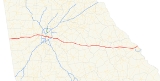
In Georgia
, Interstate 20
runs from the Alabama
border to the Savannah River
, which the Georgia-South Carolina
border straddles. It passes through the heavily congested Atlanta metropolitan area and exits the state at Augusta
. The highway allows Georgians and various cargo to travel to various locations, including Columbia, South Carolina
; Birmingham, Alabama
; Jackson, Mississippi
and Dallas, Texas
. I-20 has the unsigned state highway designation of State Route 402.
I-20 enters the Peach State near Tallapoosa
and after passing through western Georgia, it enters the Atlanta metropolitan area. On clear days, eastbound motorists get their first view of downtown Atlanta as they come over the top of the Six Flags Hill
. The Six Flags Over Georgia
amusement park is easily visible off exit 47 eastbound. In Atlanta
, the highway passes through the heart of the city, crossing Interstate 75
and Interstate 85
, which share a common expressway (the "Downtown Connector
"). It continues though Metropolitan Atlanta eastward and through the eastern half of Georgia until it exits the state, crossing the Savannah River
at Augusta
.
Several stretches of Interstate 20 are named for various people and reasons:
Georgia (U.S. state)
Georgia is a state located in the southeastern United States. It was established in 1732, the last of the original Thirteen Colonies. The state is named after King George II of Great Britain. Georgia was the fourth state to ratify the United States Constitution, on January 2, 1788...
, Interstate 20
Interstate 20
Interstate 20 is a major east–west Interstate Highway in the Southern United States. I‑20 runs 1,535 miles from near Kent, Texas, at Interstate 10 to Florence, South Carolina, at Interstate 95...
runs from the Alabama
Alabama
Alabama is a state located in the southeastern region of the United States. It is bordered by Tennessee to the north, Georgia to the east, Florida and the Gulf of Mexico to the south, and Mississippi to the west. Alabama ranks 30th in total land area and ranks second in the size of its inland...
border to the Savannah River
Savannah River
The Savannah River is a major river in the southeastern United States, forming most of the border between the states of South Carolina and Georgia. Two tributaries of the Savannah, the Tugaloo River and the Chattooga River, form the northernmost part of the border...
, which the Georgia-South Carolina
South Carolina
South Carolina is a state in the Deep South of the United States that borders Georgia to the south, North Carolina to the north, and the Atlantic Ocean to the east. Originally part of the Province of Carolina, the Province of South Carolina was one of the 13 colonies that declared independence...
border straddles. It passes through the heavily congested Atlanta metropolitan area and exits the state at Augusta
Augusta, Georgia
Augusta is a consolidated city in the U.S. state of Georgia, located along the Savannah River. As of the 2010 census, the Augusta–Richmond County population was 195,844 not counting the unconsolidated cities of Hephzibah and Blythe.Augusta is the principal city of the Augusta-Richmond County...
. The highway allows Georgians and various cargo to travel to various locations, including Columbia, South Carolina
Columbia, South Carolina
Columbia is the state capital and largest city in the U.S. state of South Carolina. The population was 129,272 according to the 2010 census. Columbia is the county seat of Richland County, but a portion of the city extends into neighboring Lexington County. The city is the center of a metropolitan...
; Birmingham, Alabama
Birmingham, Alabama
Birmingham is the largest city in Alabama. The city is the county seat of Jefferson County. According to the 2010 United States Census, Birmingham had a population of 212,237. The Birmingham-Hoover Metropolitan Area, in estimate by the U.S...
; Jackson, Mississippi
Jackson, Mississippi
Jackson is the capital and the most populous city of the US state of Mississippi. It is one of two county seats of Hinds County ,. The population of the city declined from 184,256 at the 2000 census to 173,514 at the 2010 census...
and Dallas, Texas
Dallas, Texas
Dallas is the third-largest city in Texas and the ninth-largest in the United States. The Dallas-Fort Worth Metroplex is the largest metropolitan area in the South and fourth-largest metropolitan area in the United States...
. I-20 has the unsigned state highway designation of State Route 402.
Route description
I-20 is four lanes in much of the state. In the Atlanta metro area, the highway ranges from six lanes in the most outlying counties to 10 lanes in downtown Atlanta.I-20 enters the Peach State near Tallapoosa
Tallapoosa, Georgia
Tallapoosa is a city in Haralson County, Georgia, United States. The population was 2,789 at the 2000 census.-Geography:Tallapoosa, incorporated in 1860, is located in Haralson County, in northwest Georgia, about west of Atlanta, just north of Interstate 20 and east of the Alabama state line...
and after passing through western Georgia, it enters the Atlanta metropolitan area. On clear days, eastbound motorists get their first view of downtown Atlanta as they come over the top of the Six Flags Hill
Six flags hill
Six Flags Hill is a hill located on Interstate 20 west of Atlanta, Georgia. It is about a mile west of the Six Flags Over Georgia theme park, and is a major reference point for Atlanta radio and television traffic reporters....
. The Six Flags Over Georgia
Six Flags Over Georgia
Six Flags Over Georgia is a theme park located west of Atlanta, in unincorporated Cobb County. Opened in 1967, it is the second park in the Six Flags chain, after the original opening in 1961 in Texas....
amusement park is easily visible off exit 47 eastbound. In Atlanta
Atlanta, Georgia
Atlanta is the capital and most populous city in the U.S. state of Georgia. According to the 2010 census, Atlanta's population is 420,003. Atlanta is the cultural and economic center of the Atlanta metropolitan area, which is home to 5,268,860 people and is the ninth largest metropolitan area in...
, the highway passes through the heart of the city, crossing Interstate 75
Interstate 75
Interstate 75 is a major north–south Interstate Highway in the Great Lakes and Southeastern regions of the United States. It travels from State Road 826 and State Road 924 in Hialeah, Florida to Sault Ste. Marie, Michigan, at the Ontario, Canada, border...
and Interstate 85
Interstate 85
Interstate 85 is a major interstate highway in the Southeastern United States. Its current southern terminus is at an interchange with Interstate 65 in Montgomery, Alabama; its northern terminus interchanges with Interstate 95 in Petersburg, Virginia, near Richmond...
, which share a common expressway (the "Downtown Connector
Downtown Connector
In Atlanta, Georgia, the Downtown Connector or 75/85 is the concurrent section of Interstate 75 and Interstate 85 through the core of the city. Beginning at the I-85/Langford Parkway interchange, the Downtown Connector runs generally due north, meeting the east-west Interstate 20 in the middle....
"). It continues though Metropolitan Atlanta eastward and through the eastern half of Georgia until it exits the state, crossing the Savannah River
Savannah River
The Savannah River is a major river in the southeastern United States, forming most of the border between the states of South Carolina and Georgia. Two tributaries of the Savannah, the Tugaloo River and the Chattooga River, form the northernmost part of the border...
at Augusta
Augusta, Georgia
Augusta is a consolidated city in the U.S. state of Georgia, located along the Savannah River. As of the 2010 census, the Augusta–Richmond County population was 195,844 not counting the unconsolidated cities of Hephzibah and Blythe.Augusta is the principal city of the Augusta-Richmond County...
.
Several stretches of Interstate 20 are named for various people and reasons:
- From the Alabama state line to I-285 on the west side of Atlanta, I-20 is named the Tom Murphy Freeway, after the former speaker of the Georgia House of Representatives.
- Between both the west and east sides of The Perimeter (I-285)Interstate 285Interstate 285 is an Interstate Highway loop encircling Atlanta, Georgia, for . I-285 is also known as unsigned State Route 407 and is colloquially referred to as the Perimeter. Suburban sprawl has made it one of the most heavily traveled roadways in the United States, and portions of the highway...
, I-20 was named the Ralph David Abernathy Freeway in 1991 after the late civil rights activist. - From I-285 in Dekalb County to U.S. Route 441U.S. Route 441U.S. Route 441 is a spur route of U.S. Route 41. It currently runs for 939 miles from U.S. Route 41 in Miami, Florida to U.S. Route 25W in Lake City, Tennessee. Between its termini, US 441 passes through the states of Florida, Georgia, North Carolina, and Tennessee...
near MadisonMadison, GeorgiaMadison is a city in Morgan County, Georgia, United States. The population was 3,636 at the 2000 census. The city is the county seat of Morgan County....
, I-20 is named the Purple HeartPurple HeartThe Purple Heart is a United States military decoration awarded in the name of the President to those who have been wounded or killed while serving on or after April 5, 1917 with the U.S. military. The National Purple Heart Hall of Honor is located in New Windsor, New York...
Highway for military veterans who either died or were injured in combat while in service on or after April 15, 1917. - Between U.S. 441 and the South Carolina border, I-20 is named the Carl SandersCarl SandersCarl Edward Sanders Sr. is an American politician who served as the 74th Governor of the state of Georgia from 1963 to 1967.Sanders was born in Augusta, Georgia and attended the University of Georgia on a football scholarship...
Highway after the former Georgia governor who was born in Augusta.
Auxiliary routes
-
 Interstate 520Interstate 520Interstate 520 is a auxiliary Interstate Highway that encircles Augusta, Georgia and North Augusta, South Carolina as a three quarter beltway around the western, southern and eastern parts of the Augusta area. It begins at Interstate 20 in the northwest part of Augusta, and ends at Interstate 20...
, a freeway spur that goes around the western and southern sections of AugustaAugusta, GeorgiaAugusta is a consolidated city in the U.S. state of Georgia, located along the Savannah River. As of the 2010 census, the Augusta–Richmond County population was 195,844 not counting the unconsolidated cities of Hephzibah and Blythe.Augusta is the principal city of the Augusta-Richmond County...
before crossing into South Carolina.
History
Until 2000, the state of Georgia used the sequential interchange numbering system on all of its Interstate Highways. The first exit on each highway would begin with the number "1" and increase numerically with each exit. In 2000, the Georgia Department of Transportation switched to a mileage-based exit system, in which the exit number corresponded to the nearest milepost.Future
From the Alabama state line to Villa Rica, I-20 is currently being widened from 4 to 6 lanes in ultimate plans to widen to at least six lanes from Birmingham to Atlanta. Some sections are currently under construction.Exit list
| County | Location | Exit # Exit number An exit number is a number assigned to a road junction, usually an exit from a freeway. It is usually marked on the same sign as the destinations of the exit, as well as a sign in the gore.... |
Destinations | Notes | |
|---|---|---|---|---|---|
| Old | New | ||||
| Haralson Haralson County, Georgia Haralson County is a county located in the U.S. state of Georgia. It was created on January 26, 1856 and was named for Hugh A. Haralson. As of 2000, the population was 25,690. The 2007 Census Estimate shows a population of 28,718... |
1 | 5 | |||
| 2 | 9 | Waco Road | |||
| Carroll Carroll County, Georgia Carroll County is a county located in the U.S. state of Georgia. As of the 2000 census, the population was 87,268. The 2007 Census Estimate shows a population of 111,954... |
3 | 11 | |||
| 4 | 19 | ||||
| Villa Rica Villa Rica, Georgia Villa Rica is a city in Carroll and Douglas Counties in the U.S. state of Georgia. The population was 4,134 at the 2000 census. By the 2010 census, the population had grown to 13,956. The estimated growth was around 211.34%... |
5 | 24 | |||
| Douglas Douglas County, Georgia Douglas County, Georgia has been experiencing numerous natural disasters over the most recent decades. Being located in the South Eastern United States the county experiences strong storms and tornadoes often because of its location in Dixie Alley.... |
6 | 26 | Liberty Road – Villa Rica Villa Rica, Georgia Villa Rica is a city in Carroll and Douglas Counties in the U.S. state of Georgia. The population was 4,134 at the 2000 census. By the 2010 census, the population had grown to 13,956. The estimated growth was around 211.34%... |
||
| 7 | 30 | Post Road | |||
| Douglasville Douglasville, Georgia The city of Douglasville is the county seat of Douglas County, Georgia, United States. As of the 2010 census, the city had a population of 30,961... |
8 | 34 | |||
| 9 | 36 | Chapel Hill Road | |||
| 10 | 37 | ||||
| 11 | 41 | Lee Road – Lithia Springs Lithia Springs, Georgia Lithia Springs is an unincorporated area, formerly incorporated as a city, located in northeastern Douglas County, Georgia, United States. As of the 2000 census, the city had a total population of 2,072. The city is named for its historic Lithia Springs springs.Incorporated in 1882, Lithia... |
|||
| 12 | 44 | ||||
| Cobb Cobb County, Georgia Cobb County is a county located in the U.S. state of Georgia. Its county seat and largest city is Marietta, which is located in the center of the county. The county was named for Thomas Willis Cobb, who in the early 19th century was a United States representative and senator from Georgia... |
13 | 46 | Six Flags Drive, Riverside Parkway | Signed as exits 46A (Riverside Parkway) and 46B (Six Flags Drive) westbound | |
| 13C | 47 | Six Flags Parkway | Westbound exit and eastbound entrance | ||
| Fulton Fulton County, Georgia Fulton County is a county located in the U.S. state of Georgia. Its county seat is Atlanta, the state capital since 1868 and the principal county of the Atlanta metropolitan area... |
14 | 49 | |||
| Atlanta Atlanta, Georgia Atlanta is the capital and most populous city in the U.S. state of Georgia. According to the 2010 census, Atlanta's population is 420,003. Atlanta is the cultural and economic center of the Atlanta metropolitan area, which is home to 5,268,860 people and is the ninth largest metropolitan area in... |
15 | 51 | , Montgomery Montgomery, Alabama Montgomery is the capital of the U.S. state of Alabama, and is the county seat of Montgomery County. It is located on the Alabama River southeast of the center of the state, in the Gulf Coastal Plain. As of the 2010 census, Montgomery had a population of 205,764 making it the second-largest city... , Chattanooga Chattanooga, Tennessee Chattanooga is the fourth-largest city in the US state of Tennessee , with a population of 169,887. It is the seat of Hamilton County... , Greenville Greenville, South Carolina -Law and government:The city of Greenville adopted the Council-Manager form of municipal government in 1976.-History:The area was part of the Cherokee Nation's protected grounds after the Treaty of 1763, which ended the French and Indian War. No White man was allowed to enter, though some families... |
Signed as exits 51A (south) and 51B (north) | |
| 16 | 52 | Signed as exits 52A (south) and 52B (north) westbound | |||
| 17 | 53 | ||||
| 18 | 54 | Langhorn Street | Westbound exit and eastbound entrance | ||
| 19 | 55A | Lowery Boulevard – West End | |||
| 20 | 55B | Lee Street – Atlanta University Center | Westbound exit and eastbound entrance | ||
| 21 | 56A | McDaniel Street | Eastbound exit and westbound entrance | ||
| 22 | 56B | Windsor Street, Spring Street – Turner Field Turner Field Turner Field is a stadium in Atlanta, Georgia, home to Major League Baseball's Atlanta Braves since 1997. Turner Field was originally built as Centennial Olympic Stadium, it was completed in 1996 to serve as the centerpiece of the 1996 Summer Olympics... |
|||
| 23 | 57 | , Montgomery Montgomery, Alabama Montgomery is the capital of the U.S. state of Alabama, and is the county seat of Montgomery County. It is located on the Alabama River southeast of the center of the state, in the Gulf Coastal Plain. As of the 2010 census, Montgomery had a population of 205,764 making it the second-largest city... , Chattanooga Chattanooga, Tennessee Chattanooga is the fourth-largest city in the US state of Tennessee , with a population of 169,887. It is the seat of Hamilton County... , Greenville Greenville, South Carolina -Law and government:The city of Greenville adopted the Council-Manager form of municipal government in 1976.-History:The area was part of the Cherokee Nation's protected grounds after the Treaty of 1763, which ended the French and Indian War. No White man was allowed to enter, though some families... |
|||
| 24 | 58A | Capitol Avenue | Westbound exit and eastbound entrance | ||
| 25 | 58B | Hill Street | Westbound exit and eastbound entrance | ||
| 26 | 59A | Boulevard | |||
| 27 | 59B | Memorial Drive, Glenwood Avenue | Eastbound exit and westbound entrance | ||
| 28 | 60 | Signed as exits 60A (south) and 60B (north) eastbound | |||
| DeKalb DeKalb County, Georgia DeKalb County is a county located in the U.S. state of Georgia. The population of the county was 691,893 at the 2010 census. Its county seat is the city of Decatur. It is bordered to the west by Fulton County and contains roughly 10% of the city of Atlanta... |
|||||
| 29 | 61A | Maynard Terrace | Eastbound exit and westbound entrance | ||
| 30 | 61B | ||||
| 31 | 62 | Flat Shoals Road | Eastbound exit and westbound entrance | ||
| 32 | 63 | Gresham Road, Flat Shoals Road | |||
| 33 | 65 | ||||
| 34 | 66 | Columbia Drive | Eastbound exit and westbound entrance | ||
| 35 | 67 | , Chattanooga Chattanooga, Tennessee Chattanooga is the fourth-largest city in the US state of Tennessee , with a population of 169,887. It is the seat of Hamilton County... , Greenville Greenville, South Carolina -Law and government:The city of Greenville adopted the Council-Manager form of municipal government in 1976.-History:The area was part of the Cherokee Nation's protected grounds after the Treaty of 1763, which ended the French and Indian War. No White man was allowed to enter, though some families... |
Signed as exits 67A (south) and 67B (north) westbound | ||
| 36 | 68 | Wesley Chapel Road, Snapfinger Road | |||
| 37 | 71 | Panola Road | |||
| 38 | 74 | Evans Mill Road, Lithonia Industrial Boulevard – Lithonia Lithonia, Georgia Lithonia is a suburban town in eastern DeKalb County, Georgia, incorporated as a city. Lithonia's population was 1,924 at the 2010 census.-Geography:... |
|||
| 39 | 75 | West end of US 278 overlap | |||
| Rockdale Rockdale County, Georgia Rockdale County is a county located in the U.S. state of Georgia. As of 2000, the population was 70,111. The 2007 Census Estimate shows a population of 82,052. Two years later, the population was 84,569. The county seat is Conyers.-Geography:... |
40 | 78 | Sigman Road | ||
| Conyers Conyers, Georgia Conyers is the only city in Rockdale County, Georgia, USA. It is twenty-four miles east of Atlanta. As of the 2000 census, the city population was 10,689. Census estimates of 2005 indicate a population of 12,205. The city is the county seat of Rockdale County. By 2009, the reported population was... |
41 | 80 | West Avenue – Conyers Conyers, Georgia Conyers is the only city in Rockdale County, Georgia, USA. It is twenty-four miles east of Atlanta. As of the 2000 census, the city population was 10,689. Census estimates of 2005 indicate a population of 12,205. The city is the county seat of Rockdale County. By 2009, the reported population was... |
||
| 42 | 82 | ||||
| 43 | 84 | ||||
| Newton Newton County, Georgia Newton County is a county located in the U.S. state of Georgia. As of 2000, the population was 62,001. The 2010 Census showed a population of 99,958. The county seat is Covington.... |
44 | 88 | Almon Road – Porterdale Porterdale, Georgia Porterdale is a town in Newton County, Georgia, United States. The population was 1,281 at the 2000 census.-Geography:Porterdale is located at .... |
||
| Covington Covington, Georgia Covington is a city in Newton County, Georgia, United States. As of the 2010 census, the city had a population of 13,118. The city is the county seat of Newton County... |
45 | 90 | East end of US 278 overlap | ||
| 45A | 92 | Alcovy Road | |||
| 46 | 93 | ||||
| 47 | 98 | ||||
| 48 | 101 | ||||
| Walton Walton County, Georgia Walton County is a county located in the U.S. state of Georgia. As of 2009, the population was 87,311. The county seat is Monroe.This county is a part of the Atlanta Metropolitan Area .... |
|||||
| Morgan Morgan County, Georgia Morgan County is a county located in the U.S. state of Georgia. As of 2000, the population was 15,457. The 2005 Census Estimate shows a population of 17,492. The county seat is Madison, Georgia.-Geography:... |
49 | 105 | Newborn Road – Newborn Newborn, Georgia Newborn is a town in Newton County, Georgia, United States. The population was 520 at the 2000 census.-Geography:Newborn is located at .According to the United States Census Bureau, the town has a total area of , all of it land.... , Rutledge Rutledge, Georgia Rutledge is a city in Morgan County, Georgia, United States. The population was 707 at the 2000 census.-Geography:Rutledge is located at .... |
||
| 50 | 113 | ||||
| 51 | 114 | ||||
| 52 | 121 | Seven Islands Road – Buckhead Buckhead, Georgia Buckhead is a town in Morgan County, Georgia, United States. As of the 2008 census, the town had a total population of 233 people.-Geography:Buckhead is located at .reference... |
|||
| Greene Greene County, Georgia Greene County is a county located in the U.S. state of Georgia. It was created on February 3, 1786. As of 2000, the population is 14,406. The 2007 Census Estimate shows a population of 15,662. The county seat is Greensboro... |
53 | 130 | |||
| Siloam Siloam, Georgia Siloam is a town in Greene County, Georgia, United States. The population was 331 at the 2000 census.-Geography:Siloam is located at .... |
54 | 138 | |||
| Taliaferro Taliaferro County, Georgia Taliaferro County is a county located in the U.S. state of Georgia. As of the 2000 census, the population was 2,077, making it the least populous county east of the Mississippi River. The 2007 Census Estimate shows a population of 1,884. The county seat is Crawfordville.The spelling of the... |
55 | 148 | |||
| Warren Warren County, Georgia Warren County is a county located in the U.S. state of Georgia. It was created on December 19, 1793. As of 2000, the population was 6,336. The 2007 Census Estimate shows a population of 5,908... |
56 | 154 | |||
| 57 | 160 | Cadley Norwood Road – Norwood Norwood, Georgia Norwood is a city in Warren County, Georgia, United States. The population was 299 at the 2000 census.-Geography:Norwood is located at .According to the United States Census Bureau, the city has a total area of , all of it land.... |
|||
| 58 | 165 | ||||
| McDuffie McDuffie County, Georgia McDuffie County is a county located in the U.S. state of Georgia. It was created on October 18, 1870. As of 2000, the population was 21,231. The 2007 Census Estimate showed a population of 21,551. The county seat is Thomson.... |
59 | 172 | |||
| 60 | 175 | ||||
| Columbia Columbia County, Georgia Columbia County is a county located in the US state of Georgia along the Savannah River. As of 2010 the population was 124,054 a growth of 39% from the 2000 census figure of 89,288. The de jure county seat is Appling. Appling is an unincorporated area, making Columbia one of only three counties... |
61 | 183 | |||
| 62 | 190 | ||||
| Evans Evans, Georgia Evans is a census-designated place in Columbia County, Georgia, United States. It is an affluent suburb of Augusta and is part of the Augusta - Richmond County Metropolitan Statistical Area. The population was 17,727 at the 2000 census and, in 2006, the population was 20,681.Evans, possibly named... |
63 | 194 | |||
| Richmond Richmond County, Georgia Richmond County is a county located in the U.S. state of Georgia. It is one of the original counties of Georgia, created February 5, 1777. As of 2010, the population was 200,549. The 2007 Census Estimate showed a population of 199,486.... |
Augusta Augusta, Georgia Augusta is a consolidated city in the U.S. state of Georgia, located along the Savannah River. As of the 2010 census, the Augusta–Richmond County population was 195,844 not counting the unconsolidated cities of Hephzibah and Blythe.Augusta is the principal city of the Augusta-Richmond County... |
63A | 195 | Wheeler Road | |
| 64 | 196 | Signed as exits 196A (east) and 196B (west) | |||
| 197 | Walton Way Extension | Westbound exit and eastbound entrance | |||
| 65 | 199 | ||||
| 66 | 200 |
External links
- Georgia @ SouthEastRoads.com - Interstate 20
- Georgia Navigator — Georgia DOT site with real-time traffic information; includes traffic cameras within metro Atlanta area
- I-20 Augusta Real-Time Traffic Information — Georgia DOT site with real-time traffic information for I-20/I-520 Augusta construction area
- Georgia DOT news and information about I-20/I-520 upgrades in Richmond and Columbia counties