
Geography of the Isle of Man
Encyclopedia
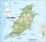
The Isle of Man
is an island
in the Irish Sea
, between Great Britain
and Ireland
in Western Europe
, with a population of over 75,000. It is a British Crown dependency
. It has a small islet
, the Calf of Man
, to its south. It is located at 54°15′N 4°30′W.
 Area:
Area:
total:
572 km²
land:
572 km²
water:
0 km²
This makes it:
of territorial waters, but only holds exclusive fishing rights in the first 3 miles.
Raad ny Foillan
long distance footpath runs 95 miles around the Manx
coast.
climate, with cool summers and mild winters. Average rainfall is high compared to the majority of the British Isles
, due to its location to the western side of Great Britain
and sufficient distance from Ireland
for moisture to be accumulated by the prevailing south-westerly winds. Average rainfall is highest at Snaefell
, where it is around 1900 mm (74.8 in) a year. At lower levels it can fall to around 800 mm (31.5 in) a year.
Temperatures remain fairly cool, with the recorded maximum being 28.9 °C (84 °F) at Ronaldsway
. The Isle of Man is known for its overcast
skies and low levels of sunshine, though the North of the Island is in a rain shadow and has higher levels of sunshine and lower rainfall.
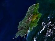
and Peel
. The highest point in the Isle of Man, Snaefell
, is in the northern area and reaches 620 metres (2,034 ft) above sea level
. The northern end of the island is a flat plain, consisting of glacial till
s and marine sediments. To the south the island is more hilly, with distinct valleys. There is no land below sea level.
. In recent years there has been a marked increase in the frequency of high winds, heavy rains, summer droughts and flood
ing both from heavy rain and from high seas. Snow
fall has decreased significantly over the past century while temperatures are increasing year round with rainfall decreasing.
Air pollution
, marine pollution
and waste
disposal are issues in the Isle of Man.
Global warming
and a sea level rise potentially pose a great threat to the Isle of Man
. All of the Island's towns are at threat from rising sea levels while the Northern Plain, a large, flat and low-lying plain
composed of soft marine sediments and glacial material, which makes up about a quarter of the Island's landmass
, is in danger of being lost to the sea over the next two centuries. The same is true for the considerably smaller Southern Plain surrounding the settlements of Castletown and Ballasalla
and including Ronaldsway Airport
http://www.gov.im/dlge/enviro/climatechange.xml.
Ramsar Sites
Shares an identical boundary to the Ballaugh Curraghs ASSI.
Marine Nature Reserve
None as of 30 January 2009, however there are Government plans for the first MNR to be designated by 2012.
Nature Reserves and Wildlife Sites
The Isle of Man now has forty-five non-statutory Wildlife Sites as of 30/01/09, covering approximately 195ha of land and an additional 10.5 km of inter-tidal coast. The Manx Wildlife Trust also manage 20 nature reserves.
Marine No-take Zones
See also Environment of the Isle of Man
age. There is a belt of younger Silurian
rocks along the west coast between Niarbyl and St Patrick's Isle
and a small area of Devonian
sandstones around Peel.
A band of Carboniferous
age rocks underlies part of the northern plain but is nowhere seen at the surface however similar age rocks do outcrop in the south between Castletown, Silverdale and Port St Mary. Permo-
Triassic
age rocks are known to lie beneath Point of Ayre but, as with the rest of the northern plain, these rocks are concealed by substantial thicknesses of superficial deposits.
The island has significant deposits of copper
, lead
and silver
, zinc
, iron, and plumbago (a mix of graphite
and clay
). There are also quarries of black marble
, limestone
flags, clay schist
, and granite
. These are all modern, and there was no noticeable exploitation of metals or minerals prior to the modern era.
in 2001, which recorded 76 315 people, itself a rise of 9.1% on the previous 1991 census.
The island's largest town and administrative centre is Douglas
, the population of which is 23 000, nearly a third of the entire population of the island. Neighbouring Onchan
, Ramsey
in the north, Peel in the west and the three southern ports of Castletown, Port Erin and Port St Mary are the island's other main settlements. Almost all its population lives on or very near to the coast.
Isle of Man
The Isle of Man , otherwise known simply as Mann , is a self-governing British Crown Dependency, located in the Irish Sea between the islands of Great Britain and Ireland, within the British Isles. The head of state is Queen Elizabeth II, who holds the title of Lord of Mann. The Lord of Mann is...
is an island
Island
An island or isle is any piece of sub-continental land that is surrounded by water. Very small islands such as emergent land features on atolls can be called islets, cays or keys. An island in a river or lake may be called an eyot , or holm...
in the Irish Sea
Irish Sea
The Irish Sea separates the islands of Ireland and Great Britain. It is connected to the Celtic Sea in the south by St George's Channel, and to the Atlantic Ocean in the north by the North Channel. Anglesey is the largest island within the Irish Sea, followed by the Isle of Man...
, between Great Britain
Great Britain
Great Britain or Britain is an island situated to the northwest of Continental Europe. It is the ninth largest island in the world, and the largest European island, as well as the largest of the British Isles...
and Ireland
Ireland
Ireland is an island to the northwest of continental Europe. It is the third-largest island in Europe and the twentieth-largest island on Earth...
in Western Europe
Western Europe
Western Europe is a loose term for the collection of countries in the western most region of the European continents, though this definition is context-dependent and carries cultural and political connotations. One definition describes Western Europe as a geographic entity—the region lying in the...
, with a population of over 75,000. It is a British Crown dependency
Crown dependency
The Crown Dependencies are British possessions of the Crown, as opposed to overseas territories of the United Kingdom. They comprise the Channel Island Bailiwicks of Jersey and Guernsey in the English Channel, and the Isle of Man in the Irish Sea....
. It has a small islet
Islet
An islet is a very small island.- Types :As suggested by its origin as islette, an Old French diminutive of "isle", use of the term implies small size, but little attention is given to drawing an upper limit on its applicability....
, the Calf of Man
Calf of Man
Calf of Man, sometimes known as the Calf of Mann , is a island , off the southwest coast of the Isle of Man. It is separated from the Isle of Man by a narrow stretch of water called the Calf Sound. Like the nearby rocky islets of Chicken Rock and Kitterland, it is part of the parish of Rushen. It...
, to its south. It is located at 54°15′N 4°30′W.
Dimensions
total:
572 km²
land:
572 km²
water:
0 km²
This makes it:
- slightly more than three times the size of Washington, DC
- slightly more than one third the size of HertfordshireHertfordshireHertfordshire is a ceremonial and non-metropolitan county in the East region of England. The county town is Hertford.The county is one of the Home Counties and lies inland, bordered by Greater London , Buckinghamshire , Bedfordshire , Cambridgeshire and...
- slightly smaller than Saint LuciaSaint LuciaSaint Lucia is an island country in the eastern Caribbean Sea on the boundary with the Atlantic Ocean. Part of the Lesser Antilles, it is located north/northeast of the island of Saint Vincent, northwest of Barbados and south of Martinique. It covers a land area of 620 km2 and has an...
.
Coast
The Isle of Man has a coastline of 160 km, and claims 12 nmNautical mile
The nautical mile is a unit of length that is about one minute of arc of latitude along any meridian, but is approximately one minute of arc of longitude only at the equator...
of territorial waters, but only holds exclusive fishing rights in the first 3 miles.
Raad ny Foillan
Raad ny Foillan
is a long distance footpath in the Isle of Man.-Route and history:The starts and finishes at the Millennium Bridge over Douglas Harbour...
long distance footpath runs 95 miles around the Manx
Isle of Man
The Isle of Man , otherwise known simply as Mann , is a self-governing British Crown Dependency, located in the Irish Sea between the islands of Great Britain and Ireland, within the British Isles. The head of state is Queen Elizabeth II, who holds the title of Lord of Mann. The Lord of Mann is...
coast.
Climate
The Isle of Man enjoys a temperateTemperate
In geography, temperate or tepid latitudes of the globe lie between the tropics and the polar circles. The changes in these regions between summer and winter are generally relatively moderate, rather than extreme hot or cold...
climate, with cool summers and mild winters. Average rainfall is high compared to the majority of the British Isles
British Isles
The British Isles are a group of islands off the northwest coast of continental Europe that include the islands of Great Britain and Ireland and over six thousand smaller isles. There are two sovereign states located on the islands: the United Kingdom of Great Britain and Northern Ireland and...
, due to its location to the western side of Great Britain
Great Britain
Great Britain or Britain is an island situated to the northwest of Continental Europe. It is the ninth largest island in the world, and the largest European island, as well as the largest of the British Isles...
and sufficient distance from Ireland
Ireland
Ireland is an island to the northwest of continental Europe. It is the third-largest island in Europe and the twentieth-largest island on Earth...
for moisture to be accumulated by the prevailing south-westerly winds. Average rainfall is highest at Snaefell
Snaefell
Snaefell is the highest mountain and the only summit higher than on the Isle of Man, at above sea level. The summit is crowned by a train station, cafe, and several communications masts.- Views :...
, where it is around 1900 mm (74.8 in) a year. At lower levels it can fall to around 800 mm (31.5 in) a year.
Temperatures remain fairly cool, with the recorded maximum being 28.9 °C (84 °F) at Ronaldsway
Ronaldsway
Ronaldsway is a place in Malew in the south of the Isle of Man, between the village of Ballasalla and the town of Castletown. It is notable as the location of Isle of Man Airport and historically RNAS Ronaldsway, together with the adjoining customs free zone and industrial estate.Ronaldsway is the...
. The Isle of Man is known for its overcast
Overcast
Overcast or overcast weather, as defined by the World Meteorological Organization, is the meteorological condition of clouds obscuring all of the sky. Overcast, written as "OVC" in the METAR observation, is reported when the cloud cover is observed to equal eight oktas .Sometimes clouds can be...
skies and low levels of sunshine, though the North of the Island is in a rain shadow and has higher levels of sunshine and lower rainfall.
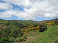
Terrain
The island's terrain is varied. There are two mountainous areas divided by a central valley which runs between DouglasDouglas, Isle of Man
right|thumb|250px|Douglas Promenade, which runs nearly the entire length of beachfront in Douglasright|thumb|250px|Sea terminal in DouglasDouglas is the capital and largest town of the Isle of Man, with a population of 26,218 people . It is located at the mouth of the River Douglas, and a sweeping...
and Peel
Peel
Peel or Peeling can refer to:* Peel , rind or skin-Places:* Peel Park * Peel Street Australia* Peel * Peel River * Peel Island, QueenslandCanada* Peel, New Brunswick...
. The highest point in the Isle of Man, Snaefell
Snaefell
Snaefell is the highest mountain and the only summit higher than on the Isle of Man, at above sea level. The summit is crowned by a train station, cafe, and several communications masts.- Views :...
, is in the northern area and reaches 620 metres (2,034 ft) above sea level
Above mean sea level
The term above mean sea level refers to the elevation or altitude of any object, relative to the average sea level datum. AMSL is used extensively in radio by engineers to determine the coverage area a station will be able to reach...
. The northern end of the island is a flat plain, consisting of glacial till
Till
thumb|right|Closeup of glacial till. Note that the larger grains in the till are completely surrounded by the matrix of finer material , and this characteristic, known as matrix support, is diagnostic of till....
s and marine sediments. To the south the island is more hilly, with distinct valleys. There is no land below sea level.
Land use
- Arable land: 9%
- Permanent crops: 0%
- Permanent pastures: 46%
- Forests and woodland: 6%
- Other: 39% (includes 25% mountain and heathland)
Natural hazards and environmental issues
There are few severe natural hazards, the most common being high winds, rough seas and dense fogFog
Fog is a collection of water droplets or ice crystals suspended in the air at or near the Earth's surface. While fog is a type of stratus cloud, the term "fog" is typically distinguished from the more generic term "cloud" in that fog is low-lying, and the moisture in the fog is often generated...
. In recent years there has been a marked increase in the frequency of high winds, heavy rains, summer droughts and flood
Flood
A flood is an overflow of an expanse of water that submerges land. The EU Floods directive defines a flood as a temporary covering by water of land not normally covered by water...
ing both from heavy rain and from high seas. Snow
Snow
Snow is a form of precipitation within the Earth's atmosphere in the form of crystalline water ice, consisting of a multitude of snowflakes that fall from clouds. Since snow is composed of small ice particles, it is a granular material. It has an open and therefore soft structure, unless packed by...
fall has decreased significantly over the past century while temperatures are increasing year round with rainfall decreasing.
Air pollution
Air pollution
Air pollution is the introduction of chemicals, particulate matter, or biological materials that cause harm or discomfort to humans or other living organisms, or cause damage to the natural environment or built environment, into the atmosphere....
, marine pollution
Marine pollution
Marine pollution occurs when harmful, or potentially harmful effects, can result from the entry into the ocean of chemicals, particles, industrial, agricultural and residential waste, noise, or the spread of invasive organisms. Most sources of marine pollution are land based...
and waste
Waste
Waste is unwanted or useless materials. In biology, waste is any of the many unwanted substances or toxins that are expelled from living organisms, metabolic waste; such as urea, sweat or feces. Litter is waste which has been disposed of improperly...
disposal are issues in the Isle of Man.
Global warming
Global warming
Global warming refers to the rising average temperature of Earth's atmosphere and oceans and its projected continuation. In the last 100 years, Earth's average surface temperature increased by about with about two thirds of the increase occurring over just the last three decades...
and a sea level rise potentially pose a great threat to the Isle of Man
Isle of Man
The Isle of Man , otherwise known simply as Mann , is a self-governing British Crown Dependency, located in the Irish Sea between the islands of Great Britain and Ireland, within the British Isles. The head of state is Queen Elizabeth II, who holds the title of Lord of Mann. The Lord of Mann is...
. All of the Island's towns are at threat from rising sea levels while the Northern Plain, a large, flat and low-lying plain
Plain
In geography, a plain is land with relatively low relief, that is flat or gently rolling. Prairies and steppes are types of plains, and the archetype for a plain is often thought of as a grassland, but plains in their natural state may also be covered in shrublands, woodland and forest, or...
composed of soft marine sediments and glacial material, which makes up about a quarter of the Island's landmass
Landmass
A landmass is a contiguous area of land surrounded by ocean. Although it may be most often written as one word to distinguish it from the usage "land mass"—the measure of land area—it is also used as two words.Landmasses include:*supercontinents...
, is in danger of being lost to the sea over the next two centuries. The same is true for the considerably smaller Southern Plain surrounding the settlements of Castletown and Ballasalla
Ballasalla
Ballasalla is a village in the parish of Malew in the south-east of the Isle of Man, close to the town of Castletown. The village was built mostly from the ruins of the nearby Rushen Abbey, a Cistercian abbey founded in the 12th century and dissolved in the 16th century.-Governance:The local...
and including Ronaldsway Airport
Isle of Man Airport
Isle of Man Airport , also known as Ronaldsway Airport and, in Manx, Purt Aer Vannin, is the main civilian airport on the Isle of Man. It is located in the south of the island at Ronaldsway near Castletown, southwest of Douglas, the island's capital. Along with the Isle of Man Sea Terminal, it is...
http://www.gov.im/dlge/enviro/climatechange.xml.
Protected Sites for Nature Conservation
In order of importance, international first, non-statutory last.Ramsar SitesRamsar ConventionThe Ramsar Convention is an international treaty for the conservation and sustainable utilization of wetlands, i.e., to stem the progressive encroachment on and loss of wetlands now and in the future, recognizing the fundamental ecological functions of wetlands and their economic, cultural,...
- Ballaugh Curraghs (2006, 183.86 ha)
Shares an identical boundary to the Ballaugh Curraghs ASSI.
Areas of Special Scientific Importance
There are 14 ASSIs on the Isle of Man as of 01/01/09.- The AyresPoint of AyreThe Point of Ayre is the northernmost point of the Isle of Man. It lies at the northern end of Ramsey Bay north of the town of Ramsey. The point can be accessed by the A16 road from Bride....
(1996, 272 ha) - Ballaugh Curraghs (2005, 183.86 ha)
- Rosehill Quarry, Billown
- Dhoon Glen (2007)
- Jurby AirfieldJurbyJurby is a parish in Micheal Sheading in the Isle of Man and has, according to the 2006 census 659 , residents.It is largely an agricultural district on the north-north-western coast of the island but also has an industrial park on the old RAF Jurby Airfield.The parish is one of three divisions of...
- Glen MayeGlen Mayeleft|thumb|250px|Waterfall in Glen MayeGlen Maye is a small village on the west coast of the Isle of Man, just south of Peel....
- Derbyhaven, Langness, SandwickDerbyhavenDerbyhaven is a hamlet near Castletown in the southern parish of Malew, Isle of Man. It is located on the isthmus connecting Langness Peninsula to the rest of the island, on the bay of the same name, and also on Castletown Bay on the other side of the isthmus.In the 17th century it was a...
Marine Nature ReserveMarine Nature ReserveMarine Nature Reserve is a British conservation designation officially awarded by the government to a marine reserve of national significance....
s
None as of 30 January 2009, however there are Government plans for the first MNR to be designated by 2012.Nature Reserves and Wildlife SitesNature reserveA nature reserve is a protected area of importance for wildlife, flora, fauna or features of geological or other special interest, which is reserved and managed for conservation and to provide special opportunities for study or research...
The Isle of Man now has forty-five non-statutory Wildlife Sites as of 30/01/09, covering approximately 195ha of land and an additional 10.5 km of inter-tidal coast. The Manx Wildlife Trust also manage 20 nature reserves.- Ballachurry
- Ballalough Reedbeds 1.4ha
- Ballamooar
- Ballanette
- Barnell Reservoir
- Breagle Glen (0.75 ac)
- Clay Head Brooghs
- Close-e-Quayle
- Close Sartfield (31 ac) (part of the Ballaugh Curraghs Ramsar Site)
- Close Umpson
- Cooildarry
- Cronk-y-Bing
- Curragh Feeagh
- Curragh Kionedroghad 1ha
- Curraghs Wildlife ParkCurraghs Wildlife ParkCurraghs Wildlife Park is a Wildlife Park, located in The Curraghs, , an area of wetland in the north-west of the Isle of Man....
(26 ac) - Dalby Mountain & Fields 28ha
- Earystane
- Fell's Field
- Gob ny Silvas
- Goshen (28 ac)(part of Ballaugh Curraghs Ramsar Site)
- Glen Dhoo (24.5 ac)
- Lough Cranstal
- Miss Gyler's Meadow
- Moaney & Crawyn's Meadows
- The Purt/Glen Dhoo
Marine No-take ZonesMarine Nature ReserveMarine Nature Reserve is a British conservation designation officially awarded by the government to a marine reserve of national significance....
- Bradda HeadBradda HeadBradda Head is a rugged headland in the south-west of the Isle of Man, in the British Isles, rising to a height of . It shelters Port Erin Bay from the north....
- Douglas Bay
See also Environment of the Isle of Man
Geology
The larger part of the island is formed from highly faulted and folded sedimentary rocks of OrdovicianOrdovician
The Ordovician is a geologic period and system, the second of six of the Paleozoic Era, and covers the time between 488.3±1.7 to 443.7±1.5 million years ago . It follows the Cambrian Period and is followed by the Silurian Period...
age. There is a belt of younger Silurian
Silurian
The Silurian is a geologic period and system that extends from the end of the Ordovician Period, about 443.7 ± 1.5 Mya , to the beginning of the Devonian Period, about 416.0 ± 2.8 Mya . As with other geologic periods, the rock beds that define the period's start and end are well identified, but the...
rocks along the west coast between Niarbyl and St Patrick's Isle
St Patrick's Isle
St Patrick's Isle is a small island off the Isle of Man in the Irish Sea, largely occupied by Peel Castle and noted for its attractive and relatively well preserved historic castle ruins. These ruins include St Patrick's Church and an Irish-style round tower, St German's Cathedral, and the more...
and a small area of Devonian
Devonian
The Devonian is a geologic period and system of the Paleozoic Era spanning from the end of the Silurian Period, about 416.0 ± 2.8 Mya , to the beginning of the Carboniferous Period, about 359.2 ± 2.5 Mya...
sandstones around Peel.
A band of Carboniferous
Carboniferous
The Carboniferous is a geologic period and system that extends from the end of the Devonian Period, about 359.2 ± 2.5 Mya , to the beginning of the Permian Period, about 299.0 ± 0.8 Mya . The name is derived from the Latin word for coal, carbo. Carboniferous means "coal-bearing"...
age rocks underlies part of the northern plain but is nowhere seen at the surface however similar age rocks do outcrop in the south between Castletown, Silverdale and Port St Mary. Permo-
Permian
The PermianThe term "Permian" was introduced into geology in 1841 by Sir Sir R. I. Murchison, president of the Geological Society of London, who identified typical strata in extensive Russian explorations undertaken with Edouard de Verneuil; Murchison asserted in 1841 that he named his "Permian...
Triassic
Triassic
The Triassic is a geologic period and system that extends from about 250 to 200 Mya . As the first period of the Mesozoic Era, the Triassic follows the Permian and is followed by the Jurassic. Both the start and end of the Triassic are marked by major extinction events...
age rocks are known to lie beneath Point of Ayre but, as with the rest of the northern plain, these rocks are concealed by substantial thicknesses of superficial deposits.
The island has significant deposits of copper
Copper
Copper is a chemical element with the symbol Cu and atomic number 29. It is a ductile metal with very high thermal and electrical conductivity. Pure copper is soft and malleable; an exposed surface has a reddish-orange tarnish...
, lead
Lead
Lead is a main-group element in the carbon group with the symbol Pb and atomic number 82. Lead is a soft, malleable poor metal. It is also counted as one of the heavy metals. Metallic lead has a bluish-white color after being freshly cut, but it soon tarnishes to a dull grayish color when exposed...
and silver
Silver
Silver is a metallic chemical element with the chemical symbol Ag and atomic number 47. A soft, white, lustrous transition metal, it has the highest electrical conductivity of any element and the highest thermal conductivity of any metal...
, zinc
Zinc
Zinc , or spelter , is a metallic chemical element; it has the symbol Zn and atomic number 30. It is the first element in group 12 of the periodic table. Zinc is, in some respects, chemically similar to magnesium, because its ion is of similar size and its only common oxidation state is +2...
, iron, and plumbago (a mix of graphite
Graphite
The mineral graphite is one of the allotropes of carbon. It was named by Abraham Gottlob Werner in 1789 from the Ancient Greek γράφω , "to draw/write", for its use in pencils, where it is commonly called lead . Unlike diamond , graphite is an electrical conductor, a semimetal...
and clay
Clay
Clay is a general term including many combinations of one or more clay minerals with traces of metal oxides and organic matter. Geologic clay deposits are mostly composed of phyllosilicate minerals containing variable amounts of water trapped in the mineral structure.- Formation :Clay minerals...
). There are also quarries of black marble
Marble
Marble is a metamorphic rock composed of recrystallized carbonate minerals, most commonly calcite or dolomite.Geologists use the term "marble" to refer to metamorphosed limestone; however stonemasons use the term more broadly to encompass unmetamorphosed limestone.Marble is commonly used for...
, limestone
Limestone
Limestone is a sedimentary rock composed largely of the minerals calcite and aragonite, which are different crystal forms of calcium carbonate . Many limestones are composed from skeletal fragments of marine organisms such as coral or foraminifera....
flags, clay schist
Schist
The schists constitute a group of medium-grade metamorphic rocks, chiefly notable for the preponderance of lamellar minerals such as micas, chlorite, talc, hornblende, graphite, and others. Quartz often occurs in drawn-out grains to such an extent that a particular form called quartz schist is...
, and granite
Granite
Granite is a common and widely occurring type of intrusive, felsic, igneous rock. Granite usually has a medium- to coarse-grained texture. Occasionally some individual crystals are larger than the groundmass, in which case the texture is known as porphyritic. A granitic rock with a porphyritic...
. These are all modern, and there was no noticeable exploitation of metals or minerals prior to the modern era.
Demographics
The island has a preliminary census estimated population of 79 805, as of September 2006. This is up on the government's last censusCensus
A census is the procedure of systematically acquiring and recording information about the members of a given population. It is a regularly occurring and official count of a particular population. The term is used mostly in connection with national population and housing censuses; other common...
in 2001, which recorded 76 315 people, itself a rise of 9.1% on the previous 1991 census.
The island's largest town and administrative centre is Douglas
Douglas, Isle of Man
right|thumb|250px|Douglas Promenade, which runs nearly the entire length of beachfront in Douglasright|thumb|250px|Sea terminal in DouglasDouglas is the capital and largest town of the Isle of Man, with a population of 26,218 people . It is located at the mouth of the River Douglas, and a sweeping...
, the population of which is 23 000, nearly a third of the entire population of the island. Neighbouring Onchan
Onchan
Onchan , is a village in the parish of Onchan on the Isle of Man. It is at the north end of Douglas Bay. Although administratively a village, it has the second largest population on the island, after Douglas, with which it forms a conurbation....
, Ramsey
Ramsey, Isle of Man
Ramsey is a town in the north of the Isle of Man. It is the second largest town on the island after Douglas. Its population is 7,309 according to the 2006 census . It has one of the biggest harbours on the island, and has a prominent derelict pier, called the Queen's Pier. It was formerly one of...
in the north, Peel in the west and the three southern ports of Castletown, Port Erin and Port St Mary are the island's other main settlements. Almost all its population lives on or very near to the coast.
See also
- Towns in the Isle of ManTowns in the Isle of ManThis is a list of places in the Isle of Man. In addition to the Isle of Man itself, the Isle of Man Government administers three small neighbouring islands: the Calf of Man, St Patrick's Isle and St Michael's Isle. There are four places with official status as towns, and three villages, as well as...
- List of rivers of the Isle of Man
- Climate change and the Isle of Man