
Point of Ayre
Encyclopedia
The Point of Ayre
is the northernmost point of the Isle of Man
. It lies at the northern end of Ramsey Bay
10 kilometres (6.2 mi) north of the town of Ramsey
. The point can be accessed by the A16 road from Bride.
It is the closest point on the Isle of Man to the British
Mainland, being 26 kilometres (16.2 mi) south of Burrow Head
in Scotland
.
The name Ayre comes from the Norse word Eyrr meaning gravel bank. Strong currents off-shore cause an ever changing build-up of shingle which literally means the beach changes shape with each tide, i.e. twice a day.
The considerable difference between high and low water at the Point of Ayre provides excellent fishing from the beach. Many visitors are attracted by the beautiful carpet of gorse and heather which surrounds the lighthouse and merges with sand dunes stretching to the south-west, providing cover for rare wild flowers and forming part of a Manx National Nature Reserve. A wide variety of land and sea birds visit the area throughout the year, as do a number of grey seals.
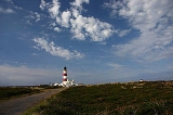
on the Isle of Man. It was designed and built by Robert Stevenson
, grandfather of prolific writer and novelist Robert Louis Stevenson
, and was first lit in 1818. The light has a nominal range of around 19 miles (30.6 km) at an elevation of 32 metres (105 ft). Painted with two distinctive red bands, the light can be seen clearly from across the water in south-west Scotland. Owing to the continuous accumulation of shingle and gravel deposited by the strong currents, a smaller light commonly referred to as a 'winkie' had to be built 750 feet (228.6 m) to the seaward side of the main tower in 1899. This was then repositioned a further 250 feet (76.2 m) in the same direction and for the same reasons in 1950.The 'winkie' light was discontinued on 7 April 2010
The lighthouse buildings and land have been in private ownership since 1993 when the light was fully automated. The light continues to be maintained by the Northern Lighthouse Board
based in Edinburgh. In August, 2005, the fog signal at the lighthouse was de-commissioned owing to the assumed reliance and availability of GPS and modern shipping guidance systems.
Ayre
Ayre is one of six sheadings in the Isle of Man and consists of the parishes of Andreas, Bride and Lezayre.Ayre is also a House of Keys constituency, electing a single MHK....
is the northernmost point of the Isle of Man
Isle of Man
The Isle of Man , otherwise known simply as Mann , is a self-governing British Crown Dependency, located in the Irish Sea between the islands of Great Britain and Ireland, within the British Isles. The head of state is Queen Elizabeth II, who holds the title of Lord of Mann. The Lord of Mann is...
. It lies at the northern end of Ramsey Bay
Ramsey Bay
Ramsey Bay is a large bay at the northeastern end of the Isle of Man. It runs for 18 kilometres from the Point of Ayre at the island's northern tip to Maughold Head...
10 kilometres (6.2 mi) north of the town of Ramsey
Ramsey, Isle of Man
Ramsey is a town in the north of the Isle of Man. It is the second largest town on the island after Douglas. Its population is 7,309 according to the 2006 census . It has one of the biggest harbours on the island, and has a prominent derelict pier, called the Queen's Pier. It was formerly one of...
. The point can be accessed by the A16 road from Bride.
It is the closest point on the Isle of Man to the British
Great Britain
Great Britain or Britain is an island situated to the northwest of Continental Europe. It is the ninth largest island in the world, and the largest European island, as well as the largest of the British Isles...
Mainland, being 26 kilometres (16.2 mi) south of Burrow Head
Burrow Head
Burrow Head is the southernmost tip of the Machars peninsula in south-west Scotland.It is located approximately two miles south-west of Isle of Whithorn, Wigtownshire and is the second southernmost point of Scotland ....
in Scotland
Scotland
Scotland is a country that is part of the United Kingdom. Occupying the northern third of the island of Great Britain, it shares a border with England to the south and is bounded by the North Sea to the east, the Atlantic Ocean to the north and west, and the North Channel and Irish Sea to the...
.
The name Ayre comes from the Norse word Eyrr meaning gravel bank. Strong currents off-shore cause an ever changing build-up of shingle which literally means the beach changes shape with each tide, i.e. twice a day.
The considerable difference between high and low water at the Point of Ayre provides excellent fishing from the beach. Many visitors are attracted by the beautiful carpet of gorse and heather which surrounds the lighthouse and merges with sand dunes stretching to the south-west, providing cover for rare wild flowers and forming part of a Manx National Nature Reserve. A wide variety of land and sea birds visit the area throughout the year, as do a number of grey seals.
Lighthouse
The Point of Ayre lighthouse is the oldest lighthouseLighthouse
A lighthouse is a tower, building, or other type of structure designed to emit light from a system of lamps and lenses or, in older times, from a fire, and used as an aid to navigation for maritime pilots at sea or on inland waterways....
on the Isle of Man. It was designed and built by Robert Stevenson
Robert Stevenson (civil engineer)
Robert Stevenson FRSE MInstCE FSAS MWS FGS FRAS FSA was a Scottish civil engineer and famed designer and builder of lighthouses.One of his finest achievements was the construction of the Bell Rock Lighthouse.-Early life:...
, grandfather of prolific writer and novelist Robert Louis Stevenson
Robert Louis Stevenson
Robert Louis Balfour Stevenson was a Scottish novelist, poet, essayist and travel writer. His best-known books include Treasure Island, Kidnapped, and Strange Case of Dr Jekyll and Mr Hyde....
, and was first lit in 1818. The light has a nominal range of around 19 miles (30.6 km) at an elevation of 32 metres (105 ft). Painted with two distinctive red bands, the light can be seen clearly from across the water in south-west Scotland. Owing to the continuous accumulation of shingle and gravel deposited by the strong currents, a smaller light commonly referred to as a 'winkie' had to be built 750 feet (228.6 m) to the seaward side of the main tower in 1899. This was then repositioned a further 250 feet (76.2 m) in the same direction and for the same reasons in 1950.The 'winkie' light was discontinued on 7 April 2010
The lighthouse buildings and land have been in private ownership since 1993 when the light was fully automated. The light continues to be maintained by the Northern Lighthouse Board
Northern Lighthouse Board
The Northern Lighthouse Board is the General Lighthouse Authority for Scotland and the Isle of Man. It is a non-departmental public body responsible for marine navigation aids around coastal areas.-History:...
based in Edinburgh. In August, 2005, the fog signal at the lighthouse was de-commissioned owing to the assumed reliance and availability of GPS and modern shipping guidance systems.