

Geography of Panama
Encyclopedia
Panama
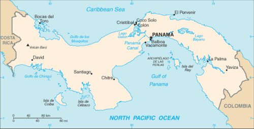
Panama , officially the Republic of Panama , is the southernmost country of Central America. Situated on the isthmus connecting North and South America, it is bordered by Costa Rica to the northwest, Colombia to the southeast, the Caribbean Sea to the north and the Pacific Ocean to the south. The...
is a country located in the Central America
Central America
Central America is the central geographic region of the Americas. It is the southernmost, isthmian portion of the North American continent, which connects with South America on the southeast. When considered part of the unified continental model, it is considered a subcontinent...
region of North America
North America
North America is a continent wholly within the Northern Hemisphere and almost wholly within the Western Hemisphere. It is also considered a northern subcontinent of the Americas...
, bordering both the Caribbean Sea
Caribbean Sea
The Caribbean Sea is a sea of the Atlantic Ocean located in the tropics of the Western hemisphere. It is bounded by Mexico and Central America to the west and southwest, to the north by the Greater Antilles, and to the east by the Lesser Antilles....
and the North Pacific Ocean
Pacific Ocean
The Pacific Ocean is the largest of the Earth's oceanic divisions. It extends from the Arctic in the north to the Southern Ocean in the south, bounded by Asia and Australia in the west, and the Americas in the east.At 165.2 million square kilometres in area, this largest division of the World...
, between Colombia
Colombia
Colombia, officially the Republic of Colombia , is a unitary constitutional republic comprising thirty-two departments. The country is located in northwestern South America, bordered to the east by Venezuela and Brazil; to the south by Ecuador and Peru; to the north by the Caribbean Sea; to the...
and Costa Rica
Costa Rica
Costa Rica , officially the Republic of Costa Rica is a multilingual, multiethnic and multicultural country in Central America, bordered by Nicaragua to the north, Panama to the southeast, the Pacific Ocean to the west and the Caribbean Sea to the east....
. Panama is located on the narrow and low Isthmus of Panama
Isthmus of Panama
The Isthmus of Panama, also historically known as the Isthmus of Darien, is the narrow strip of land that lies between the Caribbean Sea and the Pacific Ocean, linking North and South America. It contains the country of Panama and the Panama Canal...
. This S-shaped isthmus is situated between 7° and 10° north latitude
Latitude
In geography, the latitude of a location on the Earth is the angular distance of that location south or north of the Equator. The latitude is an angle, and is usually measured in degrees . The equator has a latitude of 0°, the North pole has a latitude of 90° north , and the South pole has a...
and 77° and 83° west longitude
Longitude
Longitude is a geographic coordinate that specifies the east-west position of a point on the Earth's surface. It is an angular measurement, usually expressed in degrees, minutes and seconds, and denoted by the Greek letter lambda ....
. Panama encompasses approximately 77,082 square kilometers, is 772 kilometers in length, and is between 60 and 177 kilometers in width.
Political map
The country is divided into 9 provinces, plus several indigenous comarcaComarca
A comarca is a traditional region or local administrative division found in parts of Spain, Portugal, Panama, Nicaragua, and Brazil. The term is derived from the term marca, meaning a "march, mark", plus the prefix co- meaning "together, jointly".The comarca is known in Aragonese as redolada and...
s. The provincial borders have not changed since they were determined at independence in 1903. The provinces are divided into districts, which in turn are subdivided into sections called corregimientos. Configurations of the corregimientos are changed periodically to accommodate population changes as revealed in the census reports.
The country's two international boundaries, with Colombia and Costa Rica, have been clearly demarcated, and in the late 1980s there were no outstanding disputes. The country claims the seabed of the continental shelf, which has been defined by Panama to extend to the 500-meter submarine contour. In addition, a 1958 law asserts jurisdiction over 12 nmi (22.2 km; 13.8 mi) from the coastlines, and in 1968 the government announced a claim to a 200 nmi (370.4 km; 230.2 mi) Exclusive Economic Zone
Exclusive Economic Zone
Under the law of the sea, an exclusive economic zone is a seazone over which a state has special rights over the exploration and use of marine resources, including production of energy from water and wind. It stretches from the seaward edge of the state's territorial sea out to 200 nautical...
.
Harbors
Almirante
Almirante is a city in the Bocas del Toro Province of the Republic of Panama. Its name is Spanish for Admiral.-Tourist Use:For travelers, Almirante is mainly used as a jumping off point for land travel to other cities on the mainland, Panama or to Costa Rica. An approximately 30-minute water taxi...
. The over 350 San Blas Islands
San Blas Islands
The San Blas Islands of Panama is an archipelago comprising approximately 378 islands and cays, of which only 49 are inhabited. They lay off the north coast of the Isthmus, east of the Panama Canal...
, near Colombia, are strung out for more than 160 kilometers along the sheltered Caribbean coastline.
The major port on the Pacific coastline is Balboa
Balboa, Panama
Balboa is a district of Panama City, located at the Pacific entrance to the Panama Canal.- History :The town of Balboa, founded by the United States during the construction of the Panama Canal, was named after Vasco Núñez de Balboa, the Spanish conquistador credited with discovering the Pacific Ocean...
. The principal islands are those of the Archipiélago de las Perlas in the middle of the Gulf of Panama
Gulf of Panama
The Gulf of Panama is a gulf in the Pacific Ocean, near the southern coast of Panama. It has a maximum width of , a maximum depth of and the size of . The Panama Canal connects the Gulf of Panama with the Caribbean Sea and the Atlantic Ocean...
, the penal colony on the Isla de Coiba in the Golfo de Chiriquí, and the decorative island of Taboga, a tourist attraction that can be seen from Panama City. In all, there are some 1,000 islands off the Pacific coast.
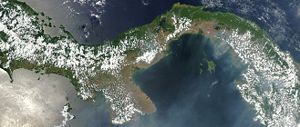
The Pacific coastal waters are extraordinarily shallow. Depths of 180 meters are reached only outside the perimeters of both the Gulf of Panama and the Golfo de Chiriquí, and wide mud flats extend up to 70 kilometers seaward from the coastlines. As a consequence, the tidal range is extreme. A variation of about 70 centimeters between high and low water on the Caribbean coast contrasts sharply with over 700 centimeters on the Pacific coast, and some 130 kilometers up the Río Tuira the range is still over 500 centimeters.
Elevation
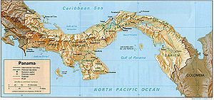
Andes
The Andes is the world's longest continental mountain range. It is a continual range of highlands along the western coast of South America. This range is about long, about to wide , and of an average height of about .Along its length, the Andes is split into several ranges, which are separated...
system of South America. The spine that forms the divide is the highly eroded arch of an uplift from the sea bottom, in which peaks were formed by volcanic intrusions.
The mountain range of the divide is called the Cordillera de Talamanca
Cordillera de Talamanca
The Cordillera de Talamanca is a mountain range that lies on the border between Costa Rica and Panama. Much of the range and the area around it is included in the La Amistad International Park, which also is shared between the two countries....
near the Costa Rican border. Farther east it becomes the Serranía de Tabasará, and the portion of it closer to the lower saddle of the isthmus, where the canal is located, is often called the Sierra de Veraguas. As a whole, the range between Costa Rica and the canal is generally referred to by Panamanian geographers as the Cordillera Central
Cordillera Central, Costa Rica
The Cordillera Central is a volcanic mountain range in central Costa Rica which continues the Continental Divide east of Cordillera de Tilarán. It extends 80 km from Tapezco Pass to the Turrialba Volcano and ending on the Pacuare River...
.
The highest point in the country is the Volcán Barú
Volcán Barú
The Volcán Barú is the tallest mountain in Panama and is high. It lies about 35 km off the border of Costa Rica....
(formerly known as the Volcán de Chiriquí), which rises to 3475 meters. The apex of a highland that includes the nation's richest soil, the Volcán Barú is still referred to as a volcano, although it has been inactive for millennia. It offers a view of both the Pacific Ocean
Pacific Ocean
The Pacific Ocean is the largest of the Earth's oceanic divisions. It extends from the Arctic in the north to the Southern Ocean in the south, bounded by Asia and Australia in the west, and the Americas in the east.At 165.2 million square kilometres in area, this largest division of the World...
and the Atlantic Ocean
Atlantic Ocean
The Atlantic Ocean is the second-largest of the world's oceanic divisions. With a total area of about , it covers approximately 20% of the Earth's surface and about 26% of its water surface area...
.
Waterways
Nearly 500 rivers lace Panama's rugged landscape. Mostly unnavigable, many originate as swift highland streams, meander in valleys, and form coastal deltas. However, the Río Chepo and the Río Chagres are sources of hydroelectric power. The Kampia lake and Madden Lake (also filled with water from the Río Chagres) provide hydroelectricity for the area of the former Canal Zone.The Río Chepo, another major source of hydroelectric power, is one of the more than 300 rivers emptying into the Pacific. These Pacific-oriented rivers are longer and slower running than those of the Caribbean side. Their basins are also more extensive. One of the longest is the Río Tuira which flows into the Golfo de San Miguel and is the nation's only river navigable by larger vessels.
Climate
Temperatures on the Pacific side of the isthmus are somewhat lower than on the Caribbean, and breezes tend to rise after dusk in most parts of the country. Temperatures are markedly cooler in the higher parts of the mountain ranges, and frosts occur in the Cordillera de Talamanca in western Panama.
Climatic regions are determined less on the basis of temperature than on rainfall, which varies regionally from less than 1300 millimetres (51.2 in) to more than 3000 millimetres (118.1 in) per year. Almost all of the rain falls during the rainy season, which is usually from May through November, but varies in length from seven to nine months. The cycle of rainfall is determined primarily by two factors: moisture from the Caribbean, which is transported by north and northeast winds prevailing during most of the year, and the continental divide, which acts as a rainshield for the Pacific lowlands. A third influence that is present during the late autumn is the southwest wind off the Pacific. This wind brings some precipitation to the Pacific lowlands, modified by the highlands of the Península de Azuero, which form a partial rainshield for much of central Panama. In general, rainfall is much heavier on the Caribbean than on the Pacific side of the continental divide. The annual average in Panama City is little more than half of that in Colón. Although rainy-season thunderstorms are common, the country is outside the hurricane belt
Hurricane belt
The hurricane belt is an area in the Atlantic Ocean, including the Caribbean Sea and Gulf of Mexico, which is prone to hurricanes during the Atlantic hurricane season....
.
Fauna and flora
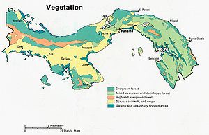
Mangrove
Mangroves are various kinds of trees up to medium height and shrubs that grow in saline coastal sediment habitats in the tropics and subtropics – mainly between latitudes N and S...
swamps occur along parts of both coasts, with banana
Banana
Banana is the common name for herbaceous plants of the genus Musa and for the fruit they produce. Bananas come in a variety of sizes and colors when ripe, including yellow, purple, and red....
plantations occupying deltas near Costa Rica. In many places, a multi-canopied rain forest abuts the swamp on one side of the country and largens
to the lower reaches of slopes in the other.
General facts
Geographic coordinates: 9°00′N 80°00′WMap references:
Central America and the Caribbean
Caribbean
The Caribbean is a crescent-shaped group of islands more than 2,000 miles long separating the Gulf of Mexico and the Caribbean Sea, to the west and south, from the Atlantic Ocean, to the east and north...
Area:
total: 78,200 km²
land:
75,990 km²
water:
2,210 km²
Land boundaries:
total:
555 km
border countries:
Colombia 225 km, Costa Rica 330 km
Coastline:
2,490 km
Maritime claims:
contiguous zone:
24 nautical miles (44 km)
exclusive economic zone:
200 nautical miles (370 km)
territorial sea:
12 nautical miles (22 km)
Climate:
tropical maritime; hot, humid, cloudy; prolonged rainy season (May to January), short dry season (January to May)
Terrain:
interior mostly steep, rugged mountains and dissected, upland plains; coastal areas largely plains and rolling hills
Elevation extremes:
lowest point:
Pacific Ocean 0 m
highest point:
Volcan de Chiriqui 3,475 m
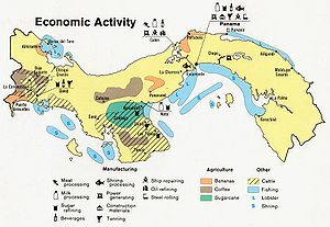
Natural resources:
copper
Copper
Copper is a chemical element with the symbol Cu and atomic number 29. It is a ductile metal with very high thermal and electrical conductivity. Pure copper is soft and malleable; an exposed surface has a reddish-orange tarnish...
, mahogany forests, shrimp
Shrimp
Shrimp are swimming, decapod crustaceans classified in the infraorder Caridea, found widely around the world in both fresh and salt water. Adult shrimp are filter feeding benthic animals living close to the bottom. They can live in schools and can swim rapidly backwards. Shrimp are an important...
, hydropower
Hydropower
Hydropower, hydraulic power, hydrokinetic power or water power is power that is derived from the force or energy of falling water, which may be harnessed for useful purposes. Since ancient times, hydropower has been used for irrigation and the operation of various mechanical devices, such as...
Land use:
arable land:
7%
permanent crops:
2%
permanent pastures:
20%
forests and woodland:
44%
other:
27% (1993 est.)
Irrigated land:
320 km² (1993 est.)
Natural hazards:
occasional severe storms and forest fires in the Darien area, earthquakes
Environment - current issues:
water pollution
Water pollution
Water pollution is the contamination of water bodies . Water pollution occurs when pollutants are discharged directly or indirectly into water bodies without adequate treatment to remove harmful compounds....
from agricultural runoff threatens fishery resources; deforestation of tropical rain forest; land degradation and soil erosion threatens siltation of Panama Canal
Panama Canal
The Panama Canal is a ship canal in Panama that joins the Atlantic Ocean and the Pacific Ocean and is a key conduit for international maritime trade. Built from 1904 to 1914, the canal has seen annual traffic rise from about 1,000 ships early on to 14,702 vessels measuring a total of 309.6...
Environment - international agreements:
party to:
Biodiversity
Biodiversity
Biodiversity is the degree of variation of life forms within a given ecosystem, biome, or an entire planet. Biodiversity is a measure of the health of ecosystems. Biodiversity is in part a function of climate. In terrestrial habitats, tropical regions are typically rich whereas polar regions...
, Climate Change
United Nations Framework Convention on Climate Change
The United Nations Framework Convention on Climate Change is an international environmental treaty produced at the United Nations Conference on Environment and Development , informally known as the Earth Summit, held in Rio de Janeiro from June 3 to 14, 1992...
, Climate Change-Kyoto Protocol, Desertification
Desertification
Desertification is the degradation of land in drylands. Caused by a variety of factors, such as climate change and human activities, desertification is one of the most significant global environmental problems.-Definitions:...
, Endangered Species
Endangered species
An endangered species is a population of organisms which is at risk of becoming extinct because it is either few in numbers, or threatened by changing environmental or predation parameters...
, Hazardous Wastes, Law of the Sea
Law of the sea
Law of the sea may refer to:* United Nations Convention on the Law of the Sea* Admiralty law* The Custom of the Sea...
, Marine Dumping, Nuclear Test Ban, Ozone Layer Protection, Ship Pollution, Tropical Timber 83, Tropical Timber 94, Wetlands, Whaling
Whaling
Whaling is the hunting of whales mainly for meat and oil. Its earliest forms date to at least 3000 BC. Various coastal communities have long histories of sustenance whaling and harvesting beached whales...
signed, but not ratified:
Marine Life Conservation
Geography - note:
strategic location at eastern end of Central America; controls Panama Canal that links Atlantic Ocean via Caribbean Sea with Pacific Ocean. Central Panama has the unique distinction of having the sun rise over the Pacific and set over the Atlantic.