

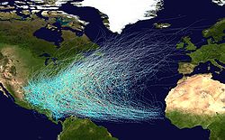
Hurricane belt
Encyclopedia
Atlantic Ocean
The Atlantic Ocean is the second-largest of the world's oceanic divisions. With a total area of about , it covers approximately 20% of the Earth's surface and about 26% of its water surface area...
, including the Caribbean Sea
Caribbean Sea
The Caribbean Sea is a sea of the Atlantic Ocean located in the tropics of the Western hemisphere. It is bounded by Mexico and Central America to the west and southwest, to the north by the Greater Antilles, and to the east by the Lesser Antilles....
and Gulf of Mexico
Gulf of Mexico
The Gulf of Mexico is a partially landlocked ocean basin largely surrounded by the North American continent and the island of Cuba. It is bounded on the northeast, north and northwest by the Gulf Coast of the United States, on the southwest and south by Mexico, and on the southeast by Cuba. In...
, which is prone to hurricanes during the Atlantic hurricane season
Atlantic hurricane season
The Atlantic hurricane season is the period in a year when hurricanes usually form in the Atlantic Ocean. Tropical cyclones in the North Atlantic are called hurricanes, tropical storms, or tropical depressions. In addition, there have been several storms over the years that have not been fully...
.
The only inhabited Caribbean islands not in the hurricane belt are Barbados
Barbados
Barbados is an island country in the Lesser Antilles. It is in length and as much as in width, amounting to . It is situated in the western area of the North Atlantic and 100 kilometres east of the Windward Islands and the Caribbean Sea; therein, it is about east of the islands of Saint...
, Grenada
Grenada
Grenada is an island country and Commonwealth Realm consisting of the island of Grenada and six smaller islands at the southern end of the Grenadines in the southeastern Caribbean Sea...
, Trinidad and Tobago
Trinidad and Tobago
Trinidad and Tobago officially the Republic of Trinidad and Tobago is an archipelagic state in the southern Caribbean, lying just off the coast of northeastern Venezuela and south of Grenada in the Lesser Antilles...
, Bonaire, Curaçao
Curaçao
Curaçao is an island in the southern Caribbean Sea, off the Venezuelan coast. The Country of Curaçao , which includes the main island plus the small, uninhabited island of Klein Curaçao , is a constituent country of the Kingdom of the Netherlands...
, Aruba
Aruba
Aruba is a 33 km-long island of the Lesser Antilles in the southern Caribbean Sea, located 27 km north of the coast of Venezuela and 130 km east of Guajira Peninsula...
, Providencia Island
Providencia Island
Isla de Providencia or Old Providence is a mountainous Caribbean island. Though it is closer to Nicaragua, it is part of the Archipelago of San Andres, Providencia and Santa Catalina, a department of Colombia, lying midway between Costa Rica and Jamaica...
, San Andrés
San Andrés (island)
San Andrés is a coral island among the Colombian islands in the Caribbean Sea; it is the largest island of the southern group of islands. Together with the nearby island of Providencia and some smaller islands of the southern group of the Colombian archipelago, San Andrés forms the department of...
, and the islands off Venezuela
Federal dependencies of Venezuela
The Federal Dependencies of Venezuela encompass all of Venezuela's off shore islands in the Caribbean Sea and the Gulf of Venezuela...
.
According to an Azores High
Azores High
The Azores High is a large subtropical semi-permanent centre of high atmospheric pressure found near the Azores in the Atlantic Ocean, at the Horse latitudes...
hypothesis of geographer Kam-biu Liu, an anti-phase pattern is expected to exist between the Gulf of Mexico
Gulf of Mexico
The Gulf of Mexico is a partially landlocked ocean basin largely surrounded by the North American continent and the island of Cuba. It is bounded on the northeast, north and northwest by the Gulf Coast of the United States, on the southwest and south by Mexico, and on the southeast by Cuba. In...
coast and the North American Atlantic coast
Atlantic Seaboard
The Atlantic seaboard watershed is a watershed of North America along both*the Atlantic Canada coast south of the Gulf of Saint Lawrence Watershed &*the East Coast of the United States north of the watershed of the Okeechobee Waterway....
. During the quiescent periods (3000–1400 BC, and 1000 AD to present), a more northeasterly position of the Azores High would result in more hurricanes being steered towards the Atlantic coast. During the hyperactive period (1400 BC to 1000 AD), more hurricanes were steered towards the Gulf coast as the Azores High was shifted to a more southwesterly position near the Caribbean. Such a displacement of the Azores High is consistent with paleoclimatic evidence that shows an abrupt onset of a drier climate in Haiti
Haiti
Haiti , officially the Republic of Haiti , is a Caribbean country. It occupies the western, smaller portion of the island of Hispaniola, in the Greater Antillean archipelago, which it shares with the Dominican Republic. Ayiti was the indigenous Taíno or Amerindian name for the island...
around 3200 14C
Radiocarbon dating
Radiocarbon dating is a radiometric dating method that uses the naturally occurring radioisotope carbon-14 to estimate the age of carbon-bearing materials up to about 58,000 to 62,000 years. Raw, i.e. uncalibrated, radiocarbon ages are usually reported in radiocarbon years "Before Present" ,...
years BP, and a change towards more humid conditions in the Great Plains
Great Plains
The Great Plains are a broad expanse of flat land, much of it covered in prairie, steppe and grassland, which lies west of the Mississippi River and east of the Rocky Mountains in the United States and Canada. This area covers parts of the U.S...
during the late-Holocene
Holocene
The Holocene is a geological epoch which began at the end of the Pleistocene and continues to the present. The Holocene is part of the Quaternary period. Its name comes from the Greek words and , meaning "entirely recent"...
as more moisture was pumped up the Mississippi Valley through the Gulf coast. Preliminary data from the northern Atlantic coast seem to support the Azores High hypothesis. A 3000-year proxy record from a coastal lake in Cape Cod
Cape Cod
Cape Cod, often referred to locally as simply the Cape, is a cape in the easternmost portion of the state of Massachusetts, in the Northeastern United States...
suggests that hurricane activity has increased significantly during the past 500–1000 years, just as the Gulf coast was amid a quiescent period of the last millennium.