
Geography of North Korea
Encyclopedia
North Korea
The Democratic People’s Republic of Korea , , is a country in East Asia, occupying the northern half of the Korean Peninsula. Its capital and largest city is Pyongyang. The Korean Demilitarized Zone serves as the buffer zone between North Korea and South Korea...
is located in east Asia
East Asia
East Asia or Eastern Asia is a subregion of Asia that can be defined in either geographical or cultural terms...
on the northern half of the Korean Peninsula
Korean Peninsula
The Korean Peninsula is a peninsula in East Asia. It extends southwards for about 684 miles from continental Asia into the Pacific Ocean and is surrounded by the Sea of Japan to the south, and the Yellow Sea to the west, the Korea Strait connecting the first two bodies of water.Until the end of...
. North Korea
North Korea
The Democratic People’s Republic of Korea , , is a country in East Asia, occupying the northern half of the Korean Peninsula. Its capital and largest city is Pyongyang. The Korean Demilitarized Zone serves as the buffer zone between North Korea and South Korea...
shares a border with three states, including China
People's Republic of China
China , officially the People's Republic of China , is the most populous country in the world, with over 1.3 billion citizens. Located in East Asia, the country covers approximately 9.6 million square kilometres...
along the Amnok River, Russia
Russia
Russia or , officially known as both Russia and the Russian Federation , is a country in northern Eurasia. It is a federal semi-presidential republic, comprising 83 federal subjects...
along the Duman River, and South Korea
South Korea
The Republic of Korea , , is a sovereign state in East Asia, located on the southern portion of the Korean Peninsula. It is neighbored by the People's Republic of China to the west, Japan to the east, North Korea to the north, and the East China Sea and Republic of China to the south...
along the Korean Demilitarized Zone
Korean Demilitarized Zone
The Korean Demilitarized Zone is a strip of land running across the Korean Peninsula that serves as a buffer zone between North and South Korea. The DMZ cuts the Korean Peninsula roughly in half, crossing the 38th parallel on an angle, with the west end of the DMZ lying south of the parallel and...
(DMZ). The Yellow Sea
Yellow Sea
The Yellow Sea is the name given to the northern part of the East China Sea, which is a marginal sea of the Pacific Ocean. It is located between mainland China and the Korean Peninsula. Its name comes from the sand particles from Gobi Desert sand storms that turn the surface of the water golden...
and the Korea Bay
Korea Bay
The Korea Bay is a northern extension of the Yellow Sea, between Liaoning Province of China and North P'yŏngan Province of North Korea.It is separated from the Bohai Sea by the Liaodong Peninsula, with Dalian at its southernmost point...
are off the west coast and the Sea of Japan
Sea of Japan
The Sea of Japan is a marginal sea of the western Pacific Ocean, between the Asian mainland, the Japanese archipelago and Sakhalin. It is bordered by Japan, North Korea, Russia and South Korea. Like the Mediterranean Sea, it has almost no tides due to its nearly complete enclosure from the Pacific...
(East Sea of Korea) is off the east coast.
Boundaries, coastline, and islands
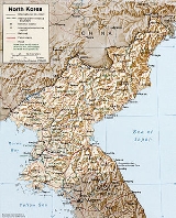
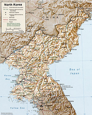
40°00′N 127°00′ENorth Korea has an area of 120,540 km², of which 120,410 km² is land and 130 km² is water. It has 1673 km of land boundaries; of these, 1416 km are with China, 238 km are with South Korea, and 19 km are with Russia.
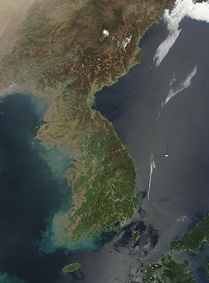
The Korean Peninsula extends about 1000 km southward from the northeast Asian continental landmass. The 8460-km coastline of Korea
Korea
Korea ) is an East Asian geographic region that is currently divided into two separate sovereign states — North Korea and South Korea. Located on the Korean Peninsula, Korea is bordered by the People's Republic of China to the northwest, Russia to the northeast, and is separated from Japan to the...
is highly irregular, and North Korea accounts for 2495 km of this, roughly half. Some 3579 island
Island
An island or isle is any piece of sub-continental land that is surrounded by water. Very small islands such as emergent land features on atolls can be called islets, cays or keys. An island in a river or lake may be called an eyot , or holm...
s lie adjacent to the Korean Peninsula, mostly along the south and west coasts.
Maritime claims
The North Korean government claims territorial watersTerritorial waters
Territorial waters, or a territorial sea, as defined by the 1982 United Nations Convention on the Law of the Sea, is a belt of coastal waters extending at most from the baseline of a coastal state...
extending 12 nmi (22.2 km; 13.8 mi) from shore. It also claims an exclusive economic zone
Exclusive Economic Zone
Under the law of the sea, an exclusive economic zone is a seazone over which a state has special rights over the exploration and use of marine resources, including production of energy from water and wind. It stretches from the seaward edge of the state's territorial sea out to 200 nautical...
200 nmi (370.4 km; 230.2 mi) from shore. In addition, a maritime military boundary that lies 50 nmi (92.6 km; 57.5 mi) offshore in the Sea of Japan and 200 nmi (370.4 km; 230.2 mi) offshore in the Yellow Sea demarcates the waters and airspace into which foreign ships and planes are prohibited from entering without permission.
Waters of the Yellow Sea are demarcated between North Korea and South Korea by the disputed Northern Limit Line
Northern Limit Line
The Northern Limit Line or North Limit Line is a disputed inter-Korea maritime demarcation line in the Yellow Sea between the Democratic People's Republic of Korea on the north, and the Republic of Korea on the south...
drawn by the United Nations Command (Korea)
United Nations Command (Korea)
The United Nations Command is the unified command structure for the multinational military forces supporting the Republic of Korea during and after the Korean War...
in early 1950s and not officially recognized by North Korea.
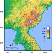
Topography and drainage
Hill
A hill is a landform that extends above the surrounding terrain. Hills often have a distinct summit, although in areas with scarp/dip topography a hill may refer to a particular section of flat terrain without a massive summit A hill is a landform that extends above the surrounding terrain. Hills...
s and mountain
Mountain
Image:Himalaya_annotated.jpg|thumb|right|The Himalayan mountain range with Mount Everestrect 58 14 160 49 Chomo Lonzorect 200 28 335 52 Makalurect 378 24 566 45 Mount Everestrect 188 581 920 656 Tibetan Plateaurect 250 406 340 427 Rong River...
s separated by deep, narrow valley
Valley
In geology, a valley or dale is a depression with predominant extent in one direction. A very deep river valley may be called a canyon or gorge.The terms U-shaped and V-shaped are descriptive terms of geography to characterize the form of valleys...
s. The coastal plain
Plain
In geography, a plain is land with relatively low relief, that is flat or gently rolling. Prairies and steppes are types of plains, and the archetype for a plain is often thought of as a grassland, but plains in their natural state may also be covered in shrublands, woodland and forest, or...
s are wide in the west and discontinuous in the east.
Elevation extremes
- Lowest point: Sea of Japan, 0 m (sea levelSea levelMean sea level is a measure of the average height of the ocean's surface ; used as a standard in reckoning land elevation...
) - Highest point: Baekdu MountainBaekdu MountainBaekdu Mountain, also known in China as Changbai Mountain and Baitou Mountain , is a volcanic mountain on the border between North Korea and China, located at...
(Paektusan), 2744 m
Early Europe
Europe
Europe is, by convention, one of the world's seven continents. Comprising the westernmost peninsula of Eurasia, Europe is generally 'divided' from Asia to its east by the watershed divides of the Ural and Caucasus Mountains, the Ural River, the Caspian and Black Seas, and the waterways connecting...
an visitors to Korea remarked that the country resembled "a sea in a heavy gale" because of the many successive mountain range
Mountain range
A mountain range is a single, large mass consisting of a succession of mountains or narrowly spaced mountain ridges, with or without peaks, closely related in position, direction, formation, and age; a component part of a mountain system or of a mountain chain...
s that crisscross the peninsula. Some 80 percent of North Korea's land area is composed of mountains and uplands, with all of the peninsula's mountains with elevations of 2000 m or more located in North Korea. The great majority of the population lives in the plains and lowlands.
Baekdu Mountain
Baekdu Mountain
Baekdu Mountain, also known in China as Changbai Mountain and Baitou Mountain , is a volcanic mountain on the border between North Korea and China, located at...
, the highest point in North Korea, is a volcanic mountain
Volcano
2. Bedrock3. Conduit 4. Base5. Sill6. Dike7. Layers of ash emitted by the volcano8. Flank| 9. Layers of lava emitted by the volcano10. Throat11. Parasitic cone12. Lava flow13. Vent14. Crater15...
near the Chinese border with basalt
Basalt
Basalt is a common extrusive volcanic rock. It is usually grey to black and fine-grained due to rapid cooling of lava at the surface of a planet. It may be porphyritic containing larger crystals in a fine matrix, or vesicular, or frothy scoria. Unweathered basalt is black or grey...
lava
Lava
Lava refers both to molten rock expelled by a volcano during an eruption and the resulting rock after solidification and cooling. This molten rock is formed in the interior of some planets, including Earth, and some of their satellites. When first erupted from a volcanic vent, lava is a liquid at...
plateau
Plateau
In geology and earth science, a plateau , also called a high plain or tableland, is an area of highland, usually consisting of relatively flat terrain. A highly eroded plateau is called a dissected plateau...
with elevations between 1400 and 2000 m above sea level. The Hamgyeong Range, located in the extreme northeastern part of the peninsula, has many high peaks, including Mt. Gwanmosan at approximately 1756 m.
Other major ranges include the Rangrim Mountains, which are located in the north-central part of North Korea and run in a north-south direction, making communication between the eastern and western parts of the country rather difficult; and the Kangnam Range, which runs along the North Korea–China border. Geumgangsan, often written Mt Kumgang, or Diamond Mountain, (approximately 1,638 m) in the Taebaek
Taebaek Mountains
The Taebaek Mountains are a mountain range in both North Korea and South Korea. They form the main ridge of the Korean peninsula.-Geography:...
Range, which extends into South Korea, is famous for its scenic beauty.
For the most part, the plains are small. The most extensive are the Pyeongyang and Chaeryŏng
Chaeryong
-Geography:Located on the Chaeryŏng River, the county is bordered to the west by Anak and Sinch'ŏn, to the south by Sinwŏn, and to the east by Ŭnp'a, Pongsan and Sariwŏn in North Hwanghae Province.-History:...
plains, each covering about 500 km2. Because the mountains on the east coast drop abruptly to the sea, the plains are even smaller there than on the west coast.
The mountain ranges in the northern and eastern parts of North Korea form the watershed for most of its rivers, which run in a westerly direction and empty into the Yellow Sea and Korea Bay. The longest is the Amnok River, which is navigable for 678 of its 790 km. The Duman River, one of the few major rivers to flow into the Sea of Japan, is the second longest at 521 kilometers but is navigable for only 85 kilometers because of the mountainous topography.
The third longest river, the Daedong River, flows through Pyeongyang and is navigable for 245 of its 397 km. Lakes tend to be small because of the lack of glacial activity and the stability of the Earth's crust in the region. Unlike neighboring Japan or northern China, North Korea experiences few severe earthquake
Earthquake
An earthquake is the result of a sudden release of energy in the Earth's crust that creates seismic waves. The seismicity, seismism or seismic activity of an area refers to the frequency, type and size of earthquakes experienced over a period of time...
s. The country is well-endowed with spas and hot springs, which number 124 according to one North Korean source.
Climate
See also: North Korea#Climate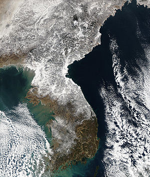
Continental climate
Continental climate is a climate characterized by important annual variation in temperature due to the lack of significant bodies of water nearby...
with four distinct seasons. Long winters bring bitter cold and clear weather interspersed with snow storms as a result of northern and northwestern winds that blow from Siberia
Siberia
Siberia is an extensive region constituting almost all of Northern Asia. Comprising the central and eastern portion of the Russian Federation, it was part of the Soviet Union from its beginning, as its predecessor states, the Tsardom of Russia and the Russian Empire, conquered it during the 16th...
. The daily average high and low temperatures for P'yongyang in January are -3 °C. On average, it snows thirty-seven days during the winter. Winter can be particularly harsh in the northern, mountainous regions. Summer tends to be short, hot, humid, and rainy because of the southern and southeastern monsoon
Monsoon
Monsoon is traditionally defined as a seasonal reversing wind accompanied by corresponding changes in precipitation, but is now used to describe seasonal changes in atmospheric circulation and precipitation associated with the asymmetric heating of land and sea...
winds that bring moist air from the Pacific Ocean
Pacific Ocean
The Pacific Ocean is the largest of the Earth's oceanic divisions. It extends from the Arctic in the north to the Southern Ocean in the south, bounded by Asia and Australia in the west, and the Americas in the east.At 165.2 million square kilometres in area, this largest division of the World...
.
The daily average high and low temperatures for Pyongyang
Pyongyang
Pyongyang is the capital of the Democratic People's Republic of Korea, commonly known as North Korea, and the largest city in the country. Pyongyang is located on the Taedong River and, according to preliminary results from the 2008 population census, has a population of 3,255,388. The city was...
in August are 29 and 20 °C (84.2 and 68 °F). On average, approximately 60% of all precipitation occurs from June to September. Typhoons affect the peninsula on an average of at least once every summer. Spring and autumn are transitional seasons marked by mild temperatures and variable winds and bring the most pleasant weather.
Natural hazards include late spring drought
Drought
A drought is an extended period of months or years when a region notes a deficiency in its water supply. Generally, this occurs when a region receives consistently below average precipitation. It can have a substantial impact on the ecosystem and agriculture of the affected region...
s which often are followed by severe flood
Flood
A flood is an overflow of an expanse of water that submerges land. The EU Floods directive defines a flood as a temporary covering by water of land not normally covered by water...
ing. There are occasional typhoons during the early fall.
Environmental protection
Environment – current issues: localized air pollutionAir pollution
Air pollution is the introduction of chemicals, particulate matter, or biological materials that cause harm or discomfort to humans or other living organisms, or cause damage to the natural environment or built environment, into the atmosphere....
attributable to inadequate industrial controls; water pollution
Water pollution
Water pollution is the contamination of water bodies . Water pollution occurs when pollutants are discharged directly or indirectly into water bodies without adequate treatment to remove harmful compounds....
; inadequate supplies of potable water; deforestation
Deforestation
Deforestation is the removal of a forest or stand of trees where the land is thereafter converted to a nonforest use. Examples of deforestation include conversion of forestland to farms, ranches, or urban use....
.
Environment – international agreements: party to: Antarctic Treaty, Biodiversity
Biodiversity
Biodiversity is the degree of variation of life forms within a given ecosystem, biome, or an entire planet. Biodiversity is a measure of the health of ecosystems. Biodiversity is in part a function of climate. In terrestrial habitats, tropical regions are typically rich whereas polar regions...
, Climate Change
United Nations Framework Convention on Climate Change
The United Nations Framework Convention on Climate Change is an international environmental treaty produced at the United Nations Conference on Environment and Development , informally known as the Earth Summit, held in Rio de Janeiro from June 3 to 14, 1992...
, Environmental Modification, Ozone Layer Protection, Ship Pollution (MARPOL 73/78
MARPOL 73/78
Marpol 73/78 is the International Convention for the Prevention of Pollution From Ships, 1973 as modified by the Protocol of 1978....
); signed, but not ratified: Antarctic-Environmental Protocol, Law of the Sea
Law of the sea
Law of the sea may refer to:* United Nations Convention on the Law of the Sea* Admiralty law* The Custom of the Sea...
.
Lack of information makes it difficult to assess the extent to which industrialization and urbanization have damaged North Korea's natural environment. Using generally obsolete technology transferred from the former Soviet Union
Soviet Union
The Soviet Union , officially the Union of Soviet Socialist Republics , was a constitutionally socialist state that existed in Eurasia between 1922 and 1991....
and the People's Republic of China, the country embarked on a program of ambitious industrialization after the Korean War
Korean War
The Korean War was a conventional war between South Korea, supported by the United Nations, and North Korea, supported by the People's Republic of China , with military material aid from the Soviet Union...
.
Air pollution is moderated by the extensive reliance on electricity rather than on fossil fuel
Fossil fuel
Fossil fuels are fuels formed by natural processes such as anaerobic decomposition of buried dead organisms. The age of the organisms and their resulting fossil fuels is typically millions of years, and sometimes exceeds 650 million years...
s, both for industry and the heating of urban residences. Air pollution is further limited by the absence of private automobiles and restrictions on using gasoline-powered vehicles because of the critical shortage of petroleum
Petroleum
Petroleum or crude oil is a naturally occurring, flammable liquid consisting of a complex mixture of hydrocarbons of various molecular weights and other liquid organic compounds, that are found in geologic formations beneath the Earth's surface. Petroleum is recovered mostly through oil drilling...
.
Significant deforestation since the 1990s, due to timber and firewood harvesting, drought, and clearing of farmland. Degradation of farmland due to deforestation has been blamed as a contributing factor in declining crop yields.
Resources and land use
Natural resources include coalCoal
Coal is a combustible black or brownish-black sedimentary rock usually occurring in rock strata in layers or veins called coal beds or coal seams. The harder forms, such as anthracite coal, can be regarded as metamorphic rock because of later exposure to elevated temperature and pressure...
, oil
Oil
An oil is any substance that is liquid at ambient temperatures and does not mix with water but may mix with other oils and organic solvents. This general definition includes vegetable oils, volatile essential oils, petrochemical oils, and synthetic oils....
, lead
Lead
Lead is a main-group element in the carbon group with the symbol Pb and atomic number 82. Lead is a soft, malleable poor metal. It is also counted as one of the heavy metals. Metallic lead has a bluish-white color after being freshly cut, but it soon tarnishes to a dull grayish color when exposed...
, tungsten
Tungsten
Tungsten , also known as wolfram , is a chemical element with the chemical symbol W and atomic number 74.A hard, rare metal under standard conditions when uncombined, tungsten is found naturally on Earth only in chemical compounds. It was identified as a new element in 1781, and first isolated as...
, zinc
Zinc
Zinc , or spelter , is a metallic chemical element; it has the symbol Zn and atomic number 30. It is the first element in group 12 of the periodic table. Zinc is, in some respects, chemically similar to magnesium, because its ion is of similar size and its only common oxidation state is +2...
, graphite
Graphite
The mineral graphite is one of the allotropes of carbon. It was named by Abraham Gottlob Werner in 1789 from the Ancient Greek γράφω , "to draw/write", for its use in pencils, where it is commonly called lead . Unlike diamond , graphite is an electrical conductor, a semimetal...
, magnesite
Magnesite
Magnesite is magnesium carbonate, MgCO3. Iron substitutes for magnesium with a complete solution series with siderite, FeCO3. Calcium, manganese, cobalt, and nickel may also occur in small amounts...
, iron ore, copper
Copper
Copper is a chemical element with the symbol Cu and atomic number 29. It is a ductile metal with very high thermal and electrical conductivity. Pure copper is soft and malleable; an exposed surface has a reddish-orange tarnish...
, gold
Gold
Gold is a chemical element with the symbol Au and an atomic number of 79. Gold is a dense, soft, shiny, malleable and ductile metal. Pure gold has a bright yellow color and luster traditionally considered attractive, which it maintains without oxidizing in air or water. Chemically, gold is a...
, pyrites, salt
Salt
In chemistry, salts are ionic compounds that result from the neutralization reaction of an acid and a base. They are composed of cations and anions so that the product is electrically neutral...
, fluorspar and hydropower
Hydropower
Hydropower, hydraulic power, hydrokinetic power or water power is power that is derived from the force or energy of falling water, which may be harnessed for useful purposes. Since ancient times, hydropower has been used for irrigation and the operation of various mechanical devices, such as...
.
Land use
| arable land: | 14% |
| permanent crops: | 2% |
| permanent pastures: | 0% |
| forests and woodland: | 60% |
| other: | 23% |
Irrigated land: 14,600 km²
Miscellaneous
- Strategic location bordering China, South Korea, and Russia
- Mountainous interior is isolated and sparsely populated
See also
- List of Korea-related topics
- Geography of South KoreaGeography of South KoreaSouth Korea is located in East Asia, on the southern half of the Korean Peninsula jutting out from the far east of the Asian land mass. The only country with a land border to South Korea is North Korea, lying to the north with of border running along the DMZ. South Korea is mostly surrounded by...
- North Korea UncoveredNorth Korea UncoveredNorth Korea Uncovered is a comprehensive set of mappings of North Korea. It includes in-depth coverage of thousands of buildings, monuments, missile-storage facilities, mass graves, secret labour camps, palaces, restaurants, tourist sites, and main roads of the country, and even includes the...
Lists:
- List of islands of Korea
- List of lakes in Korea
- List of national parks of Korea
- List of rivers of Korea
- List of mountains in Korea
External links
- North Korea Uncovered, (North Korea Google Earth), a comprehensive mapping of North Korea on Google EarthGoogle EarthGoogle Earth is a virtual globe, map and geographical information program that was originally called EarthViewer 3D, and was created by Keyhole, Inc, a Central Intelligence Agency funded company acquired by Google in 2004 . It maps the Earth by the superimposition of images obtained from satellite...