

Fort Peck Dam
Encyclopedia
Dam
A dam is a barrier that impounds water or underground streams. Dams generally serve the primary purpose of retaining water, while other structures such as floodgates or levees are used to manage or prevent water flow into specific land regions. Hydropower and pumped-storage hydroelectricity are...
s along the Missouri River
Missouri River
The Missouri River flows through the central United States, and is a tributary of the Mississippi River. It is the longest river in North America and drains the third largest area, though only the thirteenth largest by discharge. The Missouri's watershed encompasses most of the American Great...
, located in northeast Montana
Montana
Montana is a state in the Western United States. The western third of Montana contains numerous mountain ranges. Smaller, "island ranges" are found in the central third of the state, for a total of 77 named ranges of the Rocky Mountains. This geographical fact is reflected in the state's name,...
in the United States
United States
The United States of America is a federal constitutional republic comprising fifty states and a federal district...
, near Glasgow
Glasgow, Montana
Glasgow is a city in and the county seat of Valley County, Montana, United States. The population was 3,253 at the 2000 census.-History:Glasgow was founded in 1887 as a railroad town by James J. Hill, who was responsible for creating many communities along the Hi-Line. The town was named after...
, and adjacent to the community of Fort Peck
Fort Peck, Montana
Fort Peck is a town in Valley County, Montana, United States. The population was 240 at the 2000 census.-History:The name Fort Peck is associated with Col. Campbell K. Peck, the partner of Elias H. Durfee in the Leavenworth, Kansas, trading firm of Durfee and Peck...
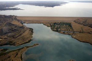
. At 21026 feet (6,408.7 m) in length and over 250 feet (76.2 m) in height, it is the largest hydraulically filled
Hydraulic fill
A hydraulic fill is an embankment or other fill in which the materials are deposited in place by a flowing stream of water, with the deposition being selective...
dam in the United States
United States
The United States of America is a federal constitutional republic comprising fifty states and a federal district...
, and creates Fort Peck Lake
Fort Peck Lake
Fort Peck Lake, or Lake Fort Peck, is a major reservoir in Montana, formed by the Fort Peck Dam on the Missouri River. The lake lies in the eastern prairie region of Montana approximately east of Great Falls and north of Billings, reaching into portions of six counties.The dam and reservoir were...
, the fifth largest man-made lake in the U.S., more than 130 miles (209.2 km) long, 200 feet (61 m) deep, and it has a 1520 miles (2,446.2 km) shoreline which is longer than the state of California's coastline. It lies within the Charles M. Russell National Wildlife Refuge
Charles M. Russell National Wildlife Refuge
Charles M. Russell National Wildlife Refuge surrounds Fort Peck Reservoir and at 1,100,000 acres is the largest refuge in Montana, United States. Created in 1936, the refuge was named after famed painter of the American West, Charles M. Russell...
. The dam and 134-mile (216 km) long lake exist for the purposes of hydroelectric power generation, flood control, and water quality management.
The dam presently has a nameplate capacity
Nameplate capacity
Nameplate capacity, also known as the rated capacity, nominal capacity, installed capacity or maximum effect, refers to the intended technical full–load sustained output of a facility such as a power plant, a chemical plant, fuel plant, metal refinery, mine, and many others.For dispatchable power,...
of 185.25 megawatts, divided among 5 generating units. Three units in powerhouse number one, completed in 1951, have a capacity of 105 MW. Completed in 1961, the two remaining generating units in powerhouse number 2, have a nameplate capacity of 80 MW.
The lake has a maximum operating pool elevation of 2250 feet (686 m) above mean sea level and a normal operating pool elevation of 2246 feet (684.6 m) above mean sea level. The lake level fluctuates over time based on a number of factors. During the first week of February 2007, the reservoir set a record low elevation of 2197 feet (669.6 m) above mean sea level, nearly 12 feet (3.7 m) lower than the previous record low set in 1991. In June 2011, in response to the 2011 Missouri River Floods
2011 Missouri River floods
The 2011 Missouri River floods are a flooding event on the Missouri River in the United States. The flooding has been triggered by record snowfall in the Rocky Mountains of Montana and Wyoming along with near record spring rainfall in central and eastern Montana...
, the dam was releasing almost 66000 cuft/s, which greatly exceeded its previous record release of 35000 cuft/s set in 1975.
Background
_spillway_01.jpg)
Public Works Administration
The Public Works Administration , part of the New Deal of 1933, was a large-scale public works construction agency in the United States headed by Secretary of the Interior Harold L. Ickes. It was created by the National Industrial Recovery Act in June 1933 in response to the Great Depression...
, part of the New Deal
New Deal
The New Deal was a series of economic programs implemented in the United States between 1933 and 1936. They were passed by the U.S. Congress during the first term of President Franklin D. Roosevelt. The programs were Roosevelt's responses to the Great Depression, and focused on what historians call...
. Construction of Fort Peck Dam started in 1933, and at its peak in July 1936 employed 10,546 workers. The dam, named for a 19th-century trading post, was completed in 1940, and began generating electricity in July 1943. The town of Fort Peck, Montana
Fort Peck, Montana
Fort Peck is a town in Valley County, Montana, United States. The population was 240 at the 2000 census.-History:The name Fort Peck is associated with Col. Campbell K. Peck, the partner of Elias H. Durfee in the Leavenworth, Kansas, trading firm of Durfee and Peck...
, "the government town," was built for Army Corps of Engineers personnel and men in "positions of responsibility" and their families during the dam's construction. Many of the facilities that supported the dam's workers are still utilized today, such as the recreation center and the theater. In addition to Fort Peck, other towns sprang up to house the workers. Among these were Wheeler and McCone City as well as more than a dozen others. Many of the homes were later moved to farms and towns around Montana.
Construction
The site chosen was on a stretch of the Missouri River flowing from south to north. The river bed at the site consisted of approximately 160 feet (48.8 m) of alluvial depositsAlluvium
Alluvium is loose, unconsolidated soil or sediments, eroded, deposited, and reshaped by water in some form in a non-marine setting. Alluvium is typically made up of a variety of materials, including fine particles of silt and clay and larger particles of sand and gravel...
, varying from coarse, pervious sand
Sand
Sand is a naturally occurring granular material composed of finely divided rock and mineral particles.The composition of sand is highly variable, depending on the local rock sources and conditions, but the most common constituent of sand in inland continental settings and non-tropical coastal...
s and gravel
Gravel
Gravel is composed of unconsolidated rock fragments that have a general particle size range and include size classes from granule- to boulder-sized fragments. Gravel can be sub-categorized into granule and cobble...
s to impermeable clay
Clay
Clay is a general term including many combinations of one or more clay minerals with traces of metal oxides and organic matter. Geologic clay deposits are mostly composed of phyllosilicate minerals containing variable amounts of water trapped in the mineral structure.- Formation :Clay minerals...
s. Beneath these deposits lay a thick (approximately 1000 feet (304.8 m)) deposit of Bear Paw shale
Shale
Shale is a fine-grained, clastic sedimentary rock composed of mud that is a mix of flakes of clay minerals and tiny fragments of other minerals, especially quartz and calcite. The ratio of clay to other minerals is variable. Shale is characterized by breaks along thin laminae or parallel layering...
. This shale is classified as a firm shale and contains thin (<1 to 6 in (2.5 to 15.2 cm) layers of bentonite
Bentonite
Bentonite is an absorbent aluminium phyllosilicate, essentially impure clay consisting mostly of montmorillonite. There are different types of bentonite, each named after the respective dominant element, such as potassium , sodium , calcium , and aluminum . Experts debate a number of nomenclatorial...
. The topmost layer of soft clay was removed from the alluvium in order to found the dam on the stable sandy deposits beneath, at an elevation of approximately 2050 feet (624.8 m). The remaining deposits consisted of the alluvial materials mentioned above. These deposits had many interconnecting layers of coarse sands and gravels, necessitating the installation of a steel
Steel
Steel is an alloy that consists mostly of iron and has a carbon content between 0.2% and 2.1% by weight, depending on the grade. Carbon is the most common alloying material for iron, but various other alloying elements are used, such as manganese, chromium, vanadium, and tungsten...
sheet pile wall down to the firm shale, from the left to the right abutment
Abutment
An abutment is, generally, the point where two structures or objects meet. This word comes from the verb abut, which means adjoin or having common boundary. An abutment is an engineering term that describes a structure located at the ends of a bridge, where the bridge slab adjoins the approaching...
.
The dam was planned to extend to an elevation of 2275 feet (693.4 m), for a total height of 225 feet (68.6 m) from the cleared river bed and had a length from the left to the right abutment of approximately 10500 feet (3,200.4 m). The upstream face was designed with an average slope of one vertical on four horizontal and included three horizontal shelves built into the slope. A flatter (1 on 7.5) berm
Berm
A berm is a level space, shelf, or raised barrier separating two areas. Berm originates in the Middle Dutch and German berme and came into usage in English via French.- History :...
was to be placed between stations 30+00 and 75+00 (approximately the center half of the length of the dam).
Since the construction method of hydraulic fill
Hydraulic fill
A hydraulic fill is an embankment or other fill in which the materials are deposited in place by a flowing stream of water, with the deposition being selective...
was chosen, four electric dredges needed to be built. Due to the distance of the site from the nearest shoreline, a shipyard was started on the site, affectionately dubbed “The Fort Peck Navy” and “The Biggest Shipyard in Montana” by the workers. These dredges would pump material from nearby borrow pit
Borrow pit
A borrow pit, also known as a sand box, is a term used in construction and civil engineering. It describes an area where material has been dug for use at another location. Borrow pits can be found close to many major construction projects...
s to the dam site where it was discharged by pipes along the outside edges of the fill. The coarser material settled out quickly, while the fines were carried downhill toward what would eventually become the core of the dam. Samples were take from all zones regularly to ensure that the material had the gradation and consolidation
Consolidation (geology)
Consolidation is a process by which soils decrease in volume. According to Karl Terzaghi "consolidation is any process which involves decrease in water content of a saturated soil without replacement of water by air." In general it is the process in which reduction in volume takes place by...
characteristics specified by the design.
Dam failure during construction
This process proceeded until elevation of the fill reached approximately 2250 ft (686 metres (2,250.7 ft) (61 m) above the foundation), while the reservoir was at an elevation of 2117.5 feet (645.4 m). At this point, the danger of the core pool overtopping or bursting the shell became greater because the beaches became narrower. For this reason, an extensive alarm system was implemented along the narrower upstream shell. This alarm system could immediately shut off the dredge pumps if a shell breach was detected. Part of this alarm system involved monitoring the elevations of the core pool and the pipelines carrying the dredged fill.On the morning of September 22, 1938, an inspection by the engineer in charge of construction revealed that the elevation of the pipeline relative to the core pool near station 15+10 (see attached overhead photo) was only 2.5 foot (0.762 m) when it should have been 4.5 feet (1.4 m). A survey crew was dispatched immediately to determine if the fill on which the pipeline was founded was settling or if the pipeline footing itself was settling. Preliminary measurement showed that the pipeline was closer to the pool than expected from station 15+00 to station 17+00. A meeting with the district engineer
Engineer
An engineer is a professional practitioner of engineering, concerned with applying scientific knowledge, mathematics and ingenuity to develop solutions for technical problems. Engineers design materials, structures, machines and systems while considering the limitations imposed by practicality,...
and supervisory personnel was scheduled for 1:15 p.m. near the location in question.
At approximately 1:15 p.m. the core pool near station 15+00 began to settle slowly. As its rate of settlement increased, cracks appeared 30 feet (9.1 m) below the crest in the upstream embankment. As the settlement of the pool got larger, portions of the shell began to slide backwards into the core pool area and the majority of the upstream shell began to move into the reservoir, translating
Translation (geometry)
In Euclidean geometry, a translation moves every point a constant distance in a specified direction. A translation can be described as a rigid motion, other rigid motions include rotations and reflections. A translation can also be interpreted as the addition of a constant vector to every point, or...
south and rotating slightly about the east abutment. The west end of the slide mass broke away from the dam near station 27+00 and the core pool water rapidly poured out of the breach that was created in the shell. Portions of the core in the still-stable portion of the dam continued to slump into the hole created by the loss of the slide mass. One construction supervisor was backing his car away from the advancing scarp
Escarpment
An escarpment is a steep slope or long cliff that occurs from erosion or faulting and separates two relatively level areas of differing elevations.-Description and variants:...
to the west along the beach to avoid the slumping and noted that the small scarp in the core was advancing to the west at a speed equal to his own (approximately 10 mph (16 km/h)).
A pump barge
Barge
A barge is a flat-bottomed boat, built mainly for river and canal transport of heavy goods. Some barges are not self-propelled and need to be towed by tugboats or pushed by towboats...
moored near the dam at the east abutment was swamped by the slide and was lost along with several tractors, loadmasters, and draglines on the slope. Of the 134 men working in the area at the time, 34 were carried into the sliding material. Of these 34, eight were unable to be rescued and lost their lives. Of these 8 men, only 2 bodies were ever recovered, leaving 6 men permanently entombed in the structure.
In the testing and analysis done by the Corps of Engineers
United States Army Corps of Engineers
The United States Army Corps of Engineers is a federal agency and a major Army command made up of some 38,000 civilian and military personnel, making it the world's largest public engineering, design and construction management agency...
and others to determine the cause of the slide, several modes of failure
Failure mode
Failure causes are defects in design, process, quality, or part application, which are the underlying cause of a failure or which initiate a process which leads to failure. Where failure depends on the user of the product or process, then human error must be considered.-Component failure:A part...
were considered. These were: movement along a weak zone in the shale in the abutment, movement along the shale surface, bursting of the shell due to excessive core pressure
Pressure
Pressure is the force per unit area applied in a direction perpendicular to the surface of an object. Gauge pressure is the pressure relative to the local atmospheric or ambient pressure.- Definition :...
, and temporary liquefaction
Soil liquefaction
Soil liquefaction describes a phenomenon whereby a saturated soil substantially loses strength and stiffness in response to an applied stress, usually earthquake shaking or other sudden change in stress condition, causing it to behave like a liquid....
of the shell or foundation sand. Extensive laboratory testing of the shale, both weathered and unweathered indicated strengths leading to a factor of safety greater than one. Also, portions of the weathered shale were found in the slide mass, indicating that the slip surface was located somewhere in the shale, but probably at a shallow depth. The core material turned out to be much stronger than expected (having a friction angle
Direct Shear Test
A direct shear test also known as shearbox test is a laboratory or field test used by geotechnical engineers to measure the shear strength properties of soil or rock material, or of discontinuties in soil or rock masses.- Soil :...
of approximately 29 degrees) and was carried out into the slide nearly in a solid mass, making it unlikely that the core was the weak point in the slide. Laboratory testing was done on the shell material and the foundation sand and it was determined that both materials were denser than the critical state for liquefaction. There was no evidence of ground vibration, seismic or otherwise. Some liquefaction may have occurred after the sliding was initiated, but it was unlikely that it caused the slide.
The major weak point in the dam seemed to be the bentonite seams in the Bear Paw shale. Very high water pressures were reported at some points in the shale during the construction. This was likely caused by consolidation due to the overburden of the fill being placed for the dam. The excess pore pressures
Pore water pressure
Pore water pressure refers to the pressure of groundwater held within a soil or rock, in gaps between particles . Pore water pressures in below the phreatic level are measured in piezometers...
could not be relieved due to the low permeability
Permeability (fluid)
Permeability in fluid mechanics and the earth sciences is a measure of the ability of a porous material to allow fluids to pass through it.- Units :...
of the surrounding shale. This resulted in a low effective stress
Shear stress
A shear stress, denoted \tau\, , is defined as the component of stress coplanar with a material cross section. Shear stress arises from the force vector component parallel to the cross section...
in the bentonite and a very low shear strength
Shear strength (soil)
Shear strength is a term used in soil mechanics to describe the magnitude of the shear stress that a soil can sustain. The shear resistance of soil is a result of friction and interlocking of particles, and possibly cementation or bonding at particle contacts. Due to interlocking, particulate...
.
Representations in art and literature
Fort Peck Dam is probably best known for being the subject of a photograph of the spillway taken by Margaret Bourke-WhiteMargaret Bourke-White
Margaret Bourke-White was an American photographer and documentary photographer. She is best known as the first foreign photographer permitted to take pictures of Soviet Industry, the first female war correspondent and the first female photographer for Henry Luce's Life magazine, where her...
while still under construction that was the cover photo of the first issue of Life magazine
Life (magazine)
Life generally refers to three American magazines:*A humor and general interest magazine published from 1883 to 1936. Time founder Henry Luce bought the magazine in 1936 solely so that he could acquire the rights to its name....
on November 23, 1936. Later, the photograph by Bourke-White was used on a United States postage stamp in the "Celebrate the Century" series.
The dam is also center-stage in Bucking the Sun, by the Montana-born writer Ivan Doig
Ivan Doig
Ivan Doig is an American novelist. He was born in White Sulphur Springs, Montana to a family of homesteaders and ranch hands. After the death of his mother Berneta, on his sixth birthday, he was raised by his father Charles "Charlie" Doig and his grandmother Elizabeth "Bessie" Ringer...
, published in 1996. The novel tells the story of the fictional Duff family and their various roles in the mammoth dam project, and in the process describes the working conditions and way of life of the thousands of workers hired to construct the Fort Peck Dam, many of them homesteaders from upriver farms destined to disappear under the waters of the newly formed Fort Peck Lake.
Fifty Cents an Hour: The Builders and Boomtowns of the Fort Peck Dam, by Montana author Lois Lonnquist, published in 2006, is an overall history of the Fort Peck dam and spillway construction. Built by the Army Corps of Engineers, PWA Project #30 provided thousands of jobs during the Great Depression. The book includes the history of the boomtowns that sprang up in the area, and the "project people" who lived and worked at Fort Peck during the "d am days."
M. R. Montgomery, Personal History, "Impalpable Dust," The New Yorker, March 27, 1989, p. 94 was written by the son of an engineer who worked at the dam during its construction. After his father's death, the author researched the dam's construction and his father's role in it.
Further reading
- Doig, IvanIvan DoigIvan Doig is an American novelist. He was born in White Sulphur Springs, Montana to a family of homesteaders and ranch hands. After the death of his mother Berneta, on his sixth birthday, he was raised by his father Charles "Charlie" Doig and his grandmother Elizabeth "Bessie" Ringer...
(1996) Bucking the Sun, New York: Simon and Schuster, Inc. ISBN 0-684-81171-5
- Lonnquist, Lois (2006) Fifty Cents an Hour: The Builders and Boomtowns of the Fort Peck Dam, MtSky Press ISBN 0-9786963-0-1
External links
- Fort Peck Project website - U.S. Army Corps of Engineers
- Fort Peck Dam, unofficial website
- Life Magazine construction photos