
Fatra-Tatra Area
Encyclopedia
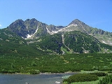
The Fatra-Tatra Area or the Tatra-Fatra Belt of core mountains (in the geology) is a part of the Inner Western Carpathians, a subprovince of the Western Carpathians
. Most of the area lies in Slovakia
with small parts reaching into Austria
and Poland
. The highest summit of the whole Carpathians, the Gerlachovský štít at , lies in the High Tatras
range which belongs to this area.
The Fatra-Tatra Area is from the northern side bounded by Pieniny Klippen Belt
. Mountains of the area are located in two ranges. The external range consists of Hainburg Hills, Malé Karpaty (Pezinok part), Považský Inovec
, Strážovské vrchy, Malá Fatra, Tatras (Western
, High
and Belianske Tatry). Inner range consists of Tribeč
, Žiar
, Veľká Fatra, Chočské vrchy, Ďumbier part of Nízke Tatry and massif of Smrekovica
in the Branisko
. The southern boundary of Area is the Čertovica line, south of which is the Vepor Belt.
The Tatra-Fatra Belt consists of Tatric alpine crystalline basement
and its autochthonous sedimentary cover, over which the Subtatric nappes (Fatric and Hronic) were thrust.
Name core mountains is derived from structural element, resistant crystalline basement rocks
, preserved in the core of horsts, often forming the highest peaks
of the mountains.
and igneous rocks and locally also a sedimentary cover of various thickness. In the Paleozoic
clastic and volcanoclastic sediments deposited in the area, but later during Hercynian orogeny, sediments were metamorphosed in the greenschist
and amphibolite facies (forming large amount of paragneisses and amphibolite
s, only locally orthogneisses, phyllite
s and mica schists). Regional and contact metamorphism was induced also by intrusion
s of granite
s, which accompanied the Hercynian collision (generally in the Carboniferous
). Basement rocks were later exposed due to erosion
and at the end of the Paleozoic affected by marine transgression
that lasted till the end of Mesozoic
. During this period sedimentary rocks, known as Tatric cover units, deposited. They generally consists of clastic and carbonate rock
s.
 In the Upper Cretaceous area of Tatric Unit, was affected by Eo-Alpine of Alpine Orogeny
, that caused movement of large masses of rocks to the North and Northeast. To the South of the Tatric area a 2 superficial nappe
s, so called Subtatric Nappes, were detached and thrust over the Tatric. These nappes are generally composed of limestone
, marl
, dolostone
and less by sandstone
s and slate
s. The lower nappes is called Krížna Nappe (or the Fatric) and the upper is Choč Nappe (or the Hronic). Krížňa Nappe is composed of rock, that were formed in the basin called Fatric. It was situated in the area between the Tatric and Veporic units. Fatric had the same basement as the Veporic unit and is considered as former northern part of Veporic, but later during the thrusting its substratum was consumed and subducted. Surface occurrences of Fatric basement remained only as a remnants in the northern part of Veporic Veľký Bok Unit and few other areas. Choč Nappe, was thrust from the southern area, but its roots were probably consumed entirely, so its paleogeographic position is not exactly known. Choč Nappe is considered as rootless nappe.
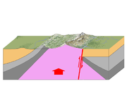
After the end of main Eo-Alpine orogenic movement, the area of Western Carpathians was still not so mountainous. In the Paleogene
subsidence along the normal faults caused formation of graben
s - intra-mountain Inner Carpathian Paleogene Basin and horsts present day mountain ranges. In the Neogene, further orogene movement in the external part of Carpathian arc caused formation of back-arc
Pannonian Basin
. Northern branches of Pannonian Basin were penetrating the Tatra-Fatra Area and formed inter-mountain basins. Simultaneously with the immersion of the horsts, ongoing and intense erosion is denuding the mountains and supplies the basin with clastic sediments. Among all of the rocks, the most erosion resistant were the crystalline schists and granites of the Tatric. Similar fold and thrust model of origin is known from the other areas of alpine system. In the English
terminology, similar model is called Fault-block mountain
, it is typical in the area of Basin and Range
.
Western Carpathians
The Western Carpathians are a mountain range and geomorphological province that forms the western part of the Carpathian Mountains.The mountain belt stretches from the Low Beskids range of the Eastern Carpathians along the border of Poland with Slovakia toward the Moravian region of the Czech...
. Most of the area lies in Slovakia
Slovakia
The Slovak Republic is a landlocked state in Central Europe. It has a population of over five million and an area of about . Slovakia is bordered by the Czech Republic and Austria to the west, Poland to the north, Ukraine to the east and Hungary to the south...
with small parts reaching into Austria
Austria
Austria , officially the Republic of Austria , is a landlocked country of roughly 8.4 million people in Central Europe. It is bordered by the Czech Republic and Germany to the north, Slovakia and Hungary to the east, Slovenia and Italy to the south, and Switzerland and Liechtenstein to the...
and Poland
Poland
Poland , officially the Republic of Poland , is a country in Central Europe bordered by Germany to the west; the Czech Republic and Slovakia to the south; Ukraine, Belarus and Lithuania to the east; and the Baltic Sea and Kaliningrad Oblast, a Russian exclave, to the north...
. The highest summit of the whole Carpathians, the Gerlachovský štít at , lies in the High Tatras
High Tatras
High Tatras or High Tatra are a mountain range on the borders between Slovakia and Poland. They are a part of the Tatra Mountains...
range which belongs to this area.
The Fatra-Tatra Area is from the northern side bounded by Pieniny Klippen Belt
Pieniny Klippen Belt
The Pieniny Klippen Belt is in geology a tectonically and orographically remarkable zone in the Western Carpathians, with a very complex geological structure...
. Mountains of the area are located in two ranges. The external range consists of Hainburg Hills, Malé Karpaty (Pezinok part), Považský Inovec
Považský Inovec
Považský Inovec is a mountain range in western Slovakia, named after the Váh river. It is 48 km long and 15-25 km wide mountain range...
, Strážovské vrchy, Malá Fatra, Tatras (Western
Western Tatras
The Western Tatras are mountains in the Tatras, part of the Carpathian Mountains, located on the Polish-Slovak borders. The mountains border the High Tatras in the east, Podtatranská kotlina in the south, Choč Mountains in the west and Rów Podtatrzański in the north...
, High
High Tatras
High Tatras or High Tatra are a mountain range on the borders between Slovakia and Poland. They are a part of the Tatra Mountains...
and Belianske Tatry). Inner range consists of Tribeč
Tribec
Tribeč is a crystalline mountain range in western Slovakia, in the Inner Western Carpathians within the Fatra-Tatra Area, roughly between the towns of Nitra, Partizánske and Zlaté Moravce. It is surrounded by the Danubian Lowland, Pohronský Inovec, Vtáčnik mountains and the Upper Nitra Basin. It is...
, Žiar
Žiar (mountain range)
Žiar is a mountain range in the Trenčín Region of northwestern Slovakia, part of the ranges of the Fatra-Tatra Area of the Inner Western Carpathians....
, Veľká Fatra, Chočské vrchy, Ďumbier part of Nízke Tatry and massif of Smrekovica
Smrekovica
Smrekovica is a village in the municipality of Breza, Bosnia and Herzegovina.-References:...
in the Branisko
Branisko (mountain range)
Branisko is a mountain range in eastern Slovakia, between the Spiš and Šariš regions. It is a 20 km long and 5 km wide mountain range in the north-south direction, belonging to the Fatra-Tatra Area of the Inner Western Carpathians....
. The southern boundary of Area is the Čertovica line, south of which is the Vepor Belt.
The Tatra-Fatra Belt consists of Tatric alpine crystalline basement
Basement (geology)
In geology, the terms basement and crystalline basement are used to define the rocks below a sedimentary platform or cover, or more generally any rock below sedimentary rocks or sedimentary basins that are metamorphic or igneous in origin...
and its autochthonous sedimentary cover, over which the Subtatric nappes (Fatric and Hronic) were thrust.
Name core mountains is derived from structural element, resistant crystalline basement rocks
Basement (geology)
In geology, the terms basement and crystalline basement are used to define the rocks below a sedimentary platform or cover, or more generally any rock below sedimentary rocks or sedimentary basins that are metamorphic or igneous in origin...
, preserved in the core of horsts, often forming the highest peaks
Summit (topography)
In topography, a summit is a point on a surface that is higher in elevation than all points immediately adjacent to it. Mathematically, a summit is a local maximum in elevation...
of the mountains.
Origin
The basement of the core mountains is formed by the Tatric Unit, which is composed of dominantly hercynian metamorphicMetamorphic rock
Metamorphic rock is the transformation of an existing rock type, the protolith, in a process called metamorphism, which means "change in form". The protolith is subjected to heat and pressure causing profound physical and/or chemical change...
and igneous rocks and locally also a sedimentary cover of various thickness. In the Paleozoic
Paleozoic
The Paleozoic era is the earliest of three geologic eras of the Phanerozoic eon, spanning from roughly...
clastic and volcanoclastic sediments deposited in the area, but later during Hercynian orogeny, sediments were metamorphosed in the greenschist
Greenschist
Greenschist is a general field petrologic term applied to metamorphic or altered mafic volcanic rock. The term greenstone is sometimes used to refer to greenschist but can refer to other rock types too. The green is due to abundant green chlorite, actinolite and epidote minerals that dominate the...
and amphibolite facies (forming large amount of paragneisses and amphibolite
Amphibolite
Amphibolite is the name given to a rock consisting mainly of hornblende amphibole, the use of the term being restricted, however, to metamorphic rocks. The modern terminology for a holocrystalline plutonic igneous rocks composed primarily of hornblende amphibole is a hornblendite, which are...
s, only locally orthogneisses, phyllite
Phyllite
Phyllite is a type of foliated metamorphic rock primarily composed of quartz, sericite mica, and chlorite; the rock represents a gradation in the degree of metamorphism between slate and mica schist. Minute crystals of graphite, sericite, or chlorite impart a silky, sometimes golden sheen to the...
s and mica schists). Regional and contact metamorphism was induced also by intrusion
Intrusion
An intrusion is liquid rock that forms under Earth's surface. Magma from under the surface is slowly pushed up from deep within the earth into any cracks or spaces it can find, sometimes pushing existing country rock out of the way, a process that can take millions of years. As the rock slowly...
s of granite
Granite
Granite is a common and widely occurring type of intrusive, felsic, igneous rock. Granite usually has a medium- to coarse-grained texture. Occasionally some individual crystals are larger than the groundmass, in which case the texture is known as porphyritic. A granitic rock with a porphyritic...
s, which accompanied the Hercynian collision (generally in the Carboniferous
Carboniferous
The Carboniferous is a geologic period and system that extends from the end of the Devonian Period, about 359.2 ± 2.5 Mya , to the beginning of the Permian Period, about 299.0 ± 0.8 Mya . The name is derived from the Latin word for coal, carbo. Carboniferous means "coal-bearing"...
). Basement rocks were later exposed due to erosion
Erosion
Erosion is when materials are removed from the surface and changed into something else. It only works by hydraulic actions and transport of solids in the natural environment, and leads to the deposition of these materials elsewhere...
and at the end of the Paleozoic affected by marine transgression
Transgression (geology)
A marine transgression is a geologic event during which sea level rises relative to the land and the shoreline moves toward higher ground, resulting in flooding. Transgressions can be caused either by the land sinking or the ocean basins filling with water...
that lasted till the end of Mesozoic
Mesozoic
The Mesozoic era is an interval of geological time from about 250 million years ago to about 65 million years ago. It is often referred to as the age of reptiles because reptiles, namely dinosaurs, were the dominant terrestrial and marine vertebrates of the time...
. During this period sedimentary rocks, known as Tatric cover units, deposited. They generally consists of clastic and carbonate rock
Carbonate rock
Carbonate rocks are a class of sedimentary rocks composed primarily of carbonate minerals. The two major types are limestone, which is composed of calcite or aragonite and dolostone, which is composed of the mineral dolomite .Calcite can be either dissolved by groundwater or precipitated by...
s.
Alpine orogeny
The Alpine orogeny is an orogenic phase in the Late Mesozoic and Tertiary that formed the mountain ranges of the Alpide belt...
, that caused movement of large masses of rocks to the North and Northeast. To the South of the Tatric area a 2 superficial nappe
Nappe
In geology, a nappe is a large sheetlike body of rock that has been moved more than or 5 km from its original position. Nappes form during continental plate collisions, when folds are sheared so much that they fold back over on themselves and break apart. The resulting structure is a...
s, so called Subtatric Nappes, were detached and thrust over the Tatric. These nappes are generally composed of limestone
Limestone
Limestone is a sedimentary rock composed largely of the minerals calcite and aragonite, which are different crystal forms of calcium carbonate . Many limestones are composed from skeletal fragments of marine organisms such as coral or foraminifera....
, marl
Marl
Marl or marlstone is a calcium carbonate or lime-rich mud or mudstone which contains variable amounts of clays and aragonite. Marl was originally an old term loosely applied to a variety of materials, most of which occur as loose, earthy deposits consisting chiefly of an intimate mixture of clay...
, dolostone
Dolostone
Dolostone or dolomite rock is a sedimentary carbonate rock that contains a high percentage of the mineral dolomite. In old U.S.G.S. publications it was referred to as magnesian limestone. Most dolostone formed as a magnesium replacement of limestone or lime mud prior to lithification. It is...
and less by sandstone
Sandstone
Sandstone is a sedimentary rock composed mainly of sand-sized minerals or rock grains.Most sandstone is composed of quartz and/or feldspar because these are the most common minerals in the Earth's crust. Like sand, sandstone may be any colour, but the most common colours are tan, brown, yellow,...
s and slate
Slate
Slate is a fine-grained, foliated, homogeneous metamorphic rock derived from an original shale-type sedimentary rock composed of clay or volcanic ash through low-grade regional metamorphism. The result is a foliated rock in which the foliation may not correspond to the original sedimentary layering...
s. The lower nappes is called Krížna Nappe (or the Fatric) and the upper is Choč Nappe (or the Hronic). Krížňa Nappe is composed of rock, that were formed in the basin called Fatric. It was situated in the area between the Tatric and Veporic units. Fatric had the same basement as the Veporic unit and is considered as former northern part of Veporic, but later during the thrusting its substratum was consumed and subducted. Surface occurrences of Fatric basement remained only as a remnants in the northern part of Veporic Veľký Bok Unit and few other areas. Choč Nappe, was thrust from the southern area, but its roots were probably consumed entirely, so its paleogeographic position is not exactly known. Choč Nappe is considered as rootless nappe.
After the end of main Eo-Alpine orogenic movement, the area of Western Carpathians was still not so mountainous. In the Paleogene
Paleogene
The Paleogene is a geologic period and system that began 65.5 ± 0.3 and ended 23.03 ± 0.05 million years ago and comprises the first part of the Cenozoic Era...
subsidence along the normal faults caused formation of graben
Graben
In geology, a graben is a depressed block of land bordered by parallel faults. Graben is German for ditch. Graben is used for both the singular and plural....
s - intra-mountain Inner Carpathian Paleogene Basin and horsts present day mountain ranges. In the Neogene, further orogene movement in the external part of Carpathian arc caused formation of back-arc
Back-arc basin
Back-arc basins are geologic features, submarine basins associated with island arcs and subduction zones.They are found at some convergent plate boundaries, presently concentrated in the Western Pacific ocean. Most of them result from tensional forces caused by oceanic trench rollback and the...
Pannonian Basin
Pannonian Basin
The Pannonian Basin or Carpathian Basin is a large basin in East-Central Europe.The geomorphological term Pannonian Plain is more widely used for roughly the same region though with a somewhat different sense - meaning only the lowlands, the plain that remained when the Pliocene Pannonian Sea dried...
. Northern branches of Pannonian Basin were penetrating the Tatra-Fatra Area and formed inter-mountain basins. Simultaneously with the immersion of the horsts, ongoing and intense erosion is denuding the mountains and supplies the basin with clastic sediments. Among all of the rocks, the most erosion resistant were the crystalline schists and granites of the Tatric. Similar fold and thrust model of origin is known from the other areas of alpine system. In the English
English language
English is a West Germanic language that arose in the Anglo-Saxon kingdoms of England and spread into what was to become south-east Scotland under the influence of the Anglian medieval kingdom of Northumbria...
terminology, similar model is called Fault-block mountain
Fault-block mountain
Fault-block landforms are formed when large areas of bedrock are widely broken up by faults creating large vertical displacements of continental crust....
, it is typical in the area of Basin and Range
Basin and Range
The Basin and Range Province is a vast physiographic region defined by a unique topographic expression. Basin and Range topography is characterized by abrupt changes in elevation, alternating between narrow faulted mountain chains and flat arid valleys or basins...
.