
Western Tatras
Encyclopedia
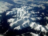
The Western Tatras are mountains in the Tatras, part of the Carpathian Mountains
Carpathian Mountains
The Carpathian Mountains or Carpathians are a range of mountains forming an arc roughly long across Central and Eastern Europe, making them the second-longest mountain range in Europe...
, located on the Polish
Poland
Poland , officially the Republic of Poland , is a country in Central Europe bordered by Germany to the west; the Czech Republic and Slovakia to the south; Ukraine, Belarus and Lithuania to the east; and the Baltic Sea and Kaliningrad Oblast, a Russian exclave, to the north...
-Slovak
Slovakia
The Slovak Republic is a landlocked state in Central Europe. It has a population of over five million and an area of about . Slovakia is bordered by the Czech Republic and Austria to the west, Poland to the north, Ukraine to the east and Hungary to the south...
borders. The mountains border the High Tatras
High Tatras
High Tatras or High Tatra are a mountain range on the borders between Slovakia and Poland. They are a part of the Tatra Mountains...
in the east, Podtatranská kotlina
Podtatranská kotlina
The Podtatranská kotlina is a basin in northern Slovakia, part of the Fatra-Tatra Area, which belongs to the Inner Western Carpathians....
in the south, Choč Mountains
Choč Mountains
The Choč Mountains are a range of mountains in north-central Slovakia, a portion of the Fatra-Tatra Area of the Inner Western Carpathians. The range is 24 kilometers long and on average only 4 kilometers wide...
in the west and Rów Podtatrzański in the north. The main ridge is 37 kilometers long and the mountain range contains 31 two-thousander
Two-thousander
Two-thousanders are mountains that have a height of at least 2,000 metres above sea level, but less than 3,000 metres.The two photographs show two typical two-thousanders in the Alps that illustrate different types of mountain...
s.
Western Tatras are the second highest mountain range in Slovakia; its highest peak is Bystrá at 2,248 meters. Other notable mountains include Jakubiná (2,194 m), Baranec (2,184 m), Baníkov
Baníkov
Baníkov is a mountain in the Western Tatras mountain range, Slovakia. It reaches a height of 2,178 meters, being the highest point of the main ridge of Western Tatras....
(2,178 m), Tri kopy (2,136.3 m), Plačlivé (2,125.1 m), Ostrý Roháč (2,087.5 m), Volovec (Polish: Wołowiec; 2,064 m), Kasprowy Wierch (Slovak: Kasprov vrch; 1,987 m) and Giewont
Giewont
Giewont is a mountain massif in the Tatra Mountains of Poland, and is 1895 metres AMSL at its highest.It comprises three peaks :* Small Giewont -...
(1,894 m). In Slovakia, they are partially located in the traditional regions of Liptov
Liptov
Liptó is the name of a historic administrative county of the Kingdom of Hungary. Its territory is presently in northern Slovakia.-Geography:...
and Orava
Orava
Orava may refer to:*Orava , a region in Slovakia and Poland*Orava in Slovakia*Orava , a castle in Slovakia*Orava , a reservoir in Slovakia...
. The highest point in Poland is Starorobociański Wierch (2,176 m).
All visitors to the Western Tatras area are obliged since July 1, 2006 to cover all costs of their rescue by the Mountain Rescue Service
Mountain Rescue Service (Slovakia)
The Mountain Rescue Service of Slovakia provides nation-wide Mountain Rescue operations and Search and Rescue operations in difficult terrains in close cooperations with the Air Rescue Service...
. Visitors are prohibited from leaving the marked tourist routes, sleeping
Bivouac shelter
A bivouac traditionally refers to a military encampment made with tents or improvised shelters, usually without shelter or protection from enemy fire or such a site where a camp may be built. It is also commonly used to describe a variety of improvised camp sites such as those used in scouting and...
in the mountains or setting fire
Campfire
A campfire is a fire lit at a campsite, to serve the following functions: light, warmth, a beacon, a bug and/or apex predator deterrent, to cook, and for a psychological sense of security. In established campgrounds they are usually in a fire ring for safety. Campfires are a popular feature of...
are strictly prohibited.
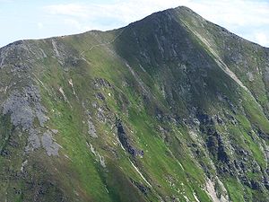
Division
The Western Tatras are subdivided into 6 regions on the Slovak side and 4 on the Polish side.Slovak Western Tatras:
- Osobitá (highest point: Osobitá, 1 687 m)
- Sivý vrch (highest point: Sivý vrch, 1 805 m)
- Liptovské Tatry (highest point: BystráBystrá (mountain)Bystrá is the highest mountain in the Western Tatras in Slovakia, near the Polish border. It is 2,248 meters high and surrounded by the valleys of Kamenistá, Račkova and Bystrá.-References:*...
, 2 248 m) - Roháče (highest point: BaníkovBaníkovBaníkov is a mountain in the Western Tatras mountain range, Slovakia. It reaches a height of 2,178 meters, being the highest point of the main ridge of Western Tatras....
, 2 178 m) - Červené vrchy (highest point: Kresanica / Krzesanica, 2 122 m)
- Liptovské kopy (highest point: Veľká kopa, 2 122 m)
Polish Western Tatras:
- Grześ
- Kasprowy Wierch
- Czerwone Wierchy (corresponds to Červené vrchy, highest point: Kresanica / Krzesanica, 2 122 m)
- Ornak
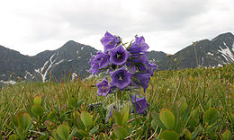
Geology and ecology
The Western Tatras are protected by Tatranský národný park in Slovakia and Tatrzański Park Narodowy in Poland.Peaks
The following is a list of the highest 10 of the 31 two-thousanders in Western Tatras:| Image | Slovak name | Polish name | Height | Location & Notes |
|---|---|---|---|---|
 | Bystrá Bystrá (mountain) Bystrá is the highest mountain in the Western Tatras in Slovakia, near the Polish border. It is 2,248 meters high and surrounded by the valleys of Kamenistá, Račkova and Bystrá.-References:*... | Bystra | 2 248,4 m | Liptovské Tatry, the highest peak in Slovak Western Tatras |
| Jakubiná | Raczkowa Czuba | 2 193,7 m | ||
| Baranec | Baraniec | 2 184,6 m | ||
| Baníkov Baníkov Baníkov is a mountain in the Western Tatras mountain range, Slovakia. It reaches a height of 2,178 meters, being the highest point of the main ridge of Western Tatras.... | Banówka | 2 178 m | Highest point on the main ridge | |
| Klin Klin (mountain) Klin is a peak in the Western Tatras, on the border between Slovakia and Poland. Its summit is at 2,176 m AMSL. It is the highest peak in Polish Western Tatras.... | Starorobociański Wierch | 2 176 m | Main ridge, the highest peak in Polish Western Tatras | |
| Pachoľa | Pachola | 2 167 m | Main ridge | |
| Hrubá kopa | Hruba Kopa | 2 166 m | Main ridge | |
| Blyšť | Błyszcz | 2 159 m | Bystrá ridge | |
| Príslop | Jałowiecki Przysłop | 2 142 m | ||
| Hrubý vrch | Jarząbczy Wierch | 2 137 m |
Saddles (cols)
- Pálenica (1 570 m)
- Parichvost (1 870 m)
- Baníkovské sedlo (2 045 m)
- Smutné sedlo (1 965 m)
- Žiarske sedlo (1 917,1 m)
- Jamnícke sedlo (1 908 m)
- Račkovo sedlo (1 958 m)
- Gáborovo sedlo (1 890 m)
- Bystré sedlo (1 960 m)
- Pyšné sedlo (1 791,6 m)
- Tomanovské sedlo (1 685,9 m)
- Ľaliové sedlo (1 951,8 m)
Tarns
There are approximately 20 to 32 tarnsTarn (lake)
A tarn is a mountain lake or pool, formed in a cirque excavated by a glacier. A moraine may form a natural dam below a tarn. A corrie may be called a cirque.The word is derived from the Old Norse word tjörn meaning pond...
in Western Tatras. The exact number is difficult to obtain because of lack of an exact definition and because it is sometimes hard to prove what is a tarn and what is not. The following is a list of 15 largest tarns in Western Tatras:
| Image | Slovak name | Polish name | Height (m Meters above sea level Meters above sea Level is a standard metric measurement of the elevation of a location in reference to historic mean sea level; the determination of what actually constitutes mean sea level over time however, may be determined by other parameters, such as the effects of climate history and climate... ) | Area (ha Hectare The hectare is a metric unit of area defined as 10,000 square metres , and primarily used in the measurement of land. In 1795, when the metric system was introduced, the are was defined as being 100 square metres and the hectare was thus 100 ares or 1/100 km2... ) | Depth (m) |
|---|---|---|---|---|---|
| Dolné Roháčske pleso | Niżni Staw Rohacki | 1 563 | 2,22 | 6,3 | |
| Horné Roháčske pleso | Wyżni Staw Rohacki | 1 718 | 1,45 | 8,1 | |
| Dolné Jamnícke pleso | Niżni Jamnicki Staw | 1 728 | 1,13 | 4,0 | |
| Horné Bystré pleso | Wielki Staw Bystry | 1 875 | 0,86 | 12,5 | |
| Horné Račkovo pleso | Zadni Staw Raczkowy | 1 717 | 0,74 | 10,0 | |
| Tretie Roháčske pleso | Pośredni Rohacki Staw | 1 653 | 0,61 | 3,7 | |
| Horné Jamnícke pleso | Wyżni Jamnicki Staw | 1 834 | 0,41 | 8,0 | |
| Spodné Bystré pleso | Niżni Staw Bystry | 1 837 | 0,34 | 4,0 | |
| Pleso pod Zverovkou | Stawek pod Zwierówką | 983 | 0,31 | 1,2 | |
| Ťatliakovo pleso | Czarna Młaka | 1 370 | 0,28 | 1,2 | |
| Druhé Roháčske pleso | Mały Rohacki Staw | 1 650 | 0,28 | 1,3 | |
| Horné Tomanovo pleso | Wyżni Tomanowy Stawek | 1 592 | 0,19 | 1,0 | |
| Žiarske pleso | 1 860 | 0,11 | 0,8 | ||
| Kobylie pleso | Kobyli Stawek | 1 742 | 0,10 | 1,5 | |
| Biele Bobrovecké pleso | Biały Stawek Bobrowiecki | 1 502 | 0,10 | 1,5 |
Caves
- Jaskinia Wielka ŚnieżnaJaskinia Wielka SnieznaJaskinia Wielka Śnieżna is a limestone cave in mount Małołączniak in the Western Tatras. With the length of 23.619 km and vertical range of 824 m, it is the largest and deepest cave of Poland.- Morphology :...
, the largest and deepest cave in Poland - Brestovská cave, uniquely features an underground river (not accessible to the public)
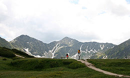
Tourism
There are four tourist centers inside the Western Tatras area: Zverovka, Brestová and Ťatliakova chata in the northern region and Žiarska chata in the southern region. All other tourist centers lie at the outside borders of the mountains, including: OraviceOravice
Oravice may refer to the following places:* Oravița, a town in southwestern Romania* Oravice , a town in northern Slovakia...
, Zuberec
Zuberec
Zuberec is a village in northern Slovakia and a popular tourist center at the foothills of the Western Tatras. Zuberec features numerous accommodation facilities, restaurants, museum and a tourist information office....
, Bobrovecká vápenica, Žiar
Žiar, Liptovský Mikuláš District
Žiar is a village and municipality in Liptovský Mikuláš District in the Žilina Region of northern Slovakia.-Geography:The municipality lies at an altitude of 765 metres and covers an area of 21.894 km²...
, Konská
Konská, Liptovský Mikuláš District
Konská is a village and municipality in Liptovský Mikuláš District in the Žilina Region of northern Slovakia.-Geography:The municipality lies at an altitude of 745 metres and covers an area of 1.1806 km2. It has a population of about 241 people....
, Jakubovany
Jakubovany, Liptovský Mikuláš District
Jakubovany is a village and municipality in Liptovský Mikuláš District in the Žilina Region of northern Slovakia.-Geography:The municipality lies at an altitude of 715 metres and covers an area of 9.109km². It has a population of about 430 people....
-Studená dolina, Pribylina
Pribylina
Pribylina is a village in Liptovský Mikuláš District in the Žilina Region of northern Slovakia, at the foot of Kriváň, Slovakia's symbolic and often considered most beautiful mountain.-Geography:...
, Podbanské.
See also
- Eastern TatrasEastern TatrasThe Eastern Tatras form part of the European Tatra Mountains range in Poland and Slovakia.The Eastern Tatras consist of the High Tatras and the Belianske Tatras ranges.-See also:*Western Tatras*Tatra National Park, Slovakia*Tatra National Park, Poland...
– mountain range bordering the Western Tatras in the east - Mountain Rescue Service (Slovakia)Mountain Rescue Service (Slovakia)The Mountain Rescue Service of Slovakia provides nation-wide Mountain Rescue operations and Search and Rescue operations in difficult terrains in close cooperations with the Air Rescue Service...
- Tourism in SlovakiaTourism in SlovakiaTourism in Slovakia offers natural landscapes, mountains, caves, medieval castles and towns, folk architecture, spas and ski resorts.More than 1.6 million people visited Slovakia in 2006, and the most attractive destinations are the capital of Bratislava and the High Tatras...
Sources
- Touristic map 1:25000 Západné Tatry - Podbanské - Zverovka, VKÚ a.s. Harmanec, 2008