

Pieniny Klippen Belt
Encyclopedia
Geology
Geology is the science comprising the study of solid Earth, the rocks of which it is composed, and the processes by which it evolves. Geology gives insight into the history of the Earth, as it provides the primary evidence for plate tectonics, the evolutionary history of life, and past climates...
a tectonically
Tectonics
Tectonics is a field of study within geology concerned generally with the structures within the lithosphere of the Earth and particularly with the forces and movements that have operated in a region to create these structures.Tectonics is concerned with the orogenies and tectonic development of...
and orographically
Orography
Orography is the study of the formation and relief of mountains, and can more broadly include hills, and any part of a region's elevated terrain...
remarkable zone in the Western Carpathians
Western Carpathians
The Western Carpathians are a mountain range and geomorphological province that forms the western part of the Carpathian Mountains.The mountain belt stretches from the Low Beskids range of the Eastern Carpathians along the border of Poland with Slovakia toward the Moravian region of the Czech...
, with a very complex geological structure. It is a narrow (only 0.4 to 19 km) and extremely long (about 600 km) north banded zone of extreme shortening and sub-vertical strike-slip fault zone, resulting from subduction
Subduction
In geology, subduction is the process that takes place at convergent boundaries by which one tectonic plate moves under another tectonic plate, sinking into the Earth's mantle, as the plates converge. These 3D regions of mantle downwellings are known as "Subduction Zones"...
of the Piemont-Liguria Ocean
Piemont-Liguria Ocean
The Piemont-Liguria basin or the Piemont-Liguria Ocean was a former piece of oceanic crust that is seen as part of the Tethys Ocean...
(which is called the Vahic or Pieninic ocean in the Western Carpathians), where only fragments of individual strata
Stratum
In geology and related fields, a stratum is a layer of sedimentary rock or soil with internally consistent characteristics that distinguish it from other layers...
and facies
Facies
In geology, facies are a body of rock with specified characteristics. Ideally, a facies is a distinctive rock unit that forms under certain conditions of sedimentation, reflecting a particular process or environment....
are preserved. The Pieniny Klippen Belt is considered one of the main tectonic suture
Suture (geology)
In structural geology, a suture is a major fault zone through an orogen or mountain range. Sutures separate terranes, tectonic units that have different plate tectonic, metamorphic and paleogeographic histories...
s of the Carpathians and forms the boundary between the Outer (externides a thin-skin thrustbelt) and Central Western Carpathians (internal thick-skin thrustbelt).
The Pieniny Klippen Belt emerges from beneath the Neogene
Neogene
The Neogene is a geologic period and system in the International Commission on Stratigraphy Geologic Timescale starting 23.03 ± 0.05 million years ago and ending 2.588 million years ago...
sediments of the Vienna basin
Vienna Basin
The Vienna Basin is a sedimentary basin between the Alps and the Carpathian Mountains...
near Podbranč
Podbranc
Podbranč is a village and municipality in Senica District in the Trnava Region of western Slovakia.-Geography:The municipality lies at an altitude of 420 metres and covers an area of 14.137km². It has a population of about 645 people....
in western Slovakia
Slovakia
The Slovak Republic is a landlocked state in Central Europe. It has a population of over five million and an area of about . Slovakia is bordered by the Czech Republic and Austria to the west, Poland to the north, Ukraine to the east and Hungary to the south...
and continues eastward to Poland
Poland
Poland , officially the Republic of Poland , is a country in Central Europe bordered by Germany to the west; the Czech Republic and Slovakia to the south; Ukraine, Belarus and Lithuania to the east; and the Baltic Sea and Kaliningrad Oblast, a Russian exclave, to the north...
, where it bends and returns to Slovakia in the area of Pieniny
Pieniny
Pieniny is a mountain range in the south of Poland and the north of Slovakia.The Pieniny mountain range is divided into three parts – Pieniny Spiskie and Pieniny Właściwe in Poland; and, Malé Pieniny in Slovakia. The Pieniny mountains consist mainly of the limestone and dolomite rock strata...
. The klippen belt then continues to Ukraine
Ukraine
Ukraine is a country in Eastern Europe. It has an area of 603,628 km², making it the second largest contiguous country on the European continent, after Russia...
and ends in Romania
Romania
Romania is a country located at the crossroads of Central and Southeastern Europe, on the Lower Danube, within and outside the Carpathian arch, bordering on the Black Sea...
. In some places it is covered with younger deposits, for example in the Podhale basin in Poland, or in the Vihorlat Mountains
Vihorlat Mountains
Vihorlat Mountains or colloquially Vihorlat is a volcanic mountain range in eastern Slovakia and western Ukraine. A part of the range is listed as a World Heritage Site.-Vihorlat Mountains in Slovakia:...
in Slovakia.
Klippe
Klippe
thumb|right|350px|Schematic overview of a thrust system. The shaded material is called a [[nappe]]. The erosional hole is called a [[window |window or fenster]]. The klippe is the isolated block of the nappe overlying autochthonous material....
s, which are the most characteristic features of the belt, are Jurassic
Jurassic
The Jurassic is a geologic period and system that extends from about Mya to Mya, that is, from the end of the Triassic to the beginning of the Cretaceous. The Jurassic constitutes the middle period of the Mesozoic era, also known as the age of reptiles. The start of the period is marked by...
to lower Cretaceous
Cretaceous
The Cretaceous , derived from the Latin "creta" , usually abbreviated K for its German translation Kreide , is a geologic period and system from circa to million years ago. In the geologic timescale, the Cretaceous follows the Jurassic period and is followed by the Paleogene period of the...
lenses
Lens (geology)
In geology a lens is a body of ore or rock or a deposit that is thick in the middle and thin at the edges, resembling a convex lens in cross-section. Adjective: "lenticular"....
- rigid blocks of limestone
Limestone
Limestone is a sedimentary rock composed largely of the minerals calcite and aragonite, which are different crystal forms of calcium carbonate . Many limestones are composed from skeletal fragments of marine organisms such as coral or foraminifera....
, tectonically separated from their unknown substratum. These blocks are also cropping out in tectonic windows
Window (geology)
thumb|right|350px|Schematic overview of a thrust system. The [[fault |hanging wall block]] is called a [[nappe]]. If an [[erosion]]al hole is created in the nappe that is called a window. A [[klippe]] is a solitary outcrop of the nappe in the middle of autochthonous material.A tectonic window...
in the overlying middle Cretaceous to Paleogene
Paleogene
The Paleogene is a geologic period and system that began 65.5 ± 0.3 and ended 23.03 ± 0.05 million years ago and comprises the first part of the Cenozoic Era...
sediments. Strong tectonic deformation is a result of two main phases during the Alpine orogeny
Alpine orogeny
The Alpine orogeny is an orogenic phase in the Late Mesozoic and Tertiary that formed the mountain ranges of the Alpide belt...
. The oldest phase is called the Laramide phase or Jarmuta phase and occurred in the Cretaceous and Paleogene periods. It caused thrusting
Thrust fault
A thrust fault is a type of fault, or break in the Earth's crust across which there has been relative movement, in which rocks of lower stratigraphic position are pushed up and over higher strata. They are often recognized because they place older rocks above younger...
of the nappes. The second phase is called the Savian or Helvetian phase. It was induced by subduction of the Northern Penninic ocean
Valais Ocean
The Valais Ocean is a disappeared piece of oceanic crust which was situated between the continent Europe and the microcontinent Iberia or so called Briançonnais microcontinent...
and caused the formation of the Carpathian Flysch Belt.
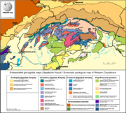
Geological structure
The Pieniny Klippen Belt is divided into numerous tectonic units, but only few of them occur throughout the entire belt. The oldest rocks of the Klippen belt are Middle JurassicMiddle Jurassic
The Middle Jurassic is the second epoch of the Jurassic Period. It lasted from 176-161 million years ago. In European lithostratigraphy, rocks of this Middle Jurassic age are called the Dogger....
to upper Cretaceous
Cretaceous
The Cretaceous , derived from the Latin "creta" , usually abbreviated K for its German translation Kreide , is a geologic period and system from circa to million years ago. In the geologic timescale, the Cretaceous follows the Jurassic period and is followed by the Paleogene period of the...
. They are in normal stratigraphical positions, with only minor hiatus. Large scale crustal shortening caused rocks of different tectonic units and origin to be thrusted over each other and now lying juxtaposed. These tectonic units are:
- The Czorsztyn unit, named after Czorstyn in Poland, is found in the most northern part of the Klippen Belt. It consists of shallow marine sediments, usually Jurassic nodular limestones and Cretaceous so called couches rouges marlstones.
- The Kysuca unit (also known as Kysuca-Pieniny unit). The Jurassic sediments of this unit are mostly deep marine in origin (typical radiolariteRadiolariteRadiolarite is a siliceous, comparatively hard, fine-grained, chert-like, and homogeneous sedimentary rock that is composed predominantly of the microscopic remains of radiolarians. This term is also used for indurated radiolarian oozes and sometimes as a synonym of radiolarian earth...
s). Most of the other tectonic units were deposited between the shallow Czorsztyn and deep marine Kysuca unit. - the Pruske unit (also known as the Niedzice or Czertezice unit) has a transitional facies between shallow and deep marine environments.
- The Klape unit composed of cretaceous turbiditic sediments containing exotic conglomerateConglomerate (geology)A conglomerate is a rock consisting of individual clasts within a finer-grained matrix that have become cemented together. Conglomerates are sedimentary rocks consisting of rounded fragments and are thus differentiated from breccias, which consist of angular clasts...
s with pebbles from an unknown source area. It is probably an acretionary wedge or some unknown terraneTerraneA terrane in geology is short-hand term for a tectonostratigraphic terrane, which is a fragment of crustal material formed on, or broken off from, one tectonic plate and accreted or "sutured" to crust lying on another plate...
carried by the Fatric, but its origin is still a subject of discussion. - Orava unit with typical limestones with unique ammoniteAmmoniteAmmonite, as a zoological or paleontological term, refers to any member of the Ammonoidea an extinct subclass within the Molluscan class Cephalopoda which are more closely related to living coleoids Ammonite, as a zoological or paleontological term, refers to any member of the Ammonoidea an extinct...
fauna, typical klippes occur only in OravaOrava (region)Orava is the traditional name of a region situated in northern Slovakia and partially also in southern Poland . It encompasses the territory of the former Árva county.-History:...
region. - The Manín unit contains typical Urgonian limestone. It has only partially a tectonic style of klippes, It is usually assigned to the Fatricum as well as the Drietoma and Haligovce units. Its origin is still disputed, because some geologists consider it a proximal part of the Tatric sedimentary cover.
The Czorsztyn unit has the shallowest marine facies. Together with smaller continental slope units and the deep marine Kysuca unit it forms a continental domain called the Oravicum, which is geometrically equivalent to the Briançonnais microcontinent
Briançonnais microcontinent
The Briançonnais zone or Briançonnais terrane is a piece of continental crust found in the Penninic nappes of the Alps.According to some paleogeographic reconstructions the rocks of the Briançonnais zone were in fact a part of the microcontinent Iberia, that encompassed not only the Iberian...
in the Western and Central Alps.
Development
Reconstruction of the older phases of development is not possible because of absence of pre-triassicTriassic
The Triassic is a geologic period and system that extends from about 250 to 200 Mya . As the first period of the Mesozoic Era, the Triassic follows the Permian and is followed by the Jurassic. Both the start and end of the Triassic are marked by major extinction events...
rocks. The development of Pieniny Klippen Belt started on passive margin
Passive margin
A passive margin is the transition between oceanic and continental crust which is not an active plate margin. It is constructed by sedimentation above an ancient rift, now marked by transitional crust. Continental rifting creates new ocean basins. Eventually the continental rift forms a mid-oceanic...
of European platform in Lower Jurassic with rifting and tectonic subsidence
Subsidence
Subsidence is the motion of a surface as it shifts downward relative to a datum such as sea-level. The opposite of subsidence is uplift, which results in an increase in elevation...
of Oravic unit. During the Middle Jurassic
Middle Jurassic
The Middle Jurassic is the second epoch of the Jurassic Period. It lasted from 176-161 million years ago. In European lithostratigraphy, rocks of this Middle Jurassic age are called the Dogger....
to Lowermost Cretaceous
Cretaceous
The Cretaceous , derived from the Latin "creta" , usually abbreviated K for its German translation Kreide , is a geologic period and system from circa to million years ago. In the geologic timescale, the Cretaceous follows the Jurassic period and is followed by the Paleogene period of the...
an elevated continental ribbon called the Czorsztyn Ridge evolved due to the thermal uplift and continental break-up at the southern side of the Czorsztyn Ridge. Rifting resulted in the opening of basinal area called the Kysuca basin or Vahic Ocean (South Penninic or Piemont ocean
Piemont-Liguria Ocean
The Piemont-Liguria basin or the Piemont-Liguria Ocean was a former piece of oceanic crust that is seen as part of the Tethys Ocean...
equivalent) to the south of the Oravic area. In the Upper Jurassic entire Oravic domain began to thermally subside. Since Lowermost Cretaceous time probably an asymmetrical rifting affected the area to the North of the Czorsztyn Ridge where a Magura basin (North Penninic or Valais Ocean
Valais Ocean
The Valais Ocean is a disappeared piece of oceanic crust which was situated between the continent Europe and the microcontinent Iberia or so called Briançonnais microcontinent...
equivalent) started to evolve.
During the Middle Cretaceous thermal subsidence
Thermal subsidence
In geology and geophysics, thermal subsidence is a mechanism of subsidence in which conductive cooling of the mantle thickens the lithosphere and causes it to decrease in elevation. This is because of thermal contraction: as mantle material cools and becomes part of the mechanically-rigid...
of the Czorsztyn Ridge caused it development into a pelagic high. In Turonian
Turonian
The Turonian is, in the ICS' geologic timescale, the second age in the Late Cretaceous epoch, or a stage in the Upper Cretaceous series. It spans the time between 93.5 ± 0.8 Ma and 89.3 ± 1 Ma...
times frontal elements of the Fatric Nappe System of the Inner Western Carpathians were emplaced onto the southern parts of the Vahic Ocean. In the Upper Cretaceous to Paleocene
Paleocene
The Paleocene or Palaeocene, the "early recent", is a geologic epoch that lasted from about . It is the first epoch of the Palaeogene Period in the modern Cenozoic Era...
the Vahic Ocean began to close. The Oravic units were detached from its subducting basement and formed a fold and thrust belt. After first phase of folding and thrusting sedimentation of turbiditic
Turbidite
Turbidite geological formations have their origins in turbidity current deposits, which are deposits from a form of underwater avalanche that are responsible for distributing vast amounts of clastic sediment into the deep ocean.-The ideal turbidite sequence:...
sequences was restored. Whole area was again deformed in second phase of orogeny in the Upper Paleogene to Lower Miocene when sinistral transpression and amalgamation with hinterland part of closed Magura Ocean caused formation of typical "klippen" tectonic style due to counterclockwise rotation of ALCAPA microplate. During this times several subduction related calc-alcaline volcano
Volcano
2. Bedrock3. Conduit 4. Base5. Sill6. Dike7. Layers of ash emitted by the volcano8. Flank| 9. Layers of lava emitted by the volcano10. Throat11. Parasitic cone12. Lava flow13. Vent14. Crater15...
es locally evolved in the area. Later sinistral transtension and lateral extension modified the structure of the belt during the Late Miocene
Late Miocene
The Late Miocene is a sub-epoch of the Miocene Epoch made up of two stages. The Tortonian and Messinian stages comprise the Late Miocene sub-epoch....
and Pliocene
Pliocene
The Pliocene Epoch is the period in the geologic timescale that extends from 5.332 million to 2.588 million years before present. It is the second and youngest epoch of the Neogene Period in the Cenozoic Era. The Pliocene follows the Miocene Epoch and is followed by the Pleistocene Epoch...
. Extensional deformation on the eastern and western edge of the belt interacted with development of the Vienna
Vienna Basin
The Vienna Basin is a sedimentary basin between the Alps and the Carpathian Mountains...
and Transcarpathian basin. After the marine regression at the end of Miocene younger marl
Marl
Marl or marlstone is a calcium carbonate or lime-rich mud or mudstone which contains variable amounts of clays and aragonite. Marl was originally an old term loosely applied to a variety of materials, most of which occur as loose, earthy deposits consisting chiefly of an intimate mixture of clay...
s and turbidites were eroded faster than more competent Jurassic limestones forming distinctly looking klippes.