

European route E70
Encyclopedia
European route E 70 is an A-Class West-East European route, extending from A Coruña
in Spain
in the west to the Georgian
city of Poti
in the east.
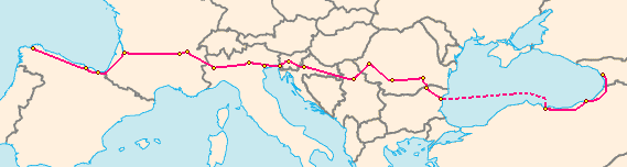
in Bulgaria
to Samsun
in Turkey
.
The E 70 takes a roundabout route through northern Spain, due to some sections of the A-8 being incomplete. Its length is approximately 686 km or 426 mi
The E 70 crosses approximately 989 km or 610 mi across southern France
The E 70 crosses approximately 650 km or 403 mi
The E 70 passes through approximately 186 km or 115 mi of central Slovenia
The E 70 passes through approximately 306 km (190.1 mi) in Croatia. Starting eastbound at the Bregana
border crossing, it follows the western part of the A3 highway
to Zagreb
, where it reaches the Zagreb bypass
at the Jankomir interchange. At the Ivanja Reka interchange
E70 again follows A3 going eastbound. It passes control cities Slavonski Brod
and Županja
before it reaches the Serbia
n border at Lipovac.
The E 70 passes through approximately 205 km or 126 mi of Serbia
The E 70 passes through approximately 695 km or 431 miles
Between Giurgiu
and Rousse
E 70 crosses Danube
river on Danube Bridge.
The E 70 passes through approximately 186 km or 115 mi of northern Bulgaria
Then it is supposed to cross the Black Sea by ferry to Samsun
, Turkey
, but there is still no shipping line
which runs such a connection.
From Samsun, the E 70 follows the Black Sea
coast through Ordu
and Trabzon
before entering Georgia
[ს 2] Sarpi, Batumi
, Kobuleti
, Poti
A Coruña
A Coruña or La Coruña is a city and municipality of Galicia, Spain. It is the second-largest city in the autonomous community and seventeenth overall in the country...
in Spain
Spain
Spain , officially the Kingdom of Spain languages]] under the European Charter for Regional or Minority Languages. In each of these, Spain's official name is as follows:;;;;;;), is a country and member state of the European Union located in southwestern Europe on the Iberian Peninsula...
in the west to the Georgian
Georgia (country)
Georgia is a sovereign state in the Caucasus region of Eurasia. Located at the crossroads of Western Asia and Eastern Europe, it is bounded to the west by the Black Sea, to the north by Russia, to the southwest by Turkey, to the south by Armenia, and to the southeast by Azerbaijan. The capital of...
city of Poti
Poti
Poti is a port city in Georgia, located on the eastern Black Sea coast in the region of Samegrelo-Zemo Svaneti in the west of the country. Built near the site of the ancient Greek colony of Phasis, the city has become a major port city and industrial center since the early 20th century. It is also...
in the east.
Itinerary
The E 70 routes through ten European countries, and includes one sea-crossing, from VarnaVarna
Varna is the largest city and seaside resort on the Bulgarian Black Sea Coast and third-largest in Bulgaria after Sofia and Plovdiv, with a population of 334,870 inhabitants according to Census 2011...
in Bulgaria
Bulgaria
Bulgaria , officially the Republic of Bulgaria , is a parliamentary democracy within a unitary constitutional republic in Southeast Europe. The country borders Romania to the north, Serbia and Macedonia to the west, Greece and Turkey to the south, as well as the Black Sea to the east...
to Samsun
Samsun
Samsun is a city of about half a million people on the north coast of Turkey. It is the provincial capital of Samsun Province and a major Black Sea port.-Name:...
in Turkey
Turkey
Turkey , known officially as the Republic of Turkey , is a Eurasian country located in Western Asia and in East Thrace in Southeastern Europe...
.
The E 70 takes a roundabout route through northern Spain, due to some sections of the A-8 being incomplete. Its length is approximately 686 km or 426 mi
- Autovía A-6Autovía A-6The Autovía A-6 or Autopista AP-6 is a Spanish autovía and autopista route which starts in Madrid and ends in Arteixo ....
: A CoruñaA CoruñaA Coruña or La Coruña is a city and municipality of Galicia, Spain. It is the second-largest city in the autonomous community and seventeenth overall in the country...
- Baamonde (73 km/45 mi) - N-634: Baamonde - Canero (146 km/91 mi)
- N-632: Canero - AvilésAvilésAvilés is a city in Asturias, Spain. Avilés is with Oviedo and Gijón, one of the main towns in the Principality of Asturias.The town occupies the flattest land in the municipality, in a land that belonged to the sea, surrounded by small promontories, all of them having an altitude of less than...
(61 km/38 mi) - Autovía A-8Autovía A-8The Autovía A-8 is a highway that connects all the regions on the Northern Coast of Spain. It is known as the Autovía del Cantábrico and connects Baamonde and Bilbao, where it continues as the Autopista AP-8 to the French border...
: Avilés - SerínSerínSerín is a district of the municipality of Gijón / Xixón, in Asturias, Spain.The population of Serín was 309 in 2004Serín is located on the western area of Gijón / Xixón, and borders the Asturian municipalities of Llanera, Corvera and Carreño.Barrios & Places:-External links:* - Gijón / Xixón...
(10 km/6 mi) - Autovía A-8Autovía A-8The Autovía A-8 is a highway that connects all the regions on the Northern Coast of Spain. It is known as the Autovía del Cantábrico and connects Baamonde and Bilbao, where it continues as the Autopista AP-8 to the French border...
/ Autovía A-66Autovía A-66The Autovía A-66 is a major highway in western Spain. It also forms part of the European Route E803. The road is an upgrade of the N-630 which is being undertaken section by section. The route roughly corresponds to the ancient Roman 'Silver Route' from the mines of northern Spain to the...
: Serin - GijónGijónGijón , officially Gijón / Xixón, is a coastal industrial city and a municipality in the autonomous community of Asturias in Spain. Early mediaeval texts mention it as "Gigia". It was an important regional Roman city, although the area has been settled since earliest history...
(13 km/8 mi) - Autovía A-8Autovía A-8The Autovía A-8 is a highway that connects all the regions on the Northern Coast of Spain. It is known as the Autovía del Cantábrico and connects Baamonde and Bilbao, where it continues as the Autopista AP-8 to the French border...
: GijónGijónGijón , officially Gijón / Xixón, is a coastal industrial city and a municipality in the autonomous community of Asturias in Spain. Early mediaeval texts mention it as "Gigia". It was an important regional Roman city, although the area has been settled since earliest history...
- TorrelavegaTorrelavegaTorrelavega is a municipality and important industrial and commercial hub in the single province Autonomous Community of Cantabria in northern Spain....
(152 km/95 mi) - N-634: Torrelavega - (near SantanderSantander, CantabriaThe port city of Santander is the capital of the autonomous community and historical region of Cantabria situated on the north coast of Spain. Located east of Gijón and west of Bilbao, the city has a population of 183,446 .-History:...
) - Valdecilla (22 km/14 mi) - Autovía A-8/Autopista AP-8Autovía A-8The Autovía A-8 is a highway that connects all the regions on the Northern Coast of Spain. It is known as the Autovía del Cantábrico and connects Baamonde and Bilbao, where it continues as the Autopista AP-8 to the French border...
: Valdecilla - BilbaoBilbaoBilbao ) is a Spanish municipality, capital of the province of Biscay, in the autonomous community of the Basque Country. With a population of 353,187 , it is the largest city of its autonomous community and the tenth largest in Spain...
- Donostia-San Sebastián - IrúnIrunIrun is a town of the Bidasoa-Txingudi region in the province of Gipuzkoa in the Basque Autonomous Community, Spain...
- FranceFranceThe French Republic , The French Republic , The French Republic , (commonly known as France , is a unitary semi-presidential republic in Western Europe with several overseas territories and islands located on other continents and in the Indian, Pacific, and Atlantic oceans. Metropolitan France...
(201 km/125 mi)
The E 70 crosses approximately 989 km or 610 mi across southern France
- A-63A63 autorouteThe A63 autoroute is a motorway in southwest France. It is made up of two sections; the northern one is toll-free, connecting Bordeaux with Belin-Béliet. The southern section is operated by ASF and links Bordeaux to the border with Spain...
/N-10: Spain - BiarritzBiarritzBiarritz is a city which lies on the Bay of Biscay, on the Atlantic coast, in south-western France. It is a luxurious seaside town and is popular with tourists and surfers....
- BayonneBayonneBayonne is a city and commune in south-western France at the confluence of the Nive and Adour rivers, in the Pyrénées-Atlantiques department, of which it is a sub-prefecture...
- BordeauxBordeauxBordeaux is a port city on the Garonne River in the Gironde department in southwestern France.The Bordeaux-Arcachon-Libourne metropolitan area, has a population of 1,010,000 and constitutes the sixth-largest urban area in France. It is the capital of the Aquitaine region, as well as the prefecture...
(216 km/134 mi) - N-89/A-89A89 autorouteThe A89 autoroute is a motorway in central France. It is known as the La Transeuropéenne. It will connect Lyon with Bordeaux.-Completed Sections:* Antenne de Balbigny* Combronde-Saint-Julien-Puy-Lavèze-Ussel-Tulle-Saint-Germain-les-Vergnes...
: Bordeaux - Brive-la-GaillardeBrive-la-GaillardeBrive-la-Gaillarde is a commune of France. It is a sub-prefecture of the Corrèze department. The population of the urban area was 89,260 as of 1999. Although it is by far the biggest commune in Corrèze, the capital is Tulle.-History:...
- Clermont-FerrandClermont-FerrandClermont-Ferrand is a city and commune of France, in the Auvergne region, with a population of 140,700 . Its metropolitan area had 409,558 inhabitants at the 1999 census. It is the prefecture of the Puy-de-Dôme department...
(373 km/231 mi) - A-72A72 autorouteThe A72 is an autoroute in France.The motorway is operated by Autoroutes du Sud de la France and links Clermont-Ferrand to Saint-Étienne on one of the steepest and meandrous motorways in France...
: Clermont-Ferrand - Saint-EtienneSaint-ÉtienneSaint-Étienne is a city in eastern central France. It is located in the Massif Central, southwest of Lyon in the Rhône-Alpes region, along the trunk road that connects Toulouse with Lyon...
(139 km/86 mi) - A-47A47 autorouteThe A47 autoroute is a highway in central France. Completed in 1983 it connects Givors to Saint-Étienne. It also serves the suburbs south-west of Lyon and east of Saint-Étienne.-History:...
: Saint-Etienne - LyonLyonLyon , is a city in east-central France in the Rhône-Alpes region, situated between Paris and Marseille. Lyon is located at from Paris, from Marseille, from Geneva, from Turin, and from Barcelona. The residents of the city are called Lyonnais....
(58 km/36 mi) - A-43A43 autorouteThe A43 autoroute is a motorway in eastern France. Travelling through the western Alps it is also known as the Autoroute alpine or Autoroute de la Maurienne. It connects Lyon with Saint-Jean-de-Maurienne and Modane to Italy and Turin. It is operated by AREA and SFTRF...
: Lyon - ChambéryChambéryChambéry is a city in the department of Savoie, located in the Rhône-Alpes region in southeastern France.It is the capital of the department and has been the historical capital of the Savoy region since the 13th century, when Amadeus V of Savoy made the city his seat of power.-Geography:Chambéry...
- Fréjus Road TunnelFréjus Road TunnelThe Fréjus Road Tunnel is a tunnel that connects France and Italy. It runs under Col du Fréjus in the Cottian Alps between Modane in France and Bardonecchia in Italy...
with ItalyItalyItaly , officially the Italian Republic languages]] under the European Charter for Regional or Minority Languages. In each of these, Italy's official name is as follows:;;;;;;;;), is a unitary parliamentary republic in South-Central Europe. To the north it borders France, Switzerland, Austria and...
(197 km/122 mi)
The E 70 crosses approximately 650 km or 403 mi
- A32: France - TurinTurinTurin is a city and major business and cultural centre in northern Italy, capital of the Piedmont region, located mainly on the left bank of the Po River and surrounded by the Alpine arch. The population of the city proper is 909,193 while the population of the urban area is estimated by Eurostat...
(100 km/62 mi) - A21: Turin - AlessandriaAlessandria-Monuments:* The Citadel * The church of Santa Maria di Castello * The church of Santa Maria del Carmine * Palazzo Ghilini * Università del Piemonte Orientale-Museums:* The Marengo Battle Museum...
- BresciaBresciaBrescia is a city and comune in the region of Lombardy in northern Italy. It is situated at the foot of the Alps, between the Mella and the Naviglio, with a population of around 197,000. It is the second largest city in Lombardy, after the capital, Milan...
(252 km/156 mi) - A4: Brescia - VeronaVeronaVerona ; German Bern, Dietrichsbern or Welschbern) is a city in the Veneto, northern Italy, with approx. 265,000 inhabitants and one of the seven chef-lieus of the region. It is the second largest city municipality in the region and the third of North-Eastern Italy. The metropolitan area of Verona...
- Padova - near VeniceVeniceVenice is a city in northern Italy which is renowned for the beauty of its setting, its architecture and its artworks. It is the capital of the Veneto region...
- TriesteTriesteTrieste is a city and seaport in northeastern Italy. It is situated towards the end of a narrow strip of land lying between the Adriatic Sea and Italy's border with Slovenia, which lies almost immediately south and east of the city...
- Fernetti (Slovenian border) (528 km/328 mi)
The E 70 passes through approximately 186 km or 115 mi of central Slovenia
- A3: Fernetiči (Italian border) - DivačaDivacaDivača is a small town and municipality in the Littoral region of Slovenia, a few kilometres from the Italian border.The Parish Church in the settlement is dedicated to Saint Anthony the Hermit and belongs to the Diocese of Koper....
: (12 km/7 mi) - A1A1 motorway (Slovenia)The A1 motorway is 236,1 km long, connecting Šentilj and Koper/Capodistria . It passes several important Slovenian cities, including Maribor, Celje and Ljubljana all the way to the Slovenian Littoral and Koper, with its important port.Construction began in 1970 and the first section was...
: Divača - LjubljanaLjubljanaLjubljana is the capital of Slovenia and its largest city. It is the centre of the City Municipality of Ljubljana. It is located in the centre of the country in the Ljubljana Basin, and is a mid-sized city of some 270,000 inhabitants...
: (67 km/41 mi) - A2A2 motorway (Slovenia)The A2 motorway is a motorway in Slovenia, around 175 km long, connecting Karavanke Tunnel via the capital city Ljubljana to Obrežje . It connects several larger Slovenian cities, including Kranj, Ljubljana and Novo Mesto, and is part of the Pan-European corridor X.The motorway was completed...
: Ljubljana - ObrežjeObrežjeObrežje is a settlement in the Brežice municipality in eastern Slovenia, close to the border with Croatia. A major motorway border crossing is located here. Obrežje is the end/start of Slovenia's A2 motorway. It connects to Croatia's A3 Motorway. Both motorways form part of the European route...
(Croatian border): (107 km/66 mi)
The E 70 passes through approximately 306 km (190.1 mi) in Croatia. Starting eastbound at the Bregana
Bregana
Bregana is a settlement in the Town of Samobor, Zagreb County, Croatia. According to the 2001 census, the town has 2,518 residents living in an area of . Together with the nearby settlements of Podvrh and Klokočevec Samoborski, the town's micropolitan area has 3,450 inhabitants.Together with...
border crossing, it follows the western part of the A3 highway
A3 (Croatia)
The A3 motorway is a major motorway in Croatia spanning . The motorway connects Zagreb, the nation's capital, to the Slavonia region and a number of cities along the Sava River. It represents a major east–west transportation corridor in Croatia and a significant part of the Pan-European Corridor...
to Zagreb
Zagreb
Zagreb is the capital and the largest city of the Republic of Croatia. It is in the northwest of the country, along the Sava river, at the southern slopes of the Medvednica mountain. Zagreb lies at an elevation of approximately above sea level. According to the last official census, Zagreb's city...
, where it reaches the Zagreb bypass
Zagreb bypass
Zagreb bypass , is an U-shaped motorway partially encircling Zagreb, Croatia. The largest part by far, between Jankomir and Ivanja Reka interchanges, has been built between 1977 and 1979, while Ivanja Reka - Sveta Helena section has been built between 1996 and 1999. The bypass is long, tracing...
at the Jankomir interchange. At the Ivanja Reka interchange
Ivanja Reka interchange
The Ivanja Reka interchange is a cloverleaf interchange east of Zagreb, Croatia. The interchange represents the southern terminus of the A4 motorway and it connects the A4 route to the A3 motorway representing major a link in the Croatian motorway system. The interchange is a part of Pan-European...
E70 again follows A3 going eastbound. It passes control cities Slavonski Brod
Slavonski Brod
Slavonski Brod is a city in Croatia, with a population of 59,507 in 2011. The city was known as Marsonia in the Roman Empire, and as Brod na Savi 1244–1934. It is the sixth largest city in Croatia, after Zagreb, Split, Rijeka, Osijek and Zadar. Located in the region of Slavonia, it is the...
and Županja
Županja
Županja is a city in eastern Slavonia, Croatia, located 254 km east of Zagreb. It is administratively part of the Vukovar-Syrmia county. It is inhabited by 12,185 people ....
before it reaches the Serbia
Serbia
Serbia , officially the Republic of Serbia , is a landlocked country located at the crossroads of Central and Southeast Europe, covering the southern part of the Carpathian basin and the central part of the Balkans...
n border at Lipovac.
The E 70 passes through approximately 205 km or 126 mi of Serbia
- Routes 1 and 4: Bajakovo - BelgradeBelgradeBelgrade is the capital and largest city of Serbia. It is located at the confluence of the Sava and Danube rivers, where the Pannonian Plain meets the Balkans. According to official results of Census 2011, the city has a population of 1,639,121. It is one of the 15 largest cities in Europe...
(114 km/70 mi) - Route 1.9: Belgrade - RomaniaRomaniaRomania is a country located at the crossroads of Central and Southeastern Europe, on the Lower Danube, within and outside the Carpathian arch, bordering on the Black Sea...
(91 km/56 mi)
The E 70 passes through approximately 695 km or 431 miles
- : Serbia - Stamora Moraviţa - TimişoaraTimisoaraTimișoara is the capital city of Timiș County, in western Romania. One of the largest Romanian cities, with an estimated population of 311,586 inhabitants , and considered the informal capital city of the historical region of Banat, Timișoara is the main social, economic and cultural center in the...
(62 km/38 mi) - DN6DN6Romania's DN6 links the capital city of Bucharest to the Banat region, in western Romania, and further to the eastern European capitals Budapest and Belgrade...
: Timişoara - Lugoj - CaransebeşCaransebesCaransebeş is a city in Caraş-Severin County, part of the Banat region in southwestern Romania. It is located at the confluence of the river Timiş with the river Sebeş, the latter coming from the Ţarcu Mountains. To the west, it is in direct contact with the Banat hills...
- OrşovaOrsovaOrșova is a port city on the Danube river in southwestern Romania's Mehedinți County. It is one of four localities in the county located in the Banat historical region. It is situated just above the Iron Gates, on the spot where the Cerna River meets the Danube.- History :The first documented...
- Drobeta-Turnu SeverinDrobeta-Turnu SeverinDrobeta-Turnu Severin is a city in Mehedinţi County, Oltenia, Romania, on the left bank of the Danube, below the Iron Gates.The city administers three villages: Dudaşu Schelei, Gura Văii, and Schela Cladovei...
(219 km/136 mi) - : Drobeta-Turnu Severin - FiliaşiFiliasiFiliaşi is a town in Dolj County, Romania, on the Jiu River. In 2002, it had a population of 18,848. The town administers six villages: Almăjel, Bâlta, Branişte, Fratoştiţa, Răcarii de Sus and Uscăci....
- CraiovaCraiovaCraiova , Romania's 6th largest city and capital of Dolj County, is situated near the east bank of the river Jiu in central Oltenia. It is a longstanding political center, and is located at approximately equal distances from the Southern Carpathians and the River Danube . Craiova is the chief...
(111 km/69 mi) - : Craiova - CaracalCaracalThe caracal is a fiercely territorial medium-sized cat ranging over Western Asia, South Asia and Africa.The word caracal comes from the Turkish word "karakulak", meaning "black ear". In North India and Pakistan, the caracal is locally known as syahgosh or shyahgosh, which is a Persian term...
- Roşiori de Vede - AlexandriaAlexandria, RomaniaAlexandria is the capital city of the Teleorman County, Romania. It is located south-west of Bucharest, towards the Bulgarian border. The city is situated on the Vedea River. The city has 58,651 inhabitants.-Alexandria in 1900:...
(136 km/85 mi) - : Alexandria - BucharestBucharestBucharest is the capital municipality, cultural, industrial, and financial centre of Romania. It is the largest city in Romania, located in the southeast of the country, at , and lies on the banks of the Dâmbovița River....
(89 km/55 mi) - DN5DN5DN5 is an important national road in Romania which links Bucharest with the southern country border with Bulgaria by the Giurgiu Russe Friendship Bridge....
: Bucharest - GiurgiuGiurgiuGiurgiu is the capital city of Giurgiu County, Romania, in the Greater Wallachia. It is situated amid mud-flats and marshes on the left bank of the Danube facing the Bulgarian city of Rousse on the opposite bank. Three small islands face the city, and a larger one shelters its port, Smarda...
- BulgariaBulgariaBulgaria , officially the Republic of Bulgaria , is a parliamentary democracy within a unitary constitutional republic in Southeast Europe. The country borders Romania to the north, Serbia and Macedonia to the west, Greece and Turkey to the south, as well as the Black Sea to the east...
(52 km/32 mi)
Between Giurgiu
Giurgiu
Giurgiu is the capital city of Giurgiu County, Romania, in the Greater Wallachia. It is situated amid mud-flats and marshes on the left bank of the Danube facing the Bulgarian city of Rousse on the opposite bank. Three small islands face the city, and a larger one shelters its port, Smarda...
and Rousse
Rousse
Ruse is the fifth-largest city in Bulgaria. Ruse is situated in the northeastern part of the country, on the right bank of the Danube, opposite the Romanian city of Giurgiu, from the capital Sofia and from the Bulgarian Black Sea Coast...
E 70 crosses Danube
Danube
The Danube is a river in the Central Europe and the Europe's second longest river after the Volga. It is classified as an international waterway....
river on Danube Bridge.
The E 70 passes through approximately 186 km or 115 mi of northern Bulgaria
- Route 5 and A2: Romania - RousseRousseRuse is the fifth-largest city in Bulgaria. Ruse is situated in the northeastern part of the country, on the right bank of the Danube, opposite the Romanian city of Giurgiu, from the capital Sofia and from the Bulgarian Black Sea Coast...
- RazgradRazgradRazgrad is a city in northeastern Bulgaria, administrative and industrial centre of the homonymous Razgrad Province. As of February 2011, it has a population of 33,238 inhabitants.-History:...
- ShumenShumenShumen is the tenth-largest city in Bulgaria and capital of Shumen Province. In the period 1950–1965 it was called Kolarovgrad, after the name of the communist leader Vasil Kolarov...
- VarnaVarnaVarna is the largest city and seaside resort on the Bulgarian Black Sea Coast and third-largest in Bulgaria after Sofia and Plovdiv, with a population of 334,870 inhabitants according to Census 2011...
: (186 km/115 mi)
Then it is supposed to cross the Black Sea by ferry to Samsun
Samsun
Samsun is a city of about half a million people on the north coast of Turkey. It is the provincial capital of Samsun Province and a major Black Sea port.-Name:...
, Turkey
Turkey
Turkey , known officially as the Republic of Turkey , is a Eurasian country located in Western Asia and in East Thrace in Southeastern Europe...
, but there is still no shipping line
Shipping line
-History of shipping lines:Large-scale shipping lines became widespread in the nineteenth century, after the development of the steamship in 1783. At first, Great Britain was the centr of development; in 1819, the first steamship crossing of the Atlantic Ocean took place and by 1833, shipping lines...
which runs such a connection.
From Samsun, the E 70 follows the Black Sea
Black Sea
The Black Sea is bounded by Europe, Anatolia and the Caucasus and is ultimately connected to the Atlantic Ocean via the Mediterranean and the Aegean seas and various straits. The Bosphorus strait connects it to the Sea of Marmara, and the strait of the Dardanelles connects that sea to the Aegean...
coast through Ordu
Ordu
Ordu 'army') is a port city on the Black Sea coast of Turkey, and the capital of Ordu Province. Estimated population c. 2010: 141,341.-Etymology:...
and Trabzon
Trabzon
Trabzon is a city on the Black Sea coast of north-eastern Turkey and the capital of Trabzon Province. Trabzon, located on the historical Silk Road, became a melting pot of religions, languages and culture for centuries and a trade gateway to Iran in the southeast and the Caucasus to the northeast...
before entering Georgia
Georgia (country)
Georgia is a sovereign state in the Caucasus region of Eurasia. Located at the crossroads of Western Asia and Eastern Europe, it is bounded to the west by the Black Sea, to the north by Russia, to the southwest by Turkey, to the south by Armenia, and to the southeast by Azerbaijan. The capital of...
[ს 2] Sarpi, Batumi
Batumi
Batumi is a seaside city on the Black Sea coast and capital of Adjara, an autonomous republic in southwest Georgia. Sometimes considered Georgia's second capital, with a population of 121,806 , Batumi serves as an important port and a commercial center. It is situated in a subtropical zone, rich in...
, Kobuleti
Kobuleti
Kobuleti is a town in Georgia's southwestern region of Ajaria. It is situated on the eastern coast of the Black Sea. Kobuleti is a sea resort, visited annually by Georgians and many former Soviet Union residents. From the 17th century into the 19th, Kobuleti was a fiefdom of the Tavdgiridze...
, Poti
Poti
Poti is a port city in Georgia, located on the eastern Black Sea coast in the region of Samegrelo-Zemo Svaneti in the west of the country. Built near the site of the ancient Greek colony of Phasis, the city has become a major port city and industrial center since the early 20th century. It is also...