

Districts of Uttar Pradesh
Encyclopedia
The Indian state of Uttar Pradesh
borders with Nepal and the Indian states of Bihar
, Jharkhand
, Chhattisgarh
, Madhya Pradesh
, Rajasthan
, Haryana
, Uttarakhand
and National Capital Territory of Delhi. The Himalayas
lies in the north of the state and the Deccan Plateau
is at the south. In between them, the river Ganges, Yamuna
, Ghaghra flow eastwards.
Uttar Pradesh can be divided into three distinct regions, Southern hills and Gangetic plain
In 1947, when India gained independence, the state of United Provinces
was renamed as Uttar Pradesh
. The former princely state of Tehri Garhwal joined on 1 August 1949 and Rampur
joined as a district on 1 December 1949. The States Reorganisation Act
of 1956 had no major effect on status of Uttar Pradesh. On 9 November 2000 State of Uttaranchal (having Pauri Garhwal, Tehri Garhwal, Uttar Kashi, Chamoli, Dehradun, Nainital, Almora, Pithoragarh, Udham Singh Nagar, Bageshwar, Champawat, Rudraprayag and Hardwar districts) was carved out of Uttar Pradesh.
Uttar Pradesh is now divided into seventy districts under eighteen divisions. Districts are administered by District Magistrates, and divisions are administered by Divisional Commissioners. Lucknow
, the capital of the state, constitutes the Lucknow district
.Kanpur is the largest city with population of over 3 million which comes under Kanpur Metropolitan Region
. Other districts are further divided into administrative units such as subdivisions and blocks, administered by SDO and BDO, respectively. The Panchayati Raj
has a three-tier structure in the state. The atomic unit is called a Gram Panchayat
, which is the Panchayat organization for a collection of villages. The block-level organizations are called Panchayat Samiti, and the district-level organizations are named Zilla Parishad.
 A district is governed by a District Collector
, who is better known as a District Magistrate (DM) in the state of Uttar Pradesh. A DM is an officer from Indian Administrative Service
(IAS) and is appointed by the State Government of Uttar Pradesh. Each district is divided into subdivisions. A subdivision is governed by a sub-divisional magistrate
(SDM), better known as a Sub-Divisional Officer (SDO). Other than urban units such as town municipalities, a subdivision contains 'community development blocks' (also known as CD blocks or blocks). A block consists of urban units such as census town
s and rural units called gram panchayat
s. A block is administered by a Block Development Officer (BDO), who is appointed by the Government of Uttar Pradesh.
A gram panchayat, which consists of a group of villages, is administered by a village council headed by a Pradhan
.
A District Superintendent of Police, better known as a Superintendent of Police, heads the District Police organization of Uttar Pradesh Police
. This is as per the Police Act of 1861, which is applicable to the whole of India. The Superintendents of Police are officers of the Indian Police Service
. For every subdivision, there is a Subdivision Police, headed by a Police officer of the rank of Assistant Superintendent of Police or Deputy Superintendent of Police. Under subdivisions, there are Police Circles, each headed by an Inspector of Police. A Police Circle consists of Police Stations, each headed by an Inspector of Police, or in case of rural areas, by a Sub-Inspector of Police.
The Allahabad High Court
has the jurisdiction of the state of Uttar Pradesh. Though most of the districts have more courts other than a District Court, not every subdivision of the state has a Court.
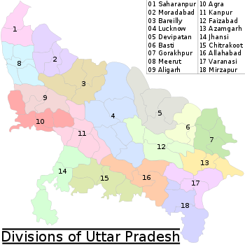
A group of districts forms a division, which is administered by a 'Divisional Commissioner'. Uttar Pradesh is now divided in seventy five districts , grouped under eighteen divisions:
Uttar Pradesh
Uttar Pradesh abbreviation U.P. , is a state located in the northern part of India. With a population of over 200 million people, it is India's most populous state, as well as the world's most populous sub-national entity...
borders with Nepal and the Indian states of Bihar
Bihar
Bihar is a state in eastern India. It is the 12th largest state in terms of geographical size at and 3rd largest by population. Almost 58% of Biharis are below the age of 25, which is the highest proportion in India....
, Jharkhand
Jharkhand
Jharkhand is a state in eastern India. It was carved out of the southern part of Bihar on 15 November 2000. Jharkhand shares its border with the states of Bihar to the north, Uttar Pradesh and Chhattisgarh to the west, Orissa to the south, and West Bengal to the east...
, Chhattisgarh
Chhattisgarh
Chhattisgarh is a state in Central India, formed when the 16 Chhattisgarhi-speaking South-Eastern districts of Madhya Pradesh gained separate statehood on 1 November 2000....
, Madhya Pradesh
Madhya Pradesh
Madhya Pradesh , often called the Heart of India, is a state in central India. Its capital is Bhopal and Indore is the largest city....
, Rajasthan
Rajasthan
Rājasthān the land of Rajasthanis, , is the largest state of the Republic of India by area. It is located in the northwest of India. It encompasses most of the area of the large, inhospitable Great Indian Desert , which has an edge paralleling the Sutlej-Indus river valley along its border with...
, Haryana
Haryana
Haryana is a state in India. Historically, it has been a part of the Kuru region in North India. The name Haryana is found mentioned in the 12th century AD by the apabhramsha writer Vibudh Shridhar . It is bordered by Punjab and Himachal Pradesh to the north, and by Rajasthan to the west and south...
, Uttarakhand
Uttarakhand
Uttarakhand , formerly Uttaranchal, is a state in the northern part of India. It is often referred to as the Land of Gods due to the many holy Hindu temples and cities found throughout the state, some of which are among Hinduism's most spiritual and auspicious places of pilgrimage and worship...
and National Capital Territory of Delhi. The Himalayas
Himalayas
The Himalaya Range or Himalaya Mountains Sanskrit: Devanagari: हिमालय, literally "abode of snow"), usually called the Himalayas or Himalaya for short, is a mountain range in Asia, separating the Indian subcontinent from the Tibetan Plateau...
lies in the north of the state and the Deccan Plateau
Deccan Plateau
The Deccan Plateau is a large plateau in India, making up the majority of the southern part of the country. It rises a hundred meters high in the north, rising further to more than a kilometers high in the south, forming a raised triangle nested within the familiar downward-pointing triangle of...
is at the south. In between them, the river Ganges, Yamuna
Yamuna
The Yamuna is the largest tributary river of the Ganges in northern India...
, Ghaghra flow eastwards.
Uttar Pradesh can be divided into three distinct regions, Southern hills and Gangetic plain
In 1947, when India gained independence, the state of United Provinces
United Provinces of Agra and Oudh
The United Provinces of Agra and Oudh was a province of India under the British Raj, which existed from 1902 to 1947; the official name was shortened by the Government of India Act 1935 to United Provinces, by which the province had been commonly known, and by which name it was also a province of...
was renamed as Uttar Pradesh
Uttar Pradesh
Uttar Pradesh abbreviation U.P. , is a state located in the northern part of India. With a population of over 200 million people, it is India's most populous state, as well as the world's most populous sub-national entity...
. The former princely state of Tehri Garhwal joined on 1 August 1949 and Rampur
Rampur, Uttar Pradesh
Rampur is a city and a municipality located in Rampur District in the Indian state of Uttar Pradesh. Rampur district is located at Longitude 78-0-54 to 69-0-28 East and Latitude 28-25 to 29-10 North and spans an area of 2,367 km².It also gave its name to a former princely state of British...
joined as a district on 1 December 1949. The States Reorganisation Act
States Reorganisation Act
The States Reorganisation Act of 1956 was a major reform of the boundaries and governance of India's states and territories. The act reorganised the boundaries of India's states along linguistic lines, and amended the Indian Constitution to replace the three types of states, known as Parts A, B,...
of 1956 had no major effect on status of Uttar Pradesh. On 9 November 2000 State of Uttaranchal (having Pauri Garhwal, Tehri Garhwal, Uttar Kashi, Chamoli, Dehradun, Nainital, Almora, Pithoragarh, Udham Singh Nagar, Bageshwar, Champawat, Rudraprayag and Hardwar districts) was carved out of Uttar Pradesh.
Uttar Pradesh is now divided into seventy districts under eighteen divisions. Districts are administered by District Magistrates, and divisions are administered by Divisional Commissioners. Lucknow
Lucknow
Lucknow is the capital city of Uttar Pradesh in India. Lucknow is the administrative headquarters of Lucknow District and Lucknow Division....
, the capital of the state, constitutes the Lucknow district
Lucknow District
Lucknow District is a district of Uttar Pradesh state in northern India. The city of Lucknow is the district headquarters and the district is part of Lucknow Division...
.Kanpur is the largest city with population of over 3 million which comes under Kanpur Metropolitan Region
Kanpur Metropolitan Region
The metropolitan region defined under JNNURM by Kanpur Nagar Nigam,includes the Kanpur Nagar,Kanpur Dehat,Fatehpur and Unnao area, In north it is expended 20 kilometer to Unnao town side, in the west its limit is up to Auraiya town limit, in the eastern side the limit has been expanded to the...
. Other districts are further divided into administrative units such as subdivisions and blocks, administered by SDO and BDO, respectively. The Panchayati Raj
Panchayati Raj
The panchayat raj is a South Asian political system mainly in India, Pakistan, and Nepal. "Panchayat" literally means assembly of five wise and respected elders chosen and accepted by the local community. Traditionally, these assemblies settled disputes between individuals and villages...
has a three-tier structure in the state. The atomic unit is called a Gram Panchayat
Gram panchayat
Gram panchayats are local self-governments at the village or small town level in India. As of 2002 there were about 265,000 gram panchayats in India. The gram panchayat is the foundation of the Panchayat System. A gram panchayat can be set up in villages with minimum population of 300...
, which is the Panchayat organization for a collection of villages. The block-level organizations are called Panchayat Samiti, and the district-level organizations are named Zilla Parishad.
Administrative structure
District collector
The District Collector is the district head of administration of the bureaucracy in a state of India. Though he/she is appointed and is under general supervision of the state government, he/she has to be a member of the elite IAS recruited by the Central Government...
, who is better known as a District Magistrate (DM) in the state of Uttar Pradesh. A DM is an officer from Indian Administrative Service
Indian Administrative Service
The Indian Administrative Service is the administrative civil service of the Government of India. It is one of the three All India Services....
(IAS) and is appointed by the State Government of Uttar Pradesh. Each district is divided into subdivisions. A subdivision is governed by a sub-divisional magistrate
Sub-Divisional Magistrate
A Sub-Divisional Magistrate is a title sometimes given to the head official of a country subdivision, an administrative unit that is sometimes below the level of district, depending on a country's government structure....
(SDM), better known as a Sub-Divisional Officer (SDO). Other than urban units such as town municipalities, a subdivision contains 'community development blocks' (also known as CD blocks or blocks). A block consists of urban units such as census town
Census town
In India, a census town is one which has:# A minimum population of 5,000# At least 75% of male working population engaged in non-agricultural pursuits# A density of population of at least 400 persons per km2.In Ireland, a census town is;...
s and rural units called gram panchayat
Gram panchayat
Gram panchayats are local self-governments at the village or small town level in India. As of 2002 there were about 265,000 gram panchayats in India. The gram panchayat is the foundation of the Panchayat System. A gram panchayat can be set up in villages with minimum population of 300...
s. A block is administered by a Block Development Officer (BDO), who is appointed by the Government of Uttar Pradesh.
A gram panchayat, which consists of a group of villages, is administered by a village council headed by a Pradhan
Sarpanch
A sarpanch is a democratically elected head of a village level statutory institution of local self-government called the gram panchayat in India and Pakistan. He, together with other elected Panchas , constitute the Gram Panchayat. The Sarpanch is the focal point of contact between government...
.
A District Superintendent of Police, better known as a Superintendent of Police, heads the District Police organization of Uttar Pradesh Police
Uttar Pradesh Police
Uttar Pradesh Police is the police force of the state of Uttar Pradesh. UP Police is the largest police force in the world working under a single command.The Uttar Pradesh Police was formed in 1861 when the Indian Police Act came to be operational...
. This is as per the Police Act of 1861, which is applicable to the whole of India. The Superintendents of Police are officers of the Indian Police Service
Indian Police Service
The Indian Police Service , simply known as Indian Police or IPS, is one of the three All India Services of the Government of India...
. For every subdivision, there is a Subdivision Police, headed by a Police officer of the rank of Assistant Superintendent of Police or Deputy Superintendent of Police. Under subdivisions, there are Police Circles, each headed by an Inspector of Police. A Police Circle consists of Police Stations, each headed by an Inspector of Police, or in case of rural areas, by a Sub-Inspector of Police.
The Allahabad High Court
Allahabad High Court
The Allahabad High Court or the High Court of Judicature at Allahabad is a high court having jurisdiction over the Indian state of Uttar Pradesh since 1950...
has the jurisdiction of the state of Uttar Pradesh. Though most of the districts have more courts other than a District Court, not every subdivision of the state has a Court.
A group of districts forms a division, which is administered by a 'Divisional Commissioner'. Uttar Pradesh is now divided in seventy five districts , grouped under eighteen divisions:
Alphabetical listing of divisions
| Division | Headquarters | Districts | Map |
| Agra division Agra Division Agra Division is an administrative unit of Indian state of Uttar Pradesh. Agra Division consists of:-*Agra District*Firozabad District*Mainpuri District*Mathura District... |
Agra Agra Agra a.k.a. Akbarabad is a city on the banks of the river Yamuna in the northern state of Uttar Pradesh, India, west of state capital, Lucknow and south from national capital New Delhi. With a population of 1,686,976 , it is one of the most populous cities in Uttar Pradesh and the 19th most... |
|
 |
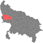
| Aligarh division Aligarh Division Aligarh division is an administrative unit of Indian state of Uttar Pradesh. Aligarh division consists of:-*Aligarh District*Etah District*Mahamayanagar District*Kanshiram Nagar District-See also:Districts of Uttar Pradesh... |
Aligarh |
Aligarh District Aligarh District is a district in the northern Indian state of Uttar Pradesh. Its district seat is located in the city of Aligarh .The Aligarh District belongs to Aligarh Division... Etah District Etah district is one of the districts of Uttar Pradesh state of India, and Etah town is the district headquarters. Etah district is a part of Aligarh Division. It is dominated by Yadavs and Rajputs.-Economy:... |
 |
| Allahabad division Allahabad Division Allahabad division is an administrative unit of Indian state of Uttar Pradesh.The original Allahabad division consisted of all the districts of the lower Doab, viz.:-* Etawah district* Farrukhabad district* Kanpur district* Fatehpur district... |
Allahabad Allahabad Allahabad , or Settled by God in Persian, is a major city of India and is one of the main holy cities of Hinduism. It was renamed by the Mughals from the ancient name of Prayaga , and is by some accounts the second-oldest city in India. It is located in the north Indian state of Uttar Pradesh,... |
Allahabad District Allahabad district is one of the districts of Uttar Pradesh state of India, and Allahabad town is the district headquarters. Allahabad district is a part of Allahabad Division.As of 2011 it is the most populous district of Uttar Pradesh .... Fatehpur district Fatehpur district is one of the 71 districts of Uttar Pradesh state in northern India. The district covers an area of 4,152 km². The district has a population of 2,308,384 . Fatehpur city is the administrative headquarters of the district. Located on the banks of the sacred rivers Ganges and... Kaushambi District Kaushambi district is one of the districts of Uttar Pradesh state of India, and Manjhanpur town is the district headquarters. Kaushambi district is a part of Allahabad Division.- History :... |
 |
| Azamgarh division Azamgarh Division Azamgarh division is an administrative unit of Indian state of Uttar Pradesh. Azamgarh division consists of:-* Azamgarh District* Ballia District* Mau District-See also:* Districts of Uttar Pradesh... |
Azamgarh Azamgarh Azamgarh is a town in the Indian state of Uttar Pradesh. It is headquarters of Azamgarh district and Azamgarh Division.-History:Azamgarh, one of the easternmost districts of the State, once formed a part of the ancient Kosala kingdom, except the north-eastern part of it which was included in the... |
Azamgarh district Azamgarh district is one of the three districts of Azamgarh Division in the Indian state of Uttar Pradesh.-Etymology:The district is named after its headquarters town, Azamgarh. Azam, son of Vikramajit, founded the town in 1665. Vikramajit a descendant of Gautam Rajputs of Mehnagar in pargana... Ballia District Ballia district is one of the districts of Uttar Pradesh state, India. Ballia district is a part of Azamgarh Division situated in eastern Part of Uttar Pradesh. Main occupation is agriculture. Ballia City is district headquarters and commercial Market of this district. There are four Tehsil in... Mau district Mau district is one of the districts of Uttar Pradesh state of India and Mau town is the district headquarters. Mau district is a part of Azamgarh Division. Mau district is situated in the south-eastern part of the state with headquarters at Mau town... |
 |
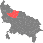
| Bareilly division Bareilly Division Bareilly division is an administrative geographical unit of Uttar Pradesh state of India. Bareilly is the administrative headquarters of the division. Currently , the division consists of districts of* Bareilly District* Badaun District... |
Bareilly Bareilly Bareilly is a prominent city in Bareilly district in the northern Indian state of Uttar Pradesh. Standing on the Ramganga river, it is the capital of the Bareilly division and the geographical region Rohilkhand... |
Badaun District Budaun district is one of the districts of Uttar Pradesh state of India, and Budaun town is the district headquarters. Budaun district is a part of Bareilly division. The district covers an area of 5168 km²... Bareilly District Bareilly district is one of the districts of Uttar Pradesh state in northern India. City of Bareilly is the district headquarters. The district consists of six tehsils. These are: Aonla, Baheri, City of Bareilly, Faridpur, Meerganj and Nawabganj. Bareilly district is a part of Bareilly Division.... Pilibhit District Pilibhit district is one of the districts in the state of Uttar Pradesh in India, and Pilibhit city is the district headquarters. Pilibhit district is a part of Bareilly Division.The city is famous for its contribution to Bollywood, Urdu literature and its involvement in Politics of India... Shahjahanpur District Shahjahanpur district is one of the historical districts of Uttar Pradesh in the republic of India. It is a part of Bareilly division. The main town is Shahjahanpur and its Tehsils are: Powayan, Tilhar, Jalalabad, and Kanth.... |
 |
| Basti division Basti Division Basti Division is an administrative geographical unit of Uttar Pradesh state of India. Basti is the administrative headquarters of the division. Currently , the division consists following districts:* Basti,* Sidhartha Nagar, and* Sant Kabir Nagar.... |
Basti Basti, Uttar Pradesh Basti is a town and a municipal board in Basti district in the Indian state of Uttar Pradesh.-Geography:LOCATION & BOUNDARIES:- The district lies between the parallels of 26° 23' and 27° 30' North and Latitude and 82° 17' and 83° 20' East longitude. Its maximum length from north to south is about... |
Sant Kabir Nagar District Sant Kabir Nagar district is one of the 72 districts of Uttar Pradesh state in northern India. Khalilabad town is the district headquarters. Sant Kabir Nagar district is a part of Basti Division. The district is bounded on the north by Siddharthnagar and Maharajganj districts, on the east by... |
 |
| Chitrakoot division Chitrakoot Division Chitrakoot Division is an administrative division of Uttar Pradesh state in northern India. It includes the districts of :* Banda,* Chitrakoot,* Hamirpur, and* Mahoba.... |
Chitrakoot |
Banda District Banda district is a district of Uttar Pradesh state of India, and Banda is the district headquarters. It is a part of Chitrakoot Division.Banda is famous for its Shajar stone, used for making jewellery, and the historically and architecturally significant sites Khajuraho and Kalinjar. Khajuraho is... Chitrakoot District Chitrakoot district is one of the districts of Uttar Pradesh state of India, and Chitrakoot town is the district headquarters. Chitrakoot district is a part of Chitrakoot Division. The district occupies an area of 3,205 km². The district has a population of 766,225... Hamirpur District, Uttar Pradesh Hamirpur district is one of the 70 districts of Uttar Pradesh state of India and Hamirpur town is the district headquarters. Hamirpur district is a part of Chitrakoot Division. The district occupies an area of 4,121.9 km². The district has a population of 1,042,374... Mahoba District Mahoba district is one of the districts of Uttar Pradesh state of India and Mahoba town is the district headquarters. Mahoba district is a part of Chitrakoot Division. The district occupies an area of 2884 km². It has a population of 708,447... |
 |
| Devipatan division Devipatan Division Devipatan division is an administrative geographical unit of Uttar Pradesh state of India. Currently , the division consists of districts of :* Gonda,* Bahraich,* Shravasti, and* Balarampur.Gonda is headquarter of this division.... |
Gonda Gonda District Gonda is one of the districts of Uttar Pradesh, India. Gonda is the district headquarters, and also the administrative centre for the Devipatan Division.... |
Bahraich District Bahraich District is one of the districts of Uttar Pradesh state of India, and Bahraich town is the district headquarters. Bahraich District is a part of Devipatan Division.-History:... Gonda District Gonda is one of the districts of Uttar Pradesh, India. Gonda is the district headquarters, and also the administrative centre for the Devipatan Division.... Shravasti District Shravasti District is one of the districts of the Uttar Pradesh state of India and Bhinga town is district headquarter. Shravasti district is a part of Devipatan Division... |
 |
| Faizabad division Faizabad Division See also: Faizabad Faizabad division is an administrative geographical unit of Uttar Pradesh state in India. Faizabad is the administrative headquarters of the division. The division consists of districts of :* Faizabad,... |
Faizabad Faizabad City of Faizabad , previous capital of Awadh, is the headquarters of Faizabad District and a municipal board in the state of Uttar Pradesh, India, situated on the banks of river Ghaghra . Faizabad has a twin city of Ayodhya, which is considered to be the birthplace of Rama... |
Ambedkar Nagar district Ambedkar Nagar district is a district in the Faizabad division. It was formed in 1995 by the then chief minister of Uttar Pradesh, Ms. Mayawati, and was named after one of the most contributing personalities in Indian legislation, Dr.Bhimrao Ambedkar.-Geography:The total area of the district is... Barabanki District The Barabanki district is one of four districts of Faizabad division, lies at the very heart of Awadh region of Uttar Pradesh state of India, and forms as it were a centre from which no less than seven other districts radiate... Faizabad District See also: Faizabad Faizabad district is one of the 71 districts of Uttar Pradesh state in northern India. Faizabad city is the administrative headquarters of this district. The district occupies an area of 2,764 km²... Sultanpur District Sultanpur District is a district in the state of Uttar Pradesh in northern India. The district is a part of Faizabad Division. Its administrative head is Sultanpur.-History:... |
 |
| Gorakhpur division Gorakhpur Division Gorakhpur division is an administrative geographical unit of Uttar Pradesh state in northern India. Gorakhpur is the administrative headquarters of the division. Currently , the division consists of districts of Gorakhpur, Kushinagar, Deorria, and Maharajganj.... |
Gorakhpur Gorakhpur Gorakhpur is a city in the eastern part of the state of Uttar Pradesh in India, near the border with Nepal. It is the administrative headquarters of Gorakhpur District and Gorakhpur Division. Gorakhpur is one of the proposed capitals of the Purvanchal state which is yet to be formed... |
Deoria District Deoria district is one of the districts of Uttar Pradesh state of India, and Deoria town is the district headquarters. Deoria district is a part of Gorakhpur division.-Ancient:... Gorakhpur District Gorakhpur district is a district of Uttar Pradesh state in India. Gorakhpur is the administrative headquarters of the district.-History:The district was ceded by the Nawab of Awadh to the British East India Company in 1801. With this cession, Gorakhpur was raised to the status of a district. The... Kushinagar District Kushinagar District is a district of Uttar Pradesh state in northern India. Padarauna is the district headquarters. The district is named for Kushinagar, a Buddhist pilgrimage site where Gautama Buddha attained parinirvana in the 6th or 5th centuries BCE.... Maharajganj District Maharajganj district is one of the 71 districts of Uttar Pradesh state in northern India, and the town of Maharajganj is the district headquarters.-Geography:... |
 |
| Jhansi division Jhansi Division Jhansi Division is one of 17 divisions of Uttar Pradesh state in northern India. It includes Jhansi, Jalaun, and Lalitpur districts. The city of Jhansi is the administrative center. The division is part of the historic Bundelkhand region, which includes a portion of southern Uttar Pradesh and... |
Jhansi Jhansi Jhansi Hindi:झाँसी, , Marathi: झाशी, is a historical city of India. Jhansi is the administrative headquarters of Jhansi District and Jhansi Division. The original walled city grew up around its stone fort, which crowns a neighboring rock. This district is on the bank of river Betwa.The National... |
Jalaun District Jalaun District is a district of Uttar Pradesh state of India.The district is named after town of Jalaun, which was the former headquarters of a Maratha governor, but the administrative headquarters of the district is at Orai. Other large towns in the district are Kalpi, Konch, and... Jhansi District Jhansi District is one of the districts of Uttar Pradesh state in northern India. The town of Jhansi is the district headquarters.The district is bordered on the north by Jalaun District, to the east by Hamirpur and Mahoba districts, to the south by Tikamgarh District of Madhya Pradesh state, to... Lalitpur District, Uttar Pradesh Lalitpur District is one of the districts of Uttar Pradesh state of India. Lalitpur district is a part of Jhansi Division. Lalitpur is the main town and administrative headquarters. The district occupies an area of 5,039 km².... |
 |
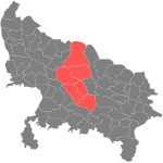
| Kanpur division Kanpur Division Kanpur division is an administrative geographical unit of Uttar Pradesh state of India. Kanpur is the administrative headquarters of the division... |
Kanpur |
Auraiya district Auraiya district is one of the districts of Uttar Pradesh state of India, and Auraiya town is the district headquarters.-History:On 17 September 1997 two tehsils named Auraiya and Bidhuna were separated from district Etawah to form the new district named as Auraiya.-Geography:The district of... Etawah District Etawah district is a district in the southwestern portion of Uttar Pradesh state of India. Etawah town is the district headquarters. Etawah district is part of Kanpur Division. The district covers an area of 2311 km²... Farrukhabad District Farrukhabad district is a district of Uttar Pradesh state in northern India. The town of Fatehgarh is the district headquarters. The district is part of Kanpur Division.... Kannauj District Kannauj District is an administrative district of Uttar Pradesh state in northern India, along the river Ganges. The historic town of Kannauj, northwest of Kanpur, is the administrative center.-Geography:... Kanpur Dehat district Ramabai Nagar district , formerly known as Kanpur Dehat district, is a district of Uttar Pradesh state in northern India. The administrative headquarters of the district are at Mati, Akbarpur. This district is part of Kanpur division.-History:... Kanpur District Kanpur district is one of the districts of the Uttar Pradesh state of India. It is a part of Kanpur division and its district headquarters is Kanpur. Due to increase in population of Kanpur District, for proper administration it has been divided into two. The term Kanpur refers to the combination... |
 |
| Lucknow division Lucknow Division Lucknow division is an administrative geographical unit of Uttar Pradesh state of India. Lucknow is the administrative headquarters of the division. As of 2005, the division consists ofLucknow, Hardoi, Lakhimpur Kheri, Raebareli, Sitapur, and Unnao.... |
Lucknow Lucknow Lucknow is the capital city of Uttar Pradesh in India. Lucknow is the administrative headquarters of Lucknow District and Lucknow Division.... |
Hardoi District Hardoi disctrict is a district of Uttar Pradesh, India, and Hardoi town is the district headquarters. Hardoi district is a part of Lucknow division.-Economy:... Lakhimpur Kheri Lakhimpur Kheri is a district of Uttar Pradesh in the Lucknow division. It is located in India along the border with Nepal. The headquarters of the Lakhimpur Kheri District are situated in the city of Lakhimpur.... Lucknow District Lucknow District is a district of Uttar Pradesh state in northern India. The city of Lucknow is the district headquarters and the district is part of Lucknow Division... Raebareli District Raebareli District is a district of Uttar Pradesh state in northern India. The town of Raebareli is the district headquarters. The district is part of Lucknow Division.-Raebareli District in 1911:... Sitapur District Sitapur district is one of the districts of Uttar Pradesh state of India, with Sitapur town as the district headquarters. Sitapur district is a part of Lucknow division. This district covers an area of 5743 km². It has a population of 3,619,661.... Unnao District Unnao District is a district of Uttar Pradesh state in northern India. The town of Unnao is the district headquarters. The district is part of Lucknow Division.-History:... |
 |
| Meerut division Meerut Division Meerut division is an administrative geographical unit of Uttar Pradesh state of India. Meerut is the administrative headquarters of the division. Currently, the division consists of districts of Meerut, Bulandshahr, Buddha Nagar, Ghaziabad, and Bagh Path.... |
Meerut |
Bagpat District Baghpat district is one of the 71 districts of Uttar Pradesh state of India, and Baghpat town is the district headquarters. This district covers an area of 1321 km². The district has a population of 1,163,991.-Economy:... Bulandshahr District Bulandshahar District is a district of Uttar Pradesh state in northern India. Bulandshahr city is the district headquarters.-Geography:... Meerut District Meerut district , is one of the districts of Uttar Pradesh state of India, and Meerut is the district headquarters. Meerut district is a part of Meerut division.-Demographics:... Panchsheel Nagar district Panchsheel Nagar district was announced on 28 September 2011 as one of three new districts of Uttar Pradesh state of India. Panchsheel Nagar district is a part of Meerut division.... (Hapur Hapur Hapur is a city with a population of 216,100 located 65 kilometers east of the capital of India and noted as manufacturing hub of making Stainless Steel Pipes and Tubes, Hapur is also famous for paper cones and tubes.... ) |
 |
| Mirzapur division Mirzapur Division -About Mirzapur Mandal:Mirzapur division is an administrative geographical unit of Uttar Pradesh state of India. Mirzapur is the administrative headquarters of the division... |
Mirzapur Mirzapur Mirzapur is a city in the heart of North India, nearly 650 km between Delhi and Kolkata and also equidistant from Allahabad and Varanasi. Located in the state of Uttar Pradesh, Mirzapur has a population of a little over 205,264 and is renowned for its famous carpet and brassware industry... |
Mirzapur District Mirzapur district is one of the 70 districts of Uttar Pradesh state in northern India. The district is bounded on the north by Sant Ravidas Nagar and Varanasi districts, on the east by Chandauli district, on the south by Sonbhadra district and on the norhwest by Allahabad district. The district... |
 |
| Moradabad division Moradabad Division Moradabad division is an administrative geographical unit of Uttar Pradesh state of India. Moradabad is the administrative headquarters of the division. Currently , the division consists of districts of Moradabad, Bijnor, Rampur, Jyotiba Rao Phule Nagar and Bhim Nagar. muslims are main community.... |
Moradabad Moradabad Moradabad is a city and a municipal corporation in Moradabad district in the Indian state of Uttar Pradesh. It was established in 1600 by prince Murad, the son of the Mughal Emperor Shah Jahan; as a result the city came to be known as Moradabad. It is the administrative headquarters of... |
Bhimnagar district Bhimnagar district was announced on 28 September 2011 as one of three new districts of Uttar Pradesh state of India. The district headquarters is Chandausi fulfills all the conditions to make District Head Quarter. Bhimnagar district is a part of Moradabad division.-References:... (Sambhal Sambhal Sambhal is a town and tehsil and headquarters of Bhimnagar district in the North Indian state of Uttar Pradesh. Sambhal is an ancient settlement that was also important during the period of Muslim rule and was one of Sikandar Lodi ’s provincial capitals in the late 15th and early 16th... ) Bijnor District Bijnor is a district of Uttar Pradesh state of India. Bijnor city is the district headquarters.-Geography :... Jyotiba Phule Nagar District Jyotiba Phule Nagar district is one of the 72 districts of Uttar Pradesh state in northern India. Amroha town is the district headquarters. According to Government of India, the district is one of the Minority Concentrated District in India on the basis of the 2001 census data on population,... Moradabad District Moradabad district is one of the districts of Uttar Pradesh state of India, and Moradabad town is the district headquarters. Moradabad district is a part of Moradabad division... Rampur District Rampur district is one of the districts of Uttar Pradesh state of India, and Rampur town is the district headquarters. Rampur district is a part of Moradabad division. The district occupies an area of 2,367 km²... |
 |
| Saharanpur division Saharanpur Division Saharanpur division is an administrative geographical unit of Uttar Pradesh state of India. The city of Saharanpur is the administrative headquarters of the division.- Administrative jurisdiction :... |
Saharanpur Saharanpur Saharanpur is a city and a Municipal Corporation in the state of Uttar Pradesh in northern India. It is the administrative headquarters of Saharanpur District as well as Saharanpur Division... |
Muzaffarnagar District Muzaffarnagar district is a district of Uttar Pradesh state in northern India. It is part of Saharanpur division. The town of Muzaffarnagar is the district headquarters.-Communication:... Shamli Shamli is a city, tehsil and now a district headquarters in the Indian state of Uttar Pradesh. It is located on the Delhi - Saharanpur highway. It is around 100 km from Delhi, 38 km from Panipat and 65 km from Saharanpur... ) Saharanpur District Saharanpur district is the northernmost of the districts of Uttar Pradesh state, India. Bordering the states of Haryana and Uttarakhand, and close to the foothills of Shivalik range, it lies in the northern part of the Doab region... |
 |
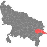
| Varanasi division Varanasi Division Varanasi division is an administrative geographical unit of Uttar Pradesh state of India. Varanasi is the administrative headquarters of the division. Currently , the division consists of districts of Varanasi, Chandauli, Ghazipur, and Jaunpur.... |
Varanasi Varanasi -Etymology:The name Varanasi has its origin possibly from the names of the two rivers Varuna and Assi, for the old city lies in the north shores of the Ganga bounded by its two tributaries, the Varuna and the Asi, with the Ganges being to its south... |
Chandauli District Chandauli District is a district of Uttar Pradesh state of India, and Chandauli town is the district headquarters. Chandauli district is a part of Varanasi Division.... Ghazipur District Ghazipur District is a district of Uttar Pradesh state in northern India. The city of Ghazipur is the district headquarters. The district is part of Varanasi Division... Jaunpur District Jaunpur is a district in the Varanasi Division of Uttar Pradesh state in India. Jaunpur serves as the district headquarters.-Geography:The district of Jaunpur is situated in the North-West part of Varanasi Division. Its land area extends from 24.240N to 26.120N latitude and between 82.70E and... Varanasi District Varanasi district is one of the districts of Uttar Pradesh state in northern India, with Varanasi city as the district headquarters. Varanasi district is a part of Varanasi division. The district occupies an area of 1,535 km². The district has a population of 3,138,671 .-Divisions:The... |
 |
Alphabetical listing of districts
| Code | District | Headquarters | Population | Area (km2) | Density (/km2 | Map | ||
| AG | Agra Agra District Agra District is one of the 70 districts of Uttar Pradesh state of India, and the historical city of Agra is the district headquarters. Agra district is a part of Agra division.-Geography:... |
Agra Agra Agra a.k.a. Akbarabad is a city on the banks of the river Yamuna in the northern state of Uttar Pradesh, India, west of state capital, Lucknow and south from national capital New Delhi. With a population of 1,686,976 , it is one of the most populous cities in Uttar Pradesh and the 19th most... |
3,611,301 | 4,027 | 897 | |||
| AH | Allahabad Allahabad District Allahabad district is one of the districts of Uttar Pradesh state of India, and Allahabad town is the district headquarters. Allahabad district is a part of Allahabad Division.As of 2011 it is the most populous district of Uttar Pradesh .... |
Allahabad Allahabad Allahabad , or Settled by God in Persian, is a major city of India and is one of the main holy cities of Hinduism. It was renamed by the Mughals from the ancient name of Prayaga , and is by some accounts the second-oldest city in India. It is located in the north Indian state of Uttar Pradesh,... |
4,941,510 | 5,424 | 911 | |||
| AL | Aligarh Aligarh District Aligarh District is a district in the northern Indian state of Uttar Pradesh. Its district seat is located in the city of Aligarh .The Aligarh District belongs to Aligarh Division... |
Aligarh | 2,990,388 | 3,747 | 798 | |||
| AN | Ambedkar Nagar Ambedkar Nagar District Ambedkar Nagar district is a district in the Faizabad division. It was formed in 1995 by the then chief minister of Uttar Pradesh, Ms. Mayawati, and was named after one of the most contributing personalities in Indian legislation, Dr.Bhimrao Ambedkar.-Geography:The total area of the district is... |
Akbarpur Akbarpur, Ambedkar Nagar Akbarpur is a city and a municipal board in Ambedkar Nagar district in the state of Uttar Pradesh, India... |
2,025,373 | 2,372 | 854 | |||
| AU | Auraiya Auraiya district Auraiya district is one of the districts of Uttar Pradesh state of India, and Auraiya town is the district headquarters.-History:On 17 September 1997 two tehsils named Auraiya and Bidhuna were separated from district Etawah to form the new district named as Auraiya.-Geography:The district of... |
Auraiya Auraiya Auraiya is a city and a municipal board in Auraiya district in the state of Uttar Pradesh, India. It is district headquarters as well.NH 2 passes through the center of the town.Dibiyapur RS is nearest Railway Station.Kanpur Airport is nearest airport.... |
1,179,496 | 2,051 | 575 | |||
| AZ | Azamgarh Azamgarh district Azamgarh district is one of the three districts of Azamgarh Division in the Indian state of Uttar Pradesh.-Etymology:The district is named after its headquarters town, Azamgarh. Azam, son of Vikramajit, founded the town in 1665. Vikramajit a descendant of Gautam Rajputs of Mehnagar in pargana... |
Azamgarh Azamgarh Azamgarh is a town in the Indian state of Uttar Pradesh. It is headquarters of Azamgarh district and Azamgarh Division.-History:Azamgarh, one of the easternmost districts of the State, once formed a part of the ancient Kosala kingdom, except the north-eastern part of it which was included in the... |
3,950,808 | 4,234 | 933 | |||
| BB | Barabanki Barabanki District The Barabanki district is one of four districts of Faizabad division, lies at the very heart of Awadh region of Uttar Pradesh state of India, and forms as it were a centre from which no less than seven other districts radiate... |
Barabanki | 2,673,394 | 3,825 | 699 | |||
| BD | Badaun Badaun District Budaun district is one of the districts of Uttar Pradesh state of India, and Budaun town is the district headquarters. Budaun district is a part of Bareilly division. The district covers an area of 5168 km²... |
Badaun | 3,069,245 | 5,168 | 594 | |||
| BH | Bahraich Bahraich District Bahraich District is one of the districts of Uttar Pradesh state of India, and Bahraich town is the district headquarters. Bahraich District is a part of Devipatan Division.-History:... |
Bahraich Bahraich Bahraich is a city and a municipal board in Bahraich district in the state of Uttar Pradesh, India. Located on the Saryu River, a tributary of river Ghaghra, Bahraich is 125 km north-east of Lucknow, the state capital. The towns of Barabanki, Gonda, Balrampur, Lakhimpur and Sitapur share... |
2,384,239 | 5,745 | 415 | |||
| BI | Bijnor Bijnor District Bijnor is a district of Uttar Pradesh state of India. Bijnor city is the district headquarters.-Geography :... |
Bijnor Bijnor Bijnor variously spelt as Bijnaur and Bijnour, is a city and a municipal board in Bijnor district in the state of Uttar Pradesh, India... |
3,130,586 | 4,561 | 686 | |||
| BL | Ballia Ballia District Ballia district is one of the districts of Uttar Pradesh state, India. Ballia district is a part of Azamgarh Division situated in eastern Part of Uttar Pradesh. Main occupation is agriculture. Ballia City is district headquarters and commercial Market of this district. There are four Tehsil in... |
Ballia Ballia Ballia is a city with a municipal board in the Indian state of Uttar Pradesh. The eastern boundary of the city lies at the junction of the Ganges and the Ghaghara... |
2,752,412 | 2,981 | 923 | |||
| BN | Banda District Banda District Banda district is a district of Uttar Pradesh state of India, and Banda is the district headquarters. It is a part of Chitrakoot Division.Banda is famous for its Shajar stone, used for making jewellery, and the historically and architecturally significant sites Khajuraho and Kalinjar. Khajuraho is... |
Banda | 1,500,253 | 4,413 | 340 | |||
| BP | Balrampur Balrampur district Balrampur district is one of the 72 districts of Uttar Pradesh state in India. Balrampur town located on the bank of the Rapti is the district headquarters. Balrampur district is a part of Devipatan division, and historic Awadh region.... |
Balrampur Balrampur Balrampur is a city and a municipal board in Balrampur district in the state of Uttar Pradesh, India. It is situated on the bank of river Rapti and is the district headquarters of Balarampur district... |
1,684,567 | 2,925 | 576 | |||
| BR | Bareilly Bareilly District Bareilly district is one of the districts of Uttar Pradesh state in northern India. City of Bareilly is the district headquarters. The district consists of six tehsils. These are: Aonla, Baheri, City of Bareilly, Faridpur, Meerganj and Nawabganj. Bareilly district is a part of Bareilly Division.... |
Bareilly Bareilly Bareilly is a prominent city in Bareilly district in the northern Indian state of Uttar Pradesh. Standing on the Ramganga river, it is the capital of the Bareilly division and the geographical region Rohilkhand... |
3,598,701 | 4,120 | 873 | |||
| BS | Basti | Basti Basti, Uttar Pradesh Basti is a town and a municipal board in Basti district in the Indian state of Uttar Pradesh.-Geography:LOCATION & BOUNDARIES:- The district lies between the parallels of 26° 23' and 27° 30' North and Latitude and 82° 17' and 83° 20' East longitude. Its maximum length from north to south is about... |
2,068,922 | 3,034 | 682 | |||
| BU | Bulandshahr Bulandshahr District Bulandshahar District is a district of Uttar Pradesh state in northern India. Bulandshahr city is the district headquarters.-Geography:... |
Bulandshahr | 2,923,290 | 3,719 | 786 | |||
| CD | Chandauli Chandauli District Chandauli District is a district of Uttar Pradesh state of India, and Chandauli town is the district headquarters. Chandauli district is a part of Varanasi Division.... |
Chandauli Chandauli Chandauli , also known as Chandoli, is a town and a nagar panchayat in Chandauli district in the state of Uttar Pradesh, India. It is the administrative headquarters of Chandauli District.-Geography:... |
1,639,777 | 2,554 | 642 | |||
| CT | Chitrakoot Chitrakoot District Chitrakoot district is one of the districts of Uttar Pradesh state of India, and Chitrakoot town is the district headquarters. Chitrakoot district is a part of Chitrakoot Division. The district occupies an area of 3,205 km². The district has a population of 766,225... |
Chitrakoot | 800,592 | 3,202 | 250 | |||
| DE | Deoria Deoria District Deoria district is one of the districts of Uttar Pradesh state of India, and Deoria town is the district headquarters. Deoria district is a part of Gorakhpur division.-Ancient:... |
Deoria | 2,730,376 | 2,535 | 1,077 | |||
| ET | Etah Etah District Etah district is one of the districts of Uttar Pradesh state of India, and Etah town is the district headquarters. Etah district is a part of Aligarh Division. It is dominated by Yadavs and Rajputs.-Economy:... |
Etah Etah Etah is a town which is also the district headquarters of Etah district of Uttar Pradesh state, India.-Geography:Etah is located at . It has an average elevation of 170 metres .... |
2,788,270 | 4,446 | 627 | |||
| EW | Etawah Etawah District Etawah district is a district in the southwestern portion of Uttar Pradesh state of India. Etawah town is the district headquarters. Etawah district is part of Kanpur Division. The district covers an area of 2311 km²... |
Etawah Etawah Etawah is a city on the Yamuna River in the state of Uttar Pradesh in India. It is the administrative headquarters of Etawah District. The city was an important center for the Revolt of 1857 . Also is the place of sangam or confluence between Yamuna and Chambal... |
1,340,031 | 2,287 | 586 | |||
| FI | Firozabad Firozabad District Firozabad district forms one of the western districts of the Indian state of Uttar Pradesh, which has Firozabad Town as its district headquarters. The district is a part of the Agra division and has a total population of 836,808... |
Firozabad Firozabad Firozabad is a city in India, in the state of Uttar Pradesh.The ancient name of this town was Chandwar nagar; it is said that once in reign of Akbar the great, revenue was being brought through the city. it was looted by the people who lived here... |
2,045,737 | 2,361 | 866 | |||
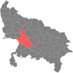
| FR | Farrukhabad Farrukhabad District Farrukhabad district is a district of Uttar Pradesh state in northern India. The town of Fatehgarh is the district headquarters. The district is part of Kanpur Division.... |
Fatehgarh Fatehgarh Fatehgarh is a cantonment town in Farrukhabad district in the state of Uttar Pradesh, India. It is located on the right bank of the Ganges River. It is the administrative headquarters of Farrukhabad District. Fatehgarh derives its name from an old fort. It is a small city with no significant... |
1,577,237 | 2,279 | 692 | |||
| FT | Fatehpur Fatehpur district Fatehpur district is one of the 71 districts of Uttar Pradesh state in northern India. The district covers an area of 4,152 km². The district has a population of 2,308,384 . Fatehpur city is the administrative headquarters of the district. Located on the banks of the sacred rivers Ganges and... |
Fatehpur Fatehpur, Fatehpur Fatehpur is a city and a municipal board in Fatehpur district in the state of Uttar Pradesh, India.-Geography:Fatehpur is located at . It has an average elevation of 110 metres... |
2,305,847 | 4,152 | 555 | |||
| FZ | Faizabad Faizabad District See also: Faizabad Faizabad district is one of the 71 districts of Uttar Pradesh state in northern India. Faizabad city is the administrative headquarters of this district. The district occupies an area of 2,764 km²... |
Faizabad Faizabad City of Faizabad , previous capital of Awadh, is the headquarters of Faizabad District and a municipal board in the state of Uttar Pradesh, India, situated on the banks of river Ghaghra . Faizabad has a twin city of Ayodhya, which is considered to be the birthplace of Rama... |
2,087,914 | 2,765 | 755 | |||
| GB | Gautam Buddha Nagar | NOIDA | 1,191,263 | 1,269 | 939 | |||
| GN | Gonda Gonda District Gonda is one of the districts of Uttar Pradesh, India. Gonda is the district headquarters, and also the administrative centre for the Devipatan Division.... |
Gonda Gonda District Gonda is one of the districts of Uttar Pradesh, India. Gonda is the district headquarters, and also the administrative centre for the Devipatan Division.... |
2,765,754 | 4,425 | 625 | |||
| GP | Ghazipur Ghazipur District Ghazipur District is a district of Uttar Pradesh state in northern India. The city of Ghazipur is the district headquarters. The district is part of Varanasi Division... |
Ghazipur Ghazipur Ghazipur , or Ghazipur City, previously spelt Ghazeepore, is a city/town and a municipal corporation and headquarter of Ghazipur district in the state of Uttar Pradesh, India. It is the administrative headquarters of Ghazipur Division and Sub-division... |
3,049,337 | 3,377 | 903 | |||
| GR | Gorkakhpur Gorakhpur District Gorakhpur district is a district of Uttar Pradesh state in India. Gorakhpur is the administrative headquarters of the district.-History:The district was ceded by the Nawab of Awadh to the British East India Company in 1801. With this cession, Gorakhpur was raised to the status of a district. The... |
Gorakhpur Gorakhpur Gorakhpur is a city in the eastern part of the state of Uttar Pradesh in India, near the border with Nepal. It is the administrative headquarters of Gorakhpur District and Gorakhpur Division. Gorakhpur is one of the proposed capitals of the Purvanchal state which is yet to be formed... |
3,784,720 | 3,325 | 1,138 | |||
| GZ | Ghaziabad Ghaziabad District Ghaziabad district is a largely suburban district of Uttar Pradesh state in northern India of National Capital Region . The town of Ghaziabad is the administrative headquarters of the district. This district is part of Meerut Division... |
Ghaziabad | 3,289,540 | 1,956 | 1,682 | |||
| HM | Hamirpur Hamirpur District, Uttar Pradesh Hamirpur district is one of the 70 districts of Uttar Pradesh state of India and Hamirpur town is the district headquarters. Hamirpur district is a part of Chitrakoot Division. The district occupies an area of 4,121.9 km². The district has a population of 1,042,374... |
Hamirpur Hamirpur, Uttar Pradesh Hamirpur is a city and a municipal board in Hamirpur district in the Indian state of Uttar Pradesh. It is the administrative headquarters of Hamirpur District.-Geography:... |
1,042,374 | 4,325 | 241 | |||
| HR | Hardoi Hardoi District Hardoi disctrict is a district of Uttar Pradesh, India, and Hardoi town is the district headquarters. Hardoi district is a part of Lucknow division.-Economy:... |
Hardoi Hardoi Hardoi is a city and a municipal board in Hardoi district in the Indian state of Uttar Pradesh. It is the administrative headquarters of Hardoi District.-Geography:Hardoi is located at... |
3,397,414 | 5,986 | 568 | |||
| HT | Mahamaya Nagar Mahamaya Nagar District Mahamaya Nagar district , earlier known as Hathras district, is a district of Uttar Pradesh state of India. The town of Hathras is the district headquarters. Mahamaya Nagar district is a part of Aligarh Division. This district occupies an area of 1800.1 km²... |
Hathras Hathras Hathras is a city and a municipal board in Mahamaya Nagar district in the Indian state of Uttar Pradesh. It is the headquarters of the district that was created on 3 May 1997 by incorporating parts of Aligarh, Mathura and Agra districts. It forms a part of Aligarh Division... |
1,333,372 | 1,752 | 761 | |||
| JH | Jhansi Jhansi District Jhansi District is one of the districts of Uttar Pradesh state in northern India. The town of Jhansi is the district headquarters.The district is bordered on the north by Jalaun District, to the east by Hamirpur and Mahoba districts, to the south by Tikamgarh District of Madhya Pradesh state, to... |
Jhansi Jhansi Jhansi Hindi:झाँसी, , Marathi: झाशी, is a historical city of India. Jhansi is the administrative headquarters of Jhansi District and Jhansi Division. The original walled city grew up around its stone fort, which crowns a neighboring rock. This district is on the bank of river Betwa.The National... |
1,746,715 | 5,024 | 348 | |||
| JP | Jyotiba Phule Nagar | Amroha Amroha Amroha is a small town in the north-western Uttar Pradesh state in northern India. It is located north-west of Moradabad, near the Sot River... |
1,499,193 | 2,321 | 646 | |||
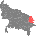
| JU | Jaunpur District Jaunpur District Jaunpur is a district in the Varanasi Division of Uttar Pradesh state in India. Jaunpur serves as the district headquarters.-Geography:The district of Jaunpur is situated in the North-West part of Varanasi Division. Its land area extends from 24.240N to 26.120N latitude and between 82.70E and... |
Jaunpur Jaunpur, Uttar Pradesh Jaunpur is a city and a municipal board in Jaunpur district in the Indian state of Uttar Pradesh.Jaunpur district is located to the northwest of the district of Varanasi in the eastern part of the North Indian state of Uttar Pradesh. According to the 2001 census, Jaunpur district had a population... |
3,911,305 | 4,038 | 969 | |||
| KD | Kanpur Dehat | Akbarpur | 1,584,037 | 3,143 | 504 | |||
| KJ | Kannauj Kannauj District Kannauj District is an administrative district of Uttar Pradesh state in northern India, along the river Ganges. The historic town of Kannauj, northwest of Kanpur, is the administrative center.-Geography:... |
Kannauj Kannauj Kannauj , also spelt Kanauj, is a city, administrative headquarters and a municipal board or Nagar Palika Parishad in Kannauj district in the Indian state of Uttar Pradesh. The city's name is traditionally derived from the term Kanyakubja . Kannauj is an ancient city, in earlier times the capital... |
1,385,227 | 1,993 | 695 | |||
| KN | Kanpur Nagar | Kanpur | 4,137,489 | 3,029 | 1,366 | |||
| - | Kanshi Ram Nagar Kanshi Ram Nagar Kanshi Ram Nagar is 71st district of Uttar Pradesh, India. It is located in the division of Aligarh and consists of Kasganj, Patiali and Sahawar tehsils. Its headquarters is at Kasganj. Mr... |
Kasganj Kasganj Kasganj is a city and a district headquarters of Kanshi Ram Nagar district in the Indian state of Uttar Pradesh.-Geography:Kasganj is located at . It has an average elevation of 177 metres . Situated on the banks of river Kali, the town is in proximity of the Himalayas foothills... |
- | - | – | – | ||
| KS | Kaushambi Kaushambi District Kaushambi district is one of the districts of Uttar Pradesh state of India, and Manjhanpur town is the district headquarters. Kaushambi district is a part of Allahabad Division.- History :... |
Manjhanpur Manjhanpur Manjhanpur is a town, nagar panchayat and district headquarter of Kaushambi district in the Indian state of Uttar Pradesh.-Demographics: India census, Manjhanpur had a population of 14,150. Males constitute 53% of the population and females 47%. Manjhanpur has an average literacy rate of 55%,... |
1,294,937 | 1,837 | 705 | |||
| KU | Kushinagar Kushinagar District Kushinagar District is a district of Uttar Pradesh state in northern India. Padarauna is the district headquarters. The district is named for Kushinagar, a Buddhist pilgrimage site where Gautama Buddha attained parinirvana in the 6th or 5th centuries BCE.... |
Padarauna | 2,891,933 | 2,909 | 994 | |||
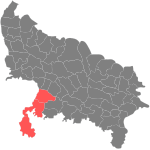
| LA | Lalitpur Lalitpur District, Uttar Pradesh Lalitpur District is one of the districts of Uttar Pradesh state of India. Lalitpur district is a part of Jhansi Division. Lalitpur is the main town and administrative headquarters. The district occupies an area of 5,039 km².... |
Lalitpur Lalitpur, India Lalitpur is a city and a municipal board in Lalitpur district in the Indian state of Uttar Pradesh. It is also district headquarters of Lalitpur district.-Demographics:... |
977,447 | 5,039 | 194 | |||
| LK | Lakhimpur Kheri Lakhimpur Kheri Lakhimpur Kheri is a district of Uttar Pradesh in the Lucknow division. It is located in India along the border with Nepal. The headquarters of the Lakhimpur Kheri District are situated in the city of Lakhimpur.... |
Kheri Kheri Kheri is a town and a nagar panchayat in Lakhimpur Kheri district in the Indian state of Uttar Pradesh.-Geography:Kheri is located at . It has an average elevation of 148 metres .-Demographics:... |
3,200,137 | 7,680 | 417 | |||
| LU | Lucknow Lucknow District Lucknow District is a district of Uttar Pradesh state in northern India. The city of Lucknow is the district headquarters and the district is part of Lucknow Division... |
Lucknow Lucknow Lucknow is the capital city of Uttar Pradesh in India. Lucknow is the administrative headquarters of Lucknow District and Lucknow Division.... |
3,681,416 | 2,528 | 1,456 | |||
| MB | Mau Mau district Mau district is one of the districts of Uttar Pradesh state of India and Mau town is the district headquarters. Mau district is a part of Azamgarh Division. Mau district is situated in the south-eastern part of the state with headquarters at Mau town... |
Mau Mau Mau , formerly Mau Nath Bhanjan , nearly 90 km from Varanasi is the powerhouse of textile weavers in Eastern UP, India. It is a small industrial town on the banks of Ghaghra . The Tamasa river flows through the city... |
1,849,294 | 1,713 | 1,080 | |||
| ME | Meerut Meerut District Meerut district , is one of the districts of Uttar Pradesh state of India, and Meerut is the district headquarters. Meerut district is a part of Meerut division.-Demographics:... |
Meerut | 3,001,636 | 2,522 | 1,190 | |||
| MG | Maharajganj Maharajganj District Maharajganj district is one of the 71 districts of Uttar Pradesh state in northern India, and the town of Maharajganj is the district headquarters.-Geography:... |
Maharajganj Maharajganj Maharajganj is a town and a notified area in Siwan district in the Indian state of Bihar.-Geography:Maharajganj is located at . It has an average elevation of 66 metres .-Demographics:... |
2,167,041 | 2,948 | 735 | |||
| MH | Mahoba Mahoba District Mahoba district is one of the districts of Uttar Pradesh state of India and Mahoba town is the district headquarters. Mahoba district is a part of Chitrakoot Division. The district occupies an area of 2884 km². It has a population of 708,447... |
Mahoba Mahoba Mahoba is a city and Mahoba District of the Indian state of Uttar Pradesh, in the Bundelkhand region. Mahoba is known for its closeness to Khajuraho, Laundi and other historic places like Kulpahar, Charkhari, Kalinjar, Orchha, and Jhansi... |
708,831 | 2,847 | 249 | |||
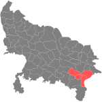
| MI | Mirzapur Mirzapur District Mirzapur district is one of the 70 districts of Uttar Pradesh state in northern India. The district is bounded on the north by Sant Ravidas Nagar and Varanasi districts, on the east by Chandauli district, on the south by Sonbhadra district and on the norhwest by Allahabad district. The district... |
Mirzapur Mirzapur Mirzapur is a city in the heart of North India, nearly 650 km between Delhi and Kolkata and also equidistant from Allahabad and Varanasi. Located in the state of Uttar Pradesh, Mirzapur has a population of a little over 205,264 and is renowned for its famous carpet and brassware industry... |
2,114,852 | 4,522 | 468 | |||
| MO | Moradabad Moradabad District Moradabad district is one of the districts of Uttar Pradesh state of India, and Moradabad town is the district headquarters. Moradabad district is a part of Moradabad division... |
Moradabad Moradabad Moradabad is a city and a municipal corporation in Moradabad district in the Indian state of Uttar Pradesh. It was established in 1600 by prince Murad, the son of the Mughal Emperor Shah Jahan; as a result the city came to be known as Moradabad. It is the administrative headquarters of... |
3,749,630 | 3,648 | 1,028 | |||
| MP | Mainpuri Mainpuri District Mainpuri district is one of the districts of Uttar Pradesh state of India, and Mainpuri town is the district headquarters. Mainpuri district is a part of Agra division.-Demographics:... |
Mainpuri Mainpuri Mainpuri is a city and a municipal board in Mainpuri district in the Indian state of Uttar Pradesh. It is the administrative headquarters of the Mainpuri district and is situated to the north-east of Agra.-Geography:... |
1,592,875 | 2,760 | 577 | |||
| MT | Mathura Mathura District Mathura District is a district of Uttar Pradesh state of northern India. The historic town of Mathura is the district headquarters.The district is bounded on the northeast by Aligarh District, on the southeast by Hathras District, on the south by Agra District, and on the west by Rajasthan and... |
Mathura | 2,069,578 | 3,333 | 621 | |||
| MU | Muzaffarnagar Muzaffarnagar District Muzaffarnagar district is a district of Uttar Pradesh state in northern India. It is part of Saharanpur division. The town of Muzaffarnagar is the district headquarters.-Communication:... |
Muzaffarnagar Muzaffarnagar Muzaffarnagar is a major city and a municipal board in the Indian state of Uttar Pradesh. The city was established in Mughal period by a Sayyid Jagirdar, Munawar Lashkar Ali, and so named in honour of his father, Muzaffar Ali Khan. It is the headquarters of the Muzaffarnagar district. It is a... |
3,541,952 | 4,008 | 884 | |||
| PI | Pilibhit Pilibhit District Pilibhit district is one of the districts in the state of Uttar Pradesh in India, and Pilibhit city is the district headquarters. Pilibhit district is a part of Bareilly Division.The city is famous for its contribution to Bollywood, Urdu literature and its involvement in Politics of India... |
Pilibhit Pilibhit Pilibhit |Hafizabad]]) is a city and a municipal board in the Pilibhit district in the Indian state of Uttar Pradesh. Pilibhit is the north-eastern most district of Bareilly division, situated in the Rohilkhand region of the sub-Himalayan Plateau belt on the boundary of Nepal, known for the origin... |
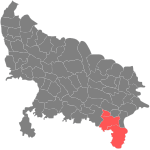
1,643,788 | 3,499 | 470 | 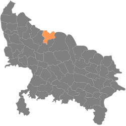 |
||
| PR | Pratapgarh | Pratapgarh | 2,727,156 | 3,717 | 734 | |||
| RA | Rampur Rampur District Rampur district is one of the districts of Uttar Pradesh state of India, and Rampur town is the district headquarters. Rampur district is a part of Moradabad division. The district occupies an area of 2,367 km²... |
Rampur Rampur, Uttar Pradesh Rampur is a city and a municipality located in Rampur District in the Indian state of Uttar Pradesh. Rampur district is located at Longitude 78-0-54 to 69-0-28 East and Latitude 28-25 to 29-10 North and spans an area of 2,367 km².It also gave its name to a former princely state of British... |
1,922,450 | 2,367 | 812 | |||
| RB | Rae Bareli | Rae Bareli | 2,872,204 | 4,609 | 623 | |||
| SA | Saharanpur Saharanpur District Saharanpur district is the northernmost of the districts of Uttar Pradesh state, India. Bordering the states of Haryana and Uttarakhand, and close to the foothills of Shivalik range, it lies in the northern part of the Doab region... |
Saharanpur Saharanpur Saharanpur is a city and a Municipal Corporation in the state of Uttar Pradesh in northern India. It is the administrative headquarters of Saharanpur District as well as Saharanpur Division... |
2,848,152 | 3,689 | 772 | |||
| SI | Sitapur Sitapur District Sitapur district is one of the districts of Uttar Pradesh state of India, with Sitapur town as the district headquarters. Sitapur district is a part of Lucknow division. This district covers an area of 5743 km². It has a population of 3,619,661.... |
Sitapur Sitapur Sitapur formerly spelled as Citapore is a town and a municipal board in Sitapur district in the state of Uttar Pradesh, India. It is in the Lucknow Division of Uttar Pradesh... |
3,616,510 | 5,743 | 630 | |||
| SJ | Shahjahanpur Shahjahanpur District Shahjahanpur district is one of the historical districts of Uttar Pradesh in the republic of India. It is a part of Bareilly division. The main town is Shahjahanpur and its Tehsils are: Powayan, Tilhar, Jalalabad, and Kanth.... |
Shahjahanpur Shahjahanpur Shahjahanpur is a municipal board, town and district headquarters of Shahjahanpur District in Uttar Pradesh, India.-History:During the reign of Shahjahan, Mughal forces demolished the city of Kant... |
2,549,458 | 4,575 | 557 | |||
| Shamli | Shamli Shamli Shamli is a city, tehsil and now a district headquarters in the Indian state of Uttar Pradesh. It is located on the Delhi - Saharanpur highway. It is around 100 km from Delhi, 38 km from Panipat and 65 km from Saharanpur... |
SK | Sant Kabir Nagar | Khalilabad | 1,424,500 | 1,442 | 988 | |
| SN | Siddharthnagar | Navgarh Navgarh Naugarh is the district headquarters of Siddharthnagar district in Uttar Pradesh, India... |
2,038,598 | 2,751 | 741 | |||
| SO | Sonbhadra Sonbhadra Sonbhadra or Sonebhadra is the 2nd largest district of Uttar Pradesh, India. The district has an area of 6788 km² and a population of 1,463,468 , with a population density of 216 persons per km²... |
Robertsganj Robertsganj Robertsganj is a city and a municipal board in Sonbhadra district in the Indian state of Uttar Pradesh. Located in the southeastern corner of the state. Robertsganj is the administrative headquarters of Sonbhadra District.- Geography :Robertsganj is located at... |
1,463,468 | 6,788 | 216 | |||
| SR | Sant Ravidas Nagar Sant Ravidas Nagar Sant Ravidas Nagar District -History:Sant Ravidas Nagar District was created on June 30, 1994 as 65th district of the state. The district is famous for its carpets in India and abroad.-Geography:... |
Gyanpur Gyanpur Gyanpur is a town and a nagar panchayat in Sant Ravidas Nagar district in the Indian state of Uttar Pradesh.-Geography:Gyanpur is located at . It has an average elevation of 81 metres .-Demographics:... |
1,352,056 | 960 | 1,408 | |||
| SU | Sultanpur Sultanpur District Sultanpur District is a district in the state of Uttar Pradesh in northern India. The district is a part of Faizabad Division. Its administrative head is Sultanpur.-History:... |
Sultanpur | 3,190,926 | 4,436 | 719 | |||
| SV | Shravasti Shravasti District Shravasti District is one of the districts of the Uttar Pradesh state of India and Bhinga town is district headquarter. Shravasti district is a part of Devipatan Division... |
Shravasti Shravasti District Shravasti District is one of the districts of the Uttar Pradesh state of India and Bhinga town is district headquarter. Shravasti district is a part of Devipatan Division... |
1,175,428 | 1,126 | 1,044 | |||
| UN | Unnao Unnao District Unnao District is a district of Uttar Pradesh state in northern India. The town of Unnao is the district headquarters. The district is part of Lucknow Division.-History:... |
Unnao Unnao The town of Unnao is the headquarters of Unnao District in Uttar Pradesh, India between Kanpur and Lucknow. It is approximately 18 km from Kanpur & 60 km from Lucknow . It is connected to these two cities by roadway as well as by railway. The nearest airport is at Amausi about... |
2,700,426 | 4,558 | 592 | |||
| VA | Varanasi Varanasi District Varanasi district is one of the districts of Uttar Pradesh state in northern India, with Varanasi city as the district headquarters. Varanasi district is a part of Varanasi division. The district occupies an area of 1,535 km². The district has a population of 3,138,671 .-Divisions:The... |
Varanasi Varanasi -Etymology:The name Varanasi has its origin possibly from the names of the two rivers Varuna and Assi, for the old city lies in the north shores of the Ganga bounded by its two tributaries, the Varuna and the Asi, with the Ganges being to its south... |
3,147,927 | 1,578 | 1,995 |
See also
- Divisions of Uttar PradeshDivisions of Uttar PradeshThe Indian state of Uttar Pradesh borders with Nepal and the Indian states of Bihar, Jharkhand, Chhattisgarh, Madhya Pradesh, Rajasthan, Haryana, Uttarakhand and National Capital Territory of Delhi. The Himalayas lies in the north of the state and the Deccan Plateau is at the south...
- List of RTO districts in Uttar Pradesh