
Distant Early Warning Line
Encyclopedia
Radar
Radar is an object-detection system which uses radio waves to determine the range, altitude, direction, or speed of objects. It can be used to detect aircraft, ships, spacecraft, guided missiles, motor vehicles, weather formations, and terrain. The radar dish or antenna transmits pulses of radio...
stations in the far northern Arctic
Arctic
The Arctic is a region located at the northern-most part of the Earth. The Arctic consists of the Arctic Ocean and parts of Canada, Russia, Greenland, the United States, Norway, Sweden, Finland, and Iceland. The Arctic region consists of a vast, ice-covered ocean, surrounded by treeless permafrost...
region of Canada
Canada
Canada is a North American country consisting of ten provinces and three territories. Located in the northern part of the continent, it extends from the Atlantic Ocean in the east to the Pacific Ocean in the west, and northward into the Arctic Ocean...
, with additional stations along the North Coast and Aleutian Islands of Alaska
Alaska
Alaska is the largest state in the United States by area. It is situated in the northwest extremity of the North American continent, with Canada to the east, the Arctic Ocean to the north, and the Pacific Ocean to the west and south, with Russia further west across the Bering Strait...
, in addition to the Faroe Islands
Faroe Islands
The Faroe Islands are an island group situated between the Norwegian Sea and the North Atlantic Ocean, approximately halfway between Scotland and Iceland. The Faroe Islands are a self-governing territory within the Kingdom of Denmark, along with Denmark proper and Greenland...
, Greenland
Greenland
Greenland is an autonomous country within the Kingdom of Denmark, located between the Arctic and Atlantic Oceans, east of the Canadian Arctic Archipelago. Though physiographically a part of the continent of North America, Greenland has been politically and culturally associated with Europe for...
, and Iceland
Iceland
Iceland , described as the Republic of Iceland, is a Nordic and European island country in the North Atlantic Ocean, on the Mid-Atlantic Ridge. Iceland also refers to the main island of the country, which contains almost all the population and almost all the land area. The country has a population...
. It was set up to detect incoming Soviet
Soviet Union
The Soviet Union , officially the Union of Soviet Socialist Republics , was a constitutionally socialist state that existed in Eurasia between 1922 and 1991....
bomber
Bomber
A bomber is a military aircraft designed to attack ground and sea targets, by dropping bombs on them, or – in recent years – by launching cruise missiles at them.-Classifications of bombers:...
s during the Cold War
Cold War
The Cold War was the continuing state from roughly 1946 to 1991 of political conflict, military tension, proxy wars, and economic competition between the Communist World—primarily the Soviet Union and its satellite states and allies—and the powers of the Western world, primarily the United States...
, and provide early warning of a land based invasion.
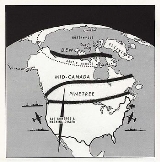
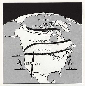
The DEW Line was the northernmost and most capable of three radar lines in Canada; the joint Canadian-US Pinetree Line
Pinetree Line
The Pinetree Line was a series of radar stations located across the northern United States and southern Canada at about the 50th parallel north, along with a number of other stations located on the Atlantic and Pacific coasts. Run by NORAD , over half were manned by United States Air Force...
ran from Newfoundland to Vancouver Island
Vancouver Island
Vancouver Island is a large island in British Columbia, Canada. It is one of several North American locations named after George Vancouver, the British Royal Navy officer who explored the Pacific Northwest coast of North America between 1791 and 1794...
, and the Mid-Canada Line
Mid-Canada Line
The Mid-Canada Line, also known as the McGill Fence, was a line of radar stations across the "middle" of Canada to provide early warning of a Soviet bomber attack on North America. It was built to supplement the less-advanced Pinetree Line, which was located further south...
ran somewhat north of this.
Introduction
The DEW Line was a significant achievement among Cold War initiatives in the Arctic. A successful combination of scientific design and logistical planning of the late 1950s, the DEW Line consisted of a string of continental defence radar installations, ultimately stretching from Alaska to Greenland. In addition to the secondary Mid-Canada LineMid-Canada Line
The Mid-Canada Line, also known as the McGill Fence, was a line of radar stations across the "middle" of Canada to provide early warning of a Soviet bomber attack on North America. It was built to supplement the less-advanced Pinetree Line, which was located further south...
and the tertiary Pinetree Line
Pinetree Line
The Pinetree Line was a series of radar stations located across the northern United States and southern Canada at about the 50th parallel north, along with a number of other stations located on the Atlantic and Pacific coasts. Run by NORAD , over half were manned by United States Air Force...
, the DEW Line marked the edge of an electronic grid controlled by the new SAGE (Semi Automatic Ground Environment
Semi Automatic Ground Environment
The Semi-Automatic Ground Environment was an automated control system for tracking and intercepting enemy bomber aircraft used by NORAD from the late 1950s into the 1980s...
) computer system and was ultimately centred on the Colorado command hub of the North American Aerospace Defense Command
North American Aerospace Defense Command
North American Aerospace Defense Command is a joint organization of Canada and the United States that provides aerospace warning, air sovereignty, and defense for the two countries. Headquarters NORAD is located at Peterson AFB, Colorado Springs, Colorado...
(NORAD).
The construction of the DEW Line was made possible by bilateral agreement between the Canadian and American governments and by an alliance between the U.S. Department of Defense and the Bell system of communication companies. It grew out of a detailed study made by a group of the nation's foremost scientists in 1952, the Summer Study Group at the Massachusetts Institute of Technology. The subject of the study was the vulnerability of the U.S. and Canada to air attack, and its concluding recommendation was that a distant early warning line of search radar stations be built across the Arctic border of the North American continent as rapidly as possible.
Development and construction
_line.jpg)
69th parallel north
The 69th parallel north is a circle of latitude that is 69 degrees north of the Earth's equatorial plane, in the Arctic. It crosses the Atlantic Ocean, Europe, Asia and North America, and passes through some of the southern seas of the Arctic Ocean....
, 200 miles or 300 kilometers north of the Arctic Circle
Arctic Circle
The Arctic Circle is one of the five major circles of latitude that mark maps of the Earth. For Epoch 2011, it is the parallel of latitude that runs north of the Equator....
.
Before the job was completed, men with the necessary knowledge, skills and experience were drawn from Bell telephone companies in every state in the U.S. Much of the responsibility was delegated under close supervision to a vast number of subcontractors, suppliers, and U.S. military units.
The initial contract with the Air Force provided for the design and construction of a small experimental system to determine at the beginning whether the idea was practicable. The designs of communication and radar detection equipment available at the time were known to be unsuited to the weather and atmospheric conditions encountered in the Arctic. Prototypes of several stations were designed and built in Alaska and in a rural section of Illinois in 1953. While few of the original designs for either buildings or equipment were retained, the trial installations did prove that the DEW Line was feasible, and furnished a background of information that led to the final improved designs of all facilities and final plans for manpower, transportation and supply.
With the experimental phase completed successfully, the Air Force asked Western Electric to proceed as rapidly as possible with the construction of the entire DEW Line. This was in December 1954, before the route to be followed in the eastern section had even been determined. The locations were surveyed out by John Anderson-Thompson
John Anderson-Thompson
John Anderson-Thomson was born in Glengairn, Scotland and enlisted in the Royal Flying Corps. at 16 during World War I. In 1920, he came to Canada, working as a sheep farmer in Saskatchewan. In 1926, Anderson-Thomson returned to Scotland, meeting and marrying Janet Grant of Braemer Village...
Siting crews covered the area - first from the air and then on the ground - to locate by scientific means the best sites for the main, auxiliary and intermediate stations. These hardy men lived and worked under the most primitive conditions. They covered vast distances by plane, snowmobile and dog sled, working in blinding snowstorms with temperatures so low that ordinary thermometers could not measure them. But they completed their part of the job on schedule and set the stage for the small army of men and machines that followed. The line consisted of 63 stations stretching from Alaska
Alaska
Alaska is the largest state in the United States by area. It is situated in the northwest extremity of the North American continent, with Canada to the east, the Arctic Ocean to the north, and the Pacific Ocean to the west and south, with Russia further west across the Bering Strait...
to Baffin Island
Baffin Island
Baffin Island in the Canadian territory of Nunavut is the largest island in the Canadian Arctic Archipelago, the largest island in Canada and the fifth largest island in the world. Its area is and its population is about 11,000...
, covering almost 10,000 km. The United States agreed to pay for and construct the line, and employ Canadian labour as much as possible.
A target date for completing the Line and having it in operation was set for July 31, 1957. This provided only two short Arctic summers totaling about six months in which to work under passable conditions. The bulk of the work would have to be completed in the long, dark, cold Arctic winters.
From a standing start in December 1954, many thousands of people with countless skills were recruited, transported to the polar regions, housed, fed, and supplied with tools, machines and materials in order to construct physical facilities—buildings, roads, tanks, towers, antennas, airfields and hangars—at some of the most isolated spots in North America. The construction project employed more than 25,000 people.
Military and civilian airlifts, huge sealifts during the short summers, cat
Snowcat
A snowcat is an enclosed-cab, truck sized, fully tracked vehicle designed to move on snow. Snowcats are often referred to as 'trail groomers' because of their use for grooming ski trails or snowmobile trails...
trains and barges distributed vast cargoes the length of the Line to build the permanent settlements needed at each site. To military and naval units fell much of the job of transporting mountains of supplies to the northern sites. More than 3,000 Army Transportation Corps soldiers were given special training to prepare them for the job of unloading ships in the Arctic. They accompanied the convoys provided by the U.S. Navy and raced time during the few weeks the ice was open to land supplies at dozens of spots on the Arctic Ocean shore during the summers of 1955, 1956 and 1957.
Scores of commercial pilots, flying everything from bush planes to four-engine ships, were the backbone of one of the greatest airlift operations in history. Helping them were U.S. Air Force crews of the “C-124 Globemasters” and “C-119 Flying Boxcar
C-119 Flying Boxcar
The Fairchild C-119 Flying Boxcar was an American military transport aircraft developed from the World War II-era Fairchild C-82 Packet, designed to carry cargo, personnel, litter patients, and mechanized equipment, and to drop cargo and troops by parachute...
s.” Together they provided the only means of access to many of the stations during the winter. In all, 460,000 tons of materials were moved from the U.S. and Canada to the Arctic by air, land and water.
As the stacks of materials at the station sites mounted, construction went ahead rapidly. Subcontractors with a flair for tackling difficult construction projects handled the bulk of this work under Western Electric direction. Prodigious quantities of gravel were produced and moved. Construction work needed to build housing, air strips, hangars, antennas and towers was done by subcontractors. In all, over 7,000 bulldozer operators, carpenters, masons, plumbers, welders, riggers, electricians and other tradesmen from the U.S. and Canada worked at breakneck speed under conditions so difficult it is a wonder the job was completed in such a short time. Concrete was poured in the middle of the Arctic winters, buildings were constructed, electricity, heat and water provided, huge steel antenna towers were erected, airstrips and hangars were built and putting it all together in darkness, blizzards and sub-zero cold.
After the building came the installation of radar and communications equipment; then the thorough and time-consuming testing of each unit individually and of the system as an integrated whole. Finally all was ready, and on 15 April 1957 - just two years and eight months after the decision to build the Distant Early Warning Line was made - Western Electric turned over to the Air Force on schedule a complete, operating radar system across the top of North America, with its own complete communications network.
The majority of Canadian DEW Line stations were the joint responsibility of the Royal Canadian Air Force
Royal Canadian Air Force
The history of the Royal Canadian Air Force begins in 1920, when the air force was created as the Canadian Air Force . In 1924 the CAF was renamed the Royal Canadian Air Force and granted royal sanction by King George V. The RCAF existed as an independent service until 1968...
(Canadian Forces
Canadian Forces
The Canadian Forces , officially the Canadian Armed Forces , are the unified armed forces of Canada, as constituted by the National Defence Act, which states: "The Canadian Forces are the armed forces of Her Majesty raised by Canada and consist of one Service called the Canadian Armed Forces."...
) and the U.S. Air Force
United States Air Force
The United States Air Force is the aerial warfare service branch of the United States Armed Forces and one of the American uniformed services. Initially part of the United States Army, the USAF was formed as a separate branch of the military on September 18, 1947 under the National Security Act of...
. The USAF component was the 64th Air Division, Air Defense Command. The 4601st Support Squadron, Paramus, New Jersey, was activated by ADC to provide logistical and contractual support for Dew Line operations. In 1958, the line became a cornerstone of the new NORAD organization of joint continental air defence.
USAF military personnel were limited to the Main stations for each sector and performed annual inspections of Auxiliary and Intermediate stations as part of the contract administration; most operations were performed by Canadian and United States contract personnel. All of the installations flew both Canadian and United States flags until they were inactivated as DEW sites, and jurisdiction was transferred to the Canadian Government as part of the North Warning System in the late 1980s and early 1990s.
Radar system
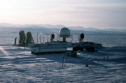
In Point Lay, AlaskaPoint Lay, Alaska
Point Lay is a census-designated place in North Slope Borough, Alaska, United States. At the 2000 census the population was 247.-Geography:Point Lay is located at on the shores of the Chukchi Sea....
, the main AN/FPS-19 search radar is in the dome, flanked by two AN/FRC-45 lateral communications dishes (or AN/FRC-102, depending on the date). To the left are the much larger southbound AN/FRC-101 communications dishes. Not visible is the AN/FPS-23 "gap filler" Doppler antenna.
The DEW Line was upgraded with fifteen new AN/FPS-117
AN/FPS-117
The AN/FPS-117 is a phased array, 3-dimensional air search radar. It is produced by the Lockheed Martin corporation from the United States.The system is a low power, long range , L-band pencil beam, solid-state transmitter and beacon interrogator search radar...
phased-array radars between 1985 and 1994, and re-named the North Warning System
North Warning System
The North Warning System is a joint United States and Canadian radar system for the atmospheric air defense of North America. It provides surveillance of airspace from potential incursions or attacks from across North America's polar region...
.
Operating Characteristics of the An/TPS-1D (Mod c) Search Radar
Frequency Range 1220-1350 MHz
Peak Power Output 160kw
Average Power Output -400W
Pulse Rate 400 pulses/per second
Pulse Width 6.0usec
Range 1000 yard to 160 nmi
Antenna Radiation Pattern
Horizontal 2.8 degrees
Vertical cosecant (elevation single)
Receiver Noise Figure 11.7 db
IF Bandwith and Frequency 5MHz at 60 MHz
Required Prime Power 8.5 KW
Approximate Weight of Radar 4800 lb
Total Volume 1000ft to the third
Modifications to each operating radar station occurred during the construction phase of the DEW Line system. This was due to the extreme winds, frigid temperatures, and the ground conditions due to permafrost and ice. There were two significant electronic modifications that were also crucial to the functionality of these radar stations within a northern environment. One reduced the effects of vibration in corolation to temperature change, the other increased the pulse rate for 2 to 6 usec and began utilizing a crystal oscillator for more stable readings and accurate accounts of movement within the air.
Operations
.jpg)
There were three types of stations: small unmanned "gap fillers" that were checked by aircrews only every few months during the summer; intermediate stations with only a station chief, a cook, and a mechanic; and larger stations that had a variable number of employees and may have had libraries, movie projectors, and other accommodations. The stations used a number of long-range pulse radar systems known as AN/FPS-19
AN/FPS-19
The Raytheon AN/FPS-19 was developed for the Distant Early Warning Line as its primary long-range search radar.-References:*...
. The "gaps" between the stations were watched by the directional AN/FPS-23
AN/FPS-23
The Motorola AN/FPS-23 was a short-range search radar deployed to the Distant Early Warning Line "Intermediate" sites as gap fillers between the long-range AN/FPS-19 Main and Auxiliary stations. It was declared obsolete in 1963, and the Intermediate stations were closed.-References:*...
Doppler radar
Doppler radar
A Doppler radar is a specialized radar that makes use of the Doppler effect to produce velocity data about objects at a distance. It does this by beaming a microwave signal towards a desired target and listening for its reflection, then analyzing how the frequency of the returned signal has been...
systems, similar to those pioneered only a few years earlier on the Mid-Canada Line. The stations were interconnected by a series of radio communications systems utilizing tropospheric scatter
Tropospheric scatter
Tropospheric scatter is a method of transmitting and receiving microwave radio signals over considerable distances – often up to 300 km...
technology.
Like any well-planned community in the U.S., each main station had its own electricity, water service, heating facilities, homes, work buildings, recreation areas and roads. But there the similarity ended. The Arctic dictated what the buildings looked like, how they were built and even in what direction they faced. Instead of a group of separate buildings, the typical main station was essentially two long, low buildings connected by an enclosed overhead bridge, forming the letter “H.” At one end, set on steel stilts, was the radome - a weather-tight dome covering the radar antenna. Nearby were the huge “reflectors” that provided radio communication with the outside world. Living quarters, recreation facilities, radar and radio equipment and power and heating plants were are all within the main buildings.
For stations at the western end of the line, buildings at a deactivated Navy camp at Point Barrow were converted into workshops where prefabricated panels, fully insulated, were put together to form modular building units 28 feet long, 16 feet wide and 10 feet high. These modules were put on sleds and drawn to station sites hundreds of miles away by powerful tractors. Each main station has its own airstrip - as close to the buildings as safety regulations and the terrain permit. Service buildings, garages, connecting roads, storage tanks and perhaps an aircraft hangar completed the community. Drifting snow was a constant menace. Siting engineers and advance parties learned this the hard way when their tents disappeared beneath the snow in a few hours. The permanent “H” shaped buildings at the main stations were always pointed into the prevailing winds and their bridges built high off the ground.
The Early Warning provided was useless against ICBMs and submarine
Submarine
A submarine is a watercraft capable of independent operation below the surface of the water. It differs from a submersible, which has more limited underwater capability...
-launched attacks (which would not occur from an Arctic launch platform in any case). These were countered and tempered by the MAD
Mutual assured destruction
Mutual Assured Destruction, or mutually assured destruction , is a doctrine of military strategy and national security policy in which a full-scale use of high-yield weapons of mass destruction by two opposing sides would effectively result in the complete, utter and irrevocable annihilation of...
(Mutually Assured Destruction) philosophy. However, the scenario of a coordinated airborne invasion coupled with a limited nuclear strike was the real threat that this line protected against. It did this by providing Distant Early Warning of an inbound invasion force, which would have to appear at the far north hours ahead of any warhead launches in order to be coordinated well enough to prevent MAD. A number of intermediate stations were decommissioned, since their effectiveness was judged to be less than desired and required. The manned stations were retained to monitor potential Soviet air activities and to allow Canada to assert sovereignty
Sovereignty
Sovereignty is the quality of having supreme, independent authority over a geographic area, such as a territory. It can be found in a power to rule and make law that rests on a political fact for which no purely legal explanation can be provided...
in the Arctic
Arctic
The Arctic is a region located at the northern-most part of the Earth. The Arctic consists of the Arctic Ocean and parts of Canada, Russia, Greenland, the United States, Norway, Sweden, Finland, and Iceland. The Arctic region consists of a vast, ice-covered ocean, surrounded by treeless permafrost...
. International law requires a country that claims territory to actively occupy and defend such territory.
Because the advent of ICBMs created another attack scenario that the DEW Line could not defend against, in 1958 the US Government authorized construction of the Ballistic Missile Early Warning System (BMEWS), at a reported cost of $28 billion.
In 1985, it was decided that the more capable of the DEW Line stations were to be upgraded with the GE AN/FPS 117 radar systems and merged with newly-built stations into the North Warning System
North Warning System
The North Warning System is a joint United States and Canadian radar system for the atmospheric air defense of North America. It provides surveillance of airspace from potential incursions or attacks from across North America's polar region...
. Automation was increased and a number of additional stations were closed. This upgrade was completed in 1990, and with the end of the Cold War
Cold War
The Cold War was the continuing state from roughly 1946 to 1991 of political conflict, military tension, proxy wars, and economic competition between the Communist World—primarily the Soviet Union and its satellite states and allies—and the powers of the Western world, primarily the United States...
and dissolution of the Soviet Union
Dissolution of the Soviet Union
The dissolution of the Soviet Union was the disintegration of the federal political structures and central government of the Union of Soviet Socialist Republics , resulting in the independence of all fifteen republics of the Soviet Union between March 11, 1990 and December 25, 1991...
, the United States withdrew all their personnel and turned over full operation of the Canadian stations to the Canadian military. Costs for the Canadian sector were still subsidized by the US, however; the US flag was lowered (without ceremony) at the Canadian stations and only the Canadian flag remained. The US retained responsibility and all operational costs for NWS Stations
North Warning System
The North Warning System is a joint United States and Canadian radar system for the atmospheric air defense of North America. It provides surveillance of airspace from potential incursions or attacks from across North America's polar region...
located in Alaska and Greenland.
Perception of the DEW Line
From the beginning of the DEW Line idea and development Canadian concerns over political perception grew enormously. Arctic historians all agree that there was a perception problem for the Canadian Government over the DEW Line. It began as early as 1949 and has been noted by the famous Canadian Arctic historian P. Whitney Lackenbauer that the Canadian Government saw little intrinsic value in the Arctic, but due to fear of Americanization and American penetration into the Canadian Arctic brought significant changes and a more militaristic role to the north. This shift into a more military role began with a change in the guard. Before the DEW Line system was installed the RCMP managed Arctic defense, the DEW Line system would bring would create a new role for the Canadian Military in defending Arctic sovereignty. This notion is often referred to as active over passive defense. Whitney would coin the term and would outline three key elements to active defense brought about due to the DEW Line system.1)Minimize the extent of U.S. Presence in the Arctic
2)Canadian Government consent in the DEW Line project and how it is managed
3)Full Canadian participation in DEW Line and Arctic defense
Funding problems for the DEW Line would also play a determining factor in perception of the project. Once American aid towards building and operating the DEW Line system declined, there was a need for Canada to step up to fill the void. In 1968 this void was not filled as outlined in the Department of National Defence Paper (November 27,1968) stated no further funding for research on the DEW Line or air space defense will be allocated due in part to lack of commercial activity The Canadian Government also would limit U.S. air activity, base activity, soldier numbers, contractor numbers, and the overall operation would be considered and called in all formalities a "joint operation".
Cultural Impact of DEW Line System
The cultural impact of the DEW Line System is immense and significant to the heritage of Canada. The three key elements to the impact on Canada's culture are1)Connection of North and South Canada
2)Economic Development of Arctic
3)Protection of DEW Line Sites
1) During the Cold War the social impact of the DEW Line system had not been thought of, or accounted for. Yet important connections between the south of Canada and the north of Canada became apparent. There is an important shared knowledge of place it represents a changing in the thinking of southern Canadians along with the desires and aspirations of northern inuit. Figuring out values from the DEW Line allows for the heritage and protection of said values.
2) The construction and operating of the DEW Line provided some economic development for the Arctic region. This provided a movement for further development through research, new communications, and new studies of the area. Unfortunately the construction of the DEW line itself was placed in American hands, much of the later development was under direct Canadian direction.
3) Protection of the DEW Line has been an important topic of discussion lately. The discussion streams froom the deactivation aspect of the sites and what to do with the leftover equipment and leftover sites that are still intact. There is a great drive currently by Canadian historians to preserve the legacy of the DEW Line through heritage designation, as a Cold War site. Further research into this discussion is needed.
Deactivation and clean-up
A controversy also developed between the United States and Canada over the cleanup of deactivated Canadian DEW Line sites. The stations had produced large amounts of hazardous waste that had been abandoned in the high Arctic. Especially damaging were the large quantities of PCBPolychlorinated biphenyl
Polychlorinated biphenyls are a class of organic compounds with 2 to 10 chlorine atoms attached to biphenyl, which is a molecule composed of two benzene rings. The chemical formula for PCBs is C12H10-xClx...
s. While the United States insisted that it was Canada's responsibility to clean up the sites they had managed, the Canadian government disagreed. In 1996, an agreement was reached that saw the United States contribute $100 million to the estimated $600 million cleanup effort. The cleanup is now underway, site by site. In assessing the clean up new research suggests that off road vehicles damaged vegetation and organic matter, resulting in the melting of the permafrost, a key component to the hydrological systems of the areas. The DEW Line has also been linked to depleting fish stocks, pilot carelessness in agitating local animals such as the caribou, non-seasonal hunting, has had a devastating impact on the local native subsistence economies and environment. Should the remaining sites become a part of the ministry of heritage designated sites within Canada? This is a debate that continues today however, more environmental assessment must be done and discussion with natives in the area need to take place.
Atlantic and Pacific Barrier
The DEW line was supplemented by two "barrier" forces in the Atlantic and the Pacific Oceans which were operated by the United States NavyUnited States Navy
The United States Navy is the naval warfare service branch of the United States Armed Forces and one of the seven uniformed services of the United States. The U.S. Navy is the largest in the world; its battle fleet tonnage is greater than that of the next 13 largest navies combined. The U.S...
from 1956 to 1965. These barrier forces consisted of surface picket stations, dubbed "Texas Towers
Texas Towers
The Texas Towers were a set of off-shore radar facilities used by the United States Air Force during the Cold War that were modeled on the offshore oil drilling platforms first employed off the Texas coast...
", each supported by radar destroyer escorts
Destroyer escort
A destroyer escort is the classification for a smaller, lightly armed warship designed to be used to escort convoys of merchant marine ships, primarily of the United States Merchant Marine in World War II. It is employed primarily for anti-submarine warfare, but also provides some protection...
, and an air wing of Lockheed WV-2 Warning Star
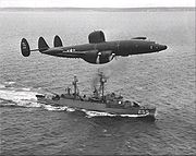
EC-121 Warning Star
The Lockheed EC-121 Warning Star was a United States Navy and United States Air Force airborne early warning radar surveillance aircraft. A military version of the Lockheed Constellation, it was designed to serve as an airborne early warning system to supplement the Distant Early Warning Line,...
aircraft that patrolled the picket lines at 1,000-2,000 m (3,000-6,000 ft) altitude in 12- to 14-hour missions. Their objective was to extend early warning coverage against surprise Soviet bomber and missile attack as an extension of the DEW Line.
Naval Station Argentia
Naval Station Argentia is a former base of the United States Navy that operated from 1941-1994. It was established in the community of Argentia in what was then the Dominion of Newfoundland, which later became the tenth Canadian province .-Construction:Established under the British-U.S...
, Newfoundland
Newfoundland and Labrador
Newfoundland and Labrador is the easternmost province of Canada. Situated in the country's Atlantic region, it incorporates the island of Newfoundland and mainland Labrador with a combined area of . As of April 2011, the province's estimated population is 508,400...
, to fly orbits to the Azores
Azores
The Archipelago of the Azores is composed of nine volcanic islands situated in the middle of the North Atlantic Ocean, and is located about west from Lisbon and about east from the east coast of North America. The islands, and their economic exclusion zone, form the Autonomous Region of the...
and back; and the other training at NAS Patuxent River, Maryland. BarLant began operations on 1 July 1956, and flew continuous coverage until early 1965, when the barrier was shifted to cover the approaches between Greenland
Greenland
Greenland is an autonomous country within the Kingdom of Denmark, located between the Arctic and Atlantic Oceans, east of the Canadian Arctic Archipelago. Though physiographically a part of the continent of North America, Greenland has been politically and culturally associated with Europe for...
, Iceland
Iceland
Iceland , described as the Republic of Iceland, is a Nordic and European island country in the North Atlantic Ocean, on the Mid-Atlantic Ridge. Iceland also refers to the main island of the country, which contains almost all the population and almost all the land area. The country has a population...
, and the United Kingdom
United Kingdom
The United Kingdom of Great Britain and Northern IrelandIn the United Kingdom and Dependencies, other languages have been officially recognised as legitimate autochthonous languages under the European Charter for Regional or Minority Languages...
(GIUK barrier
GIUK gap
The GIUK gap is an area in the northern Atlantic Ocean that forms a naval warfare chokepoint. Its name is an acronym for Greenland, Iceland, and the United Kingdom, the gap being the open ocean between these three landmasses...
). Aircraft from Argentia were staged through NAS Keflavik, Iceland
Iceland
Iceland , described as the Republic of Iceland, is a Nordic and European island country in the North Atlantic Ocean, on the Mid-Atlantic Ridge. Iceland also refers to the main island of the country, which contains almost all the population and almost all the land area. The country has a population...
, to extend coverage times.
The Pacific Barrier (BarPac) began operations with one squadron operating from NAS Barbers Point
Kalaeloa Airport
Kalaeloa Airport , also called John Rodgers Field and formerly Naval Air Station Barbers Point, is a joint civil-military regional airport of the State of Hawaii established on July 1, 1999 to replace the Ford Island NALF facilities which closed on June 30 of the same year...
, Hawaii
Hawaii
Hawaii is the newest of the 50 U.S. states , and is the only U.S. state made up entirely of islands. It is the northernmost island group in Polynesia, occupying most of an archipelago in the central Pacific Ocean, southwest of the continental United States, southeast of Japan, and northeast of...
, and a forward refueling base at Naval Station Midway
Midway Atoll
Midway Atoll is a atoll in the North Pacific Ocean, near the northwestern end of the Hawaiian archipelago, about one-third of the way between Honolulu, Hawaii, and Tokyo, Japan. Unique among the Hawaiian islands, Midway observes UTC-11 , eleven hours behind Coordinated Universal Time and one hour...
, on 1 July 1958. Its orbits overlapped the radar picket stations of the ships of Escort Squadron Seven (CORTRON SEVEN), from roughly Kodiak Island
Kodiak Island
Kodiak Island is a large island on the south coast of the U.S. state of Alaska, separated from the Alaska mainland by the Shelikof Strait. The largest island in the Kodiak Archipelago, Kodiak Island is the second largest island in the United States and the 80th largest island in the world, with an...
to Midway
Midway Atoll
Midway Atoll is a atoll in the North Pacific Ocean, near the northwestern end of the Hawaiian archipelago, about one-third of the way between Honolulu, Hawaii, and Tokyo, Japan. Unique among the Hawaiian islands, Midway observes UTC-11 , eleven hours behind Coordinated Universal Time and one hour...
. Normally 4 or 5 WV-2s were required at any single time to provide coverage over the entire line.
Barrier Force operations were discontinued by September 1965 and their EC-121K (WV-2 before 1962) aircraft placed in storage.
See also
- List of DEW Line Sites
- List of Royal Canadian Air Force stations
- List of Canadian Forces basesCanadian Forces baseA Canadian Forces Base or CFB is a military installation of the Canadian Forces. For a facility to qualify as a Canadian Forces Base, it must station one or more major units .Minor installations are named Canadian Forces Station or CFS A Canadian Forces Base or CFB (French Base des forces...
- Ballistic Missile Early Warning SystemBallistic Missile Early Warning SystemThe United States Air Force Ballistic Missile Early Warning System was the first operational ballistic missile detection radar. The original system was built in 1959 and could provide long-range warning of a ballistic missile attack over the polar region of the Northern Hemisphere. They also...
- White Alice Communications SystemWhite Alice Communications SystemThe White Alice Communications System was a United States Air Force telecommunication link system constructed in Alaska during the cold war. It featured tropospheric scatter links and line-of-sight microwave radio links...
- North Warning SystemNorth Warning SystemThe North Warning System is a joint United States and Canadian radar system for the atmospheric air defense of North America. It provides surveillance of airspace from potential incursions or attacks from across North America's polar region...
External links
- DEW Line Story (28 minute film from 1958)
- The DEW Line sites in Canada, Alaska and Greenland
- Online Archive of BAR-1 DEW Line Station by Parks Canada Arctic Historian David Neufeld
- Surveying for the installation of the DEW Line in 1955
- DEW Line in Cambridge Bay
- yourYukon: Cleaning up the DEW Line
- Canadian content - dew line doo doo?
- FactsCanada - Feature
- Defence Construction Canada
- Troposcatter communication network maps
- 1954 Distant Early Warning Line NWT Historical Timeline, Prince of Wales Northern Heritage Centre