
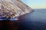
Diomede, Alaska
Encyclopedia
Diomede is a city in the Nome Census Area
of the Unorganized Borough of the U.S. state of Alaska
, located on Little Diomede Island
(native name Ignaluk; formerly known as Krusenstern Island which can also refer to other places
however). Little Diomede is the smaller of the two Diomede Islands
located in the middle of the Bering Strait
between the Alaska mainland and the Russian Far East
. Its neighboring island Big Diomede
, Russia behind the International Date Line
is less than 2.4 miles (3.9 km) away. Diomede lies on the west side of Little Diomede and is the only settlement on the island. The population was 146 at the 2000 census.
 According to the United States Census Bureau
, the village has a total area of 2.84 square miles (7.4 km²), all of it land.
Little Diomede Island is located about 25 miles (40.2 km) west from the mainland, in the middle of the Bering Strait
. It is only 0.6 mile (0.965604 km) from the International Date Line
and about 2.4 miles (3.9 km) from the Russian island of Big Diomede
. The highest point in Little Diomede Island is 919 feet (280.1 m).
type mountain and remains from the Bering land bridge
(also known as Beringia). The location of the city is the only area which does not have near-vertical cliffs to the water. Behind the city and around the entire island rocky slopes rise at about 40°
up to the relatively flattened top in 1148–1191 ft (349.9–363 m). The island has very scant vegetation.
s at Diomede had an advanced culture including their elaborate whale hunting ceremonies. Trading was made with both continents.
was a Russian explorer Semyon Dezhnev
in 1648. But it was a Danish navigator Vitus Bering
who re-discovered the islands on August 16, 1728, and named the islands after martyr St. Diomede who was celebrated in Russian Orthodox Church
on that date.
The United States purchased Alaska
from Russia in 1867 which included the Little Diomede. The new boundary was drawn between the two Diomede Islands and the Big Diomede
was left to Russia.
, on his visit to Diomede Islands in 1880s they found the natives eager to trade away everything they had. The village was perched on the steep rocky slope of the mountain which drops at once sheer into deep water. The huts were mostly built of stone with skin roofs. They looked like mere stoneheaps, black dots on the snow at a distance, with whalebone posts set up and framed at the top to lay their canoes beyond the dogs that would otherwise eat them.
During the Nome
gold rush
at the turn of the 19th century, Diomede villagers traveled to Nome along with the gold seekers, even though Nome was not a native village. People from Diomede arrived in Umiak
s and stayed in Nome for the summer, trading and gathering items before they returned to their isolated village.
s, tomcods
, bluecods
and a few others, although the fishing was not so common. During the winter time they used fur parkas and skin mukluk
s made out of hunted animals to protect themselves from cold and wind. Recreations were skating
, snowshoeing, hand ball, football and Eskimo dancing. After dark, people spent the rest of the evening telling jokes and old-time stories. In summer time they travelled with skin boats equipped with outboard motors to either Siberia
or Wales, Alaska
. Winter travel was limited to neighboring Big Diomede due to weather conditions. Between July and October half the population went to Nome for selling their carving and skin sewing and trading for supplies.
Despite being separated by the new border after the Alaska purchase
in 1867, Big Diomede
had been home to families now living on Little Diomede and the people living on the American side of the border were very close relatives to those living on the Russian side. The communities on both islands were separated by politics, but connected by family kinships. Despite being officially forbidden, the Eskimos from both islands occasionally visited their neighbors, sometimes under the cover of fog, to meet their relatives and exchange small gifts. The local schoolteachers on Little Diomede counted that 178 people from Big Diomede and the Siberian mainland visited the island only within 6 months between January and July in 1944.
At the beginning of the Cold War
in the late 1940s Big Diomede became a Russian military base
and all its native residents were removed to mainland Russia. When people from Little Diomede went too close to the Russian side or tried to visit their relatives on the neighboring island during World War II, they were taken captive. According to one of the survivors, Oscar Ahkinga, after 52 days of internment and interrogation, the Eskimos were banished and told not to come back.
migration started in the Spring. The annual walrus hunt meant major supply and income possibilities for the villagers, and everybody's help was needed. The primary language at the time was Inupiat, and students were also taught English. The only way of communication with the outside world was by amateur radio
. The non-existing health care
was somewhat upgraded with a basic medication
knowledge by seasonal teachers.
and they wanted to be hospitable and generous hosts, but many of the residents of Little Diomede never saw their relatives again.
of 2000, there were 146 people, 43 households, and 31 families residing in the city. The average population density
was 51.4 people per square mile (19.8/km²) though it is actually much higher within the small village where everyone lives. There were 47 housing units at an average density of 16.5 per square mile (6.4/km²). The racial makeup of the city was 92.47% Native American
, 6.16% White
and 1.37% from two or more races.
There were 43 households out of which 37.2% had children under the age of 18 living with them, 20.9% were married couples living together, 32.6% had a female householder with no husband present, and 27.9% were non-families. 18.6% of all households were made up of individuals and none had someone living alone who was 65 years of age or older. The average household size was 3.40 and the average family size was 4.00.
In the city the age distribution of the population shows 43.8% under the age of 18, 7.5% from 18 to 24, 25.3% from 25 to 44, 17.1% from 45 to 64, and 6.2% who were 65 years of age or older. The median age was 22 years. For every 100 females there were 114.7 males. For every 100 females age 18 and over, there were 121.6 males.
The median income for a household in the city was $23,750, and the median income for a family was $24,583. Males had a median income of $41,250 versus $26,875 for females. The per capita income
for the city was $29,944. There were 41.4% of families and 35.4% of the population living below the poverty line, including 33.8% of under eighteens and 44.4% of those over 64.
The first square building in the island was a small Catholic church, which was planned by Father Bellarmine Lafortune in 1935 and built by Father Thomas Cunningham during his residency in the island between 1936 and 1947. It was built from donated lumber from Nome
. The next square building in the island was a one-room school house, which also served as a home for the teacher's family. A new larger church building built by Father Thomas Carlin and Brother Ignatius Jakes was completed on March 3, 1979.
Today there are about 30 buildings on the island, including the residential housing that was mainly built in the 1970s and 1980s. A washeteria has been built to serve the community with a laundromat and showers. A clinic for basic health care is located on the upper floor of the washeteria building. The island also has a school library, heliport and a satellite dish for television, telephone, fax, and Internet service. There is no bank or restaurant, and the main store on the island has its supplies mainly limited to some food, beverage, clothing, firearm
s, ammunition
, and fuel. Snacks, clothing, diapers, and other items are often ordered from Anchorage
Walmart and Fred Meyer
stores by mail or parcel. As in many other eskimo villages, importation and sale of alcohol is prohibited.
and propane
are also used for fuel.
does not allow pipelines being installed under ground, residents carry water from the tank. Even with a tank this size, the water supply usually runs out by March, washeteria is closed and residents must melt their drinking water from snow and ice.
Funds for improving the water system have been requested both by the city and the school. Having a separate tank for the school would decrease the usage of city water and would also serve as a backup water supply for the whole city. Funds are also requested for refuse collection improvements and for an incinerator, because the ground conditions on the island limits waste disposal to burning combustibles and disposing everything else on the ice. Honeybuckets and privies are used except in the washeteria, clinic, and school which are served by a septic system.
.
While other emergency services are provided by volunteers and a health aide, the fire and rescue service is provided by Diomede Volunteer Fire Department and First Responders. In such a small community practically anybody will help in case of an emergency. In case of a major health emergency, patients are airlifted to the mainland hospital in Nome
, weather permitting. Nome state troopers, the closest law enforcement, are in mainland Alaska (in Nome
).
Frozen ground and lack of soil on the rocky island also prevents digging graves, but rocks are piled on top of the burial sites instead.
On 7 November 2009, it was announced that one inhabitant was infected with H1N1 swine flu. http://www.adn.com/swineflu/story/1003193.html
and Anchorage, but can occasionally be found also at online auction sites. They also hunt whales during the spring from openings in the sea ice
. The whaling
practices were unsuccessful or were not pursued for decades in the middle to late 20th century until 1999 when it became successful again.
. At the same time she unloads freight for the school teachers. The Coast Guard cutter
Northland
comes in twice during the summer to look after the natives".
. Because all other parts of the island remain uninhabited, excluding the city, no other internal transport systems have been constructed.
, Little Diomede Island is very difficult and risky to access from the outside world. An average of 12-15 knot (6-8 m/s; ) winds with gusts up to 48-68 knots (25–35 m/s), a prevalent fog and cloudy sky limit transportation to a minimum. Even medical evacuation from such a location has its own difficulties.
Mail has been delivered to the island by helicopter
since 1982 and is currently delivered weekly (except in winter months when the ice runway allows more frequent deliveries by plane). The postal contract is one of the oldest in the nation, the only one that uses helicopters for delivering mail, and with a cost of over $300,000 annually, is the most expensive in Alaska
.
An annual delivery of goods and supplies is made by barge
during the summer, which usually is the only cargo
delivered during the year. When the supplies come, all the men rush down and pull them off and carry them up. Other visitors to the island include the occasional visits by research teams
, rare extreme tourists and other Alaska Natives
visiting from the mainland Alaska
.
Due to its location and weather conditions, transportation to the island is very expensive. Having very few economic development opportunities and a tight budget, the city charges non-business visitors arriving by plane or boat a $50.00 fee.
When U.S. Senator
Ted Stevens
arrived to the island on October 29, 2002, for an overnight visit, he commented "I did not realize you were this remote". He arrived by a National Guard Blackhawk helicopter, and it was the first time the island was visited by a statewide elected official.
. Until the late 1990s, the bow of a shipwrecked old barge served as a temporary landing platform. Today there is a heliport
in the village (FAA ID: DM2) constructed by the U.S. Marine Corps
in 2000 and owned by the State of Alaska Department of Transportation
. The concrete-surfaced heliport measures 64 feet x 64 feet (20 m x 20 m). It is open to the public, has no control tower
and is only about 0.6 mile (0.965604 km) from the International Date Line
and less than 2.4 miles (3.9 km) from Big Diomede
. It is the closest United States heliport to Russia.
just off of the coast of the village, however in some years (winter 2009) ice conditions prevent construction. Some bush pilots have occasionally landed on the top of the tuya
which is rocky, but has a somewhat flat surface during the snowy winter. The only way to land with an airplane during the few summer months is on water with a float plane. Any type of airplane landing on the island is very rare due to the high risk and severe weather. There are some thoughts and studies if a runway should be built on the island.
, and surrounding thick Arctic
sea ice limits boat access to the island to only a few summer months. High waves and huge blocks of ice in the area make navigation very risky and difficult. Landing by boat is also difficult and dangerous because of the rocky shoreline of Little Diomede Island. The barge delivering supplies once a year and occasional other water crafts usually stays offshore due to conditions of the shoreline.
. According to the National Association for State Community Services Programs (NASCSP) the difficult and limited access to the island has put economic
pressure on the community, and the tribal council has already voted to begin planning for relocation
of the community to the mainland if access and housing conditions are not improved. No plan for constructing a port, airport, runway, tunnel or bridge has been put into action. According to 2006 United States Environmental Protection Agency
(EPA) documentation, however, better access to the island will raise issues with its dedicated nature
, environment and local traditions and also impact the identity of the Inupiat Eskimo
community by increasing social contact
s with the outsiders.
of constructing an airport or runway on the island, and studies of any multi-use potential of the port and airport projects as a storm damage prevention
.
between the Alaska mainland and mainland Siberia
, which in some proposals is tied to the possibility of closing the 800 miles (1,287.5 km) gap in railroad between Alaska and British Columbia
. An envisioned service access to one or both Diomede Islands
from such bridge or tunnel would dramatically improve transportation to the Little Diomede and also make access safer. Though these proposals date back as far as the early 20th century, most of them have been just visions of individuals or groups, and have not resulted in governmental study by either the USA or Russia.
Nome Census Area, Alaska
Nome Census Area is a census area located in the state of Alaska, United States. As of the 2000 census, the population was 9,196. It is part of the unorganized borough and therefore has no borough seat. Its largest community by far is the city of Nome....
of the Unorganized Borough of the U.S. state of Alaska
Alaska
Alaska is the largest state in the United States by area. It is situated in the northwest extremity of the North American continent, with Canada to the east, the Arctic Ocean to the north, and the Pacific Ocean to the west and south, with Russia further west across the Bering Strait...
, located on Little Diomede Island
Little Diomede Island
Little Diomede Island is an island of Alaska, United States. It is the smaller of the two Diomede Islands located in the middle of the Bering Strait between the Alaska mainland and Siberia...
(native name Ignaluk; formerly known as Krusenstern Island which can also refer to other places
Krusenstern Island
Krusenstern Island is a toponym honoring the Baltic German explorer Adam Johann von Krusenstern . It was and sometimes still is used for a number of places in the Pacific Ocean:* Ailuk in the Marshall Islands...
however). Little Diomede is the smaller of the two Diomede Islands
Diomede Islands
The Diomede Islands , also known in Russia as Gvozdev Islands , consist of two rocky, tuya-like islands:* The U.S. island of Little Diomede or, in its native language, Ignaluk , and* The Russian island of Big Diomede , also known as Imaqliq,...
located in the middle of the Bering Strait
Bering Strait
The Bering Strait , known to natives as Imakpik, is a sea strait between Cape Dezhnev, Chukotka Autonomous Okrug, Russia, the easternmost point of the Asian continent and Cape Prince of Wales, Alaska, USA, the westernmost point of the North American continent, with latitude of about 65°40'N,...
between the Alaska mainland and the Russian Far East
Russian Far East
Russian Far East is a term that refers to the Russian part of the Far East, i.e., extreme east parts of Russia, between Lake Baikal in Eastern Siberia and the Pacific Ocean...
. Its neighboring island Big Diomede
Big Diomede
Big Diomede Island is an unpopulated island among the Diomede Islands in the middle of the Bering Strait. The island is a part of the Chukotsky District of the Chukotka Autonomous Okrug of Russia.-Geography:...
, Russia behind the International Date Line
International Date Line
The International Date Line is a generally north-south imaginary line on the surface of the Earth, passing through the middle of the Pacific Ocean, that designates the place where each calendar day begins...
is less than 2.4 miles (3.9 km) away. Diomede lies on the west side of Little Diomede and is the only settlement on the island. The population was 146 at the 2000 census.
Geography
United States Census Bureau
The United States Census Bureau is the government agency that is responsible for the United States Census. It also gathers other national demographic and economic data...
, the village has a total area of 2.84 square miles (7.4 km²), all of it land.
Little Diomede Island is located about 25 miles (40.2 km) west from the mainland, in the middle of the Bering Strait
Bering Strait
The Bering Strait , known to natives as Imakpik, is a sea strait between Cape Dezhnev, Chukotka Autonomous Okrug, Russia, the easternmost point of the Asian continent and Cape Prince of Wales, Alaska, USA, the westernmost point of the North American continent, with latitude of about 65°40'N,...
. It is only 0.6 mile (0.965604 km) from the International Date Line
International Date Line
The International Date Line is a generally north-south imaginary line on the surface of the Earth, passing through the middle of the Pacific Ocean, that designates the place where each calendar day begins...
and about 2.4 miles (3.9 km) from the Russian island of Big Diomede
Big Diomede
Big Diomede Island is an unpopulated island among the Diomede Islands in the middle of the Bering Strait. The island is a part of the Chukotsky District of the Chukotka Autonomous Okrug of Russia.-Geography:...
. The highest point in Little Diomede Island is 919 feet (280.1 m).
Geology
The Little Diomede island is believed to be a TuyaTuya
A tuya is a type of distinctive, flat-topped, steep-sided volcano formed when lava erupts through a thick glacier or ice sheet. They are somewhat rare worldwide, being confined to regions which were covered by glaciers and also had active volcanism during the same time period.-Formation:Tuyas are...
type mountain and remains from the Bering land bridge
Bering land bridge
The Bering land bridge was a land bridge roughly 1,000 miles wide at its greatest extent, which joined present-day Alaska and eastern Siberia at various times during the Pleistocene ice ages. Like most of Siberia and all of Manchuria, Beringia was not glaciated because snowfall was extremely light...
(also known as Beringia). The location of the city is the only area which does not have near-vertical cliffs to the water. Behind the city and around the entire island rocky slopes rise at about 40°
Degree (angle)
A degree , usually denoted by ° , is a measurement of plane angle, representing 1⁄360 of a full rotation; one degree is equivalent to π/180 radians...
up to the relatively flattened top in 1148–1191 ft (349.9–363 m). The island has very scant vegetation.
History
The current location of the city, which is believed to be at least 3,000 years old by some archaeologists, was originally a spring hunting campsite and the early explorers from the west found the EskimoEskimo
Eskimos or Inuit–Yupik peoples are indigenous peoples who have traditionally inhabited the circumpolar region from eastern Siberia , across Alaska , Canada, and Greenland....
s at Diomede had an advanced culture including their elaborate whale hunting ceremonies. Trading was made with both continents.
1648-1867
The first non-native to reach the Diomede IslandsDiomede Islands
The Diomede Islands , also known in Russia as Gvozdev Islands , consist of two rocky, tuya-like islands:* The U.S. island of Little Diomede or, in its native language, Ignaluk , and* The Russian island of Big Diomede , also known as Imaqliq,...
was a Russian explorer Semyon Dezhnev
Semyon Dezhnev
Semyon Ivanovich Dezhnyov was a Russian explorer of Siberia and the first European to sail through the Bering Strait. In 1648 he sailed from the Kolyma River on the Arctic Ocean to the Anadyr River on the Pacific...
in 1648. But it was a Danish navigator Vitus Bering
Vitus Bering
Vitus Jonassen Bering Vitus Jonassen Bering Vitus Jonassen Bering (also, less correNavy]], a captain-komandor known among the Russian sailors as Ivan Ivanovich. He is noted for being the first European to discover Alaska and its Aleutian Islands...
who re-discovered the islands on August 16, 1728, and named the islands after martyr St. Diomede who was celebrated in Russian Orthodox Church
Russian Orthodox Church
The Russian Orthodox Church or, alternatively, the Moscow Patriarchate The ROC is often said to be the largest of the Eastern Orthodox churches in the world; including all the autocephalous churches under its umbrella, its adherents number over 150 million worldwide—about half of the 300 million...
on that date.
The United States purchased Alaska
Alaska purchase
The Alaska Purchase was the acquisition of the Alaska territory by the United States from Russia in 1867 by a treaty ratified by the Senate. The purchase, made at the initiative of United States Secretary of State William H. Seward, gained of new United States territory...
from Russia in 1867 which included the Little Diomede. The new boundary was drawn between the two Diomede Islands and the Big Diomede
Big Diomede
Big Diomede Island is an unpopulated island among the Diomede Islands in the middle of the Bering Strait. The island is a part of the Chukotsky District of the Chukotka Autonomous Okrug of Russia.-Geography:...
was left to Russia.
1880s-1920s
According to traveler John MuirJohn Muir
John Muir was a Scottish-born American naturalist, author, and early advocate of preservation of wilderness in the United States. His letters, essays, and books telling of his adventures in nature, especially in the Sierra Nevada mountains of California, have been read by millions...
, on his visit to Diomede Islands in 1880s they found the natives eager to trade away everything they had. The village was perched on the steep rocky slope of the mountain which drops at once sheer into deep water. The huts were mostly built of stone with skin roofs. They looked like mere stoneheaps, black dots on the snow at a distance, with whalebone posts set up and framed at the top to lay their canoes beyond the dogs that would otherwise eat them.
During the Nome
Nome, Alaska
Nome is a city in the Nome Census Area in the Unorganized Borough of the U.S. state of Alaska, located on the southern Seward Peninsula coast on Norton Sound of the Bering Sea. According to the 2010 Census, the city population was 3,598. Nome was incorporated on April 9, 1901, and was once the...
gold rush
Gold rush
A gold rush is a period of feverish migration of workers to an area that has had a dramatic discovery of gold. Major gold rushes took place in the 19th century in Australia, Brazil, Canada, South Africa, and the United States, while smaller gold rushes took place elsewhere.In the 19th and early...
at the turn of the 19th century, Diomede villagers traveled to Nome along with the gold seekers, even though Nome was not a native village. People from Diomede arrived in Umiak
Umiak
The umiak, umialak, umiaq, umiac, oomiac or oomiak is a type of boat used by Eskimo people, both Yupik and Inuit, and was originally found in all coastal areas from Siberia to Greenland. First arising in Thule times, it has traditionally been used in summer to move people and possessions to...
s and stayed in Nome for the summer, trading and gathering items before they returned to their isolated village.
1940s
According to Arthur Ahkinga, who lived on Little Diomede island at the turn of the 1940s, the Eskimos on the island made their living by hunting and carving ivory which they traded or sold. Fish they caught were bullheadBullhead
-Fishes:* Certain sculpins, including:** European bullhead, Cottus gobio** Siberian bullhead, Cottus poecilopus** Norway bullhead, Taurulus Liljeborgi* Catfish of the genus Ameiurus, including:** Black bullhead, Ameiurus melas...
s, tomcods
Cod
Cod is the common name for genus Gadus, belonging to the family Gadidae, and is also used in the common name for various other fishes. Cod is a popular food with a mild flavor, low fat content and a dense, flaky white flesh. Cod livers are processed to make cod liver oil, an important source of...
, bluecods
Cod
Cod is the common name for genus Gadus, belonging to the family Gadidae, and is also used in the common name for various other fishes. Cod is a popular food with a mild flavor, low fat content and a dense, flaky white flesh. Cod livers are processed to make cod liver oil, an important source of...
and a few others, although the fishing was not so common. During the winter time they used fur parkas and skin mukluk
Mukluk
Mukluks or Kamik are a soft boot traditionally made of reindeer skin or sealskin and were originally worn by Arctic aboriginal people, including the Inuit and Yupik. The term mukluk is often used for any soft boot designed for cold weather and modern designs are often similar to high-top athletic...
s made out of hunted animals to protect themselves from cold and wind. Recreations were skating
Ice skating
Ice skating is moving on ice by using ice skates. It can be done for a variety of reasons, including leisure, traveling, and various sports. Ice skating occurs both on specially prepared indoor and outdoor tracks, as well as on naturally occurring bodies of frozen water, such as lakes and...
, snowshoeing, hand ball, football and Eskimo dancing. After dark, people spent the rest of the evening telling jokes and old-time stories. In summer time they travelled with skin boats equipped with outboard motors to either Siberia
Siberia
Siberia is an extensive region constituting almost all of Northern Asia. Comprising the central and eastern portion of the Russian Federation, it was part of the Soviet Union from its beginning, as its predecessor states, the Tsardom of Russia and the Russian Empire, conquered it during the 16th...
or Wales, Alaska
Wales, Alaska
Wales is a town in the Nome Census Area, Alaska, United States. At the 2000 census the population was 152. It is the westernmost town on the American mainland.-Geography:...
. Winter travel was limited to neighboring Big Diomede due to weather conditions. Between July and October half the population went to Nome for selling their carving and skin sewing and trading for supplies.
Despite being separated by the new border after the Alaska purchase
Alaska purchase
The Alaska Purchase was the acquisition of the Alaska territory by the United States from Russia in 1867 by a treaty ratified by the Senate. The purchase, made at the initiative of United States Secretary of State William H. Seward, gained of new United States territory...
in 1867, Big Diomede
Big Diomede
Big Diomede Island is an unpopulated island among the Diomede Islands in the middle of the Bering Strait. The island is a part of the Chukotsky District of the Chukotka Autonomous Okrug of Russia.-Geography:...
had been home to families now living on Little Diomede and the people living on the American side of the border were very close relatives to those living on the Russian side. The communities on both islands were separated by politics, but connected by family kinships. Despite being officially forbidden, the Eskimos from both islands occasionally visited their neighbors, sometimes under the cover of fog, to meet their relatives and exchange small gifts. The local schoolteachers on Little Diomede counted that 178 people from Big Diomede and the Siberian mainland visited the island only within 6 months between January and July in 1944.
At the beginning of the Cold War
Cold War
The Cold War was the continuing state from roughly 1946 to 1991 of political conflict, military tension, proxy wars, and economic competition between the Communist World—primarily the Soviet Union and its satellite states and allies—and the powers of the Western world, primarily the United States...
in the late 1940s Big Diomede became a Russian military base
Military base
A military base is a facility directly owned and operated by or for the military or one of its branches that shelters military equipment and personnel, and facilitates training and operations. In general, a military base provides accommodations for one or more units, but it may also be used as a...
and all its native residents were removed to mainland Russia. When people from Little Diomede went too close to the Russian side or tried to visit their relatives on the neighboring island during World War II, they were taken captive. According to one of the survivors, Oscar Ahkinga, after 52 days of internment and interrogation, the Eskimos were banished and told not to come back.
1950s
The school year 1953-1954 in Little Diomede Island was adapted to better serve the local needs. The teaching took place through the holidays and also some weekends to complete the 180 days of class time before the walrusWalrus
The walrus is a large flippered marine mammal with a discontinuous circumpolar distribution in the Arctic Ocean and sub-Arctic seas of the Northern Hemisphere. The walrus is the only living species in the Odobenidae family and Odobenus genus. It is subdivided into three subspecies: the Atlantic...
migration started in the Spring. The annual walrus hunt meant major supply and income possibilities for the villagers, and everybody's help was needed. The primary language at the time was Inupiat, and students were also taught English. The only way of communication with the outside world was by amateur radio
Amateur radio
Amateur radio is the use of designated radio frequency spectrum for purposes of private recreation, non-commercial exchange of messages, wireless experimentation, self-training, and emergency communication...
. The non-existing health care
Health care
Health care is the diagnosis, treatment, and prevention of disease, illness, injury, and other physical and mental impairments in humans. Health care is delivered by practitioners in medicine, chiropractic, dentistry, nursing, pharmacy, allied health, and other care providers...
was somewhat upgraded with a basic medication
Medication
A pharmaceutical drug, also referred to as medicine, medication or medicament, can be loosely defined as any chemical substance intended for use in the medical diagnosis, cure, treatment, or prevention of disease.- Classification :...
knowledge by seasonal teachers.
1970s
During the centuries, the village on Little Diomede was gradually inhabited as a permanent settlement and the entire island was incorporated into the city of Diomede in 1970.1990s
After the Cold War ended in the early 1990s, an interest of reuniting with families across the Bering Strait revived. In 1994 the people in Little Diomede island collected cash and groceries while local dancers practiced almost every night. The islanders prepared for a visit of more than one hundred friends and relatives from SiberiaSiberia
Siberia is an extensive region constituting almost all of Northern Asia. Comprising the central and eastern portion of the Russian Federation, it was part of the Soviet Union from its beginning, as its predecessor states, the Tsardom of Russia and the Russian Empire, conquered it during the 16th...
and they wanted to be hospitable and generous hosts, but many of the residents of Little Diomede never saw their relatives again.
Demographics
As of the censusCensus
A census is the procedure of systematically acquiring and recording information about the members of a given population. It is a regularly occurring and official count of a particular population. The term is used mostly in connection with national population and housing censuses; other common...
of 2000, there were 146 people, 43 households, and 31 families residing in the city. The average population density
Population density
Population density is a measurement of population per unit area or unit volume. It is frequently applied to living organisms, and particularly to humans...
was 51.4 people per square mile (19.8/km²) though it is actually much higher within the small village where everyone lives. There were 47 housing units at an average density of 16.5 per square mile (6.4/km²). The racial makeup of the city was 92.47% Native American
Race (United States Census)
Race and ethnicity in the United States Census, as defined by the Federal Office of Management and Budget and the United States Census Bureau, are self-identification data items in which residents choose the race or races with which they most closely identify, and indicate whether or not they are...
, 6.16% White
Race (United States Census)
Race and ethnicity in the United States Census, as defined by the Federal Office of Management and Budget and the United States Census Bureau, are self-identification data items in which residents choose the race or races with which they most closely identify, and indicate whether or not they are...
and 1.37% from two or more races.
There were 43 households out of which 37.2% had children under the age of 18 living with them, 20.9% were married couples living together, 32.6% had a female householder with no husband present, and 27.9% were non-families. 18.6% of all households were made up of individuals and none had someone living alone who was 65 years of age or older. The average household size was 3.40 and the average family size was 4.00.
In the city the age distribution of the population shows 43.8% under the age of 18, 7.5% from 18 to 24, 25.3% from 25 to 44, 17.1% from 45 to 64, and 6.2% who were 65 years of age or older. The median age was 22 years. For every 100 females there were 114.7 males. For every 100 females age 18 and over, there were 121.6 males.
The median income for a household in the city was $23,750, and the median income for a family was $24,583. Males had a median income of $41,250 versus $26,875 for females. The per capita income
Per capita income
Per capita income or income per person is a measure of mean income within an economic aggregate, such as a country or city. It is calculated by taking a measure of all sources of income in the aggregate and dividing it by the total population...
for the city was $29,944. There were 41.4% of families and 35.4% of the population living below the poverty line, including 33.8% of under eighteens and 44.4% of those over 64.
Community
The location of the city is believed to have been used for at least 3,000 years as a hunting campsite. In the late 19th century, travelers reported people living in huts made out of rocks and with skin roof. (see History).The first square building in the island was a small Catholic church, which was planned by Father Bellarmine Lafortune in 1935 and built by Father Thomas Cunningham during his residency in the island between 1936 and 1947. It was built from donated lumber from Nome
Nome, Alaska
Nome is a city in the Nome Census Area in the Unorganized Borough of the U.S. state of Alaska, located on the southern Seward Peninsula coast on Norton Sound of the Bering Sea. According to the 2010 Census, the city population was 3,598. Nome was incorporated on April 9, 1901, and was once the...
. The next square building in the island was a one-room school house, which also served as a home for the teacher's family. A new larger church building built by Father Thomas Carlin and Brother Ignatius Jakes was completed on March 3, 1979.
Today there are about 30 buildings on the island, including the residential housing that was mainly built in the 1970s and 1980s. A washeteria has been built to serve the community with a laundromat and showers. A clinic for basic health care is located on the upper floor of the washeteria building. The island also has a school library, heliport and a satellite dish for television, telephone, fax, and Internet service. There is no bank or restaurant, and the main store on the island has its supplies mainly limited to some food, beverage, clothing, firearm
Firearm
A firearm is a weapon that launches one, or many, projectile at high velocity through confined burning of a propellant. This subsonic burning process is technically known as deflagration, as opposed to supersonic combustion known as a detonation. In older firearms, the propellant was typically...
s, ammunition
Ammunition
Ammunition is a generic term derived from the French language la munition which embraced all material used for war , but which in time came to refer specifically to gunpowder and artillery. The collective term for all types of ammunition is munitions...
, and fuel. Snacks, clothing, diapers, and other items are often ordered from Anchorage
Anchorage, Alaska
Anchorage is a unified home rule municipality in the southcentral part of the U.S. state of Alaska. It is the northernmost major city in the United States...
Walmart and Fred Meyer
Fred Meyer
Fred Meyer, Inc., is a chain of hypermarkets founded in 1922 in Portland, Oregon, by Fred G. Meyer. The company was one of the pioneers of one-stop shopping, eventually combining a complete grocery supermarket with a drugstore, clothing store, shoe store, fine jewelers, home decor store, home...
stores by mail or parcel. As in many other eskimo villages, importation and sale of alcohol is prohibited.
Electricity
An electric system was built on the island in the 1970s and electricity is provided by city-operated Diomede Joint Utilities. They provide houses and other facilities with electricity produced by diesel generators. Diesel fuel is stored in large tanks which are placed at the furthest possible location from the housing. While the electric facility owns the largest fuel tank measuring 80000 U.S.gal, the school and the village council store both own tanks measuring about 41000 U.S.gal each. (Some sources suggest the school has upgraded its fuel storage to two 85000 U.S.gal tanks). GasolineGasoline
Gasoline , or petrol , is a toxic, translucent, petroleum-derived liquid that is primarily used as a fuel in internal combustion engines. It consists mostly of organic compounds obtained by the fractional distillation of petroleum, enhanced with a variety of additives. Some gasolines also contain...
and propane
Propane
Propane is a three-carbon alkane with the molecular formula , normally a gas, but compressible to a transportable liquid. A by-product of natural gas processing and petroleum refining, it is commonly used as a fuel for engines, oxy-gas torches, barbecues, portable stoves, and residential central...
are also used for fuel.
Water and disposal
Water for winter use is drawn from a mountain spring, then treated and stored in 434000 U.S.gal storage tanks. Because the permafrostPermafrost
In geology, permafrost, cryotic soil or permafrost soil is soil at or below the freezing point of water for two or more years. Ice is not always present, as may be in the case of nonporous bedrock, but it frequently occurs and it may be in amounts exceeding the potential hydraulic saturation of...
does not allow pipelines being installed under ground, residents carry water from the tank. Even with a tank this size, the water supply usually runs out by March, washeteria is closed and residents must melt their drinking water from snow and ice.
Funds for improving the water system have been requested both by the city and the school. Having a separate tank for the school would decrease the usage of city water and would also serve as a backup water supply for the whole city. Funds are also requested for refuse collection improvements and for an incinerator, because the ground conditions on the island limits waste disposal to burning combustibles and disposing everything else on the ice. Honeybuckets and privies are used except in the washeteria, clinic, and school which are served by a septic system.
Education
The island's only school, and likely the most isolated school in the United States, the Diomede School has grades from Pre-K through 12 and approximately 40 students and 5 teachers. It is part of the Bering Strait School DistrictBering Strait School District
Bering Strait School District is a school district in northwestern Alaska, United States, serving approximately 1,700 students in grades K-12 in fifteen isolated villages...
.
Health care and emergency services
There is no hospital on the island and emergency services are limited due to the remoteness of the island. A City Council owned clinic operates in the Washeteria building, providing basic health care.While other emergency services are provided by volunteers and a health aide, the fire and rescue service is provided by Diomede Volunteer Fire Department and First Responders. In such a small community practically anybody will help in case of an emergency. In case of a major health emergency, patients are airlifted to the mainland hospital in Nome
Nome, Alaska
Nome is a city in the Nome Census Area in the Unorganized Borough of the U.S. state of Alaska, located on the southern Seward Peninsula coast on Norton Sound of the Bering Sea. According to the 2010 Census, the city population was 3,598. Nome was incorporated on April 9, 1901, and was once the...
, weather permitting. Nome state troopers, the closest law enforcement, are in mainland Alaska (in Nome
Nome, Alaska
Nome is a city in the Nome Census Area in the Unorganized Borough of the U.S. state of Alaska, located on the southern Seward Peninsula coast on Norton Sound of the Bering Sea. According to the 2010 Census, the city population was 3,598. Nome was incorporated on April 9, 1901, and was once the...
).
Frozen ground and lack of soil on the rocky island also prevents digging graves, but rocks are piled on top of the burial sites instead.
On 7 November 2009, it was announced that one inhabitant was infected with H1N1 swine flu. http://www.adn.com/swineflu/story/1003193.html
Employment
Employment on the island is mostly limited to the city, post office and school. There have been a few seasonal jobs, such as mining and construction, but recently these have been in decline. The Diomede people are excellent ivory carvers and the city serves as a wholesale agent for the ivory. Ivory works are mainly sold in mainland Alaska in FairbanksFairbanks
Fairbanks may refer to:Places in the United States*Fairbanks, Alaska, city*Fairbanks, California, unincorporated community in El Dorado County*Fairbanks, Mendocino County, California, former settlement*Fairbanks, Indiana, unincorporated community...
and Anchorage, but can occasionally be found also at online auction sites. They also hunt whales during the spring from openings in the sea ice
Sea ice
Sea ice is largely formed from seawater that freezes. Because the oceans consist of saltwater, this occurs below the freezing point of pure water, at about -1.8 °C ....
. The whaling
Whaling
Whaling is the hunting of whales mainly for meat and oil. Its earliest forms date to at least 3000 BC. Various coastal communities have long histories of sustenance whaling and harvesting beached whales...
practices were unsuccessful or were not pursued for decades in the middle to late 20th century until 1999 when it became successful again.
History
In the early 1940s, one of the Little Diomede villagers wrote "No airplane comes to Diomede except for some very special reason, during the winter. The MS North Star brings groceries for the people on the island from NomeNome
Nome may refer to:A country subdivision:* Nome an administrative division within ancient Egypt.* Nome , the administrative division immediately below the peripheries of Greece Places:* Nome, Norway* Nome, Alaska, US...
. At the same time she unloads freight for the school teachers. The Coast Guard cutter
United States Coast Guard Cutter
Cutter is the term used by the United States Coast Guard for its commissioned vessels. A Cutter is or greater in length, has a permanently assigned crew, and has accommodations for the crew to live aboard...
Northland
USCGC Northland (WPG-49)
The Coast Guard cutter Northland, WPG-49, a cruising class of gunboat especially designed for Arctic operations, served in World War II, and served in the Israeli navy.-Design:...
comes in twice during the summer to look after the natives".
Internal transport
There are no roads, highways, railroads, or internal waterways on the island. There are ancient but faint rocky trails heading north and south from the City of Diomede. There are also trails between the buildings. In the fall of 2008, many of the footpaths within the city were replaced by a system of boardwalks and stairs. On the small island with total land area of only 2.8 square miles (7.3 km²), the only ways to get from place to place are by foot, skis, or snowmobileSnowmobile
A snowmobile, also known in some places as a snowmachine, or sled,is a land vehicle for winter travel on snow. Designed to be operated on snow and ice, they require no road or trail. Design variations enable some machines to operate in deep snow or forests; most are used on open terrain, including...
. Because all other parts of the island remain uninhabited, excluding the city, no other internal transport systems have been constructed.
External transport
Due to the remoteness and severe weatherSevere weather
Severe weather phenomena are weather conditions that are hazardous to human life and property.- Examples Include :Severe weather can occur under a variety of situations, but three characteristics are generally needed: a temperature or moisture boundary, moisture, and , instability in the...
, Little Diomede Island is very difficult and risky to access from the outside world. An average of 12-15 knot (6-8 m/s; ) winds with gusts up to 48-68 knots (25–35 m/s), a prevalent fog and cloudy sky limit transportation to a minimum. Even medical evacuation from such a location has its own difficulties.
Mail has been delivered to the island by helicopter
Helicopter
A helicopter is a type of rotorcraft in which lift and thrust are supplied by one or more engine-driven rotors. This allows the helicopter to take off and land vertically, to hover, and to fly forwards, backwards, and laterally...
since 1982 and is currently delivered weekly (except in winter months when the ice runway allows more frequent deliveries by plane). The postal contract is one of the oldest in the nation, the only one that uses helicopters for delivering mail, and with a cost of over $300,000 annually, is the most expensive in Alaska
Alaska
Alaska is the largest state in the United States by area. It is situated in the northwest extremity of the North American continent, with Canada to the east, the Arctic Ocean to the north, and the Pacific Ocean to the west and south, with Russia further west across the Bering Strait...
.
An annual delivery of goods and supplies is made by barge
Barge
A barge is a flat-bottomed boat, built mainly for river and canal transport of heavy goods. Some barges are not self-propelled and need to be towed by tugboats or pushed by towboats...
during the summer, which usually is the only cargo
Cargo
Cargo is goods or produce transported, generally for commercial gain, by ship, aircraft, train, van or truck. In modern times, containers are used in most intermodal long-haul cargo transport.-Marine:...
delivered during the year. When the supplies come, all the men rush down and pull them off and carry them up. Other visitors to the island include the occasional visits by research teams
Research
Research can be defined as the scientific search for knowledge, or as any systematic investigation, to establish novel facts, solve new or existing problems, prove new ideas, or develop new theories, usually using a scientific method...
, rare extreme tourists and other Alaska Natives
Alaska Natives
Alaska Natives are the indigenous peoples of Alaska. They include: Aleut, Inuit, Tlingit, Haida, Tsimshian, Eyak, and a number of Northern Athabaskan cultures.-History:In 1912 the Alaska Native Brotherhood was founded...
visiting from the mainland Alaska
Alaska
Alaska is the largest state in the United States by area. It is situated in the northwest extremity of the North American continent, with Canada to the east, the Arctic Ocean to the north, and the Pacific Ocean to the west and south, with Russia further west across the Bering Strait...
.
Due to its location and weather conditions, transportation to the island is very expensive. Having very few economic development opportunities and a tight budget, the city charges non-business visitors arriving by plane or boat a $50.00 fee.
When U.S. Senator
United States Senate
The United States Senate is the upper house of the bicameral legislature of the United States, and together with the United States House of Representatives comprises the United States Congress. The composition and powers of the Senate are established in Article One of the U.S. Constitution. Each...
Ted Stevens
Ted Stevens
Theodore Fulton "Ted" Stevens, Sr. was a United States Senator from Alaska, serving from December 24, 1968, until January 3, 2009, and thus the longest-serving Republican senator in history...
arrived to the island on October 29, 2002, for an overnight visit, he commented "I did not realize you were this remote". He arrived by a National Guard Blackhawk helicopter, and it was the first time the island was visited by a statewide elected official.
Helicopter
Main access to the island is by helicopterHelicopter
A helicopter is a type of rotorcraft in which lift and thrust are supplied by one or more engine-driven rotors. This allows the helicopter to take off and land vertically, to hover, and to fly forwards, backwards, and laterally...
. Until the late 1990s, the bow of a shipwrecked old barge served as a temporary landing platform. Today there is a heliport
Heliport
A heliport is a small airport suitable only for use by helicopters. Heliports typically contain one or more helipads and may have limited facilities such as fuel, lighting, a windsock, or even hangars...
in the village (FAA ID: DM2) constructed by the U.S. Marine Corps
United States Marine Corps
The United States Marine Corps is a branch of the United States Armed Forces responsible for providing power projection from the sea, using the mobility of the United States Navy to deliver combined-arms task forces rapidly. It is one of seven uniformed services of the United States...
in 2000 and owned by the State of Alaska Department of Transportation
Department of Transportation
The Department of Transportation is the most common name for a government agency in North America devoted to transportation. The largest is the United States Department of Transportation, which oversees interstate travel. All U.S. states, Canadian provinces, and many local agencies also have...
. The concrete-surfaced heliport measures 64 feet x 64 feet (20 m x 20 m). It is open to the public, has no control tower
Control tower
A control tower, or more specifically an Air Traffic Control Tower , is the name of the airport building from which the air traffic control unit controls the movement of aircraft on and around the airport. Control towers are also used to control the traffic for other forms of transportation such...
and is only about 0.6 mile (0.965604 km) from the International Date Line
International Date Line
The International Date Line is a generally north-south imaginary line on the surface of the Earth, passing through the middle of the Pacific Ocean, that designates the place where each calendar day begins...
and less than 2.4 miles (3.9 km) from Big Diomede
Big Diomede
Big Diomede Island is an unpopulated island among the Diomede Islands in the middle of the Bering Strait. The island is a part of the Chukotsky District of the Chukotka Autonomous Okrug of Russia.-Geography:...
. It is the closest United States heliport to Russia.
Airplane
Currently there are no airports on Little Diomede Island because of the island's rocky, steep slopes. Most winters, a temporary ice runway is cleared on top of the sea iceSea ice
Sea ice is largely formed from seawater that freezes. Because the oceans consist of saltwater, this occurs below the freezing point of pure water, at about -1.8 °C ....
just off of the coast of the village, however in some years (winter 2009) ice conditions prevent construction. Some bush pilots have occasionally landed on the top of the tuya
Tuya
A tuya is a type of distinctive, flat-topped, steep-sided volcano formed when lava erupts through a thick glacier or ice sheet. They are somewhat rare worldwide, being confined to regions which were covered by glaciers and also had active volcanism during the same time period.-Formation:Tuyas are...
which is rocky, but has a somewhat flat surface during the snowy winter. The only way to land with an airplane during the few summer months is on water with a float plane. Any type of airplane landing on the island is very rare due to the high risk and severe weather. There are some thoughts and studies if a runway should be built on the island.
Boat
There is no port in Little Diomede IslandLittle Diomede Island
Little Diomede Island is an island of Alaska, United States. It is the smaller of the two Diomede Islands located in the middle of the Bering Strait between the Alaska mainland and Siberia...
, and surrounding thick Arctic
Arctic Ocean
The Arctic Ocean, located in the Northern Hemisphere and mostly in the Arctic north polar region, is the smallest and shallowest of the world's five major oceanic divisions...
sea ice limits boat access to the island to only a few summer months. High waves and huge blocks of ice in the area make navigation very risky and difficult. Landing by boat is also difficult and dangerous because of the rocky shoreline of Little Diomede Island. The barge delivering supplies once a year and occasional other water crafts usually stays offshore due to conditions of the shoreline.
Transportation improvements
There have been studies of improving the transportation system within and out of the island. Proposals and studies vary between a port, runway and the Intercontinental Tunnel or BridgeBering Strait Bridge
A Bering Strait crossing is a hypothetical bridge or tunnel spanning the relatively narrow and shallow Bering Strait between the Chukotka Peninsula in Russia and the Seward Peninsula in the U.S. state of Alaska...
. According to the National Association for State Community Services Programs (NASCSP) the difficult and limited access to the island has put economic
Economy
An economy consists of the economic system of a country or other area; the labor, capital and land resources; and the manufacturing, trade, distribution, and consumption of goods and services of that area...
pressure on the community, and the tribal council has already voted to begin planning for relocation
Population transfer
Population transfer is the movement of a large group of people from one region to another by state policy or international authority, most frequently on the basis of ethnicity or religion...
of the community to the mainland if access and housing conditions are not improved. No plan for constructing a port, airport, runway, tunnel or bridge has been put into action. According to 2006 United States Environmental Protection Agency
United States Environmental Protection Agency
The U.S. Environmental Protection Agency is an agency of the federal government of the United States charged with protecting human health and the environment, by writing and enforcing regulations based on laws passed by Congress...
(EPA) documentation, however, better access to the island will raise issues with its dedicated nature
Nature
Nature, in the broadest sense, is equivalent to the natural world, physical world, or material world. "Nature" refers to the phenomena of the physical world, and also to life in general...
, environment and local traditions and also impact the identity of the Inupiat Eskimo
Eskimo
Eskimos or Inuit–Yupik peoples are indigenous peoples who have traditionally inhabited the circumpolar region from eastern Siberia , across Alaska , Canada, and Greenland....
community by increasing social contact
Social contact
Social contact can refer to:*in the sociological hierarchy leading up to social relations, an incidental social interaction between individuals....
s with the outsiders.
Air and water
There have been multiple studies of navigation improvements, a feasibility studyFeasibility study
Feasibility studies aim to objectively and rationally uncover the strengths and weaknesses of the existing business or proposed venture, opportunities and threats as presented by the environment, the resources required to carry through, and ultimately the prospects for success. In its simplest...
of constructing an airport or runway on the island, and studies of any multi-use potential of the port and airport projects as a storm damage prevention
Hazard prevention
Hazard prevention refers to the prevention of risks. The first and most effective stage of hazard prevention and emergency management is the elimination of hazards...
.
Bridge or tunnel
There have been thoughts and proposals about constructing an intercontinental bridge or tunnelBering Strait Bridge
A Bering Strait crossing is a hypothetical bridge or tunnel spanning the relatively narrow and shallow Bering Strait between the Chukotka Peninsula in Russia and the Seward Peninsula in the U.S. state of Alaska...
between the Alaska mainland and mainland Siberia
Siberia
Siberia is an extensive region constituting almost all of Northern Asia. Comprising the central and eastern portion of the Russian Federation, it was part of the Soviet Union from its beginning, as its predecessor states, the Tsardom of Russia and the Russian Empire, conquered it during the 16th...
, which in some proposals is tied to the possibility of closing the 800 miles (1,287.5 km) gap in railroad between Alaska and British Columbia
British Columbia
British Columbia is the westernmost of Canada's provinces and is known for its natural beauty, as reflected in its Latin motto, Splendor sine occasu . Its name was chosen by Queen Victoria in 1858...
. An envisioned service access to one or both Diomede Islands
Diomede Islands
The Diomede Islands , also known in Russia as Gvozdev Islands , consist of two rocky, tuya-like islands:* The U.S. island of Little Diomede or, in its native language, Ignaluk , and* The Russian island of Big Diomede , also known as Imaqliq,...
from such bridge or tunnel would dramatically improve transportation to the Little Diomede and also make access safer. Though these proposals date back as far as the early 20th century, most of them have been just visions of individuals or groups, and have not resulted in governmental study by either the USA or Russia.
External links
- Diomede Community Page
- Census 2000 information
- Diomede School
- You CAN see Russia from here! - Anderson Cooper 360