
River Wear
Encyclopedia
The River Wear is located in North East England
, rising in the Pennines
and flowing eastwards, mostly through County Durham
, to the North Sea
at Sunderland.
. Specifically, the Weardale Granite underlies the headwaters of the Wear. Devonian Old Red Sandstone
in age, the Weardale Granite does not outcrop, but was initially surmised, and subsequently proved, as a result of the Rookhope borehole. It is the presence of this granite that has both retained the upland nature of this area (less through its relative hardness, and more due to isostatic equilibrium), and accounts for heavy local mineralisation, although it is considered that most of the mineralisation occurred during the Carboniferous period. Mining of lead ore has been known in the area of the headwaters of the Wear since Roman times, and continued into the nineteenth century when it accounts for the early extension of the then-new railways westwards along the Wear valley
. Fluorspar, another mineral associated with the intrusion of the Weardale Granite, became important in the manufacture of steel from the late c19 into the c20; previously unwanted dumps of it were taken away for this purpose. Along with overlying Carboniferous Limestone
and Carboniferous
Coal Measures, both important raw materials for iron and steel manufacture, as well as Carboniferous
sandstone, useful as a refractory material, the local presence of fluorspar explains why iron and steel manufacture flourished in the Wear valley
, Consett and Teesside during the nineteenth century; ironstone was won from around Consett and Tow Law, then around Rookhope, while greater quantities were imported from south of the Tees. These sources were in due course used up or became uneconomic. Spoil heaps from the abandoned lead mines can still be seen, and since the last quarter of the twentieth century have been the focus of attention for the recovery of gangue
minerals, such as fluorspar for the smelting of aluminium
. However, abandoned mines and their spoil heaps continue to contribute to the mineral pollution of the river and its tributaries. This has significance because the River Wear is an important source of drinking water for many of the inhabitants along its course. The former cement works at Eastgate, until recently run by Steetley, was based on an inlier of limestone.
The upland area of Upper Weardale retains a flora that relates, almost uniquely in England
, to the end of the last Ice Age
, although it almost or entirely lacks the particular rarities that make up the unique "Teesdale Assemblage" of post-glacial plants. This may, in part, be due to the Pennine areas of Upper Weardale and Upper Teesdale being the site of the shrinking ice cap
. The glaciation left behind many indications of its presence, including lateral moraines and material from the Lake District
and Northumberland, although surprisingly few drumlins. After the Ice Age, the Wear valley became thickly forested. During the Neolithic period
and increasingly in the Bronze Age
, the forests were progressively cleared for agriculture.
It is thought that the course of the River Wear, prior to the last Ice Age
, was much as it is now as far as Chester-le-Street. This can be established as a result of boreholes, of which there have been many in the Wear valley due to coal mining
. However, northwards from Chester-le-Street, the Wear may have originally followed the current route of the lower River Team
. The last glaciation reached its peak about 18,500 years ago, from which time it also began a progressive retreat, leaving a wide variety of glacial deposits in its wake, filling existing river valleys with silt, sand and other glacial till
. At about 14,000 years ago, retreat of the ice paused for maybe 500 years at the city of Durham
. This can be established by the types of glacial deposits in the vicinity of Durham City. The confluence of the River Browney
was pushed from Gilesgate (the abandoned river valley still exists in Pelaw Woods), several miles south to Sunderland Bridge (Croxdale). At Chester-le-Street, when glacial boulder clay
was deposited blocking its northerly course, the River Wear was diverted eastwards towards Sunderland where it was forced to cut a new, shallower valley. The gorge cut by the river through the Permian magnesian limestone can be seen most clearly at Ford Quarry.
In the 17th edition of Encyclopædia Britannica (1990), reference is made to a pre-Ice Age course of the River Wear outfalling at Hartlepool
.
Much of the River Wear is associated with the history of the Industrial Revolution
. Its upper end runs through lead mining country, until this gives way to coal seams of the Durham coalfield for the rest of its length. As a result of limestone quarrying, lead mining and coal mining, the Wear valley was amongst the first places to see the development of railways. The Weardale Railway
continues to run occasional services between Stanhope and Wolsingham.
, its head waters consisting of several streams draining from the hills between Killhope Law and Burnhope Seat
, the head of the river is held to be in Wearhead
, County Durham
at the confluence of Burnhope Burn and Killhope Burn. This is shown on Ordnance Survey maps, and on the County Durham GIS online. However, a map produced by Durham County Council, and used on an interpretation board at Cowshill shows the River Wear extending from Wearhead to Killhope. Excepting that this apparent extension of the Wear is an error, it can be assumed that there are attempts to reclassify Killhope Burn as the River Wear. This would make sense, as it would then give the River Wear a source.
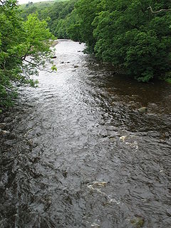
The river flows eastwards through Weardale
, one of the larger valleys of west County Durham
, subsequently turning south-east, and then north-east, meandering its way through the Wear Valley and County Durham to the North Sea
where it outfalls at Wearmouth on Wearside
in Sunderland
. The 60 miles (97 km) from head to mouth. Prior to the creation of Tyne and Wear
, the Wear had been the longest river in England with a course entirely within one county. The Weardale Way
, a long-distance public footpath, roughly follows the entire route, including the length of Killhope Burn.
 There are several towns, sights and tourist places along the length of the river. The market town of Stanhope
is known in part for the ford across the river. From here the river is followed by the line of the Weardale Railway
, which crosses the river several times, through Frosterley
, Wolsingham
, and Witton-le-Wear
to Bishop Auckland
.
the Wear passes below Auckland Park and Auckland Castle
, the official residence of the Bishop of Durham and its deer park
. A mile or so downstream from here, the Wear passes Binchester Roman Fort
, Vinovia, having been crossed by Dere Street
, the Roman road running from Eboracum
(now York
) to Coria
(now Corbridge
) close to Hadrian's Wall
. From Bishop Auckland the River Wear meanders in a general northeasterly direction, demonstrating many fluvial features of a mature river, including wide valley walls, fertile flood plains and ox-bow lakes. Bridges over the river become more substantial, such as those at Sunderland Bridge (near Croxdale
), and Shincliffe
. At Sunderland Bridge the River Browney
joins the River Wear.
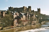
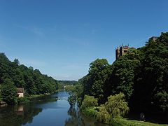 When it reaches the city of Durham
the River Wear passes through a deep, wooded gorge, from which several springs emerge, historically used as sources of potable water. A few coal seams are visible in the banks. Twisting sinuously in an incised meander
, the river has cut deeply into the "Cathedral Sandstone" bedrock. The high ground enclosed by this meander is known as the peninsula, forming a defensive enclosure, at whose heart lies Durham Castle
and Durham Cathedral
and which developed around the Bailey
into Durham city. That area is now a UN World Heritage Site
. Beneath Elvet Bridge
are Brown's Boats (rowing boats for hire) and the mooring for the Prince Bishop, a pleasure cruiser.
The River Wear at Durham was featured on a television programme Seven Natural Wonders
as one of the wonders of Northern England
.
In June each year, the Durham Regatta
, which predates that at Henley
, attracts rowing crews from around the region for races along the river's course through the city. Seven smaller Regattas and Head Races are held throughout the rest of the year, which attract a lower number of competitors. There are 14 boathouses and 20 boat clubs based on the Wear in Durham.
Two weirs impede the flow of the river at Durham, both originally created for industrial activities. The Old Fulling Mill is now an archaeological museum. The second weir, beneath Milburngate Bridge, now includes a salmon leap and fish counter, monitoring sea trout and salmon
, and is on the site of a former ford. Considering that 138,000 fish have been counted migrating upriver since 1994, it may not be surprising that a family of cormorants live on this weir, and can frequently be watched stretching their wings in an attempt to cool off after feeding.
The river's banks also lend their name to a hymn tune
Elvet Banks
in the LCMS 2006 hymnbook, used (appropriately) for a hymn
for baptism
.
 Between Durham City and Chester-le-Street
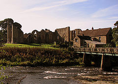
, 6 miles (10 km) due north, the River Wear changes direction repeatedly, flowing south westwards several miles downstream having passed the medieval site of Finchale Priory
, a former chapel and later a satellite monastery depending on the abbey church of Durham Cathedral
. Two miles downstream, the river is flowing south eastwards. The only road bridge over the Wear between Durham and Chester-le-Street is Cocken Bridge. As it passes Chester-le-Street
, where the river is overlooked by Lumley Castle
, its flood plain has been developed into The Riverside
, the home pitch of Durham County Cricket Club
. Passing through the Lambton Estate (still owned by the Lambton family, and briefly a lion park during the 1970s) the river becomes tidal, and therefore navigable.
, specifically the southern/south-eastern edge of the new town of Washington
. At Fatfield
the river passes beneath Worm Hill
, around which the Lambton Worm
is reputed to have curled its tail.
Already the riverbanks are showing evidence of past industrialisation, with former collieries and chemical works. A little further downstream the river passes beneath the Victoria Viaduct, (formally called the Victoria Bridge). Named after the newly-crowned queen, the railway viaduct opened in 1838, was the crowning achievement of the Leamside Line, then carrying what was to become the East Coast Main Line
. A mile to the east is Penshaw Monument
, a local iconic landmark. As the river leaves the environs of Washington, it forms the eastern boundary of Washington Wildfowl Trust
.
 Having flowed beneath the A19 trunk road
, the river enters the suburbs of Sunderland
. The riverbanks show further evidence of past industrialisation, with former collieries, engineering works and dozens of shipyard
s. In their time, Wearside shipbuilders were some of the most famous and productive shipyards in the world. The artist L. S. Lowry
visited Sunderland repeatedly and painted pictures of the industrial landscape around the river. Three bridges cross the Wear in Sunderland: the Queen Alexandra Bridge to the west, and the Wearmouth rail and road bridges in the city centre.
On both banks at this point there are modern developments, some belonging to the University of Sunderland
(St. Peter's Campus; Scotia Quay residences) and to the National Glass Centre
. A riverside sculpture trail
runs alongside this final section of its north bank. The St Peter's Riverside Sculpture Project was created by Colin Wilbourn, with crime novelist and ex-poet Chaz Brenchley
. They worked closely with community groups, residents and schools.
As the river approaches the sea, the north bank (Roker) has a substantial residential development and marina. A dolphin nicknamed Freddie was a frequent visitor to the marina, attracting much local publicity. However, concern was expressed that acclimatising the dolphin to human presence might put at risk the safety of the dolphin regarding the propellors of marine craft. The south bank of the river is occupied by what remains of the Port of Sunderland, once thriving and now almost gone.
The River Wear flows out of Sunderland between Roker
Pier and South Pier, and into the North Sea
.
North East England
North East England is one of the nine official regions of England. It covers Northumberland, County Durham, Tyne and Wear, and Teesside . The only cities in the region are Durham, Newcastle upon Tyne and Sunderland...
, rising in the Pennines
Pennines
The Pennines are a low-rising mountain range, separating the North West of England from Yorkshire and the North East.Often described as the "backbone of England", they form a more-or-less continuous range stretching from the Peak District in Derbyshire, around the northern and eastern edges of...
and flowing eastwards, mostly through County Durham
County Durham
County Durham is a ceremonial county and unitary district in north east England. The county town is Durham. The largest settlement in the ceremonial county is the town of Darlington...
, to the North Sea
North Sea
In the southwest, beyond the Straits of Dover, the North Sea becomes the English Channel connecting to the Atlantic Ocean. In the east, it connects to the Baltic Sea via the Skagerrak and Kattegat, narrow straits that separate Denmark from Norway and Sweden respectively...
at Sunderland.
Geology and history
The Wear rises in the east Pennines, an upland area raised up during the Caledonian orogenyCaledonian orogeny
The Caledonian orogeny is a mountain building era recorded in the northern parts of the British Isles, the Scandinavian Mountains, Svalbard, eastern Greenland and parts of north-central Europe. The Caledonian orogeny encompasses events that occurred from the Ordovician to Early Devonian, roughly...
. Specifically, the Weardale Granite underlies the headwaters of the Wear. Devonian Old Red Sandstone
Old Red Sandstone
The Old Red Sandstone is a British rock formation of considerable importance to early paleontology. For convenience the short version of the term, 'ORS' is often used in literature on the subject.-Sedimentology:...
in age, the Weardale Granite does not outcrop, but was initially surmised, and subsequently proved, as a result of the Rookhope borehole. It is the presence of this granite that has both retained the upland nature of this area (less through its relative hardness, and more due to isostatic equilibrium), and accounts for heavy local mineralisation, although it is considered that most of the mineralisation occurred during the Carboniferous period. Mining of lead ore has been known in the area of the headwaters of the Wear since Roman times, and continued into the nineteenth century when it accounts for the early extension of the then-new railways westwards along the Wear valley
Wear Valley
Wear Valley was, from 1974 to 2009, a local government district in County Durham, England. Its council was based in Crook.The district covered much of the Weardale area. In the west it was parished and rural, whereas in the east it was more urban...
. Fluorspar, another mineral associated with the intrusion of the Weardale Granite, became important in the manufacture of steel from the late c19 into the c20; previously unwanted dumps of it were taken away for this purpose. Along with overlying Carboniferous Limestone
Carboniferous limestone
Carboniferous Limestone is a term used to describe a variety of different types of limestone occurring widely across Great Britain and Ireland which were deposited during the Dinantian epoch of the Carboniferous period. They were formed between 363 and 325 million years ago...
and Carboniferous
Carboniferous
The Carboniferous is a geologic period and system that extends from the end of the Devonian Period, about 359.2 ± 2.5 Mya , to the beginning of the Permian Period, about 299.0 ± 0.8 Mya . The name is derived from the Latin word for coal, carbo. Carboniferous means "coal-bearing"...
Coal Measures, both important raw materials for iron and steel manufacture, as well as Carboniferous
Carboniferous
The Carboniferous is a geologic period and system that extends from the end of the Devonian Period, about 359.2 ± 2.5 Mya , to the beginning of the Permian Period, about 299.0 ± 0.8 Mya . The name is derived from the Latin word for coal, carbo. Carboniferous means "coal-bearing"...
sandstone, useful as a refractory material, the local presence of fluorspar explains why iron and steel manufacture flourished in the Wear valley
Wear Valley
Wear Valley was, from 1974 to 2009, a local government district in County Durham, England. Its council was based in Crook.The district covered much of the Weardale area. In the west it was parished and rural, whereas in the east it was more urban...
, Consett and Teesside during the nineteenth century; ironstone was won from around Consett and Tow Law, then around Rookhope, while greater quantities were imported from south of the Tees. These sources were in due course used up or became uneconomic. Spoil heaps from the abandoned lead mines can still be seen, and since the last quarter of the twentieth century have been the focus of attention for the recovery of gangue
Gangue
In mining, gangue is the commercially worthless material that surrounds, or is closely mixed with, a wanted mineral in an ore deposit. The separation of mineral from gangue is known as mineral processing, mineral dressing or ore dressing and it is a necessary and often significant aspect of mining...
minerals, such as fluorspar for the smelting of aluminium
Aluminium
Aluminium or aluminum is a silvery white member of the boron group of chemical elements. It has the symbol Al, and its atomic number is 13. It is not soluble in water under normal circumstances....
. However, abandoned mines and their spoil heaps continue to contribute to the mineral pollution of the river and its tributaries. This has significance because the River Wear is an important source of drinking water for many of the inhabitants along its course. The former cement works at Eastgate, until recently run by Steetley, was based on an inlier of limestone.
The upland area of Upper Weardale retains a flora that relates, almost uniquely in England
England
England is a country that is part of the United Kingdom. It shares land borders with Scotland to the north and Wales to the west; the Irish Sea is to the north west, the Celtic Sea to the south west, with the North Sea to the east and the English Channel to the south separating it from continental...
, to the end of the last Ice Age
Wisconsin glaciation
The last glacial period was the most recent glacial period within the current ice age occurring during the last years of the Pleistocene, from approximately 110,000 to 10,000 years ago....
, although it almost or entirely lacks the particular rarities that make up the unique "Teesdale Assemblage" of post-glacial plants. This may, in part, be due to the Pennine areas of Upper Weardale and Upper Teesdale being the site of the shrinking ice cap
Ice cap
An ice cap is an ice mass that covers less than 50 000 km² of land area . Masses of ice covering more than 50 000 km² are termed an ice sheet....
. The glaciation left behind many indications of its presence, including lateral moraines and material from the Lake District
Lake District
The Lake District, also commonly known as The Lakes or Lakeland, is a mountainous region in North West England. A popular holiday destination, it is famous not only for its lakes and its mountains but also for its associations with the early 19th century poetry and writings of William Wordsworth...
and Northumberland, although surprisingly few drumlins. After the Ice Age, the Wear valley became thickly forested. During the Neolithic period
Neolithic
The Neolithic Age, Era, or Period, or New Stone Age, was a period in the development of human technology, beginning about 9500 BC in some parts of the Middle East, and later in other parts of the world. It is traditionally considered as the last part of the Stone Age...
and increasingly in the Bronze Age
Bronze Age
The Bronze Age is a period characterized by the use of copper and its alloy bronze as the chief hard materials in the manufacture of some implements and weapons. Chronologically, it stands between the Stone Age and Iron Age...
, the forests were progressively cleared for agriculture.
It is thought that the course of the River Wear, prior to the last Ice Age
Ice age
An ice age or, more precisely, glacial age, is a generic geological period of long-term reduction in the temperature of the Earth's surface and atmosphere, resulting in the presence or expansion of continental ice sheets, polar ice sheets and alpine glaciers...
, was much as it is now as far as Chester-le-Street. This can be established as a result of boreholes, of which there have been many in the Wear valley due to coal mining
Coal mining
The goal of coal mining is to obtain coal from the ground. Coal is valued for its energy content, and since the 1880s has been widely used to generate electricity. Steel and cement industries use coal as a fuel for extraction of iron from iron ore and for cement production. In the United States,...
. However, northwards from Chester-le-Street, the Wear may have originally followed the current route of the lower River Team
River Team
The River Team is a tributary of the River Tyne in Gateshead, England.Its source is near Annfield Plain, where it is known as Kyo Burn. Then changing its name again to Causey Burn as it flows underneath the famous Causey Arch. It then flows past Beamish Museum in County Durham then crosses the...
. The last glaciation reached its peak about 18,500 years ago, from which time it also began a progressive retreat, leaving a wide variety of glacial deposits in its wake, filling existing river valleys with silt, sand and other glacial till
Till
thumb|right|Closeup of glacial till. Note that the larger grains in the till are completely surrounded by the matrix of finer material , and this characteristic, known as matrix support, is diagnostic of till....
. At about 14,000 years ago, retreat of the ice paused for maybe 500 years at the city of Durham
Durham
Durham is a city in north east England. It is within the County Durham local government district, and is the county town of the larger ceremonial county...
. This can be established by the types of glacial deposits in the vicinity of Durham City. The confluence of the River Browney
River Browney
The River Browney is a river in County Durham, England, and the largest tributary of the River Wear.According to Durham County Council Internet GIS, the River Browney rises from a spring in Park Head Plantation, on the eastern slope of Skaylock Hill, roughly a mile south east of Waskerley...
was pushed from Gilesgate (the abandoned river valley still exists in Pelaw Woods), several miles south to Sunderland Bridge (Croxdale). At Chester-le-Street, when glacial boulder clay
Boulder clay
Boulder clay, in geology, is a deposit of clay, often full of boulders, which is formed in and beneath glaciers and ice-sheets wherever they are found, but is in a special sense the typical deposit of the Glacial Period in northern Europe and North America...
was deposited blocking its northerly course, the River Wear was diverted eastwards towards Sunderland where it was forced to cut a new, shallower valley. The gorge cut by the river through the Permian magnesian limestone can be seen most clearly at Ford Quarry.
In the 17th edition of Encyclopædia Britannica (1990), reference is made to a pre-Ice Age course of the River Wear outfalling at Hartlepool
Hartlepool
Hartlepool is a town and port in North East England.It was founded in the 7th century AD, around the Northumbrian monastery of Hartlepool Abbey. The village grew during the Middle Ages and developed a harbour which served as the official port of the County Palatine of Durham. A railway link from...
.
Much of the River Wear is associated with the history of the Industrial Revolution
Industrial Revolution
The Industrial Revolution was a period from the 18th to the 19th century where major changes in agriculture, manufacturing, mining, transportation, and technology had a profound effect on the social, economic and cultural conditions of the times...
. Its upper end runs through lead mining country, until this gives way to coal seams of the Durham coalfield for the rest of its length. As a result of limestone quarrying, lead mining and coal mining, the Wear valley was amongst the first places to see the development of railways. The Weardale Railway
Weardale Railway
The Weardale Railway is a British single-track branch line railway providing regular daily passenger service between Bishop Auckland , Wolsingham, Frosterley and Stanhope. Services began on 23 May 2010 after a lapse of almost sixty years. The railway originally ran from Bishop Auckland to...
continues to run occasional services between Stanhope and Wolsingham.
Course
Rising in the east PenninesPennines
The Pennines are a low-rising mountain range, separating the North West of England from Yorkshire and the North East.Often described as the "backbone of England", they form a more-or-less continuous range stretching from the Peak District in Derbyshire, around the northern and eastern edges of...
, its head waters consisting of several streams draining from the hills between Killhope Law and Burnhope Seat
Burnhope Seat
Burnhope Seat is a moor in the North Pennines of England. It lies between the heads of the Rivers Tees, South Tyne and Wear. The summit is crossed by the boundary between County Durham and Cumbria...
, the head of the river is held to be in Wearhead
Wearhead
Wearhead is a village in County Durham, in England. It is situated at the top of Weardale between Cowshill and Ireshopeburn. It is named after the nearby source of the River Wear which runs eastwards for approx 40 miles to Sunderland....
, County Durham
County Durham
County Durham is a ceremonial county and unitary district in north east England. The county town is Durham. The largest settlement in the ceremonial county is the town of Darlington...
at the confluence of Burnhope Burn and Killhope Burn. This is shown on Ordnance Survey maps, and on the County Durham GIS online. However, a map produced by Durham County Council, and used on an interpretation board at Cowshill shows the River Wear extending from Wearhead to Killhope. Excepting that this apparent extension of the Wear is an error, it can be assumed that there are attempts to reclassify Killhope Burn as the River Wear. This would make sense, as it would then give the River Wear a source.
The river flows eastwards through Weardale
Weardale
Weardale is a dale, or valley, of the east side of the Pennines in County Durham, in England. Large parts of Weardale fall within the North Pennines Area of Outstanding Natural Beauty - the second largest AONB in England and Wales. The upper valley is surrounded by high fells and heather grouse...
, one of the larger valleys of west County Durham
County Durham
County Durham is a ceremonial county and unitary district in north east England. The county town is Durham. The largest settlement in the ceremonial county is the town of Darlington...
, subsequently turning south-east, and then north-east, meandering its way through the Wear Valley and County Durham to the North Sea
North Sea
In the southwest, beyond the Straits of Dover, the North Sea becomes the English Channel connecting to the Atlantic Ocean. In the east, it connects to the Baltic Sea via the Skagerrak and Kattegat, narrow straits that separate Denmark from Norway and Sweden respectively...
where it outfalls at Wearmouth on Wearside
Wearside
Wearside is an area of north east England, centred on the continuous urban area formed by Sunderland, Seaham and other settlements by the River Wear. Mackems is a nickname used for the people of Wearside....
in Sunderland
City of Sunderland
The City of Sunderland is a local government district of Tyne and Wear, in North East England, with the status of a city and metropolitan borough...
. The 60 miles (97 km) from head to mouth. Prior to the creation of Tyne and Wear
Tyne and Wear
Tyne and Wear is a metropolitan county in north east England around the mouths of the Rivers Tyne and Wear. It came into existence as a metropolitan county in 1974 after the passage of the Local Government Act 1972...
, the Wear had been the longest river in England with a course entirely within one county. The Weardale Way
Weardale Way
Weardale Way is a footpath that follows the River Wear in the North East of England. It is 73 miles long, starting at the Lindesfarne Memorial on the sea wall at Roker . It then passes through Chester-le-Street, Durham, Bishop Auckland, Wolsingham and Stanhope...
, a long-distance public footpath, roughly follows the entire route, including the length of Killhope Burn.
Wearhead to Bishop Auckland
Stanhope, County Durham
Stanhope is a small market town in County Durham, in England. It is situated on the River Wear between Eastgate and Frosterley on the north side of Weardale. The A689 trans-Pennine road meets the B6278 road from Barnard Castle to Shotley Bridge here....
is known in part for the ford across the river. From here the river is followed by the line of the Weardale Railway
Weardale Railway
The Weardale Railway is a British single-track branch line railway providing regular daily passenger service between Bishop Auckland , Wolsingham, Frosterley and Stanhope. Services began on 23 May 2010 after a lapse of almost sixty years. The railway originally ran from Bishop Auckland to...
, which crosses the river several times, through Frosterley
Frosterley
Frosterley is a village in County Durham, in England. It is situated in Weardale, on the River Wear close to its confluence with Bollihope Burn; between Wolsingham and Stanhope; 18 miles west of Durham City and 26 miles southwest of Newcastle-upon-Tyne....
, Wolsingham
Wolsingham
Wolsingham is a small market town in Weardale, County Durham, England. It is situated by the River Wear, between Crook and Stanhope in North West Durham.-History:Wolsingham sits at the confluence of the River Wear and Waskerley Beck...
, and Witton-le-Wear
Witton-le-Wear
Witton-le-Wear is a small village in County Durham, England. It is situated on the north bank of the River Wear, to the north-west of Bishop Auckland.-Geography and administration:...
to Bishop Auckland
Bishop Auckland
Bishop Auckland is a market town and civil parish in County Durham in north east England. It is located about northwest of Darlington and southwest of Durham at the confluence of the River Wear with its tributary the River Gaunless...
.
Bishop Auckland to Durham
On the edge of Bishop AucklandBishop Auckland
Bishop Auckland is a market town and civil parish in County Durham in north east England. It is located about northwest of Darlington and southwest of Durham at the confluence of the River Wear with its tributary the River Gaunless...
the Wear passes below Auckland Park and Auckland Castle
Auckland Castle
Auckland Castle is a castle in the town of Bishop Auckland in County Durham, England....
, the official residence of the Bishop of Durham and its deer park
Medieval deer park
A medieval deer park was an enclosed area containing deer. It was bounded by a ditch and bank with a wooden park pale on top of the bank. The ditch was typically on the inside, thus allowing deer to enter the park but preventing them from leaving.-History:...
. A mile or so downstream from here, the Wear passes Binchester Roman Fort
Binchester Roman Fort
Binchester Roman Fort is situated just over to the north of the town of Bishop Auckland on the banks of the River Wear in County Durham, England...
, Vinovia, having been crossed by Dere Street
Dere Street
Dere Street or Deere Street, was a Roman road between Eboracum and Veluniate, in what is now Scotland. It still exists in the form of the route of many major roads, including the A1 and A68 just north of Corbridge.Its name corresponds with the post Roman Anglo-Saxon kingdom of Deira, through...
, the Roman road running from Eboracum
Eboracum
Eboracum was a fort and city in Roman Britain. The settlement evolved into York, located in North Yorkshire, England.-Etymology:The first known recorded mention of Eboracum by name is dated circa 95-104 AD and is an address containing the Latin form of the settlement's name, "Eburaci", on a wooden...
(now York
York
York is a walled city, situated at the confluence of the Rivers Ouse and Foss in North Yorkshire, England. The city has a rich heritage and has provided the backdrop to major political events throughout much of its two millennia of existence...
) to Coria
Coria
Coria may refer to:People* Rodolfo Coria, Argentine paleontologist* Guillermo Coria, Argentine tennis playerPlacesCoria is a Brythonic equivalent of the Latin Curia and may be used as a place-name in Roman Britain and elsewhere:...
(now Corbridge
Corbridge
Corbridge is a village in Northumberland, England, situated west of Newcastle and east of Hexham. Villages in the vicinity include Halton, Acomb, Aydon and Sandhoe.-Roman fort and town:...
) close to Hadrian's Wall
Hadrian's Wall
Hadrian's Wall was a defensive fortification in Roman Britain. Begun in AD 122, during the rule of emperor Hadrian, it was the first of two fortifications built across Great Britain, the second being the Antonine Wall, lesser known of the two because its physical remains are less evident today.The...
. From Bishop Auckland the River Wear meanders in a general northeasterly direction, demonstrating many fluvial features of a mature river, including wide valley walls, fertile flood plains and ox-bow lakes. Bridges over the river become more substantial, such as those at Sunderland Bridge (near Croxdale
Croxdale
Croxdale is a village in the civil parish of Croxdale and Hett, about 3 miles south of Durham City, in County Durham in England and on the A167 road, formerly part of the Great North Road.It is the location of Croxdale Hall, a Grade I listed building...
), and Shincliffe
Shincliffe
Shincliffe is a village in the County Durham in England. It is situated just over a mile to the south-east of Durham city centre, on the A177 road to Stockton...
. At Sunderland Bridge the River Browney
River Browney
The River Browney is a river in County Durham, England, and the largest tributary of the River Wear.According to Durham County Council Internet GIS, the River Browney rises from a spring in Park Head Plantation, on the eastern slope of Skaylock Hill, roughly a mile south east of Waskerley...
joins the River Wear.
Durham
Durham
Durham is a city in north east England. It is within the County Durham local government district, and is the county town of the larger ceremonial county...
the River Wear passes through a deep, wooded gorge, from which several springs emerge, historically used as sources of potable water. A few coal seams are visible in the banks. Twisting sinuously in an incised meander
Meander
A meander in general is a bend in a sinuous watercourse. A meander is formed when the moving water in a stream erodes the outer banks and widens its valley. A stream of any volume may assume a meandering course, alternately eroding sediments from the outside of a bend and depositing them on the...
, the river has cut deeply into the "Cathedral Sandstone" bedrock. The high ground enclosed by this meander is known as the peninsula, forming a defensive enclosure, at whose heart lies Durham Castle
Durham Castle
Durham Castle is a Norman castle in the city of Durham, England, which has been wholly occupied since 1840 by University College, Durham. It is open to the general public to visit, but only through guided tours, since it is in use as a working building and is home to over 100 students...
and Durham Cathedral
Durham Cathedral
The Cathedral Church of Christ, Blessed Mary the Virgin and St Cuthbert of Durham is a cathedral in the city of Durham, England, the seat of the Anglican Bishop of Durham. The Bishopric dates from 995, with the present cathedral being founded in AD 1093...
and which developed around the Bailey
The Bailey
The Bailey, or The Peninsula, is an historic area in the centre of Durham, England. It is shaped like a peninsula thanks to a sharp meander in the River Wear, formed by isostatic adjustment of the land. The name 'The Bailey' derives from it being the 'outer bailey' of the Norman motte and...
into Durham city. That area is now a UN World Heritage Site
World Heritage Site
A UNESCO World Heritage Site is a place that is listed by the UNESCO as of special cultural or physical significance...
. Beneath Elvet Bridge
Elvet Bridge
Elvet Bridge is a mediaeval masonry arch bridge across the River Wear, in the city of Durham, in County Durham, in England. It links the peninsula in central Durham to the Elvet area of the city, and is a Grade I listed building.-History:...
are Brown's Boats (rowing boats for hire) and the mooring for the Prince Bishop, a pleasure cruiser.
The River Wear at Durham was featured on a television programme Seven Natural Wonders
Seven Natural Wonders
Seven Natural Wonders was a television series that was broadcast on BBC Two from 3 May to 20 June 2005. The programme took an area of England each week and, from votes by the people living in that area, showed the 'seven natural wonders' of that area in a programme.The programmes were:The series...
as one of the wonders of Northern England
Northern England
Northern England, also known as the North of England, the North or the North Country, is a cultural region of England. It is not an official government region, but rather an informal amalgamation of counties. The southern extent of the region is roughly the River Trent, while the North is bordered...
.
In June each year, the Durham Regatta
Durham Regatta
Durham Regatta is the premier rowing event in the North East of England, held each year on the second weekend in June on the River Wear which provides a picturesque setting for regattas and head races....
, which predates that at Henley
Henley Royal Regatta
Henley Royal Regatta is a rowing event held every year on the River Thames by the town of Henley-on-Thames, England. The Royal Regatta is sometimes referred to as Henley Regatta, its original name pre-dating Royal patronage...
, attracts rowing crews from around the region for races along the river's course through the city. Seven smaller Regattas and Head Races are held throughout the rest of the year, which attract a lower number of competitors. There are 14 boathouses and 20 boat clubs based on the Wear in Durham.
Two weirs impede the flow of the river at Durham, both originally created for industrial activities. The Old Fulling Mill is now an archaeological museum. The second weir, beneath Milburngate Bridge, now includes a salmon leap and fish counter, monitoring sea trout and salmon
Salmon
Salmon is the common name for several species of fish in the family Salmonidae. Several other fish in the same family are called trout; the difference is often said to be that salmon migrate and trout are resident, but this distinction does not strictly hold true...
, and is on the site of a former ford. Considering that 138,000 fish have been counted migrating upriver since 1994, it may not be surprising that a family of cormorants live on this weir, and can frequently be watched stretching their wings in an attempt to cool off after feeding.
The river's banks also lend their name to a hymn tune
Hymn tune
A hymn tune is the melody of a musical composition to which a hymn text is sung. Musically speaking, a hymn is generally understood to have four-part harmony, a fast harmonic rhythm , and no refrain or chorus....
Elvet Banks
Elvet Banks
Elvet Banks is a modern hymn tune, in the somewhat unusual meter of 87.87.87.87.7, set in the Lutheran Service Book of 2006 for the hymns:* To Jordan came the Christ, our Lord, recommended for use in Epiphany and set as an alternative to the sixteenth century chorale tune Christ unser Herr* May God...
in the LCMS 2006 hymnbook, used (appropriately) for a hymn
Hymn
A hymn is a type of song, usually religious, specifically written for the purpose of praise, adoration or prayer, and typically addressed to a deity or deities, or to a prominent figure or personification...
for baptism
Baptism
In Christianity, baptism is for the majority the rite of admission , almost invariably with the use of water, into the Christian Church generally and also membership of a particular church tradition...
.
Durham to Chester-le-Street
Chester-le-Street
Chester-le-Street is a town in County Durham, England. It has a history going back to Roman times when it was called Concangis. The town is located south of Newcastle upon Tyne and west of Sunderland on the River Wear...
, 6 miles (10 km) due north, the River Wear changes direction repeatedly, flowing south westwards several miles downstream having passed the medieval site of Finchale Priory
Finchale Priory
Finchale Priory was a 13th century Benedictine priory. The remains are sited by the River Wear, four miles from Durham. It is a Grade I listed building.-Current Situation:...
, a former chapel and later a satellite monastery depending on the abbey church of Durham Cathedral
Durham Cathedral
The Cathedral Church of Christ, Blessed Mary the Virgin and St Cuthbert of Durham is a cathedral in the city of Durham, England, the seat of the Anglican Bishop of Durham. The Bishopric dates from 995, with the present cathedral being founded in AD 1093...
. Two miles downstream, the river is flowing south eastwards. The only road bridge over the Wear between Durham and Chester-le-Street is Cocken Bridge. As it passes Chester-le-Street
Chester-le-Street
Chester-le-Street is a town in County Durham, England. It has a history going back to Roman times when it was called Concangis. The town is located south of Newcastle upon Tyne and west of Sunderland on the River Wear...
, where the river is overlooked by Lumley Castle
Lumley Castle
Lumley Castle is a 14th century quadrangular castle at Chester-le-Street in the North of England, near to the city of Durham and a property of the Earl of Scarbrough. It is a Grade I listed building.-History:...
, its flood plain has been developed into The Riverside
Riverside Ground
The Riverside Ground, officially called the Emirates Durham International Cricket Ground, is a cricket venue in Chester-le-Street, County Durham, England. It is home to Durham County Cricket Club....
, the home pitch of Durham County Cricket Club
Durham County Cricket Club
Durham County Cricket Club is one of the 18 major county clubs which make up the English and Welsh national cricket structure, representing the historic county of Durham. Its limited overs team is called the Durham Dynamos. Their kit colours are blue with yellow trim and the shirt sponsor was...
. Passing through the Lambton Estate (still owned by the Lambton family, and briefly a lion park during the 1970s) the river becomes tidal, and therefore navigable.
Chester-le-Street to Sunderland
On exiting the Lambton estate the river leaves County Durham and enters the City of SunderlandCity of Sunderland
The City of Sunderland is a local government district of Tyne and Wear, in North East England, with the status of a city and metropolitan borough...
, specifically the southern/south-eastern edge of the new town of Washington
Washington, Tyne and Wear
Washington is a town in the City of Sunderland in Tyne and Wear, England. Historically part of County Durham, it joined a new county in 1974 with the creation of Tyne and Wear...
. At Fatfield
Fatfield
Fatfield is a village in Tyne and Wear, located in the City of Sunderland metropolitan borough, England. It formed part of the Washington new town....
the river passes beneath Worm Hill
Lambton Worm
The Lambton Worm is a legend from North East England in the UK. The story takes place around the River Wear, and is one of the area's most famous pieces of folklore, having been adapted from written and oral tradition into pantomime and song formats....
, around which the Lambton Worm
Lambton Worm
The Lambton Worm is a legend from North East England in the UK. The story takes place around the River Wear, and is one of the area's most famous pieces of folklore, having been adapted from written and oral tradition into pantomime and song formats....
is reputed to have curled its tail.
Already the riverbanks are showing evidence of past industrialisation, with former collieries and chemical works. A little further downstream the river passes beneath the Victoria Viaduct, (formally called the Victoria Bridge). Named after the newly-crowned queen, the railway viaduct opened in 1838, was the crowning achievement of the Leamside Line, then carrying what was to become the East Coast Main Line
East Coast Main Line
The East Coast Main Line is a long electrified high-speed railway link between London, Peterborough, Doncaster, Wakefield, Leeds, York, Darlington, Newcastle and Edinburgh...
. A mile to the east is Penshaw Monument
Penshaw Monument
Penshaw Monument is a folly built in 1844 on Penshaw Hill between the districts of Washington and Houghton-le-Spring, within the City of Sunderland, North East England...
, a local iconic landmark. As the river leaves the environs of Washington, it forms the eastern boundary of Washington Wildfowl Trust
WWT Washington
WWT Washington is a wetland reserve managed by the Wildfowl and Wetlands Trust at Washington, Tyne and Wear, North East England. The site is part of James Steel Park....
.
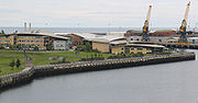
Sunderland
A19 road
The A19 is a major road in England running approximately parallel to and east of the A1 road, although the two roads meet at the northern end of the A19, the two roads originally met at the southern end of the A19 in Doncaster but the old route of the A1 was changed to the A638. From Sunderland...
, the river enters the suburbs of Sunderland
City of Sunderland
The City of Sunderland is a local government district of Tyne and Wear, in North East England, with the status of a city and metropolitan borough...
. The riverbanks show further evidence of past industrialisation, with former collieries, engineering works and dozens of shipyard
Shipyard
Shipyards and dockyards are places which repair and build ships. These can be yachts, military vessels, cruise liners or other cargo or passenger ships. Dockyards are sometimes more associated with maintenance and basing activities than shipyards, which are sometimes associated more with initial...
s. In their time, Wearside shipbuilders were some of the most famous and productive shipyards in the world. The artist L. S. Lowry
L. S. Lowry
Laurence Stephen Lowry was an English artist born in Barrett Street, Stretford, Lancashire. Many of his drawings and paintings depict nearby Salford and surrounding areas, including Pendlebury, where he lived and worked for over 40 years at 117 Station Road , opposite St...
visited Sunderland repeatedly and painted pictures of the industrial landscape around the river. Three bridges cross the Wear in Sunderland: the Queen Alexandra Bridge to the west, and the Wearmouth rail and road bridges in the city centre.
On both banks at this point there are modern developments, some belonging to the University of Sunderland
University of Sunderland
The University of Sunderland is located in Sunderland, north east England. The university has more than 17,500 students, including 7,000-plus international students from some 70 countries....
(St. Peter's Campus; Scotia Quay residences) and to the National Glass Centre
National Glass Centre
The National Glass Centre is a cultural venue and visitor attraction located in Sunderland, North East England.-Background:The National Glass Centre is located in Monkwearmouth, on the north banks of the River Wear, on the former site of J.L. Thompson and Sons shipyard. The centre is close to the...
. A riverside sculpture trail
Sculpture trail
A sculpture trail—sculpture walk - also known as "a culture walk" - is a walkway through open-air galleries of outdoor sculptures along a defined route with sequenced viewings encountered from planned preview and principal sight lines.-Settings:...
runs alongside this final section of its north bank. The St Peter's Riverside Sculpture Project was created by Colin Wilbourn, with crime novelist and ex-poet Chaz Brenchley
Chaz Brenchley
Chaz Brenchley is a British writer of novels and short stories, associated with the genres of horror, crime and fantasy....
. They worked closely with community groups, residents and schools.
As the river approaches the sea, the north bank (Roker) has a substantial residential development and marina. A dolphin nicknamed Freddie was a frequent visitor to the marina, attracting much local publicity. However, concern was expressed that acclimatising the dolphin to human presence might put at risk the safety of the dolphin regarding the propellors of marine craft. The south bank of the river is occupied by what remains of the Port of Sunderland, once thriving and now almost gone.
The River Wear flows out of Sunderland between Roker
Roker
Roker is a tourist resort and affluent area of Sunderland, North East England, bounded on the south by the River Wear and Monkwearmouth, on the east by the North Sea, to the west by Fulwell and on the north by Seaburn. It is administered as part of the City of Sunderland.The majority of the...
Pier and South Pier, and into the North Sea
North Sea
In the southwest, beyond the Straits of Dover, the North Sea becomes the English Channel connecting to the Atlantic Ocean. In the east, it connects to the Baltic Sea via the Skagerrak and Kattegat, narrow straits that separate Denmark from Norway and Sweden respectively...
.
See also
- List of crossings of the River Wear
- Rowing clubs on the River WearRowing clubs on the River WearThe River Wear is home to a number of sports rowing clubs. These clubs are based in Durham, Chester-le-Street and Sunderland. All clubs are members of British Rowing and all the Durham College clubs are members of Durham College Rowing.-Durham:...
- List of rivers of England
- Harry WattsHarry WattsHarry Watts was a Sunderland sailor and diver, who rescued over 40 people from drowning during his lifetime - and assisted in the rescue of another 120 people.-Early life:...
– multiple River Wear life-saver
Sources
- Natural Environment Research CouncilNatural Environment Research CouncilThe Natural Environment Research Council is a British research council that supports research, training and knowledge transfer activities in the environmental sciences.-History:...
, Institute of Geological Sciences, 1971, "British Regional Geology: Northern England" Fourth Edition, HMSO, London. - Johnson, G.A.L. & Hickling, G. (eds.), 1972, "Geology of Durham County", Transactions of the Natural History Society of Northumberland, Durham and Newcastle-upon-Tyne, Vol.41, No.1.
- 'Wear River', "Encyclopaedia Britannica", 17th Edition, 1990.