

Comanche County, Oklahoma
Encyclopedia
Comanche County is a county located in the U.S. state
of Oklahoma
. Built on former reservation lands of the Comanche
, Kiowa
, and Apache in Indian Territory
, Comanche County was open for settlement on August 16, 1901 by lottery. The region has three cities and seven towns as well as the Fort Sill
military instillation and Wichita Mountains Wildlife Refuge. The landscape of the county is typical of the Great Plains with flat topography and gently rolling hills, while the areas in the north are marked by the Wichita Mountains
. Interstate 44
and three major US Highways
serve the county by ground, while the Lawton-Fort Sill Regional Airport
serves the county by air.
According to the 2010 US Census, the population of the county was 124,098. It is included in the Lawton Metropolitan Statistical Area
with the city of Lawton
as its county seat
. Comanche County's economy is largely based in the government sector which consist of half of the county's Gross Domestic Product
. The governance of the county is led by a three commission board, which are elected in four year staggered terms. The county is served by several school districts and Cameron University
in education as well as three hospitals for health care.
11500 BC, Folsom
10600 BC and Plainview
10000 BC cultures. Western explorers came to the region in the 16th century with Spanish explorer Francisco Vásquez de Coronado
visiting in 1541. Most of the region during this time was settled by the Wichita and Caddo
people. Around the 1700s, two tribes from the North, the Comanches and Kiowas, migrated to the Oklahoma and Texas region.
For most of the 18th century, the Oklahoma region was under French control as Louisiana
. In 1803, the Louisiana Purchase
by Thomas Jefferson
brought the area under United States control. In 1830, Congress passed the Indian Removal Act
, which removed American Indian tribes and relocated them to Indian Territory
. The southern part of the territory was originally assigned to the Choctaw
and Chickasaw
until 1867 when the Medicine Lodge Treaty
allotted the southwest portion of the Choctaw and Chickasaw’s lands to the Comanche
, Kiowa
, and Apache
tribes.
Fort Sill
was established in 1869 by Major General Philip Sheridan
who was leading a campaign in Indian Territory to stop raids into Texas by American Indian tribes. In 1874, the Red River War
broke out in the region when the Comanche, Kiowa and Southern Cheyenne left their Indian Territory reservation. Attrition and skirmishes by the US Army finally forced the return of the tribes back to Indian Territory in June 1875.
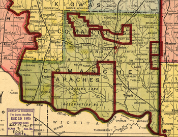 In 1891, the United States Congress appointed a commission to meet with the tribal leaders and come to an agreement allowing white settlement in the region. Years of controversy and legal maneuvering ensued before President William McKinley
issued a proclamation on July 4, 1901, that gave the federal government control over 2000000 acres (8,093.7 km²) of surplus Indian land.
Three 320 acres (1.3 km²) sites in Kiowa
, Caddo
and Comanche Counties were selected for county seats with Lawton designated as the Comanche County seat. Non-Indian settlement was opened through an auction of lots beginning on August 6, 1901. In December 1906, the south regions of the county reserved for grazing land reserved for American Indian livestock, Big Pasture
, were open for settlement.
In 1910, the western portion of Comanche County and southern part of Kiowa County were used to create the short lived county of Swanson
. After a lawsuit brought by Comanche County, Swanson County was dissolved by the Supreme Court on June 27, 1911. In 1912, the southern portion of Comanche County, which at the time extended to the Red River, were used to create the new county of Cotton County.
with prairie
, few trees, and generally flat topography with gently rolling hills. According to the U.S. Census Bureau
, the county has a total area of 1084 square miles (2,807.5 km²), of which 1069 square miles (2,768.7 km²) is land and 14 square miles (36.3 km²) (1.34%) is water. The north region of the county consists of the Wichita Mountains
including Mount Scott
and Mount Pinchot the area's highest peaks.
The area consists mostly of Permian
Post Oak Conglomerate limestone
on the northern sections of the county. In the south sections of the county, Permian Garber sandstone is commonly found with some Hennessey Group shale. Area creeks including East Cache Creek and West Cache Creek contain deposits of Quaternary
Alluvium
. To the northwest, the Wichita Mountains consist primarily of Wichita Granite Group from the Cambrian
era.
There are three cities in Comanche County. The largest, Lawton
is located in the center of the county and is the county seat. According to the US census, the population of Lawton was 96,867 in 2010, which is consists 78 percent of the county's population. Cache
is located to the west of Lawton on US Highway 62
and has a population of 2,796. In the northeast, Elgin is located along Interstate 44
and has a population of 2,156. Several towns dot the county including: Fletcher
, Sterling
in the northeast, Medicine Park
in the north central region, Indiahoma
in the west, Geronimo
in the southeast, and Chattanooga
and Faxon
in the southern regions of the county. Also located in Comanche County is Fort Sill. The 90,000 acre instillation is home to the US Army Field Artillery Training Center and the Air Defense Artillery.
Protected areas in Comanche County include the 59,020 acre Wichita Mountains Wildlife Refuge. Established in 1901 the refuge is one of the 546 wildlife refuges throughout the United States to provide a natural habitat for native grazing animals like the Bison, Elk, and Texas longhorn cattle.
(Köppen climate classification
Cfa), with frequent variations in weather daily, except during the constantly hot and dry summer months. Frequent strong winds, usually from the south or south-southeast during the summer, help to lessen the hotter weather. Northerly winds during the winter can occasionally intensify cold periods.
The average mean temperature for the southwest Oklahoma is 61.9 °F (16.6 °C). The summers can be extremely hot with an average 21 days with temperatures 100 °F (37.8 °C) and above. The winter months are typically mild, though there can be periods of extreme cold. The area averages 8 days that fail to rise above freezing. The region receives about 31.6 inches (802.6 mm) of precipitation and less than 3 inches (76.2 mm) of snow annually.
Typically in late April through early June, Comanche County is prone to severe weather
which can include tornadoes. Notably in 1957, a F4
tornado and again in 1979 a F3
tornado struck the southern region of Lawton.
of 2010, there were 124,098 people, 44,982 households, and 30,303 families residing in the county. The population density
was 116 people per square mile (45/km²). There were 50,739 housing units at an average density of 47 per square mile (18/km²). The racial makeup of the county was 64.5% White
, 17.5% Black
or African American
, 5.9% Native American
, 2.2% Asian
, 0.6% Pacific Islander
, 3.0% from other races
, and 6.5% from two or more races. 11.2% of the population were Hispanic
or Latino
of any race.
There were 44,982 households out of which 36.5% had children under the age of 18 living with them, 48.2% were married couples
living together, 14.5% had a female householder with no husband present, and 32.6% were non-families. 27.1% of all households were made up of individuals and 7.8% had someone living alone who was 65 years of age or older. The average household size was 2.53 and the average family size was 3.07.
In the county, the population was spread out with 25.1% under the age of 18, 13.6% from 18 to 24, 30.1% from 25 to 44, 23.3% from 45 to 64, and 10.2% who were 65 years of age or older. The median age was 31.3 years. For every 100 females there were 106.2 males. For every 100 females age 18 and over, there were 107.3 males.
The median income for a household in the county was $43,817, and the median income for a family was $51,564. Males had a median income of $37,423 versus $31,913 for females. The per capita income
for the county was $21,048. About 14.3% of families and 17.6% of the population were below the poverty line, including 29.4% of those under age 18 and 8.1% of those age 65 or over.
comprising three members elected by district. Commissioners from each district serve four-year staggered terms in partisan elections. Boundaries are set once every 10 years following the federal census
. The Board is responsible for inspecting and approving county programs and facilities, supervise the performance county officials, maintaining the county infrastructure, as well as overseeing the financial affairs of the county. In 2011, the commissioners were District 1 Gail Turner, District 2 Ron Kirby, and District 3 Don Hawthorne. In addition to the county commissioners, other elected county officials include: District Attorney
, County Sheriff
, Treasurer
, Assessor, County Clerk
, and Court clerk
.
At the federal level, Lawton lies in Oklahoma 4th Congressional district
, represented by Tom Cole
. In the State Senate
, the county is represented by District 31 (Don Barrington) and 32 (Randy Bass). In the House
, District 50 (Dennis Johnson), 62 (T.W. Shannon), 63 (Don Armes), 64 (Ann Coody), 65 (Joe Dorman) covers the county.
of $4.89 Billion in 2010 with half (2.66 Billion) in the Government sector. Private industries accounted for 2.23 Billion in GDP in which Manufacturing (451 Million), Real estate and rental and leasing (305 Million), and Retail Trade (255 Million) were the largest fields. In May 2010, it was estimated there were 41,720 people employed. The largest occupation fields included, the Office and Administrative Support Occupations field which had 6,760 employed, the Food Preparation and Serving Related Occupations which employed 4,630, and the Sales and Related Occupations which had 4,150 employed.
is the only daily newspaper published in the county and has a circulation of 30,000. In addition the Fort Sill newspaper, The Cannoneer, is published weekly primarily for military personnel as well as the newspaper The Cameron Collegian whose main audience is Cameron University students. Additionally, Okie Magazine is a monthly magazine that focuses on news and entertainment in the Southwest Oklahoma area.
Radio stations in Lawton include, two AM Stations KKRX
1050 and KXCA
1380 as well as several FM stations including, NPR affiliate KCCU
89.3, KZCD
94.1, KMGZ
95.3, KJMZ
97.9, KBZQ
99.5, KLAW 101.3 and KVRW
107.3
Comanche County is located in the Wichita Falls and Lawton Media Market which encompasses 154,450 households with a television, making it the 149th largest in the nation according to Nelson Media Research in 2009-2010. KSWO-TV
channel 7, an ABC
affiliate, is the only broadcast television station in the area that provides local news. All other major stations including, KFDX-TV 3 (NBC
), KAUZ-TV (CBS
), and KJTL
-TV (Fox
) are based in Wichita Falls.
, designated as the H. E. Bailey Turnpike
. It connects the county to Oklahoma City
to the northeast and to Wichita Falls, Texas
to the south. The county is also connected by US Highway 62
, which connects to the regional towns of Altus
to the west and Anadarko
to the north. Other major thoroughfares include US Highway 277
and 281
, which parallels the H. E. Bailey Turnpike to Wichita Falls to the south and leads to regional towns of Anadarko
and Chickasha
, respectively, to the north.
Several State Highways cross the county including, State Highway 7 which connects Lawton to Duncan
. State Highway 17 starts at US Highway 62 and connects the city of Elgin to the town of Sterling and leads to Rush Springs
in Grady County. State Highway 36 connects the towns of Chattanooga to Faxon and has its eastern terminus at Interstate 44. State Highway 49
enters the county from Kiowa County and becomes unsigned through the Wichita Wildlife refuge heading east. Leaving the refuge it becomes signed and leads through Medicine Park to its eastern terminus at Interstate 44. State Highway 58
connects to Carnegie
in Caddo County to State Highway 49 near Medicine Park. State Highway 115
leads from Mountain View
in Kiowa County through Meers to the Wichita Mountain Refuge. There it becomes unsigned as it leads to the south. Exiting the refuge, it becomes signed and leads to its southern terminus north of Cache on US Highway 62.
Lawton Area Transit System (LATS) provides public transit locally for Lawton and Fort Sill. LATS main terminal is located near the Lawton Public Library and provides five major routes throughout the city.
By air, Comanche County is served by the Lawton-Fort Sill Regional Airport
(LAW, KLAW). At present, it offers daily American Eagle flights to Dallas/Fort Worth International Airport and is also used for military transport.
which had 16,398 in 2009. The district operates two pre-kindergarten centers, twenty-six elementary schools, four middle schools, and three high schools – Eisenhower
, Lawton
, and MacArthur
. Other major school districts in the area include Cache Public Schools
and Elgin Public Schools
. Cache Public Schools had an enrollment of 1,648 and consists of five schools. Elgin Public Schools had an enrollment of 16,98 and three schools. Other public school districts in the region include, Bishop Chattanooga, Fletcher, Flower Mound, Geronimo, Indiahoma, and Sterling.
Comanche County includes several private schools. The largest is Lawton Christan School with an enrollment of 426 students in 2009. Lawton Academy of Arts & Science offers classes from PK-12 and had an enrollment of 115. St. Mary's Catholic School offers classes for elementary and middle school. Trinity Christian Academy offers classes from K-3 through the 8th grade.
There is one university in Comanche County, Cameron University
. Cameron is the largest four year, state-funded university
, in southwest Oklahoma, offering more than 50 degree programs in areas of Business, Education, Liberal Arts and Science and Technology. Founded in 1909, Cameron has an average fall enrollment of 6,000 students with 70 endowed faculty positions.
Comanche County is also served by the Great Plains Technology Center
, which is part of the Oklahoma Department of Career and Technology Education System. Great Plains provides occupational education, training, and development opportunities to area residents.
Comanche County has three major hospitals in the area. The largest, Comanche County Memorial Hospital, is a 283-bed non-profit hospital that employs 250 physicians. Southwestern Medical Center is a 199-bed hospital with a staff of 150 physicians. In addition, the US Public Health Lawton Indian Hospital is located in the city to provide health services for the large American Indian
population. It has 26 beds with a staff of 23 physicians.
, Kelly Willis
, and Leon Russell
, Grammy nominated jazz trombonist Conrad Herwig
, and Flaming Lips
drummer Steven Drozd
. Notable authors include Pulitzer Prize
winning author N. Scott Momaday
, poet Don Blanding
, and Hugo Award
winner, C.J. Cherryh.
Politicians from Comanche County include: US Senator Thomas Gore
, US Representatives: Scott Ferris
, L. M. Gensman
, Toby Morris
, and Elmer Thomas. Other politicians include Democratic State Senator Randy Bass
and former US Ambassador to Czechoslovakia Julian Niemczyk
.
Other notable residents include: WWII Comanche
Code Talker Charles Chibitty
, WWII Nurse and POW Col. Rosemary Hogan, Academy Award winning actress Joan Crawford
, WWII ace Robert S. Johnson
, three time NBA champion Stacey King, former NBA All-Star Michael Ray Richardson, Miss America 2007 Lauren Nelson
, infamous University of Oklahoma quarterback Charles Thompson, NFL Pro Bowlers Will Shields
and Jammal Brown
U.S. state
A U.S. state is any one of the 50 federated states of the United States of America that share sovereignty with the federal government. Because of this shared sovereignty, an American is a citizen both of the federal entity and of his or her state of domicile. Four states use the official title of...
of Oklahoma
Oklahoma
Oklahoma is a state located in the South Central region of the United States of America. With an estimated 3,751,351 residents as of the 2010 census and a land area of 68,667 square miles , Oklahoma is the 28th most populous and 20th-largest state...
. Built on former reservation lands of the Comanche
Comanche
The Comanche are a Native American ethnic group whose historic range consisted of present-day eastern New Mexico, southern Colorado, northeastern Arizona, southern Kansas, all of Oklahoma, and most of northwest Texas. Historically, the Comanches were hunter-gatherers, with a typical Plains Indian...
, Kiowa
Kiowa
The Kiowa are a nation of American Indians and indigenous people of the Great Plains. They migrated from the northern plains to the southern plains in the late 17th century. In 1867, the Kiowa moved to a reservation in southwestern Oklahoma...
, and Apache in Indian Territory
Indian Territory
The Indian Territory, also known as the Indian Territories and the Indian Country, was land set aside within the United States for the settlement of American Indians...
, Comanche County was open for settlement on August 16, 1901 by lottery. The region has three cities and seven towns as well as the Fort Sill
Fort Sill
Fort Sill is a United States Army post near Lawton, Oklahoma, about 85 miles southwest of Oklahoma City.Today, Fort Sill remains the only active Army installation of all the forts on the South Plains built during the Indian Wars...
military instillation and Wichita Mountains Wildlife Refuge. The landscape of the county is typical of the Great Plains with flat topography and gently rolling hills, while the areas in the north are marked by the Wichita Mountains
Wichita Mountains
The Wichita Mountains are located in the southwestern portion of the U.S. state of Oklahoma. The mountains are a northwest-southeast trending series of rocky promontories, many capped by 540 million-year old granite. These were exposed and rounded by weathering during the Permian Period...
. Interstate 44
Interstate 44 in Oklahoma
Interstate 44 runs diagonally through the U.S. state of Oklahoma, spanning from the Texas state line near Wichita Falls to the Missouri border near Joplin. It connects three of Oklahoma's largest cities, Oklahoma City, Tulsa, and Lawton. Most of I-44 in Oklahoma is a toll road. In southwestern...
and three major US Highways
United States Numbered Highways
The system of United States Numbered Highways is an integrated system of roads and highways in the United States numbered within a nationwide grid...
serve the county by ground, while the Lawton-Fort Sill Regional Airport
Lawton-Fort Sill Regional Airport
Lawton-Fort Sill Regional Airport is a public airport located 2 mi south of Lawton, in Comanche County, Oklahoma, USA. It is mostly used for military aviation from nearby Fort Sill and Sheppard Air Force Base, but is also served by American Eagle...
serves the county by air.
According to the 2010 US Census, the population of the county was 124,098. It is included in the Lawton Metropolitan Statistical Area
Lawton metropolitan area
The Lawton Metropolitan Statistical Area, as defined by the United States Census Bureau, is an area consisting of one county – Comanche – in Oklahoma, anchored by the city of Lawton...
with the city of Lawton
Lawton, Oklahoma
The city of Lawton is the county seat of Comanche County, in the U.S. state of Oklahoma. Located in the southwestern region of Oklahoma approximately southwest of Oklahoma City, it is the principal city of the Lawton Oklahoma Metropolitan Statistical Area...
as its county seat
County seat
A county seat is an administrative center, or seat of government, for a county or civil parish. The term is primarily used in the United States....
. Comanche County's economy is largely based in the government sector which consist of half of the county's Gross Domestic Product
Gross domestic product
Gross domestic product refers to the market value of all final goods and services produced within a country in a given period. GDP per capita is often considered an indicator of a country's standard of living....
. The governance of the county is led by a three commission board, which are elected in four year staggered terms. The county is served by several school districts and Cameron University
Cameron University
Cameron University is a four-year, state-funded university located in Lawton, Oklahoma, that offers more than 50 degrees through two-year, four-year and graduate programs. The degree programs emphasize the liberal arts, science and technology and graduate and professional studies...
in education as well as three hospitals for health care.
History
The land that is present day Oklahoma was first settled by prehistoric American Indians including the ClovisClovis culture
The Clovis culture is a prehistoric Paleo-Indian culture that first appears 11,500 RCYBP , at the end of the last glacial period, characterized by the manufacture of "Clovis points" and distinctive bone and ivory tools...
11500 BC, Folsom
Folsom tradition
The Folsom Complex is a name given by archaeologists to a specific Paleo-Indian archaeological culture that occupied much of central North America...
10600 BC and Plainview
Plano cultures
The Plano cultures is a name given by archaeologists to a group of disparate hunter-gatherer communities that occupied the Great Plains area of North America during the Paleo-Indian period in the United States and the Paleo-Indian or Archaic period in Canada....
10000 BC cultures. Western explorers came to the region in the 16th century with Spanish explorer Francisco Vásquez de Coronado
Francisco Vásquez de Coronado
Francisco Vásquez de Coronado y Luján was a Spanish conquistador, who visited New Mexico and other parts of what are now the southwestern United States between 1540 and 1542...
visiting in 1541. Most of the region during this time was settled by the Wichita and Caddo
Caddo
The Caddo Nation is a confederacy of several Southeastern Native American tribes, who traditionally inhabited much of what is now East Texas, northern Louisiana and portions of southern Arkansas and Oklahoma. Today the Caddo Nation of Oklahoma is a cohesive tribe with its capital at Binger, Oklahoma...
people. Around the 1700s, two tribes from the North, the Comanches and Kiowas, migrated to the Oklahoma and Texas region.
For most of the 18th century, the Oklahoma region was under French control as Louisiana
Louisiana (New France)
Louisiana or French Louisiana was an administrative district of New France. Under French control from 1682–1763 and 1800–03, the area was named in honor of Louis XIV, by French explorer René-Robert Cavelier, Sieur de la Salle...
. In 1803, the Louisiana Purchase
Louisiana Purchase
The Louisiana Purchase was the acquisition by the United States of America of of France's claim to the territory of Louisiana in 1803. The U.S...
by Thomas Jefferson
Thomas Jefferson
Thomas Jefferson was the principal author of the United States Declaration of Independence and the Statute of Virginia for Religious Freedom , the third President of the United States and founder of the University of Virginia...
brought the area under United States control. In 1830, Congress passed the Indian Removal Act
Indian Removal Act
The Indian Removal Act was signed into law by President Andrew Jackson on May 28, 1830.The Removal Act was strongly supported in the South, where states were eager to gain access to lands inhabited by the Five Civilized Tribes. In particular, Georgia, the largest state at that time, was involved in...
, which removed American Indian tribes and relocated them to Indian Territory
Indian Territory
The Indian Territory, also known as the Indian Territories and the Indian Country, was land set aside within the United States for the settlement of American Indians...
. The southern part of the territory was originally assigned to the Choctaw
Choctaw
The Choctaw are a Native American people originally from the Southeastern United States...
and Chickasaw
Chickasaw
The Chickasaw are Native American people originally from the region that would become the Southeastern United States...
until 1867 when the Medicine Lodge Treaty
Medicine Lodge Treaty
The Medicine Lodge Treaty is the overall name for three treaties signed between the United States government and southern Plains Indian tribes in October 1867, intended to bring peace to the area by relocating the Native Americans to reservations in Indian Territory and away from European-American...
allotted the southwest portion of the Choctaw and Chickasaw’s lands to the Comanche
Comanche
The Comanche are a Native American ethnic group whose historic range consisted of present-day eastern New Mexico, southern Colorado, northeastern Arizona, southern Kansas, all of Oklahoma, and most of northwest Texas. Historically, the Comanches were hunter-gatherers, with a typical Plains Indian...
, Kiowa
Kiowa
The Kiowa are a nation of American Indians and indigenous people of the Great Plains. They migrated from the northern plains to the southern plains in the late 17th century. In 1867, the Kiowa moved to a reservation in southwestern Oklahoma...
, and Apache
Fort Sill Apache Tribe
The Fort Sill Apache Tribe is the federally recognized Native American tribe of Chiricahua Warm Springs Apache in Oklahoma.-History:The Fort Sill Apache Tribe is composed of Chiricahua Apache. The Apache are southern Athabaskan-speaking peoples who migrated many centuries ago from the subarctic to...
tribes.
Fort Sill
Fort Sill
Fort Sill is a United States Army post near Lawton, Oklahoma, about 85 miles southwest of Oklahoma City.Today, Fort Sill remains the only active Army installation of all the forts on the South Plains built during the Indian Wars...
was established in 1869 by Major General Philip Sheridan
Philip Sheridan
Philip Henry Sheridan was a career United States Army officer and a Union general in the American Civil War. His career was noted for his rapid rise to major general and his close association with Lt. Gen. Ulysses S...
who was leading a campaign in Indian Territory to stop raids into Texas by American Indian tribes. In 1874, the Red River War
Red River War
The Red River War was a military campaign launched by the United States Army in 1874, as part of the Comanche War, to remove the Comanche, Kiowa, Southern Cheyenne, and Arapaho Native American tribes from the Southern Plains and forcibly relocate them to reservations in Indian Territory...
broke out in the region when the Comanche, Kiowa and Southern Cheyenne left their Indian Territory reservation. Attrition and skirmishes by the US Army finally forced the return of the tribes back to Indian Territory in June 1875.
William McKinley
William McKinley, Jr. was the 25th President of the United States . He is best known for winning fiercely fought elections, while supporting the gold standard and high tariffs; he succeeded in forging a Republican coalition that for the most part dominated national politics until the 1930s...
issued a proclamation on July 4, 1901, that gave the federal government control over 2000000 acres (8,093.7 km²) of surplus Indian land.
Three 320 acres (1.3 km²) sites in Kiowa
Kiowa County, Oklahoma
Kiowa County is a county located in the U.S. state of Oklahoma. As of 2000, the population was 10,227. Its county seat is Hobart.-Geography:According to the U.S. Census Bureau, the county has a total area of . is land and is water....
, Caddo
Caddo County, Oklahoma
Caddo County is a county located in the U.S. state of Oklahoma. As of 2000, the population was 30,150. Its county seat is Anadarko. It is named after the Caddo tribe who were settled here on the 1870s...
and Comanche Counties were selected for county seats with Lawton designated as the Comanche County seat. Non-Indian settlement was opened through an auction of lots beginning on August 6, 1901. In December 1906, the south regions of the county reserved for grazing land reserved for American Indian livestock, Big Pasture
Big Pasture
The Big Pasture was of prairie land, in what is now southwestern Oklahoma. The land had been reserved for grazing use by the Kiowa, Comanche, and Apache tribes after their reserve was opened for settlement by a lottery conducted during June through August 1901...
, were open for settlement.
In 1910, the western portion of Comanche County and southern part of Kiowa County were used to create the short lived county of Swanson
Swanson County, Oklahoma
Swanson County is a defunct county in Oklahoma. It was created from southern Kiowa County and western Comanche County on August 13, 1910, when Governor Charles N. Haskell proclaimed the county as official in response to a special election by the residents. In January 1911, the state House of...
. After a lawsuit brought by Comanche County, Swanson County was dissolved by the Supreme Court on June 27, 1911. In 1912, the southern portion of Comanche County, which at the time extended to the Red River, were used to create the new county of Cotton County.
Geography
Comanche County lies in an area that is typical of the Great PlainsGreat Plains
The Great Plains are a broad expanse of flat land, much of it covered in prairie, steppe and grassland, which lies west of the Mississippi River and east of the Rocky Mountains in the United States and Canada. This area covers parts of the U.S...
with prairie
Prairie
Prairies are considered part of the temperate grasslands, savannas, and shrublands biome by ecologists, based on similar temperate climates, moderate rainfall, and grasses, herbs, and shrubs, rather than trees, as the dominant vegetation type...
, few trees, and generally flat topography with gently rolling hills. According to the U.S. Census Bureau
United States Census Bureau
The United States Census Bureau is the government agency that is responsible for the United States Census. It also gathers other national demographic and economic data...
, the county has a total area of 1084 square miles (2,807.5 km²), of which 1069 square miles (2,768.7 km²) is land and 14 square miles (36.3 km²) (1.34%) is water. The north region of the county consists of the Wichita Mountains
Wichita Mountains
The Wichita Mountains are located in the southwestern portion of the U.S. state of Oklahoma. The mountains are a northwest-southeast trending series of rocky promontories, many capped by 540 million-year old granite. These were exposed and rounded by weathering during the Permian Period...
including Mount Scott
Mount Scott (Oklahoma)
Mount Scott is a prominent mountain just to the northwest of Lawton Oklahoma rising to a height of above sea level. It is located in the Wichita Mountains near Fort Sill Military Reservation and lies in the Wichita Mountains National Wildlife Refuge. The US Fish and Wildlife Service is responsible...
and Mount Pinchot the area's highest peaks.
The area consists mostly of Permian
Permian
The PermianThe term "Permian" was introduced into geology in 1841 by Sir Sir R. I. Murchison, president of the Geological Society of London, who identified typical strata in extensive Russian explorations undertaken with Edouard de Verneuil; Murchison asserted in 1841 that he named his "Permian...
Post Oak Conglomerate limestone
Limestone
Limestone is a sedimentary rock composed largely of the minerals calcite and aragonite, which are different crystal forms of calcium carbonate . Many limestones are composed from skeletal fragments of marine organisms such as coral or foraminifera....
on the northern sections of the county. In the south sections of the county, Permian Garber sandstone is commonly found with some Hennessey Group shale. Area creeks including East Cache Creek and West Cache Creek contain deposits of Quaternary
Quaternary
The Quaternary Period is the most recent of the three periods of the Cenozoic Era in the geologic time scale of the ICS. It follows the Neogene Period, spanning 2.588 ± 0.005 million years ago to the present...
Alluvium
Alluvium
Alluvium is loose, unconsolidated soil or sediments, eroded, deposited, and reshaped by water in some form in a non-marine setting. Alluvium is typically made up of a variety of materials, including fine particles of silt and clay and larger particles of sand and gravel...
. To the northwest, the Wichita Mountains consist primarily of Wichita Granite Group from the Cambrian
Cambrian
The Cambrian is the first geological period of the Paleozoic Era, lasting from Mya ; it is succeeded by the Ordovician. Its subdivisions, and indeed its base, are somewhat in flux. The period was established by Adam Sedgwick, who named it after Cambria, the Latin name for Wales, where Britain's...
era.
There are three cities in Comanche County. The largest, Lawton
Lawton, Oklahoma
The city of Lawton is the county seat of Comanche County, in the U.S. state of Oklahoma. Located in the southwestern region of Oklahoma approximately southwest of Oklahoma City, it is the principal city of the Lawton Oklahoma Metropolitan Statistical Area...
is located in the center of the county and is the county seat. According to the US census, the population of Lawton was 96,867 in 2010, which is consists 78 percent of the county's population. Cache
Cache, Oklahoma
Cache is a city in Comanche County, Oklahoma, United States. The population was 2,796 at the 2010 census. It is an exurb included in the Lawton, Oklahoma Metropolitan Statistical Area...
is located to the west of Lawton on US Highway 62
U.S. Route 62 in Oklahoma
In Oklahoma, U.S. Highway 62 runs diagonally across the state, from the Texas state line in far southwestern Oklahoma to the Arkansas state line near Fayetteville. US-62 spends a total of in the Sooner State. The highway passes through fifteen of Oklahoma's counties...
and has a population of 2,796. In the northeast, Elgin is located along Interstate 44
Interstate 44 in Oklahoma
Interstate 44 runs diagonally through the U.S. state of Oklahoma, spanning from the Texas state line near Wichita Falls to the Missouri border near Joplin. It connects three of Oklahoma's largest cities, Oklahoma City, Tulsa, and Lawton. Most of I-44 in Oklahoma is a toll road. In southwestern...
and has a population of 2,156. Several towns dot the county including: Fletcher
Fletcher, Oklahoma
Fletcher is a town in Comanche County, Oklahoma, United States. The population was 1,177 at the 2010 census. It is included in the Lawton, Oklahoma Metropolitan Statistical Area.-Geography:Fletcher is located at ....
, Sterling
Sterling, Oklahoma
Sterling is a town in Comanche County, Oklahoma, United States. The population was 793 at the 2010 census. It is part of the Lawton Metropolitan Statistical Area.-Geography:Sterling is located at ....
in the northeast, Medicine Park
Medicine Park, Oklahoma
Medicine Park is a town in Comanche County, Oklahoma, United States, situated in the Wichita Mountains near the entrance to the Wichita Mountain Wildlife Refuge. Medicine Park has a long history as a vintage cobblestone resort town. Medicine Park is also located near the city of Lawton and Fort...
in the north central region, Indiahoma
Indiahoma, Oklahoma
Indiahoma is a town in Comanche County, Oklahoma, United States. The population was 344 at the 2010 census. It is included as an exurb in the Lawton, Oklahoma, Metropolitan Statistical Area...
in the west, Geronimo
Geronimo, Oklahoma
Geronimo is a town in Comanche County, Oklahoma, United States. The population was 1,268 at the 2010 census. It is included in the Lawton, Oklahoma Metropolitan Statistical Area.-Geography:Geronimo is located at ....
in the southeast, and Chattanooga
Chattanooga, Oklahoma
Chattanooga is a town in Comanche and Tillman counties in the U.S. state of Oklahoma. The population was 461 at the 2010 census. The Comanche County portion of Chattanooga is included in the Lawton, Oklahoma Metropolitan Statistical Area.-Geography:...
and Faxon
Faxon, Oklahoma
Faxon is a town in Comanche County, Oklahoma, United States. The population was 136 at the 2010 census. It is included in the Lawton, Oklahoma Metropolitan Statistical Area.-Geography:Faxon is located at ....
in the southern regions of the county. Also located in Comanche County is Fort Sill. The 90,000 acre instillation is home to the US Army Field Artillery Training Center and the Air Defense Artillery.
Protected areas in Comanche County include the 59,020 acre Wichita Mountains Wildlife Refuge. Established in 1901 the refuge is one of the 546 wildlife refuges throughout the United States to provide a natural habitat for native grazing animals like the Bison, Elk, and Texas longhorn cattle.
Climate
Comanche County lies in a dry subtropical climateHumid subtropical climate
A humid subtropical climate is a climate zone characterized by hot, humid summers and mild to cool winters...
(Köppen climate classification
Köppen climate classification
The Köppen climate classification is one of the most widely used climate classification systems. It was first published by Crimea German climatologist Wladimir Köppen in 1884, with several later modifications by Köppen himself, notably in 1918 and 1936...
Cfa), with frequent variations in weather daily, except during the constantly hot and dry summer months. Frequent strong winds, usually from the south or south-southeast during the summer, help to lessen the hotter weather. Northerly winds during the winter can occasionally intensify cold periods.
The average mean temperature for the southwest Oklahoma is 61.9 °F (16.6 °C). The summers can be extremely hot with an average 21 days with temperatures 100 °F (37.8 °C) and above. The winter months are typically mild, though there can be periods of extreme cold. The area averages 8 days that fail to rise above freezing. The region receives about 31.6 inches (802.6 mm) of precipitation and less than 3 inches (76.2 mm) of snow annually.
Typically in late April through early June, Comanche County is prone to severe weather
Severe weather
Severe weather phenomena are weather conditions that are hazardous to human life and property.- Examples Include :Severe weather can occur under a variety of situations, but three characteristics are generally needed: a temperature or moisture boundary, moisture, and , instability in the...
which can include tornadoes. Notably in 1957, a F4
Fujita scale
The Fujita scale , or Fujita-Pearson scale, is a scale for rating tornado intensity, based primarily on the damage tornadoes inflict on human-built structures and vegetation...
tornado and again in 1979 a F3
Fujita scale
The Fujita scale , or Fujita-Pearson scale, is a scale for rating tornado intensity, based primarily on the damage tornadoes inflict on human-built structures and vegetation...
tornado struck the southern region of Lawton.
Demographics
As of the censusCensus
A census is the procedure of systematically acquiring and recording information about the members of a given population. It is a regularly occurring and official count of a particular population. The term is used mostly in connection with national population and housing censuses; other common...
of 2010, there were 124,098 people, 44,982 households, and 30,303 families residing in the county. The population density
Population density
Population density is a measurement of population per unit area or unit volume. It is frequently applied to living organisms, and particularly to humans...
was 116 people per square mile (45/km²). There were 50,739 housing units at an average density of 47 per square mile (18/km²). The racial makeup of the county was 64.5% White
Race (United States Census)
Race and ethnicity in the United States Census, as defined by the Federal Office of Management and Budget and the United States Census Bureau, are self-identification data items in which residents choose the race or races with which they most closely identify, and indicate whether or not they are...
, 17.5% Black
Race (United States Census)
Race and ethnicity in the United States Census, as defined by the Federal Office of Management and Budget and the United States Census Bureau, are self-identification data items in which residents choose the race or races with which they most closely identify, and indicate whether or not they are...
or African American
Race (United States Census)
Race and ethnicity in the United States Census, as defined by the Federal Office of Management and Budget and the United States Census Bureau, are self-identification data items in which residents choose the race or races with which they most closely identify, and indicate whether or not they are...
, 5.9% Native American
Race (United States Census)
Race and ethnicity in the United States Census, as defined by the Federal Office of Management and Budget and the United States Census Bureau, are self-identification data items in which residents choose the race or races with which they most closely identify, and indicate whether or not they are...
, 2.2% Asian
Race (United States Census)
Race and ethnicity in the United States Census, as defined by the Federal Office of Management and Budget and the United States Census Bureau, are self-identification data items in which residents choose the race or races with which they most closely identify, and indicate whether or not they are...
, 0.6% Pacific Islander
Race (United States Census)
Race and ethnicity in the United States Census, as defined by the Federal Office of Management and Budget and the United States Census Bureau, are self-identification data items in which residents choose the race or races with which they most closely identify, and indicate whether or not they are...
, 3.0% from other races
Race (United States Census)
Race and ethnicity in the United States Census, as defined by the Federal Office of Management and Budget and the United States Census Bureau, are self-identification data items in which residents choose the race or races with which they most closely identify, and indicate whether or not they are...
, and 6.5% from two or more races. 11.2% of the population were Hispanic
Race (United States Census)
Race and ethnicity in the United States Census, as defined by the Federal Office of Management and Budget and the United States Census Bureau, are self-identification data items in which residents choose the race or races with which they most closely identify, and indicate whether or not they are...
or Latino
Race (United States Census)
Race and ethnicity in the United States Census, as defined by the Federal Office of Management and Budget and the United States Census Bureau, are self-identification data items in which residents choose the race or races with which they most closely identify, and indicate whether or not they are...
of any race.
There were 44,982 households out of which 36.5% had children under the age of 18 living with them, 48.2% were married couples
Marriage
Marriage is a social union or legal contract between people that creates kinship. It is an institution in which interpersonal relationships, usually intimate and sexual, are acknowledged in a variety of ways, depending on the culture or subculture in which it is found...
living together, 14.5% had a female householder with no husband present, and 32.6% were non-families. 27.1% of all households were made up of individuals and 7.8% had someone living alone who was 65 years of age or older. The average household size was 2.53 and the average family size was 3.07.
In the county, the population was spread out with 25.1% under the age of 18, 13.6% from 18 to 24, 30.1% from 25 to 44, 23.3% from 45 to 64, and 10.2% who were 65 years of age or older. The median age was 31.3 years. For every 100 females there were 106.2 males. For every 100 females age 18 and over, there were 107.3 males.
The median income for a household in the county was $43,817, and the median income for a family was $51,564. Males had a median income of $37,423 versus $31,913 for females. The per capita income
Per capita income
Per capita income or income per person is a measure of mean income within an economic aggregate, such as a country or city. It is calculated by taking a measure of all sources of income in the aggregate and dividing it by the total population...
for the county was $21,048. About 14.3% of families and 17.6% of the population were below the poverty line, including 29.4% of those under age 18 and 8.1% of those age 65 or over.
Law and government
Comanche County has a county commissionCounty commission
A county commission is a group of elected officials charged with administering the county government in local government in some states of the United States. County commissions are usually made up of three or more individuals...
comprising three members elected by district. Commissioners from each district serve four-year staggered terms in partisan elections. Boundaries are set once every 10 years following the federal census
Census
A census is the procedure of systematically acquiring and recording information about the members of a given population. It is a regularly occurring and official count of a particular population. The term is used mostly in connection with national population and housing censuses; other common...
. The Board is responsible for inspecting and approving county programs and facilities, supervise the performance county officials, maintaining the county infrastructure, as well as overseeing the financial affairs of the county. In 2011, the commissioners were District 1 Gail Turner, District 2 Ron Kirby, and District 3 Don Hawthorne. In addition to the county commissioners, other elected county officials include: District Attorney
District attorney
In many jurisdictions in the United States, a District Attorney is an elected or appointed government official who represents the government in the prosecution of criminal offenses. The district attorney is the highest officeholder in the jurisdiction's legal department and supervises a staff of...
, County Sheriff
Sheriff
A sheriff is in principle a legal official with responsibility for a county. In practice, the specific combination of legal, political, and ceremonial duties of a sheriff varies greatly from country to country....
, Treasurer
Treasurer
A treasurer is the person responsible for running the treasury of an organization. The adjective for a treasurer is normally "tresorial". The adjective "treasurial" normally means pertaining to a treasury, rather than the treasurer.-Government:...
, Assessor, County Clerk
Clerk (municipal official)
A clerk is a senior official of many municipal governments in the English-speaking world. In some communities, the position is elected, but in many others, the clerk is appointed to their post...
, and Court clerk
Court clerk
A court clerk is an officer of the court whose responsibilities include maintaining the records of a court. Another duty is to administer oaths to witnesses, jurors, and grand jurors...
.
At the federal level, Lawton lies in Oklahoma 4th Congressional district
Oklahoma's 4th congressional district
Oklahoma's Fourth Congressional District is located in south-central Oklahoma and covers a total of 15 counties. Its principal cities include Midwest City, Norman, Moore, Ada, Duncan, Lawton/Ft. Sill, and Ardmore...
, represented by Tom Cole
Tom Cole
Thomas Jeffery Cole is the U.S. Representative for , serving since 2003. He is a member of the Republican Party. He is a Deputy Minority Whip. The chairman of the National Republican Congressional Committee from 2006 to 2008, he was, during his tenure, the fourth-ranking Republican leader in the...
. In the State Senate
Oklahoma Senate
The Oklahoma Senate is the upper house of the two houses of the Legislature of Oklahoma, the other being the Oklahoma House of Representatives. The total number of Senators is set at 48 by the Oklahoma Constitution....
, the county is represented by District 31 (Don Barrington) and 32 (Randy Bass). In the House
Oklahoma House of Representatives
The Oklahoma House of Representatives is the lower house of the Oklahoma Legislature, the legislative body of the U.S. state of Oklahoma. Its members are responsible for introducing and voting on bills and resolutions, providing legislative oversight for state agencies, and helping to craft the...
, District 50 (Dennis Johnson), 62 (T.W. Shannon), 63 (Don Armes), 64 (Ann Coody), 65 (Joe Dorman) covers the county.
Economy and workforce
Comanche County's economy is primarily centered on government, manufacturing and retail trade industries. The Lawton MSA has a Gross Domestic ProductGross domestic product
Gross domestic product refers to the market value of all final goods and services produced within a country in a given period. GDP per capita is often considered an indicator of a country's standard of living....
of $4.89 Billion in 2010 with half (2.66 Billion) in the Government sector. Private industries accounted for 2.23 Billion in GDP in which Manufacturing (451 Million), Real estate and rental and leasing (305 Million), and Retail Trade (255 Million) were the largest fields. In May 2010, it was estimated there were 41,720 people employed. The largest occupation fields included, the Office and Administrative Support Occupations field which had 6,760 employed, the Food Preparation and Serving Related Occupations which employed 4,630, and the Sales and Related Occupations which had 4,150 employed.
Media
The Lawton ConstitutionLawton Constitution
The Lawton Constitution is a newspaper published in Lawton, Oklahoma. It began publishing in 1904.-References:*...
is the only daily newspaper published in the county and has a circulation of 30,000. In addition the Fort Sill newspaper, The Cannoneer, is published weekly primarily for military personnel as well as the newspaper The Cameron Collegian whose main audience is Cameron University students. Additionally, Okie Magazine is a monthly magazine that focuses on news and entertainment in the Southwest Oklahoma area.
Radio stations in Lawton include, two AM Stations KKRX
KKRX
KKRX is a radio station broadcasting a Urban Adult Contemporary format. Licensed to Lawton, Oklahoma, USA, the station serves the Lawton area. The station is currently owned by Perry Broadcasting of Lawton and features programing from ABC Radio....
1050 and KXCA
KXCA
KXCA is a radio station broadcasting a Sports radio format. Licensed to Lawton, Oklahoma, USA, the station serves the Lawton area. The station is currently owned by Perry Broadcasting of Southwest Oklahoma and features programing from ESPN Radio and Westwood One....
1380 as well as several FM stations including, NPR affiliate KCCU
KCCU
KCCU , is a National Public Radio member radio station in Lawton, Oklahoma, owned by Cameron University.-Repeaters:* KOCU 90.1 FM Altus, Oklahoma* KLCU 90.3 FM Ardmore, Oklahoma* KYCU 89.1 FM Clinton, Oklahoma...
89.3, KZCD
KZCD
KZCD is a radio station broadcasting a Rock format. Also known as Z94, it serves the Lawton, Oklahoma area. It is owned by Townsquare Media.Signed on 1987 as Adult Contemporary Lite 94 KQLI FM, changes calls to KZCD in 1993....
94.1, KMGZ
KMGZ
KMGZ is a radio station broadcasting a Hot Adult Contemporary format. The station serves the Lawton, Oklahoma area and Wichita Falls, Texas on 107.1 Mhz on the translator K296FE. It appears to be privately owned....
95.3, KJMZ
KJMZ
KJMZ is a radio station broadcasting a Urban Contemporary format. The station is licensed to Cache, Oklahoma, and serves the Lawton area. KJMZ owned by Perry Broadcasting.-History:...
97.9, KBZQ
KBZQ
KBZQ is a radio station broadcasting an adult contemporary music format. Licensed to Lawton, Oklahoma, USA, the station serves the greater Lawton area. The station is currently owned by William R. Fritsch, Jr.-History:...
99.5, KLAW 101.3 and KVRW
KVRW
KVRW is a radio station broadcasting a classic hits music format. Licensed to Lawton, Oklahoma, USA, the station serves the Lawton area. The station is currently owned by Townsquare Media and features programing from Dial Global....
107.3
Comanche County is located in the Wichita Falls and Lawton Media Market which encompasses 154,450 households with a television, making it the 149th largest in the nation according to Nelson Media Research in 2009-2010. KSWO-TV
KSWO-TV
KSWO-TV, virtual channel 7, is the ABC affiliated television station located in Lawton, Oklahoma. It also serves Wichita Falls, Texas. Its transmitter is located near Grandfield, Oklahoma. KSWO broadcasts its digital signal on VHF channel 11...
channel 7, an ABC
American Broadcasting Company
The American Broadcasting Company is an American commercial broadcasting television network. Created in 1943 from the former NBC Blue radio network, ABC is owned by The Walt Disney Company and is part of Disney-ABC Television Group. Its first broadcast on television was in 1948...
affiliate, is the only broadcast television station in the area that provides local news. All other major stations including, KFDX-TV 3 (NBC
NBC
The National Broadcasting Company is an American commercial broadcasting television network and former radio network headquartered in the GE Building in New York City's Rockefeller Center with additional major offices near Los Angeles and in Chicago...
), KAUZ-TV (CBS
CBS
CBS Broadcasting Inc. is a major US commercial broadcasting television network, which started as a radio network. The name is derived from the initials of the network's former name, Columbia Broadcasting System. The network is sometimes referred to as the "Eye Network" in reference to the shape of...
), and KJTL
KJTL
KJTL, virtual channel 18, is the Fox affiliate located in Wichita Falls, Texas also serving Lawton, Oklahoma owned by Nexstar Broadcasting "affiliate" Mission Broadcasting in a virtual duopoly with NBC affiliate KFDX channel 3...
-TV (Fox
Fox Broadcasting Company
Fox Broadcasting Company, commonly referred to as Fox Network or simply Fox , is an American commercial broadcasting television network owned by Fox Entertainment Group, part of Rupert Murdoch's News Corporation. Launched on October 9, 1986, Fox was the highest-rated broadcast network in the...
) are based in Wichita Falls.
Transportation
Comanche County is primarily served by Interstate 44Interstate 44 in Oklahoma
Interstate 44 runs diagonally through the U.S. state of Oklahoma, spanning from the Texas state line near Wichita Falls to the Missouri border near Joplin. It connects three of Oklahoma's largest cities, Oklahoma City, Tulsa, and Lawton. Most of I-44 in Oklahoma is a toll road. In southwestern...
, designated as the H. E. Bailey Turnpike
H. E. Bailey Turnpike
The H. E. Bailey Turnpike is a toll road in southwestern region of the U.S. state of Oklahoma. The route, opened on April 23, 1964, is a four-lane limited access highway that connects Oklahoma City to Lawton in its northern section and Lawton to Wichita Falls along its southern section. The...
. It connects the county to Oklahoma City
Oklahoma city
Oklahoma City is the capital and largest city of the U.S. state of Oklahoma.Oklahoma City may also refer to:*Oklahoma City metropolitan area*Downtown Oklahoma City*Uptown Oklahoma City*Oklahoma City bombing*Oklahoma City National Memorial...
to the northeast and to Wichita Falls, Texas
Wichita Falls, Texas
Wichita Falls is a city in and the county seat of Wichita County, Texas, United States, United States. Wichita Falls is the principal city of the Wichita Falls Metropolitan Statistical Area, which encompasses all of Archer, Clay and Wichita counties. According to the U.S. Census estimate of 2010,...
to the south. The county is also connected by US Highway 62
U.S. Route 62 in Oklahoma
In Oklahoma, U.S. Highway 62 runs diagonally across the state, from the Texas state line in far southwestern Oklahoma to the Arkansas state line near Fayetteville. US-62 spends a total of in the Sooner State. The highway passes through fifteen of Oklahoma's counties...
, which connects to the regional towns of Altus
Altus, Oklahoma
Altus is a city in Jackson County, Oklahoma, United States. The population was 19,813 at the 2010 census. It is the county seat of Jackson County....
to the west and Anadarko
Anadarko, Oklahoma
Anadarko is a city in Caddo County, Oklahoma, United States. The population was 6,645 at the 2000 census. It is the county seat of Caddo County.-Early History:Anadarko got its name when its post office was established in 1873...
to the north. Other major thoroughfares include US Highway 277
U.S. Route 277
U.S. Route 277 is a north–south United States Highway. It is a spur of U.S. Route 77. It runs for 633 miles across Oklahoma and Texas. US 277's northern terminus is in Newcastle, Oklahoma at Interstate 44, which is also the northern terminus of the H.E. Bailey Turnpike. Its southern...
and 281
U.S. Route 281
U.S. Route 281 is a north–south United States highway. At 1,872 miles long it is the longest continuous three-digit U.S. Route....
, which parallels the H. E. Bailey Turnpike to Wichita Falls to the south and leads to regional towns of Anadarko
Anadarko, Oklahoma
Anadarko is a city in Caddo County, Oklahoma, United States. The population was 6,645 at the 2000 census. It is the county seat of Caddo County.-Early History:Anadarko got its name when its post office was established in 1873...
and Chickasha
Chickasha, Oklahoma
Chickasha is a city in and the county seat, business and employment center of Grady County, Oklahoma, United States. The population was 15,850 at the 2000 census. Chickasha is home to the University of Science and Arts of Oklahoma and hosts an annual Festival of Light celebration located at...
, respectively, to the north.
Several State Highways cross the county including, State Highway 7 which connects Lawton to Duncan
Duncan, Oklahoma
Duncan is a city in Stephens County, Oklahoma, United States. The population was 23,431 at the 2010 census. It is the county seat of Stephens County.The official birthdate of the town is considered to be when the first train arrived there on June 27, 1892...
. State Highway 17 starts at US Highway 62 and connects the city of Elgin to the town of Sterling and leads to Rush Springs
Rush Springs, Oklahoma
Rush Springs is a town in Grady County, Oklahoma, United States. The population was 1,278 at the 2000 census.-Geography:Rush Springs is located at ....
in Grady County. State Highway 36 connects the towns of Chattanooga to Faxon and has its eastern terminus at Interstate 44. State Highway 49
Oklahoma State Highway 49
State Highway 49 is a 30-mile long state highway in the U.S. state of Oklahoma. It runs from State Highway 54 in Kiowa County to Interstate 44 near Lawton. Part of the highway runs through the Wichita Mountains Wildlife Refuge; this portion of SH-49 carries no signage identifying it as such. It...
enters the county from Kiowa County and becomes unsigned through the Wichita Wildlife refuge heading east. Leaving the refuge it becomes signed and leads through Medicine Park to its eastern terminus at Interstate 44. State Highway 58
Oklahoma State Highway 58
State Highway 58 is the name of two state highways in Oklahoma. One of them runs for 73 miles from Medicine Park to the Blaine–Custer County line near Hydro, and the other connects US-270/281/SH-3/33 to the Kansas state line, running . The northern section has one lettered spur route,...
connects to Carnegie
Carnegie, Oklahoma
Carnegie is a town in Caddo County, Oklahoma, United States. The population was 1,723 at the 2010 census.-Geography:Carnegie is located at .According to the United States Census Bureau, the town has a total area of , all of it land....
in Caddo County to State Highway 49 near Medicine Park. State Highway 115
Oklahoma State Highway 115
State Highway 115 is a 57.2 mile long state highway in western Oklahoma, passing through Comanche, Kiowa, and Washita Counties as well as the Wichita Mountains Wildlife Refuge. The highway has no lettered spur routes.Most of the highway was established in 1957 as a gravel roadway. Between then...
leads from Mountain View
Mountain View, Oklahoma
Mountain View is a town in Kiowa County, Oklahoma, United States. The population was 795 at the 2010 census.-Geography:Mountain View is located at ....
in Kiowa County through Meers to the Wichita Mountain Refuge. There it becomes unsigned as it leads to the south. Exiting the refuge, it becomes signed and leads to its southern terminus north of Cache on US Highway 62.
Lawton Area Transit System (LATS) provides public transit locally for Lawton and Fort Sill. LATS main terminal is located near the Lawton Public Library and provides five major routes throughout the city.
By air, Comanche County is served by the Lawton-Fort Sill Regional Airport
Lawton-Fort Sill Regional Airport
Lawton-Fort Sill Regional Airport is a public airport located 2 mi south of Lawton, in Comanche County, Oklahoma, USA. It is mostly used for military aviation from nearby Fort Sill and Sheppard Air Force Base, but is also served by American Eagle...
(LAW, KLAW). At present, it offers daily American Eagle flights to Dallas/Fort Worth International Airport and is also used for military transport.
Education and healthcare
The county has ten independent school districts. The largest is Lawton Public SchoolsLawton Public Schools
Lawton Public Schools is a public school district based in Lawton, Oklahoma, United States.The district serves most of the city of Lawton, a small portion of Medicine Park, and surrounding rural areas in central Comanche County...
which had 16,398 in 2009. The district operates two pre-kindergarten centers, twenty-six elementary schools, four middle schools, and three high schools – Eisenhower
Eisenhower High School (Lawton, Oklahoma)
Eisenhower Senior High School is one of three public high schools and is located in west Lawton, Oklahoma. It was the second high school built in Lawton, Oklahoma in the early 1960s....
, Lawton
Lawton High School
Lawton High School was the first high school built in Lawton, Oklahoma. Lawton High is located at 601 Northwest Fort Sill Boulevard in Lawton, Oklahoma. The school was originally housed in a building on 800 Southwest 'C' Avenue...
, and MacArthur
MacArthur High School (Lawton, Oklahoma)
MacArthur High School was the third high school built in Lawton, Oklahoma. MacArthur was built and opened for the east Lawton area in 1969...
. Other major school districts in the area include Cache Public Schools
Cache Public Schools
Cache Public Schools is a public school district located in Cache, Oklahoma.-References:...
and Elgin Public Schools
Elgin Public Schools
-About Elgin Public School District:School District No. 16, County of Comanche, Oklahoma Territory, was formed April 3, 1902. In June 1902 a one-story schoolhouse and other out building were constructed. A. T. Kellison was hired as the first teacher at a salary of $40 per month...
. Cache Public Schools had an enrollment of 1,648 and consists of five schools. Elgin Public Schools had an enrollment of 16,98 and three schools. Other public school districts in the region include, Bishop Chattanooga, Fletcher, Flower Mound, Geronimo, Indiahoma, and Sterling.
Comanche County includes several private schools. The largest is Lawton Christan School with an enrollment of 426 students in 2009. Lawton Academy of Arts & Science offers classes from PK-12 and had an enrollment of 115. St. Mary's Catholic School offers classes for elementary and middle school. Trinity Christian Academy offers classes from K-3 through the 8th grade.
There is one university in Comanche County, Cameron University
Cameron University
Cameron University is a four-year, state-funded university located in Lawton, Oklahoma, that offers more than 50 degrees through two-year, four-year and graduate programs. The degree programs emphasize the liberal arts, science and technology and graduate and professional studies...
. Cameron is the largest four year, state-funded university
University
A university is an institution of higher education and research, which grants academic degrees in a variety of subjects. A university is an organisation that provides both undergraduate education and postgraduate education...
, in southwest Oklahoma, offering more than 50 degree programs in areas of Business, Education, Liberal Arts and Science and Technology. Founded in 1909, Cameron has an average fall enrollment of 6,000 students with 70 endowed faculty positions.
Comanche County is also served by the Great Plains Technology Center
Great Plains Technology Center
Great Plains Technology Center is a public career and technology education center that has campuses in Lawton, Oklahoma and Frederick, Oklahoma. It is part of the Oklahoma Department of Career and Technology Education system.-Student organizations:...
, which is part of the Oklahoma Department of Career and Technology Education System. Great Plains provides occupational education, training, and development opportunities to area residents.
Comanche County has three major hospitals in the area. The largest, Comanche County Memorial Hospital, is a 283-bed non-profit hospital that employs 250 physicians. Southwestern Medical Center is a 199-bed hospital with a staff of 150 physicians. In addition, the US Public Health Lawton Indian Hospital is located in the city to provide health services for the large American Indian
Native Americans in the United States
Native Americans in the United States are the indigenous peoples in North America within the boundaries of the present-day continental United States, parts of Alaska, and the island state of Hawaii. They are composed of numerous, distinct tribes, states, and ethnic groups, many of which survive as...
population. It has 26 beds with a staff of 23 physicians.
Notable residents
Notable residents include country singers: Bryan WhiteBryan White
Bryan White is an American country music artist. Signed to Asylum Records in 1994 at age 20, White released his self-titled debut album that year. Both it and its follow-up, 1996's Between Now and Forever, were certified platinum by the Recording Industry Association of America, and 1997's The...
, Kelly Willis
Kelly Willis
Kelly Willis is an American country music singer-songwriter, whose music has been described as contemporary country, alternative country and new traditionalist.-Early life:...
, and Leon Russell
Leon Russell
Claude Russell Bridges , known professionally as Leon Russell, is an American musician and songwriter, who has recorded as a session musician, sideman, and maintained a solo career in music....
, Grammy nominated jazz trombonist Conrad Herwig
Conrad Herwig
Conrad Herwig is a jazz trombonist from New York City in the United States. He has recorded 20 albums as a leader.-Biography:He began his career in Clark Terry's band in the early 1980s and has been a featured member in the Joe Henderson Sextet, Tom Harrell’s Septet and Big Band, and the Joe...
, and Flaming Lips
The Flaming Lips
The Flaming Lips are an American alternative rock band, formed in Oklahoma City, Oklahoma in 1983.Melodically, their sound contains lush, multi-layered, psychedelic rock arrangements, but lyrically their compositions show elements of space rock, including unusual song and album titles—such as "What...
drummer Steven Drozd
Steven Drozd
Steven Gregory Drozd is an American musician. He is a multi-instrumentalist and lead guitarist for The Flaming Lips.-Early life:...
. Notable authors include Pulitzer Prize
Pulitzer Prize
The Pulitzer Prize is a U.S. award for achievements in newspaper and online journalism, literature and musical composition. It was established by American publisher Joseph Pulitzer and is administered by Columbia University in New York City...
winning author N. Scott Momaday
N. Scott Momaday
Navarre Scott Momaday is a Kiowa-Cherokee Pulitzer Prize-winning writer from Oklahoma, New Mexico, and Arizona.-Background:...
, poet Don Blanding
Don Blanding
Donald Benson Blanding was an American poet who sentimentalized warm climates and was sometimes described as "poet laureate of Hawaii". He was also known as a journalist, author of prose, and speaker....
, and Hugo Award
Hugo Award
The Hugo Awards are given annually for the best science fiction or fantasy works and achievements of the previous year. The award is named after Hugo Gernsback, the founder of the pioneering science fiction magazine Amazing Stories, and was officially named the Science Fiction Achievement Awards...
winner, C.J. Cherryh.
Politicians from Comanche County include: US Senator Thomas Gore
Thomas Gore
Thomas Gore was a Democratic politician. He was blind and served as a United States Senator from Oklahoma from 1907 until 1921 and from 1931 until 1937. He was the maternal grandfather of author Gore Vidal.-Life and career:...
, US Representatives: Scott Ferris
Scott Ferris
Scott Ferris was a U.S. Representative from Oklahoma.Upon the admission of Oklahoma as a State into the Union, Ferris was elected as a Democrat to the 60th Congress. He was reelected to the 61st and to the six succeeding Congresses and served from November 16, 1907, until March 3, 1921...
, L. M. Gensman
L. M. Gensman
Lorraine Michael Gensman was a U.S. Representative from Oklahoma.Born near Wichita, Kansas, Gensman attended the public schools, the Garden Plains Graded School, Wichita Commercial College, Lewis Academy, and the Kansas State Normal School at Emporia. Gensman was Principal of the Andale, Kansas...
, Toby Morris
Toby Morris
Toby Morris was a U.S. Representative from Oklahoma.Born in Granbury, Texas, Morris moved to what was then Comanche County, Oklahoma, in 1906 and to Walters, Oklahoma, in 1913. He attended the public schools, leaving high school in his senior year, during World War I, to enlist in the United...
, and Elmer Thomas. Other politicians include Democratic State Senator Randy Bass
Randy Bass
is a former American baseball player and current politician. He is less notable for his career in Major League Baseball than for his success in Japan's Hanshin Tigers of Central League, where he had the most spectacular run of any American to ever play in Japan...
and former US Ambassador to Czechoslovakia Julian Niemczyk
Julian Niemczyk
Julian Martin Niemczyk was a United States diplomat.Born in Fort Sill, Oklahoma, Niemczyk was the United States Ambassador to Czechoslovakia from 1986 to 1989.-References:...
.
Other notable residents include: WWII Comanche
Comanche
The Comanche are a Native American ethnic group whose historic range consisted of present-day eastern New Mexico, southern Colorado, northeastern Arizona, southern Kansas, all of Oklahoma, and most of northwest Texas. Historically, the Comanches were hunter-gatherers, with a typical Plains Indian...
Code Talker Charles Chibitty
Charles Chibitty
Charles Joyce Chibitty was a Comanche Numunu code talker, who spoke in his native language to relay messages for the United States Army during the European Theatre of World War II.-Life:...
, WWII Nurse and POW Col. Rosemary Hogan, Academy Award winning actress Joan Crawford
Joan Crawford
Joan Crawford , born Lucille Fay LeSueur, was an American actress in film, television and theatre....
, WWII ace Robert S. Johnson
Robert S. Johnson
Lieutenant Colonel Robert Samuel Johnson was a USAAF fighter pilot during World War II. He is credited with scoring 27 victories during the conflict flying a Republic P-47 Thunderbolt....
, three time NBA champion Stacey King, former NBA All-Star Michael Ray Richardson, Miss America 2007 Lauren Nelson
Lauren Nelson
Lauren Paige Nelson is a beauty queen from Lawton, Oklahoma who holds the Miss America 2007 title. Nelson is the second consecutive Miss America and sixth in the history of Miss America to hail from this state....
, infamous University of Oklahoma quarterback Charles Thompson, NFL Pro Bowlers Will Shields
Will Shields
Will Herthie Shields is a former American football offensive guard. He attended the University of Nebraska and played his entire NFL career with the Kansas City Chiefs. In his 14 seasons in the NFL, Shields never missed a game...
and Jammal Brown
Jammal Brown
-New Orleans Saints:He was selected to attend the 2006 Pro Bowl alongside the player he protects, quarterback Drew Brees, after anchoring the line that got the Saints to the NFC Championship Game. Brown's prototypical size at left tackle makes him good at both run and pass blocking. He led the...