
Interstate 44 in Oklahoma
Encyclopedia
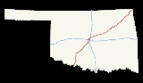
Interstate 44
runs diagonally through the U.S. state
of Oklahoma
, spanning from the Texas state line near Wichita Falls
to the Missouri border near Joplin
. It connects three of Oklahoma's largest cities, Oklahoma City
, Tulsa, and Lawton
. Most of I-44 in Oklahoma is a toll road
. In southwestern Oklahoma, I-44 is the H.E. Bailey Turnpike and follows a north–south direction. From Oklahoma City to Tulsa, I-44 follows the Turner Turnpike
As I-44 leaves Tulsa it becomes the Will Rogers Turnpike
to the Missouri border. In the Lawton, Oklahoma City, and Tulsa metro areas, I-44 is toll-free.
I-44 is parallel
ed by former US-66 (now mostly SH-66) from Oklahoma City to the Missouri state line.
. It is a freeway until Exit 5, which is the last free exit before the start of the southern section of the H.E. Bailey Turnpike. At Exit 30, the tolls end and I-44 becomes a freeway again through Lawton and Fort Sill
until Exit 46. The northern section of the H.E. Bailey Turnpike carries I-44 north, serving Chickasha
, before ending at U.S. Highway 62 (Exit 107) in Newcastle
.
From Newcastle, I-44 heads north through rural parts of Oklahoma City before serving as the western terminus of Interstate 240
. It then indirectly serves Will Rogers World Airport
by connecting to S.W. 59th St. (which becomes S.W. 54th St before reaching the airport) and SH-152, the Airport Road freeway. I-44 meets Interstate 40 west of downtown, at an interchange sometimes referred to as the Amarillo Junction. I-44 then passes west of the state fairgrounds and continues north to provide access to Bethany
and Warr Acres
. It then turns more eastbound to meet Interstate 35, which it overlaps to the Turner Turnpike interchange.
I-44 then follows the Turner Turnpike to Sapulpa
, where it becomes a freeway after meeting the Creek Turnpike
. I-44 bypasses downtown Tulsa; Interstate 244 serves the downtown areas. After meeting the Creek Turnpike again on the east side of the city, I-44 becomes a turnpike once again, gaining the Will Rogers Turnpike designation.
The Will Rogers Turnpike section serves many northeast Oklahoma towns, including Claremore
, Vinita
(where it passes under the world's largest McDonald's), and Miami
. After passing Miami, I-44 crosses the state line into Missouri.
and Will Rogers Turnpike
, with a western terminus at I-35 in Oklahoma City, the current western terminus of the Turner Turnpike.
I-44 was assigned to the H.E. Bailey Turnpike in 1982, when I-44 was assigned to the west and north legs of I-240 (then a semi-beltway around Oklahoma City) and the H.E. Bailey Turnpike as part of Oklahoma's "Diamond Jubilee" celebrations. Before I-44 was assigned to it, the freeway connector to the north end of the H.E. Bailey Turnpike was named the Will Rogers Expressway. The freeway section through Lawton was the Pioneer Expressway.
Interstate 44
Interstate 44 is a major highway in the central United States. Its western terminus is in Wichita Falls, Texas at a concurrency with US 277, US 281 and US 287; its eastern terminus is at the Illinois state line on the Poplar Street Bridge over the Mississippi River in St...
runs diagonally through the U.S. state
U.S. state
A U.S. state is any one of the 50 federated states of the United States of America that share sovereignty with the federal government. Because of this shared sovereignty, an American is a citizen both of the federal entity and of his or her state of domicile. Four states use the official title of...
of Oklahoma
Oklahoma
Oklahoma is a state located in the South Central region of the United States of America. With an estimated 3,751,351 residents as of the 2010 census and a land area of 68,667 square miles , Oklahoma is the 28th most populous and 20th-largest state...
, spanning from the Texas state line near Wichita Falls
Wichita Falls, Texas
Wichita Falls is a city in and the county seat of Wichita County, Texas, United States, United States. Wichita Falls is the principal city of the Wichita Falls Metropolitan Statistical Area, which encompasses all of Archer, Clay and Wichita counties. According to the U.S. Census estimate of 2010,...
to the Missouri border near Joplin
Joplin, Missouri
Joplin is a city in southern Jasper County and northern Newton County in the southwestern corner of the US state of Missouri. Joplin is the largest city in Jasper County, though it is not the county seat. As of the 2010 census, the city population was 50,150...
. It connects three of Oklahoma's largest cities, Oklahoma City
Oklahoma city
Oklahoma City is the capital and largest city of the U.S. state of Oklahoma.Oklahoma City may also refer to:*Oklahoma City metropolitan area*Downtown Oklahoma City*Uptown Oklahoma City*Oklahoma City bombing*Oklahoma City National Memorial...
, Tulsa, and Lawton
Lawton, Oklahoma
The city of Lawton is the county seat of Comanche County, in the U.S. state of Oklahoma. Located in the southwestern region of Oklahoma approximately southwest of Oklahoma City, it is the principal city of the Lawton Oklahoma Metropolitan Statistical Area...
. Most of I-44 in Oklahoma is a toll road
Toll road
A toll road is a privately or publicly built road for which a driver pays a toll for use. Structures for which tolls are charged include toll bridges and toll tunnels. Non-toll roads are financed using other sources of revenue, most typically fuel tax or general tax funds...
. In southwestern Oklahoma, I-44 is the H.E. Bailey Turnpike and follows a north–south direction. From Oklahoma City to Tulsa, I-44 follows the Turner Turnpike
Turner Turnpike
The Governor Roy J. Turner Turnpike is a toll road in central Oklahoma, connecting its two largest cities, Oklahoma City and Tulsa. It was authorized by the Oklahoma Legislature in 1947 and opened in May, 1953, it is the oldest of the state's ten turnpikes. The route is signed as Interstate 44 for...
As I-44 leaves Tulsa it becomes the Will Rogers Turnpike
Will Rogers Turnpike
The Will Rogers Turnpike is a toll road in northeast Oklahoma that runs from Tulsa, Oklahoma to the Missouri state line. It is long and costs $4.00 to drive one way...
to the Missouri border. In the Lawton, Oklahoma City, and Tulsa metro areas, I-44 is toll-free.
I-44 is parallel
Parallel (geometry)
Parallelism is a term in geometry and in everyday life that refers to a property in Euclidean space of two or more lines or planes, or a combination of these. The assumed existence and properties of parallel lines are the basis of Euclid's parallel postulate. Two lines in a plane that do not...
ed by former US-66 (now mostly SH-66) from Oklahoma City to the Missouri state line.
Route description
I-44 crosses the Red River near Burkburnett, TexasBurkburnett, Texas
Burkburnett is a city in Wichita County, Texas, United States. It is part of the Wichita Falls, Texas Metropolitan Statistical Area. The population was 10,927 at the 2000 census. The community's newspaper is the Burkburnett Informer/Star...
. It is a freeway until Exit 5, which is the last free exit before the start of the southern section of the H.E. Bailey Turnpike. At Exit 30, the tolls end and I-44 becomes a freeway again through Lawton and Fort Sill
Fort Sill
Fort Sill is a United States Army post near Lawton, Oklahoma, about 85 miles southwest of Oklahoma City.Today, Fort Sill remains the only active Army installation of all the forts on the South Plains built during the Indian Wars...
until Exit 46. The northern section of the H.E. Bailey Turnpike carries I-44 north, serving Chickasha
Chickasha, Oklahoma
Chickasha is a city in and the county seat, business and employment center of Grady County, Oklahoma, United States. The population was 15,850 at the 2000 census. Chickasha is home to the University of Science and Arts of Oklahoma and hosts an annual Festival of Light celebration located at...
, before ending at U.S. Highway 62 (Exit 107) in Newcastle
Newcastle, Oklahoma
Newcastle is the largest city in McClain County, Oklahoma, United States, and a part of the Oklahoma City Metropolitan Area. The population was 7,685 at the 2010 census.-Geography:Newcastle is located at ....
.
From Newcastle, I-44 heads north through rural parts of Oklahoma City before serving as the western terminus of Interstate 240
Interstate 240 (Oklahoma)
Interstate 240 is an Interstate Highway in Oklahoma, USA, that runs 16.22 miles west from Interstate 40 to Interstate 44 in southern Oklahoma City. After its terminus in southwest Oklahoma City, the main I-240 roadbed becomes Interstate 44 and Airport Road toward Will Rogers World Airport...
. It then indirectly serves Will Rogers World Airport
Will Rogers World Airport
Will Rogers World Airport , also known as Will Rogers Airport or simply Will Rogers, is located in southwestern Oklahoma City, Oklahoma 6 miles from downtown and is the principal commercial airport of the Oklahoma City Metropolitan Area...
by connecting to S.W. 59th St. (which becomes S.W. 54th St before reaching the airport) and SH-152, the Airport Road freeway. I-44 meets Interstate 40 west of downtown, at an interchange sometimes referred to as the Amarillo Junction. I-44 then passes west of the state fairgrounds and continues north to provide access to Bethany
Bethany, Oklahoma
Bethany is a city in Oklahoma County, Oklahoma, United States, and a part of the Oklahoma City metropolitan area. The population was 20,307 at the 2000 census.-Geography:Bethany is located at ....
and Warr Acres
Warr Acres, Oklahoma
Warr Acres is a city in Oklahoma County, Oklahoma, United States, and a part of the Oklahoma City metropolitan area. It was established after World War II by C.B. Warr, a dynamic businessman, builder, and commercial developer. The population was 9,735 at the 2000 census.-History:The Warr Acres...
. It then turns more eastbound to meet Interstate 35, which it overlaps to the Turner Turnpike interchange.
I-44 then follows the Turner Turnpike to Sapulpa
Sapulpa, Oklahoma
Sapulpa is a city in Creek and Tulsa counties in the U.S. state of Oklahoma. The population was 20,544 at the 2010 United States census, compared to 19,166 at the 2000 census...
, where it becomes a freeway after meeting the Creek Turnpike
Creek Turnpike
The Creek Turnpike is a partial beltway as a toll road around southern and eastern Tulsa, Oklahoma. It is long; its northern terminus is at the Will Rogers Turnpike, while the western terminus is at the Turner Turnpike...
. I-44 bypasses downtown Tulsa; Interstate 244 serves the downtown areas. After meeting the Creek Turnpike again on the east side of the city, I-44 becomes a turnpike once again, gaining the Will Rogers Turnpike designation.
The Will Rogers Turnpike section serves many northeast Oklahoma towns, including Claremore
Claremore, Oklahoma
Claremore is a city and the county seat of Rogers County, Oklahoma, United States. The population was 18,581 at the 2010 census, a 17.1 percent increase from 15,873 at the 2000 census. It is part of the Tulsa Metropolitan Area and home to Rogers State University...
, Vinita
Vinita, Oklahoma
Vinita is a city in south-central Craig County, Oklahoma. As of 2009, the population estimate was 6,057. It is the county seat of Craig County.-Geography:...
(where it passes under the world's largest McDonald's), and Miami
Miami, Oklahoma
Miami is a city in Ottawa County, Oklahoma, United States. As of 2009, the population estimate was 12,910. It is the county seat of Ottawa County. The city is named after the Miami tribe...
. After passing Miami, I-44 crosses the state line into Missouri.
History
I-44 was designated through Oklahoma to replace the section of US-66 running from Oklahoma City to Joplin, Missouri. I-44 covered the already-existing Turner TurnpikeTurner Turnpike
The Governor Roy J. Turner Turnpike is a toll road in central Oklahoma, connecting its two largest cities, Oklahoma City and Tulsa. It was authorized by the Oklahoma Legislature in 1947 and opened in May, 1953, it is the oldest of the state's ten turnpikes. The route is signed as Interstate 44 for...
and Will Rogers Turnpike
Will Rogers Turnpike
The Will Rogers Turnpike is a toll road in northeast Oklahoma that runs from Tulsa, Oklahoma to the Missouri state line. It is long and costs $4.00 to drive one way...
, with a western terminus at I-35 in Oklahoma City, the current western terminus of the Turner Turnpike.
I-44 was assigned to the H.E. Bailey Turnpike in 1982, when I-44 was assigned to the west and north legs of I-240 (then a semi-beltway around Oklahoma City) and the H.E. Bailey Turnpike as part of Oklahoma's "Diamond Jubilee" celebrations. Before I-44 was assigned to it, the freeway connector to the north end of the H.E. Bailey Turnpike was named the Will Rogers Expressway. The freeway section through Lawton was the Pioneer Expressway.
Exit list
| County | Location | Mile | # Exit number An exit number is a number assigned to a road junction, usually an exit from a freeway. It is usually marked on the same sign as the destinations of the exit, as well as a sign in the gore.... |
Destinations | Notes |
|---|---|---|---|---|---|
| Cotton Cotton County, Oklahoma Cotton County is a county located in the U.S. state of Oklahoma. As of 2000, the population was 6,614. Its county seat is Walters.When Oklahoma achieved statehood in 1907, the area which is now Cotton County fell within the boundaries of Comanche County... |
1 | ||||
| 5 | East end of US-277/US-281 overlap | ||||
| South end of H. E. Bailey Turnpike H. E. Bailey Turnpike The H. E. Bailey Turnpike is a toll road in southwestern region of the U.S. state of Oklahoma. The route, opened on April 23, 1964, is a four-lane limited access highway that connects Oklahoma City to Lawton in its northern section and Lawton to Wichita Falls along its southern section. The... |
|||||
| Walters | 20 | Toll plaza is located at this interchange | |||
| Comanche Comanche County, Oklahoma Comanche County is a county located in the U.S. state of Oklahoma. Built on former reservation lands of the Comanche, Kiowa, and Apache in Indian Territory, Comanche County was open for settlement on August 16, 1901 by lottery. The region has three cities and seven towns as well as the Fort Sill... |
30 | West end of US-277/US-281 overlap | |||
| Lawton Lawton, Oklahoma The city of Lawton is the county seat of Comanche County, in the U.S. state of Oklahoma. Located in the southwestern region of Oklahoma approximately southwest of Oklahoma City, it is the principal city of the Lawton Oklahoma Metropolitan Statistical Area... |
33 | ||||
| 36A | Signed as exits 36A (east) and 36B (west) westbound | ||||
| 37 | Gore Boulevard | ||||
| 39B | Westbound exit and eastbound entrance | ||||
| 39A | Cache Road – Lawton Business District | Former US-62 west | |||
| 40A | Signed as exits 40A (east) and 40B (west) westbound | ||||
| Fort Sill Fort Sill Fort Sill is a United States Army post near Lawton, Oklahoma, about 85 miles southwest of Oklahoma City.Today, Fort Sill remains the only active Army installation of all the forts on the South Plains built during the Indian Wars... |
|||||
| 40C | Gate 2 | closed | |||
| 41 | Fort Sill Fort Sill Fort Sill is a United States Army post near Lawton, Oklahoma, about 85 miles southwest of Oklahoma City.Today, Fort Sill remains the only active Army installation of all the forts on the South Plains built during the Indian Wars... Key Gate |
||||
| 45 | |||||
| 46 | Eastbound exit and westbound entrance; east end of US-62/US-277/US-281 overlap | ||||
| Elgin Elgin, Oklahoma Elgin is a city in Comanche County, Oklahoma, United States. The population was 2,156 at the 2010 census. It is included in the Lawton, Oklahoma Metropolitan Statistical Area.-Geography:Elgin is located at .... |
53 | ||||
| 62 | Fletcher Fletcher, Oklahoma Fletcher is a town in Comanche County, Oklahoma, United States. The population was 1,177 at the 2010 census. It is included in the Lawton, Oklahoma Metropolitan Statistical Area.-Geography:Fletcher is located at .... , Cyril Cyril, Oklahoma Cyril is a town in Caddo County, Oklahoma, United States. The population was 1,168 at the 2000 census.-Geography:Cyril is located at .According to the United States Census Bureau, the town has a total area of , all of it land.... , Sterling Sterling, Oklahoma Sterling is a town in Comanche County, Oklahoma, United States. The population was 793 at the 2010 census. It is part of the Lawton Metropolitan Statistical Area.-Geography:Sterling is located at .... |
Westbound exit and eastbound entrance | |||
| Grady Grady County, Oklahoma Grady County is a county located in the U.S. state of Oklahoma. As of 2006, the population was 50,490. Its county seat is Chickasha.Grady County is part of the Oklahoma City Metropolitan Statistical Area.-History:... |
Toll plaza | ||||
| Chickasha Chickasha, Oklahoma Chickasha is a city in and the county seat, business and employment center of Grady County, Oklahoma, United States. The population was 15,850 at the 2000 census. Chickasha is home to the University of Science and Arts of Oklahoma and hosts an annual Festival of Light celebration located at... |
80 | ||||
| 83 | |||||
| Toll plaza | |||||
| 99A | H. E. Bailey Spur – Blanchard Blanchard, Oklahoma Blanchard is a city in Grady and McClain counties in the U.S. state of Oklahoma. The population was 7,670 at the 2010 census. Blanchard is part of a rapidly growing area of northern McClain and Grady Counties known as the "Tri-City Area" with Newcastle and Tuttle.-Early history:Blanchard is... , Norman Norman, Oklahoma Norman is a city in Cleveland County, Oklahoma, United States, and is located south of downtown Oklahoma City. It is part of the Oklahoma City metropolitan area. As of the 2010 census, Norman was to have 110,925 full-time residents, making it the third-largest city in Oklahoma and the... |
||||
| 99B | |||||
| McClain McClain County, Oklahoma McClain County is a county located in the U.S. state of Oklahoma. The population was 27,740 at the 2000 census. Its county seat is Purcell. McClain County is part of the Oklahoma City Metropolitan Statistical Area, and is in the top 3 fastest growing counties in Oklahoma with a growth rate of... |
|||||
| North end of H. E. Bailey Turnpike H. E. Bailey Turnpike The H. E. Bailey Turnpike is a toll road in southwestern region of the U.S. state of Oklahoma. The route, opened on April 23, 1964, is a four-lane limited access highway that connects Oklahoma City to Lawton in its northern section and Lawton to Wichita Falls along its southern section. The... |
|||||
| Newcastle Newcastle, Oklahoma Newcastle is the largest city in McClain County, Oklahoma, United States, and a part of the Oklahoma City Metropolitan Area. The population was 7,685 at the 2010 census.-Geography:Newcastle is located at .... |
107 | West end of US-62 overlap | |||
| 108 | West end of SH-37 overlap | ||||
| 108A | Frontage Road | Westbound exit and eastbound entrance | |||
| Cleveland Cleveland County, Oklahoma Cleveland County is a county in the central part of the U.S. state of Oklahoma. The population was 255,755 at the 2010 census. Its county seat is Norman. Cleveland County is part of the Oklahoma City Metropolitan Statistical Area.-History:... |
Oklahoma City Oklahoma City, Oklahoma Oklahoma City is the capital and the largest city in the state of Oklahoma. The county seat of Oklahoma County, the city ranks 31st among United States cities in population. The city's population, from the 2010 census, was 579,999, with a metro-area population of 1,252,987 . In 2010, the Oklahoma... |
109 | Southwest 149th Street | ||
| 110 | East end of SH-37 overlap | ||||
| 111 | Southwest 119th Street | ||||
| 112 | Southwest 104th Street | ||||
| Oklahoma Oklahoma County, Oklahoma Oklahoma County is a county located in the central partof the U.S. state of Oklahoma. The population was 718,633 at the 2010 census. The county seat and principal city is Oklahoma City... |
113 | Southwest 89th Street | |||
| 114 | Southwest 74th Street | ||||
| 115 | – Dallas, Fort Smith | East end of US-62 overlap; west end of SH-3 overlap; no exit number westbound | |||
| 116A | Southwest 59th Street | ||||
| 116B | |||||
| 117A | Southwest 44th Street | Signed as exit 117B westbound | |||
| 118 | Southwest 29th Street | Former SH-152 | |||
| 119 | Southwest 15th Street | ||||
| 120 | – Amarillo, Fort Smith | Signed as exits 120A (west) and 120B (east) | |||
| 121 | Northwest 10th Street – Fair Park Fair Park Dallas Fair Park is a recreational and educational complex located in Dallas, Texas . The complex is registered as a Dallas Landmark, National Historic Landmark and is home to nine museums, six performance facilities, a lagoon, and the largest Ferris wheel in North America... |
Signed as exits 121A (east) and 121B (west) | |||
| 122 | Northwest 23rd Street | ||||
| 123A | Northwest 36th Street | Eastbound exit and westbound entrance | |||
| East end of SH-3 overlap | |||||
| 123B | West end of SH-66 overlap; Former US-66 U.S. Route 66 in Oklahoma The historic U.S. Route 66 ran from west to northeast across the U.S. state of Oklahoma, along the path now taken by Interstate 40 and State Highway 66. It passed through Oklahoma City, Tulsa, and many smaller communities. West of the Oklahoma City area, it has been largely replaced by I-40; the... |
||||
| 124 | North May Avenue | ||||
| 125A | North Penn Avenue | ||||
| 125B | Classen Boulevard | ||||
| 125C | Eastbound exit is via exit 125A | ||||
| 126 | Western Avenue | ||||
| 127 | , Edmond | ||||
| 128A | Lincoln Boulevard – State Capitol | ||||
| 128B | Kelley Avenue | ||||
| 129 | M.L. King Avenue | ||||
| 130 | , Dallas | West end of I-35 overlap; no exit number westbound | |||
| 134 | Wilshire Boulevard | ||||
| 135 | Britton Road | ||||
| 136 | Hefner Road | ||||
| 137 | Northeast 122nd Street | ||||
| , Wichita | East end of I-35/SH-66 overlap | ||||
| 138B | Kilpatrick Turnpike | No exit number westbound | |||
| Lincoln Lincoln County, Oklahoma Lincoln County is a county located in the U.S. state of Oklahoma. The population as of 2010 was 34,273. It is part of the Oklahoma City Metropolitan Statistical Area.Its county seat is Chandler.... |
|||||
| South/west end of Turner Turnpike Turner Turnpike The Governor Roy J. Turner Turnpike is a toll road in central Oklahoma, connecting its two largest cities, Oklahoma City and Tulsa. It was authorized by the Oklahoma Legislature in 1947 and opened in May, 1953, it is the oldest of the state's ten turnpikes. The route is signed as Interstate 44 for... |
|||||
| 146 | Luther Luther, Oklahoma Luther is a town in Oklahoma County, Oklahoma, United States, and a part of the Oklahoma City Metropolitan Area. The population was 612 at the 2000 census.-Geography:Luther is located at .... /Jones Jones, Oklahoma Jones is a town in Oklahoma County, Oklahoma, United States, and a part of the Oklahoma City Metropolitan Area. The population was 2,517 at the 2000 census.-Early History:... |
Westbound Entrance/Eastbound Exit | |||
| Wellston | 158 | Former US-66 U.S. Route 66 in Oklahoma The historic U.S. Route 66 ran from west to northeast across the U.S. state of Oklahoma, along the path now taken by Interstate 40 and State Highway 66. It passed through Oklahoma City, Tulsa, and many smaller communities. West of the Oklahoma City area, it has been largely replaced by I-40; the... |
|||
| Chandler | 166 | ||||
| Stroud | 179 | ||||
| Creek Creek County, Oklahoma Creek County is a county located in the U.S. state of Oklahoma. As of 2010, the population was 69,967. Its county seat is Sapulpa.-Geography:According to the U.S. Census Bureau, the county has a total area of , of which is land and is water.... |
Toll plaza | ||||
| Bristow | 196 | Former US-66 U.S. Route 66 in Oklahoma The historic U.S. Route 66 ran from west to northeast across the U.S. state of Oklahoma, along the path now taken by Interstate 40 and State Highway 66. It passed through Oklahoma City, Tulsa, and many smaller communities. West of the Oklahoma City area, it has been largely replaced by I-40; the... |
|||
| 211 | Former US-66 U.S. Route 66 in Oklahoma The historic U.S. Route 66 ran from west to northeast across the U.S. state of Oklahoma, along the path now taken by Interstate 40 and State Highway 66. It passed through Oklahoma City, Tulsa, and many smaller communities. West of the Oklahoma City area, it has been largely replaced by I-40; the... |
||||
| Sapulpa | 215 | ||||
| 218A | |||||
| North/east end of Turner Turnpike Turner Turnpike The Governor Roy J. Turner Turnpike is a toll road in central Oklahoma, connecting its two largest cities, Oklahoma City and Tulsa. It was authorized by the Oklahoma Legislature in 1947 and opened in May, 1953, it is the oldest of the state's ten turnpikes. The route is signed as Interstate 44 for... |
|||||
| 218 | Creek Turnpike Creek Turnpike The Creek Turnpike is a partial beltway as a toll road around southern and eastern Tulsa, Oklahoma. It is long; its northern terminus is at the Will Rogers Turnpike, while the western terminus is at the Turner Turnpike... east |
Eastbound exit and westbound entrance | |||
| Tulsa Tulsa County, Oklahoma Tulsa County is a county located in the U.S. state of Oklahoma. According to the 2010 U.S. Census, the population is 603,403. Its county seat is Tulsa.-History of Tulsa County:The history of Tulsa County greatly overlaps the history of the city of Tulsa... |
221A | 57th West Avenue | Westbound exit only | ||
| 221B | Westbound exit and eastbound entrance; west end of SH-66 overlap | ||||
| 222A | 49th West Avenue | ||||
| 222C | 56th Street | Westbound exit only | |||
| 222B | 55th Place | Eastbound exit only | |||
| 223A | |||||
| 223B | 51st Street (via Gilcrease Expressway Gilcrease Expressway The Gilcrease Expressway is a highway in Tulsa County, Oklahoma's overall, long-term plan to complete an outer highway loop around Tulsa's central business district. The highway will connect Interstate 44 in West Tulsa to Interstate 244 near the Tulsa International Airport.-Route... ) |
Signed as exit 1B eastbound | |||
| Tulsa Tulsa, Oklahoma Tulsa is the second-largest city in the state of Oklahoma and 46th-largest city in the United States. With a population of 391,906 as of the 2010 census, it is the principal municipality of the Tulsa Metropolitan Area, a region with 937,478 residents in the MSA and 988,454 in the CSA. Tulsa's... |
223C | 33rd West Avenue | |||
| 224 | Union Avenue | ||||
| 224 | |||||
| 225 | Elwood Avenue | Eastbound exit is part of exit 224 | |||
| 226A | Riverside Drive | ||||
| 226B | Peoria Avenue | ||||
| 227 | Lewis Avenue | ||||
| 228 | Harvard Avenue | ||||
| 229 | Yale Avenue | ||||
| 230 | 41st Street, Sheridan Road | ||||
| 231 | |||||
| 232 | East 31st Street, Memorial Drive | Eastbound exit is part of exit 231 | |||
| 233 | East 21st Street | Signed as exit 233B westbound | |||
| 234A | No eastbound exit to US-169 south, use exit 231 | ||||
| 234B | Garnett Road | Eastbound exit and westbound entrance | |||
| 235 | East 11th Street | Former US-66 U.S. Route 66 in Oklahoma The historic U.S. Route 66 ran from west to northeast across the U.S. state of Oklahoma, along the path now taken by Interstate 40 and State Highway 66. It passed through Oklahoma City, Tulsa, and many smaller communities. West of the Oklahoma City area, it has been largely replaced by I-40; the... |
|||
| 236 | 129th East Avenue | ||||
| 236B | Westbound exit and eastbound entrance; west end of US-412 overlap | ||||
| Rogers Rogers County, Oklahoma Rogers County is a county located in the U.S. state of Oklahoma. As of 2010, the population was 86,905. Its county seat is Claremore. The county was originally created in 1906 and named Cooweescoowee... |
238 | 161st East Avenue | |||
| 240 | |||||
| 241 | No eastbound entrance; east end of SH-66 overlap; no exit number westbound | ||||
| 33A | , Siloam Springs | East end of US-412 overlap; no exit number eastbound | |||
| Creek Turnpike Creek Turnpike The Creek Turnpike is a partial beltway as a toll road around southern and eastern Tulsa, Oklahoma. It is long; its northern terminus is at the Will Rogers Turnpike, while the western terminus is at the Turner Turnpike... west – Oklahoma City |
|||||
| South/west end of Will Rogers Turnpike Will Rogers Turnpike The Will Rogers Turnpike is a toll road in northeast Oklahoma that runs from Tulsa, Oklahoma to the Missouri state line. It is long and costs $4.00 to drive one way... |
|||||
| 35 | East Pine Street | Westbound exit and eastbound entrance | |||
| 248 | To Former US-66 U.S. Route 66 in Oklahoma The historic U.S. Route 66 ran from west to northeast across the U.S. state of Oklahoma, along the path now taken by Interstate 40 and State Highway 66. It passed through Oklahoma City, Tulsa, and many smaller communities. West of the Oklahoma City area, it has been largely replaced by I-40; the... |
||||
| 255 | |||||
| Mayes Mayes County, Oklahoma Mayes County is a county located in the U.S. state of Oklahoma. It was named for Samuel Houston Mayes, Principal Chief of the Cherokee Nation from 1895 to 1899. According to the 2010 census the population was 41,259, a 7.5 percent increase from 2000, when the population was 38,369... |
269 | Eastbound exit and westbound entrance | |||
| Craig Craig County, Oklahoma Craig County is a county located in the U.S. state of Oklahoma. As of 2010, the population was 15,029, a gain of 0.5 percent from 14,950 in 2000. Its county seat is Vinita.Craig County was organized in 1907.-History:... |
Big Cabin | 283 | |||
| Toll plaza | |||||
| Vinita | 289 | Former US-66 U.S. Route 66 in Oklahoma The historic U.S. Route 66 ran from west to northeast across the U.S. state of Oklahoma, along the path now taken by Interstate 40 and State Highway 66. It passed through Oklahoma City, Tulsa, and many smaller communities. West of the Oklahoma City area, it has been largely replaced by I-40; the... |
|||
| Ottawa Ottawa County, Oklahoma Ottawa County is a county located in the U.S. state of Oklahoma. As of 2000, the population was 33,194. Its county seat is Miami. It was named for the Ottawa Tribe of Oklahoma.Ottawa County was established in 1907.-Geography:... |
302 | US-59 (US-69) is former US-66 U.S. Route 66 in Oklahoma The historic U.S. Route 66 ran from west to northeast across the U.S. state of Oklahoma, along the path now taken by Interstate 40 and State Highway 66. It passed through Oklahoma City, Tulsa, and many smaller communities. West of the Oklahoma City area, it has been largely replaced by I-40; the... |
|||
| Miami | 313 | ||||
| North/east end of Will Rogers Turnpike Will Rogers Turnpike The Will Rogers Turnpike is a toll road in northeast Oklahoma that runs from Tulsa, Oklahoma to the Missouri state line. It is long and costs $4.00 to drive one way... |
|||||