

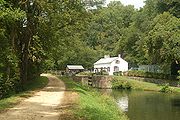
Locks on the C&O Canal
Encyclopedia
Lock (water transport)
A lock is a device for raising and lowering boats between stretches of water of different levels on river and canal waterways. The distinguishing feature of a lock is a fixed chamber in which the water level can be varied; whereas in a caisson lock, a boat lift, or on a canal inclined plane, it is...
on the C&O Canal
Chesapeake and Ohio Canal
The Chesapeake and Ohio Canal, abbreviated as the C&O Canal, and occasionally referred to as the "Grand Old Ditch," operated from 1831 until 1924 parallel to the Potomac River in Maryland from Cumberland, Maryland to Washington, D.C. The total length of the canal is about . The elevation change of...
, located in Maryland
Maryland
Maryland is a U.S. state located in the Mid Atlantic region of the United States, bordering Virginia, West Virginia, and the District of Columbia to its south and west; Pennsylvania to its north; and Delaware to its east...
, West Virginia
West Virginia
West Virginia is a state in the Appalachian and Southeastern regions of the United States, bordered by Virginia to the southeast, Kentucky to the southwest, Ohio to the northwest, Pennsylvania to the northeast and Maryland to the east...
, and Washington, D.C.
Washington, D.C.
Washington, D.C., formally the District of Columbia and commonly referred to as Washington, "the District", or simply D.C., is the capital of the United States. On July 16, 1790, the United States Congress approved the creation of a permanent national capital as permitted by the U.S. Constitution....
of the United States
United States
The United States of America is a federal constitutional republic comprising fifty states and a federal district...
, were numbered from 1 to 75 with two locks
Lock (water transport)
A lock is a device for raising and lowering boats between stretches of water of different levels on river and canal waterways. The distinguishing feature of a lock is a fixed chamber in which the water level can be varied; whereas in a caisson lock, a boat lift, or on a canal inclined plane, it is...
, 63⅓ and 64⅔, having fractional numbers and no lock 65. There is also a lock at the downstream end of the canal in Washington, DC where Rock Creek
Rock Creek
-Streams:* Rock Creek * Rock Creek , disambiguation* Rock Creek * Rock Creek , in Illinois* Rock Creek , in Maryland and the District of Columbia* Rock Creek , in Missoula County...
flows into the Potomac River
Potomac River
The Potomac River flows into the Chesapeake Bay, located along the mid-Atlantic coast of the United States. The river is approximately long, with a drainage area of about 14,700 square miles...
which is sometimes called Lock 0 or the Tidewater Lock
Tidewater Lock
The Tidewater Lock is a dam in Washington, D.C. to the west of the mouth of Rock Creek at the Potomac River, on the east side of Georgetown. It is sometimes listed as Lock 0 on the Chesapeake and Ohio Canal....
.
Some of the locks were also informally named, usually after a prominent lockkeeper, a nearby town or important geographical feature. Some locks are known by more than one name and some are only known by their number.
With respect to the fractional locks, it was found that the level of the canal between locks 62 and 66 could be raised in three steps instead of four. So the additional locks through there were numbered 1⅓ steps apart (62, 63⅓, 64⅔ and 66) so that the other locks on the canal did not have to be renumbered.
.jpg)
| Lock | Miles | Name | Nearby landmarks | Coordinates |
|---|---|---|---|---|
| 0 | 0.0 | Tidewater Lock Tidewater Lock The Tidewater Lock is a dam in Washington, D.C. to the west of the mouth of Rock Creek at the Potomac River, on the east side of Georgetown. It is sometimes listed as Lock 0 on the Chesapeake and Ohio Canal.... |
38.900°N 77.058°W | |
| 1 | 0.38 | Georgetown Georgetown, Washington, D.C. Georgetown is a neighborhood located in northwest Washington, D.C., situated along the Potomac River. Founded in 1751, the port of Georgetown predated the establishment of the federal district and the City of Washington by 40 years... |
38.904°N 77.058°W | |
| 2 | 0.42 | Georgetown Georgetown, Washington, D.C. Georgetown is a neighborhood located in northwest Washington, D.C., situated along the Potomac River. Founded in 1751, the port of Georgetown predated the establishment of the federal district and the City of Washington by 40 years... |
38.904°N 77.059°W | |
| 3 | 0.49 | Georgetown Georgetown, Washington, D.C. Georgetown is a neighborhood located in northwest Washington, D.C., situated along the Potomac River. Founded in 1751, the port of Georgetown predated the establishment of the federal district and the City of Washington by 40 years... |
38.904°N 77.059°W | |
| 4 | 0.54 | Georgetown Georgetown, Washington, D.C. Georgetown is a neighborhood located in northwest Washington, D.C., situated along the Potomac River. Founded in 1751, the port of Georgetown predated the establishment of the federal district and the City of Washington by 40 years... |
38.904°N 77.061°W | |
| 5 | 5.0 | Brookmont Lock | Brookmont Brookmont, Maryland Brookmont is a census-designated place and an unincorporated area in Montgomery County, Maryland, United States.-Geography:As an unincorporated area, Brookmont's boundaries are not officially defined... |
38.940°N 77.122°W |
| 6 | 5.4 | Magazine Lock | Little Falls | 38.945°N 77.124°W |
| 7 | 7.0 | Chataqua Lock | Glen Echo Glen Echo, Maryland Glen Echo is a town in Montgomery County, Maryland, United States, that was chartered in 1904. The population was 242 at the 2000 census.Glen Echo derives its name from Edward and Edwin Baltzley, who came up with name circa 1888... |
38.965°N 77.139°W |
| 8 | 8.33 | Seven Locks 1 | 38.971°N 77.161°W | |
| 9 | 8.7 | Seven Locks 2 | 38.972°N 77.167°W | |
| 10 | 8.79 | Seven Locks 3 | 38.972°N 77.169°W | |
| 11 | 8.97 | Seven Locks 4 | 38.972°N 77.172°W | |
| 12 | 9.29 | Seven Locks 5 | 38.972°N 77.178°W | |
| 13 | 9.37 | Seven Locks 6 | American Legion (Cabin John) Bridge American Legion Memorial Bridge (Potomac River) The American Legion Memorial Bridge, also known as the American Legion Bridge and formerly as the Cabin John Bridge, is a bridge in Montgomery County, Maryland, United States. It carries the Capital Beltway across the Potomac River between Montgomery County and Fairfax County, Virginia... |
38.972°N 77.179°W |
| 14 | 9.47 | Seven Locks 7 | 38.972°N 77.181°W | |
| 15 | 13.45 | Six Locks 1 | Great Falls Great Falls of the Potomac River The Great Falls of the Potomac River are located at the fall line of the Potomac River, upstream from Washington, D.C. Great Falls Park, operated by the National Park Service, is located on the southern banks in Virginia, while Chesapeake and Ohio Canal parkland is located along the northern banks... |
38.989°N 77.244°W |
| 16 | 13.60 | Six Locks 2 | Great Falls Great Falls of the Potomac River The Great Falls of the Potomac River are located at the fall line of the Potomac River, upstream from Washington, D.C. Great Falls Park, operated by the National Park Service, is located on the southern banks in Virginia, while Chesapeake and Ohio Canal parkland is located along the northern banks... |
38.992°N 77.245°W |
| 17 | 13.99 | Six Locks 3 | Great Falls Great Falls of the Potomac River The Great Falls of the Potomac River are located at the fall line of the Potomac River, upstream from Washington, D.C. Great Falls Park, operated by the National Park Service, is located on the southern banks in Virginia, while Chesapeake and Ohio Canal parkland is located along the northern banks... |
38.996°N 77.248°W |
| 18 | 13.99 | Six Locks 4 | Great Falls Great Falls of the Potomac River The Great Falls of the Potomac River are located at the fall line of the Potomac River, upstream from Washington, D.C. Great Falls Park, operated by the National Park Service, is located on the southern banks in Virginia, while Chesapeake and Ohio Canal parkland is located along the northern banks... |
38.998°N 77.249°W |
| 19 | 14.17 | Six Locks 5 | Great Falls Great Falls of the Potomac River The Great Falls of the Potomac River are located at the fall line of the Potomac River, upstream from Washington, D.C. Great Falls Park, operated by the National Park Service, is located on the southern banks in Virginia, while Chesapeake and Ohio Canal parkland is located along the northern banks... |
38.999°N 77.248°W |
| 20 | 14.30 | Six Locks 6 - aka Tavern Lock | Great Falls Tavern | 39.000°N 77.248°W |
| 21 | 16.64 | Swain's Lock | 39.032°N 77.244°W | |
| 22 | 19.63 | Pennyfield Lock | 39.054°N 77.289°W | |
| 23 | 22.12 | Violette's Lock and Inlet Lock 2 | 39.067°N 77.329°W | |
| 24 | 23.00 | Riley's Lock | Seneca Creek Aqueduct Seneca Creek (Potomac River) Seneca Creek is a stream in Montgomery County, Maryland, roughly northwest of Washington, D.C. It drains to the Potomac River.-Course:The creek begins with two main tributaries:... |
39.069°N 77.340°W |
| 25 | 30.8 | Edward's Ferry | Poolesville | 39.103°N 77.472°W |
| 26 | 39.4 | Wood's Lock | 39.216°N 77.458°W | |
| 27 | 41.5 | Spinks Ferry | Monocacy Aqueduct Monocacy Aqueduct The Monocacy Aqueduct — or C&O Canal Aqueduct No. 2 — is the largest aqueduct on the Chesapeake and Ohio Canal, crossing the Monocacy River just before it empties into the Potomac River in Frederick County, Maryland, USA... |
39.191°N 77.471°W |
| 28 | 48.9 | Fulton's Lock | Point of Rocks Point of Rocks, Maryland Point of Rocks is a community in Frederick County, Maryland. It is named for the striking rock formation on the adjacent Catoctin Mountain, which were formed by the Potomac River cutting through the ridge in a water gap, a typical formation in the Ridge-and-Valley Appalachians... |
39.282°N 77.548°W |
| 29 | 50.89 | Lander Lock or Catoctin Lock | 39.307°N 77.559°W | |
| 30 | 55.0 | Brunswick, Maryland Brunswick, Maryland Brunswick is a city in Frederick County, Maryland, United States. The population was 5,870 at the 2010 census.- History :The area now known as Brunswick was originally home to the Susquehanna Indians. In 1728 the first settlement was built, and the region became known as Eel Town, because the... |
39.311°N 77.630°W | |
| 31 | 58.0 | Weverton Lock | 39.329°N 77.681°W | |
| 32 | 60.23 | Sandy Hook, Maryland Sandy Hook, Maryland Sandy Hook is an unincorporated community in Washington County, Maryland, United States.-References:... |
39.324°N 77.719°W | |
| 33 | 60.7 | Harper's Ferry | 39.325°N 77.727°W | |
| 34 | 61.57 | Goodheart's Lock | Harper's Ferry | 39.333°N 77.739°W |
| 35 | 62.33 | Harper's Ferry | 39.337°N 77.751°W | |
| 36 | 62.44 | Harper's Ferry | 39.337°N 77.753°W | |
| 37 | 66.96 | Mountain Lock | 39.385°N 77.735°W | |
| 38 | 72.65 | Shepherdstown Lock | Shepherdstown, West Virginia Shepherdstown, West Virginia Shepherdstown is a town in Jefferson County, West Virginia, United States, located along the Potomac River. It is the oldest town in the state, having been chartered in 1762 by Colonial Virginia's General Assembly. Since 1863, Shepherdstown has been in West Virginia, and is the oldest town in... |
39.435°N 77.798°W |
| 39 | 74.0 | One Mile Lock | James Rumsey Bridge, Snyder's Landing | 39.446°N 77.783°W |
| 40 | 79.41 | Horseshoe Bend | 39.486°N 77.779°W | |
| 41 | 88.9 | 39.533°N 77.838°W | ||
| 42 | 89.04 | 39.532°N 77.840°W | ||
| 43 | 92.96 | 39.542°N 77.866°W | ||
| 44 | 99.3 | Williamsport | Williamsport, Maryland Williamsport, Maryland Williamsport is a town in Washington County, Maryland, United States. The population was 1,868 at the 2000 census and 2,278 as of July 2008.-Geography: Williamsport is located at .... |
39.594°N 77.825°W |
| 45 | 107.27 | Two Locks 1 | 39.614°N 77.926°W | |
| 46 | 107.42 | Two Locks 2 | 39.616°N 77.927°W | |
| 47 | 108.8 | Four Locks 1 | 39.617°N 77.947°W | |
| 48 | 108.8 | Four Locks 2 | 39.616°N 77.948°W | |
| 49 | 108.8 | Four Locks 3 | 39.615°N 77.949°W | |
| 50 | 108.8 | Four Locks 4 | 39.614°N 77.949°W | |
| 51 | 122.59 | Hancock 1 | Hancock, Maryland Hancock, Maryland Hancock is a town in Washington County, Maryland, United States. The population was 1,725 at the 2000 census. The Western Maryland community is notable for being located at the narrowest part of the state... |
39.693°N 78.151°W |
| 52 | 122.85 | Hancock 2 | Hancock, Maryland Hancock, Maryland Hancock is a town in Washington County, Maryland, United States. The population was 1,725 at the 2000 census. The Western Maryland community is notable for being located at the narrowest part of the state... |
39.694°N 78.156°W |
| 53 | 130.0 | Irishman's Lock | Leopard's Mill | 39.651°N 78.241°W |
| 54 | 134.0 | 39.624°N 78.289°W | ||
| 55 | 134.0 | Near Dam 6 | 39.625°N 78.292°W | |
| 56 | 136.2 | Sideling Lock | Sideling Hill Sideling Hill Sideling Hill is a long, steep, narrow mountain ridge in the Ridge-and-Valley physiographic province of the Appalachian Mountains, located in Washington County in western Maryland and adjacent West Virginia and Pennsylvania, USA... |
39.637°N 78.329°W |
| 57 | 139.2 | 39.627°N 78.361°W | ||
| 58 | 143.9 | 39.621°N 78.406°W | ||
| 59 | 146.6 | 39.611°N 78.433°W | ||
| 60 | 149.7 | Stickpile Hill | 39.582°N 78.404°W | |
| 61 | 153.1 | 39.584°N 78.460°W | ||
| 62 | 154.2 | 39.571°N 78.453°W | ||
| 63⅓ | 154.5 | Paw Paw Tunnel Paw Paw Tunnel The Paw Paw Tunnel is a long canal tunnel on the Chesapeake and Ohio Canal in Allegany County, Maryland. Located near Paw Paw, West Virginia, it was built to bypass the Paw-Paw Bends, a six-mile stretch of the Potomac River containing five horseshoe bends... |
39.567°N 78.454°W | |
| 64⅔ | 154.6 | 39.566°N 78.455°W | ||
| 66 | 154.7 | 39.565°N 78.457°W | ||
| 67 | 161.8 | Darkey's Lock | 39.525°N 78.533°W | |
| 68 | 164.8 | Crabtree's Lock | 39.530°N 78.589°W | |
| 69 | 166.4 | Twigg's Lock | 39.540°N 78.608°W | |
| 70 | 166.7 | Oldtown | 39.540°N 78.612°W | |
| 71 | 167.0 | 39.541°N 78.618°W | ||
| 72 | 174.4 | The Narrows or Ten Mile Lock | 39.575°N 78.730°W | |
| 73 | 175.4 | North Branch 1 | 39.588°N 78.736°W | |
| 74 | 175.5 | North Branch 2 | 39.588°N 78.738°W | |
| 75 | 175.6 | North Branch 3 | 39.587°N 78.741°W | |
| 184.5 | End of the canal | Cumberland, Maryland Cumberland, Maryland Cumberland is a city in the far western, Appalachian portion of Maryland, United States. It is the county seat of Allegany County, and the primary city of the Cumberland, MD-WV Metropolitan Statistical Area. At the 2010 census, the city had a population of 20,859, and the metropolitan area had a... |
39.649°N 78.763°W |