
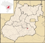
Cristianópolis
Encyclopedia
| Cristianópolis | |
|---|---|
| State | Goiás Goiás Goiás is a state of Brazil, located in the central part of the country. The name Goiás comes from the name of an indigenous community... |
| Coordinates: | 17°11′56"S 48°41′53"W |
| Area: | 225.3 km² |
| Population: | 3,041 (IBGE 2007) |
| Elevation: | 802 m above sea level |
| Postcode (CEP): | 75230-000 |
| Became a city: | 1953 |
| Distance to Goiânia Goiânia -Climate:The city has a tropical wet and dry climate with an average temperature of . There's a wet season, from October to April, and a dry one, from May to September. Annual rainfall is around 1,520 mm.... : |
268 km. |
| IBGE statistical microregion: | Pires do Rio Microregion Pires do Rio Microregion The Pires do Rio Microregion is a statistical region of south-central Goiás state, Brazil. The most important city is Pires do Rio. The area includes 10 cities with a population of 90,327 in an area of 9,449.80 km²... |
| Website: | n/a |
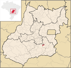
Cristianópolis is a small town
Town
A town is a human settlement larger than a village but smaller than a city. The size a settlement must be in order to be called a "town" varies considerably in different parts of the world, so that, for example, many American "small towns" seem to British people to be no more than villages, while...
and municipality
Municipality
A municipality is essentially an urban administrative division having corporate status and usually powers of self-government. It can also be used to mean the governing body of a municipality. A municipality is a general-purpose administrative subdivision, as opposed to a special-purpose district...
in south-eastern Goiás
Goiás
Goiás is a state of Brazil, located in the central part of the country. The name Goiás comes from the name of an indigenous community...
state, Brazil
Brazil
Brazil , officially the Federative Republic of Brazil , is the largest country in South America. It is the world's fifth largest country, both by geographical area and by population with over 192 million people...
.
Geographical Information
Cristianópolis is in the Pires do Rio MicroregionPires do Rio Microregion
The Pires do Rio Microregion is a statistical region of south-central Goiás state, Brazil. The most important city is Pires do Rio. The area includes 10 cities with a population of 90,327 in an area of 9,449.80 km²...
approximately 93 kilometers from the state capital, Goiânia
Goiânia
-Climate:The city has a tropical wet and dry climate with an average temperature of . There's a wet season, from October to April, and a dry one, from May to September. Annual rainfall is around 1,520 mm....
. Highway connections from Goiânia
Goiânia
-Climate:The city has a tropical wet and dry climate with an average temperature of . There's a wet season, from October to April, and a dry one, from May to September. Annual rainfall is around 1,520 mm....
are made by BR-352 / Bela Vista de Goiás
Bela Vista de Goiás
Bela Vista de Goiás is a small city located in central Goiás state in Brazil.-Location:It is 45 kilometers from the state capital of Goiânia...
. See Distancias Rodoviarias Sepin
Neighboring municipalities are:
- north: São Miguel do Passa QuatroSão Miguel do Passa QuatroSão Miguel do Passa Quatro is a small town and municipality in central Goiás state, Brazil.-Location:São Miguel is located in the Pires do Rio Microregion, at a distance of 112 kilometers from the state capital of Goiânia....
- south: PiracanjubaPiracanjubaPiracanjuba is a small city and municipality in southeastern Goiás state, Brazil. It is a big producer of orchids, milk products, and soybeans. Piracanjuba is also the name of a fish common to the waters of the Plata River basin....
and Santa Cruz de GoiásSanta Cruz de GoiásSanta Cruz de Goiás is a small town and municipality in southeast Goiás state, Brazil.-Geography:Santa Cruz is located in the southeastern part of the state, 33 km. west of regional center, Pires do Rio... - east: Bela Vista de GoiásBela Vista de GoiásBela Vista de Goiás is a small city located in central Goiás state in Brazil.-Location:It is 45 kilometers from the state capital of Goiânia...
- west: Pires do RioPires do RioPires do Rio is a small city and municipality in Goiás state, Brazil. It is a prosperous town and a major producer of poultry.-Location:It is located in the Pires do Rio Microregion. . It is located 144 kilometers from the state capital and is served by highways GO-020, 330 and 414, as well as...
Demographic and Political Data
- Population density: 3.49 inhab/km² (2007)
- Population growth rate 2000/2007: 0.56%
- Urban population: 2,470 (2007)
- Rural population: 571 (2007)
- Eligible voters: 2,573 (2004)
- City government in 2005:
- Mayor (prefeito): Iris Aurélio Borges Dias
- Vice-mayor (vice-prefeito): Márcia Regina Bueno de Mattos
- Councilmembers (vereadores): 09
The Economy
The main economic activities were livestock raising, agriculture, and services.Motor vehicles
- Automobiles: 391
- Pickup trucks: 87
- Number of inhabitants per motor vehicle: 6 (Data are from 2007)
Economic Data
(All data are from IBGE/Sepin)
- Industrial units: 05 (2007)
- Retail units: 36 (2007)
- Cattle: 17,150 (2006)
- Soybeans: 1,150 hectares producing 2,900 tons (2006)
- Modest production of beans, manioc, and sugarcane
- Farms: 219
- Agricultural land: 18,925 ha, of which 1,500 ha. were planted and 12,000 ha. were natural pasture. 300 workers were employed in agriculture. 37 farms had a total of 51 tractors (2006).
Health and Education
- Infant mortality rate in 2000: 24.45 in 1,000 live births
- Literacy rate in 2000: 91.3%
The health system had 01 hospital with 23 beds and 02 health clinics (2007). There were 04 schools with 27 classrooms, 51 teachers, and 1,083 students (2006).
Municipal Human Development Index
Human Development Index
The Human Development Index is a composite statistic used to rank countries by level of "human development" and separate "very high human development", "high human development", "medium human development", and "low human development" countries...
- MHDI: 0.771
- State ranking: 39 (out of 242 municipalities)
- National ranking: 1,313 (out of 5,507 municipalities) For the complete list see Frigoletto
History
In 1905 Ricardo José do Vale, minister of the Igreja Cristã Evangélica, arrived from Rio de Janeiro, preaching the Protestant faith. In 1906 a farmer who had converted, donated land to build a church, which was built in 1909. Other Protestants arrived from nearby towns and a settlement appeared called Gameleira. In 1927 the name was changed to Cristianópolis. In 1931 the village was raised to the status of district belonging to Santa Cruz de GoiásSanta Cruz de Goiás
Santa Cruz de Goiás is a small town and municipality in southeast Goiás state, Brazil.-Geography:Santa Cruz is located in the southeastern part of the state, 33 km. west of regional center, Pires do Rio...
. Later the district became part of Pires do Rio
Pires do Rio
Pires do Rio is a small city and municipality in Goiás state, Brazil. It is a prosperous town and a major producer of poultry.-Location:It is located in the Pires do Rio Microregion. . It is located 144 kilometers from the state capital and is served by highways GO-020, 330 and 414, as well as...
. In 1944 the Franciscan order bought lands and built a Catholic chapel. In 1953 Cristianópolis became a municipality.
See also
- List of municipalities in Goiás
- Microregions of Goiás