

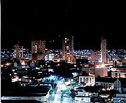
Anápolis
Encyclopedia
| cing="0"> | |
 |
 |
Goiás
Goiás is a state of Brazil, located in the central part of the country. The name Goiás comes from the name of an indigenous community...
Goiânia
-Climate:The city has a tropical wet and dry climate with an average temperature of . There's a wet season, from October to April, and a dry one, from May to September. Annual rainfall is around 1,520 mm....
:
Anápolis is the third largest city
City
A city is a relatively large and permanent settlement. Although there is no agreement on how a city is distinguished from a town within general English language meanings, many cities have a particular administrative, legal, or historical status based on local law.For example, in the U.S...
in the State of Goiás
Goiás
Goiás is a state of Brazil, located in the central part of the country. The name Goiás comes from the name of an indigenous community...
in Brazil
Brazil
Brazil , officially the Federative Republic of Brazil , is the largest country in South America. It is the world's fifth largest country, both by geographical area and by population with over 192 million people...
. It lies in the center of a rich agricultural region and has become a leader in food processing and pharmaceutical plants.
Location and population
The area of the municipality is 918.3 km2. and the limiting municipalities are AbadiâniaAbadiânia
Abadiânia is a small town and municipality in the state of Goiás, Brazil. It is home to a famous Brazilian medium and "psychic surgeon" — João de Deus.-Location:Abadiânia is part of the Entorno de Brasília statistical micro-region...
, Campo Limpo de Goiás
Campo Limpo de Goiás
Campo Limpo de Goiás is a small town and municipality in central Goiás state, Brazil. It separated from the municipality of Anápolis in 1997....
, Gameleira de Goiás
Gameleira de Goiás
Gameleira de Goiás is a municipality in central Goiás state, Brazil. The population in 2007 was 3,289 in a total area of 595 square kilometers.-Geographical Information:...
, Goianápolis
Goianápolis
Goianápolis is a small town and municipality in central Goiás state, Brazil. It had a population of 11,159 in a total area of 162.38 km²...
, Leopoldo de Bulhões
Leopoldo de Bulhões
Leopoldo de Bulhões is a small town and municipality in central Goiás state, Brazil. The total area was 495.0 km² in October 2002) and the population was 8,916 in 2007...
, Nerópolis
Nerópolis
Nerópolis is a small city and municipality in central Goiás state, Brazil.-Location:The municipality is part of the metropolitan region of Goiânia, which is 42 kilometers to the west. It is nationally known as the city of garlic and sweets...
, Pirenópolis
Pirenópolis
Pirenópolis is a town located in the Brazilian state of Goiás. It is well known for its waterfalls and colonial architecture, and a popular festival involving mounted horses called Festa do Divino Espírito Santo which takes place 45 days after Easter....
, Silvânia
Silvânia
Silvânia is a small city and municipality in southcentral Goiás state, Brazil.-Location and highway connections:Silvânia is located 77 kilometers from the state capital of Goiânia, 180 km...
and Terezópolis de Goiás
Terezópolis de Goiás
Terezópolis de Goiás is a small town and municipality in central Goiás state, Brazil.-Location:Terezópolis is located in the Goiânia Microregion, 28 kilometers northeast of the capital, Goiânia...
.
Anápolis is also the center of the Anápolis Microregion
Anápolis Microregion
The Anápolis Microregion is a region of central Goiás state, Brazil, including municipalities surrounding the city of Anápolis. For a map see *Population: 517,221 inhabitants *Cities: 19*Total Area: 8,386.80 km²...
, englobing 19 cities with a total population of 511,952 and an area of 8,386.80 km2.
The resident population in 2003 was 298,155, of which 294,443 lived in the urban area and 3,712 in the rural area. Estimated population for 2008 was 331,329. The city has experienced rapid growth since 1980 when the population was 180,000.
The city is built on a plateau at an elevation of 1,017 meters, one of the highest in Brazil. Because of this, the climate is mild without extremes and is generally cooler than nearby Goiânia.
Communications
Anápolis is located on the main Brasília-Goiânia highway (BR 060), which has now become a four-lane motorway. It is also the starting point for the famous Belém-Brasília highway (BR 153). Distances to Goiânia - 54 km, Brasília - 140 km, and São Paulo - 872 km.The municipality is served by a branch of the Centro-Atlântica railroad, with 685 km. of network in Goiás, which allows for connections with the important ports of the country. Anápolis will be zero kilometer for the future North-South railroad, which will connect with the Port of Itaqui, in Maranhão, as well as with other strategic points in the North and Northeast.
Anápolis has a municipal airport
Airport
An airport is a location where aircraft such as fixed-wing aircraft, helicopters, and blimps take off and land. Aircraft may be stored or maintained at an airport...
, which will soon be upgraded to a national cargo
Cargo
Cargo is goods or produce transported, generally for commercial gain, by ship, aircraft, train, van or truck. In modern times, containers are used in most intermodal long-haul cargo transport.-Marine:...
facility.
Economy
After GoiâniaGoiânia
-Climate:The city has a tropical wet and dry climate with an average temperature of . There's a wet season, from October to April, and a dry one, from May to September. Annual rainfall is around 1,520 mm....
, Anápolis is the most developed municipality in the state. It also has the fastest developing industrial sector with several high-tech companies locating in the Central Region in Brazil. Communications are excellent, with good highways connecting the city with both Goiânia
Goiânia
-Climate:The city has a tropical wet and dry climate with an average temperature of . There's a wet season, from October to April, and a dry one, from May to September. Annual rainfall is around 1,520 mm....
and Brasília
Brasília
Brasília is the capital city of Brazil. The name is commonly spelled Brasilia in English. The city and its District are located in the Central-West region of the country, along a plateau known as Planalto Central. It has a population of about 2,557,000 as of the 2008 IBGE estimate, making it the...
. The recently built railroad terminus also connects with major population centers of the south.
There is a large pool of educated professionals produced by the several institutions of higher learning in the city, e.g. the State University of Goiás. The surrounding land is excellent for intensive production of fruit like oranges, bananas, and sugarcane.
All of these factors make Anápolis the most competitive city after the capital.
- Gross Domestic Product: 6.265 billion Reais in 2008 as pointed out by IBGE, which was the second largest in the state after GoiâniaGoiânia-Climate:The city has a tropical wet and dry climate with an average temperature of . There's a wet season, from October to April, and a dry one, from May to September. Annual rainfall is around 1,520 mm....
and the seventh largest in BrazilBrazilBrazil , officially the Federative Republic of Brazil , is the largest country in South America. It is the world's fifth largest country, both by geographical area and by population with over 192 million people...
. This PIB was 5.7% of the state PIB of 75.274 billion Reais in 2008 as referenced by IBGE IBGE - Cidades@. See Portalsepin for the complete list of all municipalities in GoiásGoiásGoiás is a state of Brazil, located in the central part of the country. The name Goiás comes from the name of an indigenous community...
.
Ranking of Anápolis on list of top ten municipalities in GDP in Goiás in 2008 (in Reais) IBGE - Cidades@:
- GoiâniaGoiânia-Climate:The city has a tropical wet and dry climate with an average temperature of . There's a wet season, from October to April, and a dry one, from May to September. Annual rainfall is around 1,520 mm....
- 19.457 billion - Anápolis - 6.265 billion
- Aparecida de GoiâniaAparecida de GoiâniaAparecida de Goiânia is a city and municipality in central Goiás, Brazil. It is the second largest city in the state and a bustling industrial center.-Location:...
- 3.873 billion - Rio VerdeRio Verde, GoiásRio Verde is a city and municipality in the Brazilian state of Goiás. It is a fast-growing center and is the largest producer of grains in the state.-Location:...
- 3.615 billion - CatalãoCatalãoCatalão is a small city and municipality located in the south of the state of Goiás, in Brazil. It is a large producer of grains, cattle, and phosphates and has a John Deere and Mitsubishi factory.-Demographics:*Population density: 17.85 inhab/km²...
- 3.348 billion - Senador CanedoSenador CanedoSenador Canedo is a city and municipality in central Goiás state, Brazil. It is the center of the petrochemical industry for the state.-Location:Senador Canedo is crossed by two state highways, GOs 020 and 010...
- 2.304 billion - ItumbiaraItumbiaraItumbiara is a small city and municipality in the extreme south of the state of Goiás, Brazil. The population was 100,000 in a total area of 2,461,3 km²...
- 2.047 billion - JataíJataíJataí is a municipality in southern Goiás state, Brazil. Its population was 88,048 in a total area of 7,174.2 km². Jataí is a major producer of agricultural products, including soybeans, rice, and corn. It has the largest herd of cattle in the state and is a large producer of poultry and...
- 1.860 billion - LuziâniaLuziâniaLuziânia is a city and municipality in the state of Goiás, Brazil. This fast-growing city is a great producer of agricultural products including soybeans and beans.-Location:Luziânia is located 68 km...
- 1.805 billion - São Simão - 1.343 billion
- Gross Domestic Product per capita: 18,910 Reais in 2008, which was just above the state average of 12,878 Reais in the same year. http://www.ibge.gov.br/home/estatistica/economia/pibmunicipios/2004_2008/tabelas_pdf/tab01.pdf
Historically Anápolis has always been the center of a rich agricultural area. Animal raising has always been the main economic mainstay of the region. In 2003 the municipality had 65,000 head of beef cattle, 8,000 pigs, 138,000 poultry (second place in the state), and 9,500 head of dairy cattle. In addition rice (1 km2 / 160 tons), corn (16 km2 / 7,200 tons), and soybeans (17 km2 / 4,590 tons) are also grown in quantity.
Other important crops:
- tomatoes: 0,5 km2 / 2,250 tons
- wheat: 0.8 km2 / 360 tons
- sugarcane: 0.2 km2 / 800 tons
- manioc: 2 km2 / 3,000 tons
- bananas: 8.3 km2 / 8,300 tons
- coffee: 0.5 km2 / 30 tons
- coconut: 0.27 km2 / 216 thousand fruits
- citrus fruits: 2.75 km2 / 3,800 tons
- passion fruit: 0.05 km2 / 40 tons
Source: IBGE
DAIA (Distrito Agro-Industrial de Anapolis) is the industrial sector of Anapolis. It includes many large companies such as Laboratório Teuto Brasil, a pharmaceuticals manufacturing plant, the largest generic medicine-producing plant in Brazil. The federal government decided to build a major logistical centre around the DAIA, which is a distribution point for goods throughout Brazil by road, rail and air.
The main entrepreneurial sectors employing workers in 2003 were the transformation industry with 12,980 workers, construction with 1,222 workers, commerce with 18,114 workers, hotels and restaurants with 1,635 workers, transportation with 3,880 workers, services with 2,429 workers, public administration, defense, and social security with 6,724 workers, education with 3,723 workers, and health with 2,247 workers.
There were 23 financial institutions in 2004.
Motor vehicles
In May, 2011 http://www.denatran.gov.br/frota.htm:- automobiles: 90,332
- trucks: 9,151
- pickups: 13,542
- motorcycles: 39,044
Education and health
In education the city is well served. In addition to the more than 100 primary schools there are eight secondary schools and several public and private colleges. The colleges are: Associação Educativa Evangélica, Faculdade de Filosofia São Miguel Arcanjo, Faculdade do Instituto Brasil-FIBRA, Faculdade Anhanguera de Anápolis, and Faculdade Raízes. It is home to a campus of the State University of Goiás (UEG) and the UniEVANGÉLICA, a Protestant university and one of the first institutes of higher education founded in the state of Goiás.There are 94 health establishments including 25 hospitals with 1,445 beds. The infant mortality rate is 22.15.
- Doctors: 811 (IBGE 2002)
- Nurses: 66
- Dentists: 105
- Infant mortality rate: 20.77 in 2000. It was 28.27 in 1991.
- Primary schools: 56,665 students, 2,517 teachers, 51 schools (IBGE 2004)
- Secondary schools: 2,319 students, 933 teachers, 40 schools
College: 9,103 students, 1,527 teachers, 6 schools
- Literacy rate: 92.0% in 2000. It was 87.5% in 1991. http://www.seplan.go.gov.br/sepin/perfilweb/mostraNew.asp
The water supply system reaches 95% of the population while the sewage system reaches 53%.
The city is also the seat of the Roman Catholic Diocese of Anápolis
Roman Catholic Diocese of Anápolis
The Roman Catholic Diocese of Anápolis is a diocese located in the city of Anápolis in the Ecclesiastical province of Goiânia in Brazil.-History:* October 11, 1966: Established as Diocese of Anápolis from the Metropolitan Archdiocese of Goiânia-Leadership:...
.
Air force base
The Força Aérea Brasileira (Brazilian Air Force) operates one of their most important bases here, protecting the nearby capital as well as being an important element of the SIVAM project, the Amazonas survey system.Ranking on the UN MHDI
(See the Human Development IndexHuman Development Index
The Human Development Index is a composite statistic used to rank countries by level of "human development" and separate "very high human development", "high human development", "medium human development", and "low human development" countries...
)
- Life expectancy: 70.2
- Adult literacy rate: 0.912
- School attendance rate: 0.844
- MHDI: 0.788
- State ranking: 16 (out of 242 municipalities)
- National ranking: 851 (out of 5,507 municipalities)
All data are from 2000
For the complete list see http://www.frigoletto.com.br/GeoEcon/idhgo.htm