

Car-free zone
Encyclopedia
Street
A street is a paved public thoroughfare in a built environment. It is a public parcel of land adjoining buildings in an urban context, on which people may freely assemble, interact, and move about. A street can be as simple as a level patch of dirt, but is more often paved with a hard, durable...
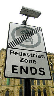
or an area to pedestrian only use is called pedestrianisation.
Pedestrian zones have a great variety of attitudes or rules towards human powered vehicles such as bicycles, inline skates
Inline skates
In-line skates are a type of roller skate used for inline skating. Unlike quad skates, which have two front and two rear wheels, inline skates have two, three, four, or five wheels arranged in a single line...
, skateboard
Skateboard
A skateboard is typically a specially designed plywood board combined with a polyurethane coating used for making smoother slides and stronger durability, used primarily for the activity of skateboarding. The first skateboards to reach public notice came out of the surfing craze of the early 1960s,...
s and kick scooter
Kick scooter
A kick scooter or push scooter, originally scooter, is a human-powered vehicle with a handlebar, deck and wheels that is propelled by a rider pushing off the ground. The most common scooters today have two hard small wheels, are made primarily of aluminium and fold for convenience...
s. Some have a total ban on anything with wheels, others ban certain categories, others segregate the human-powered wheels from foot traffic, and others still have no rules at all. Many of the Middle Eastern examples have no wheeled traffic, but use donkeys for freight transport.
Towns in many low-income countries are effectively largely pedestrian only simply because cars are uncommon in those countries.
Europe
The term "pedestrianised zone" is used in British EnglishBritish English
British English, or English , is the broad term used to distinguish the forms of the English language used in the United Kingdom from forms used elsewhere...
, and most other European countries use a similar term (French: , German: , Spanish: ).
The first purpose-built pedestrian street in Europe was the Lijnbaan
Lijnbaan
The Lijnbaan is the main shopping street of Rotterdam. It was opened in 1953, as the main pedestrian street in the new shopping district, after the old shopping district was completely destroyed during the bombing of Rotterdam by the German Luftwaffe. It was designed by the firm Van den Broek &...
in Rotterdam opened 1953. The first pedestrianized shopping centre in the United Kingdom was in Stevenage
Stevenage
Stevenage is a town and borough in Hertfordshire, England. It is situated to the east of junctions 7 and 8 of the A1, and is between Letchworth Garden City to the north, and Welwyn Garden City to the south....
in 1959.
A large number of European towns and cities have made part of their centres car-free since the early 1960s. These are often accompanied by car parks on the edge of the pedestrianised zone, and, in the larger cases, park and ride
Park and ride
Park and ride facilities are car parks with connections to public transport that allow commuters and other people wishing to travel into city centres to leave their vehicles and transfer to a bus, rail system , or carpool for the rest of their trip...
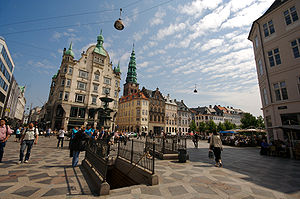
schemes. Central Copenhagen
Copenhagen
Copenhagen is the capital and largest city of Denmark, with an urban population of 1,199,224 and a metropolitan population of 1,930,260 . With the completion of the transnational Øresund Bridge in 2000, Copenhagen has become the centre of the increasingly integrating Øresund Region...
is one of the largest and oldest: It was converted from car trafic into pedestrian zone in 1962 on November 17 as an experiment and is centered on Strøget
Strøget
Strøget is a carfree zone in Copenhagen, Denmark. This popular tourist attraction in the centre of town is the longest pedestrian shopping area in Europe....
, a pedestrian shopping street, which is in fact not a single street but a series of interconnected avenues which create a very large pedestrian zone, although it is crossed in places by streets with vehicular traffic. Most of these zones allow delivery trucks to service the businesses located there during the early morning, and street-cleaning vehicles will usually go through these streets after most shops have closed for the night.
Car free towns, cities and regions
There are many towns and cities in Europe which have never allowed motor vehicleMotor vehicle
A motor vehicle or road vehicle is a self-propelled wheeled vehicle that does not operate on rails, such as trains or trolleys. The vehicle propulsion is provided by an engine or motor, usually by an internal combustion engine, or an electric motor, or some combination of the two, such as hybrid...
s. The archetypal
Archetype
An archetype is a universally understood symbol or term or pattern of behavior, a prototype upon which others are copied, patterned, or emulated...
example is Venice, which occupies myriad islands in a lagoon, divided by and accessed from canal
Canal
Canals are man-made channels for water. There are two types of canal:#Waterways: navigable transportation canals used for carrying ships and boats shipping goods and conveying people, further subdivided into two kinds:...
s. Motor traffic stops at the car park at the head of the viaduct from the mainland, and water transport or walking takes over from there. However, motor vehicles are allowed on the Lido. Other examples are Cinque Terre
Cinque Terre
The Cinque Terre is a rugged portion of coast on the Italian Riviera. It is in the Liguria region of Italy, to the west of the city of La Spezia. "The Five Lands" is composed of five villages: Monterosso al Mare, Vernazza, Corniglia, Manarola, and Riomaggiore...
in Italy
Italy
Italy , officially the Italian Republic languages]] under the European Charter for Regional or Minority Languages. In each of these, Italy's official name is as follows:;;;;;;;;), is a unitary parliamentary republic in South-Central Europe. To the north it borders France, Switzerland, Austria and...
, Ghent
Ghent
Ghent is a city and a municipality located in the Flemish region of Belgium. It is the capital and biggest city of the East Flanders province. The city started as a settlement at the confluence of the Rivers Scheldt and Lys and in the Middle Ages became one of the largest and richest cities of...
in Belgium, which is one of the largest car-free areas in Europe and the Old Town of Rhodes
Rhodes, Greece
Rhodes is the principal city and a former municipality on the island of Rhodes, in the Dodecanese, Greece. Since the 2011 local government reform it is part of the municipality Rhodes, of which it is the seat and a municipal unit. It has a population of approximately 80,000. Rhodes has been famous...
, since many, if not most of the streets are too steep and/or narrow for automobile circulation. Mount Athos
Mount Athos
Mount Athos is a mountain and peninsula in Macedonia, Greece. A World Heritage Site, it is home to 20 Eastern Orthodox monasteries and forms a self-governed monastic state within the sovereignty of the Hellenic Republic. Spiritually, Mount Athos comes under the direct jurisdiction of the...
, an Autonomous Monastic State within the sovereignty
Sovereignty
Sovereignty is the quality of having supreme, independent authority over a geographic area, such as a territory. It can be found in a power to rule and make law that rests on a political fact for which no purely legal explanation can be provided...
of Greece
Greece
Greece , officially the Hellenic Republic , and historically Hellas or the Republic of Greece in English, is a country in southeastern Europe....
, does not permit automobiles on its territory. Trucks and work-related vehicles only are in use there. The medieval city of Mdina
Mdina
Mdina, Città Vecchia, or Città Notabile, is the old capital of Malta. Mdina is a medieval walled town situated on a hill in the centre of the island. Punic remains uncovered beyond the city’s walls suggest the importance of the general region to Malta’s Phoenician settlers. Mdina is commonly...
in Malta
Malta
Malta , officially known as the Republic of Malta , is a Southern European country consisting of an archipelago situated in the centre of the Mediterranean, south of Sicily, east of Tunisia and north of Libya, with Gibraltar to the west and Alexandria to the east.Malta covers just over in...
does not allow automobiles past the city walls. It is known as the "Silent City" because of the absence of motor traffic in the city. Sark
Sark
Sark is a small island in the Channel Islands in southwestern English Channel, off the French coast of Normandy. It is a royal fief, geographically located in the Channel Islands in the Bailiwick of Guernsey, with its own set of laws based on Norman law and its own parliament. It has a population...
, an island in the English Channel
English Channel
The English Channel , often referred to simply as the Channel, is an arm of the Atlantic Ocean that separates southern England from northern France, and joins the North Sea to the Atlantic. It is about long and varies in width from at its widest to in the Strait of Dover...
is a car-free zone where only bicycles, carriages and tractors are used as transportation.
Definitions and types
The above section describes places which are mainly carfree for historical reasons. The term carfree development implies a physical change - either new building or changes to an existing built area.Melia et al (2010) define carfree development as follows:
Carfree developments are residential or mixed use developments which:
- Normally provide a traffic free immediate environment, and:
- Offer no parking or limited parking separated from the residence, and:
- Are designed to enable residents to live without owning a car.
This definition (which they distinguish from the more common 'low car development') is based mainly on experience in Northwestern Europe, where the movement for carfree development began. Within this definition, three types are identified:
- Vauban model
- Limited Access model
- Pedestrianised centres with residential population
Vauban
VaubanVauban, Freiburg
Vauban is a new neighborhood of 5,000 inhabitants and 600 jobs 4 km to the south of the town center in Freiburg, Germany. It was built as "a sustainable model district" on the site of a former French military base, and is named after Sébastien Le Prestre de Vauban, the 17th century French...
is according to this definition, the largest carfree development in Europe, with over 5,000 residents. Whether it can be considered carfree is open to debate: many local people prefer the term 'stellplatzfrei' - literally 'free from parking spaces' to describe the traffic management system there. Vehicles are allowed down the residential streets at walking pace to pick up and deliver but not to park, although there are frequent infractions. Residents of the stellplatzfrei 'areas must sign an annual declaration stating whether they own a car or not. Car owners must purchase a place in one of the multi-storey car park
Multi-storey car park
A multi-storey car-park is a building designed specifically to be for car parking and where there are a number of floors or levels on which parking takes place...
s on the periphery, run by a council-owned company. The cost of these spaces – € 17,500 in 2006, plus a monthly fee – acts as a disincentive to car ownership.
Limited Access type
The more common form of carfree development involves some sort of physical barrier, which prevents motor vehicles from penetrating into a carfree interior. Melia et al describe this as the 'Limited Access' type. In some cases, such as Stellwerk 60 in Cologne, there is a removable barrier, controlled by a residents' organisations. In others such as Waterwijk (Amsterdam)Waterwijk (Amsterdam)
Waterwijk is a neighborhood of Amsterdam, Netherlands....
(article in Dutch) vehicular access is only available from the exterior.
Pedestrianised centres
Whereas the first two models apply to newly-built carfree developments, most pedestrianised city, town and district centres have been retro-fitted. Pedestrianised centres may be considered carfree developments where they include a significant number of residents, mostly without cars, due to new residential development within them, or because they already included dwellings when they were pedestrianised. The largest example in Europe is Groningen with a city centre population of 16,500.Benefits and problems of carfree developments
Several studies have been done on European carfree developments. The most comprehensive was conducted in 2000 by Jan Scheurer. Other more recent studies have been made of specific carfree areas such as Vienna's Florisdorf carfree development.Characteristics of carfree developments:
- very low levels of car use, resulting in much less traffic on surrounding roads.
- high rates of walking and cycling.
- more independent movement and active play amongst children.
- less land taken for parking and roads - more available for green or social space.
The main benefits found for carfree developments:
- Low athmospheric emissions.
- Low road accident rates.
- Better built environment conditions.
- Discouragement of private car and other motorized vehicles (measure of travel demand management).
- Encouragement of activo modes.
The main problems related to parking management. Where parking is not controlled in the surrounding area, this often results in complaints from neighbours about overspill parking
Overspill parking
Overspill parking is the parking of vehicles beyond the main area provided for the purpose. It can occur because provided parking spaces are insufficient for demand or considered unsatisfactory for some reason...
.
North America
Transit mall
A transit mall is a street, or set of streets, in a city or town along which automobile traffic is prohibited or greatly restricted and only public transit vehicles, bicycles and pedestrians are permitted....
. Many pedestrian streets are surfaced with cobblestone
Cobblestone
Cobblestones are stones that were frequently used in the pavement of early streets. "Cobblestone" is derived from the very old English word "cob", which had a wide range of meanings, one of which was "rounded lump" with overtones of large size...
s, or pavement
Sidewalk
A sidewalk, or pavement, footpath, footway, and sometimes platform, is a path along the side of a road. A sidewalk may accommodate moderate changes in grade and is normally separated from the vehicular section by a curb...
brick
Brick
A brick is a block of ceramic material used in masonry construction, usually laid using various kinds of mortar. It has been regarded as one of the longest lasting and strongest building materials used throughout history.-History:...
s, thus discouraging any kind of wheeled traffic, including wheelchairs. They are rarely completely free of motor vehicles. Often, all of the cross streets are open to motorized traffic, which thus intrudes on the pedestrian flow at every street corner. In a few pedestrian streets with no cross street cars or trucks, deliveries are made by trucks by night.
Canada
Some Canadian examples are the Sparks StreetSparks Street
Sparks Street is a street in downtown Ottawa, Canada that was converted into an outdoor pedestrian street in 1966, making it the earliest such street or mall in North America....
Mall area of Ottawa
Ottawa
Ottawa is the capital of Canada, the second largest city in the Province of Ontario, and the fourth largest city in the country. The city is located on the south bank of the Ottawa River in the eastern portion of Southern Ontario...
, the Distillery District in Toronto
Toronto
Toronto is the provincial capital of Ontario and the largest city in Canada. It is located in Southern Ontario on the northwestern shore of Lake Ontario. A relatively modern city, Toronto's history dates back to the late-18th century, when its land was first purchased by the British monarchy from...
, Scarth Street Mall in Regina
Regina, Saskatchewan
Regina is the capital city of the Canadian province of Saskatchewan. The city is the second-largest in the province and a cultural and commercial centre for southern Saskatchewan. It is governed by Regina City Council. Regina is the cathedral city of the Roman Catholic and Romanian Orthodox...
, Stephen Avenue Mall in Calgary
Calgary
Calgary is a city in the Province of Alberta, Canada. It is located in the south of the province, in an area of foothills and prairie, approximately east of the front ranges of the Canadian Rockies...
(with certain areas open to parking for permit holders) and part of Prince Arthur street and the Gay Village
Gay Village, Montreal
Montreal's Gay Village is located on Saint Catherine Street East, centred on Beaudry metro station, and on Amherst Street in the Ville-Marie borough of the city...
in Montreal
Montreal
Montreal is a city in Canada. It is the largest city in the province of Quebec, the second-largest city in Canada and the seventh largest in North America...
. Algonquin and Ward's Islands, parts of the Toronto Islands
Toronto Islands
The Toronto Islands are a chain of small islands in the city of Toronto, Ontario. Comprising the only group of islands in the western part of Lake Ontario, the Toronto Islands are located just offshore from the city centre, and provide shelter for Toronto Harbour...
group, are also car-free zones for all 700 residents. Since the summer of 2004, Toronto has also been experimenting with "Pedestrian Sundays"http://www.pskensington.ca/ in its busy Kensington Market
Kensington Market
Kensington Market is a distinctive multicultural neighbourhood in Downtown Toronto, Ontario, Canada. The Market is an older neighbourhood and one of the city's most well-known. In November 2006, it was designated a National Historic Site of Canada. Robert Fulford wrote in 1999 that "Kensington...
. Granville Mall
Granville Mall (Halifax)
Granville Mall is an area in downtown Halifax, Nova Scotia, Canada. It was formerly part of Granville Street, until nearby developments, such as the Cogswell Interchange, and Scotia Square, rendered this section fairly useless traffic-wise and it was converted into a pedestrian mall...
in Halifax, Nova Scotia was a run-down section of buildings on Granville Street built in the 1840s that was restored in the late 1970s. The area was then closed off to vehicles.
United States
United States
The United States of America is a federal constitutional republic comprising fifty states and a federal district...
, these zones as commonly called pedestrian malls or pedestrian streets. Pedestrian zones are rare in the United States, although some cities have created single pedestrian streets.
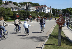
Mackinac Island
Mackinac Island
Mackinac Island is an island and resort area covering in land area, part of the U.S. state of Michigan. It is located in Lake Huron, at the eastern end of the Straits of Mackinac, between the state's Upper and Lower Peninsulas. The island was home to a Native American settlement before European...
, between the upper and lower peninsulas of Michigan, banned horseless carriages in 1896, making it auto free. The original ban still stands, except for emergency vehicles. Travel on the island is largely by foot, bicycle, or horse-drawn carriage. An 8.5 miles (13.7 km) road, M-185
M-185 (Michigan highway)
M-185 is a state trunkline highway in the U.S. state of Michigan that circles Mackinac Island, a popular tourist destination on the Lake Huron side of the Straits of Mackinac, along the island's shoreline. A narrow paved road of , it offers scenic views of the straits that divide the Upper and the...
rings the island, and numerous roads cover the interior. M-185 is one of the few highways in the United States without motorized vehicles.
Downtown Crossing
Downtown Crossing
Downtown Crossing is a shopping district in Boston, Massachusetts, located due east of Boston Common and west of the Financial District. It features large department stores as well as restaurants, music stores, souvenir sellers, general retail establishments, and many street vendors...
in Boston
Boston
Boston is the capital of and largest city in Massachusetts, and is one of the oldest cities in the United States. The largest city in New England, Boston is regarded as the unofficial "Capital of New England" for its economic and cultural impact on the entire New England region. The city proper had...
is a shopping district which prohibits automobiles during daytime hours. Both the main thoroughfare of Golden Gate Park
Golden Gate Park
Golden Gate Park, located in San Francisco, California, is a large urban park consisting of of public grounds. Configured as a rectangle, it is similar in shape but 20% larger than Central Park in New York, to which it is often compared. It is over three miles long east to west, and about half a...
in San Francisco, and Memorial Drive, a busy road in Cambridge, MA are closed to car traffic each Sunday during the summer to allow pedestrians, bikers, skateboarders and roller/inlineskaters an opportunity to use the road. In 2009, the Broadway intersection of Times Square
Times Square
Times Square is a major commercial intersection in the borough of Manhattan in New York City, at the junction of Broadway and Seventh Avenue and stretching from West 42nd to West 47th Streets...
in New York City
New York City
New York is the most populous city in the United States and the center of the New York Metropolitan Area, one of the most populous metropolitan areas in the world. New York exerts a significant impact upon global commerce, finance, media, art, fashion, research, technology, education, and...
became pedestrian only.
Fire Island in Suffolk County, New York
Suffolk County, New York
Suffolk County is a county located in the U.S. state of New York on the eastern portion of Long Island. As of the 2010 census, the population was 1,493,350. It was named for the county of Suffolk in England, from which its earliest settlers came...
is pedestrianised east of the Fire Island Lighthouse
Fire Island Lighthouse
The Fire Island Light is a visible landmark on the Great South Bay, in southern Suffolk County, New York on the western end of Fire Island, a barrier island off the southern coast of Long Island...
and west of Smith Point County Park
Smith Point County Park
Smith Point County Park is a park located fronting on the Atlantic Ocean on the east end of Fire Island, New York, United States, in central Long Island by Shirley. It is the largest park owned by Suffolk County, New York....
(with the exception of emergency vehicles).
Supai, Arizona
Supai, Arizona
Supai is a census-designated place in Coconino County, Arizona, United States, within the Grand Canyon.As of the 1990 census, the CDP had a population of 423; the 2000 census erroneously recorded a population of 0...
, located within the Havasupai Indian Reservation is entirely car-free, the only community in the United States where mail is still carried out by mule. Supai is 8 miles to the nearest road, accessible only by foot, horse/mule, or helicopter.
Argentina
Córdoba, Argentina
Córdoba is a city located near the geographical center of Argentina, in the foothills of the Sierras Chicas on the Suquía River, about northwest of Buenos Aires. It is the capital of Córdoba Province. Córdoba is the second-largest city in Argentina after the federal capital Buenos Aires, with...
, Mendoza
Mendoza, Argentina
Mendoza is the capital city of Mendoza Province, in Argentina. It is located in the northern-central part of the province, in a region of foothills and high plains, on the eastern side of the Andes. As of the , Mendoza's population was 110,993...
and Rosario have lively pedestrianised street centers combined with town square
Town square
A town square is an open public space commonly found in the heart of a traditional town used for community gatherings. Other names for town square are civic center, city square, urban square, market square, public square, and town green.Most town squares are hardscapes suitable for open markets,...
s and parks which are crowded with people walking at every hour of the day and night. Most (if not all) of Argentina's cities are human-scale and pedestrian-friendly, although vehicle traffic may be hectic in some areas.
In Buenos Aires
Buenos Aires
Buenos Aires is the capital and largest city of Argentina, and the second-largest metropolitan area in South America, after São Paulo. It is located on the western shore of the estuary of the Río de la Plata, on the southeastern coast of the South American continent...
, some stretches of Calle Florida
Florida Street
Florida Street is an elegant shopping street in Downtown Buenos Aires, Argentina. A pedestrian street since 1971, some stretches have been pedestrianized since 1913....
have been pedestrianised since 1913. which makes it one of the oldest car-free thoroughfares in the world today. Car-free Calle Florida, Lavalle and other streets contribute to a vibrant shopping and restaurant scene where street performer
Busking
Street performance or busking is the practice of performing in public places, for gratuities, which are generally in the form of money and edibles...
s and tango
Tango (dance)
Tango dance originated in the area of the Rio de la Plata , and spread to the rest of the world soon after....
dancers abound, streets are crossed with vehicular traffic at corners.
Brazil
Paquetá IslandPaquetá Island
Paquetá Island is an island in Guanabara Bay, Rio de Janeiro. The name of the island is a Tupi word meaning "many pacas". The island is an auto-free zone, so travel is limited to bicycles and horse-drawn carriages. Paquetá has twenty baobabs, a type of African tree - the only ones in Brazil beside...
in Rio de Janeiro
Rio de Janeiro
Rio de Janeiro , commonly referred to simply as Rio, is the capital city of the State of Rio de Janeiro, the second largest city of Brazil, and the third largest metropolitan area and agglomeration in South America, boasting approximately 6.3 million people within the city proper, making it the 6th...
is auto-free. The only cars allowed on the island are police and ambulance vehicles.
In Rio de Janeiro, the roads beside the beaches are auto-free on Sundays and holidays.
Chile
Chile has many large pedestrian streets. An example is Paseo Ahumada in Santiago and Calle Valparaiso in Viña del Mar.Colombia
Since 1998, under the governance of former major of BogotáBogotá
Bogotá, Distrito Capital , from 1991 to 2000 called Santa Fé de Bogotá, is the capital, and largest city, of Colombia. It is also designated by the national constitution as the capital of the department of Cundinamarca, even though the city of Bogotá now comprises an independent Capital district...
, Enrique Peñalosa
Enrique Peñalosa
Enrique Peñalosa Londoño is a Colombian politician and New Urbanist. He was mayor of Bogotá, from 1998 until 2001, and was runner-up in 2007. He is running in 2011 for mayor as the Green Party candidate. He has also worked as a journalist and consultant on urban and transportation policy...
, created several pedestrian streets, plaza
Plaza
Plaza is a Spanish word related to "field" which describes an open urban public space, such as a city square. All through Spanish America, the plaza mayor of each center of administration held three closely related institutions: the cathedral, the cabildo or administrative center, which might be...
s and cyclepaths (see Ciclovía
Ciclovía
Ciclovía is term which translates from Spanish into English as "bike path" and now used worldwide to describe either a permanently designated bicycle route or a temporary event, the closing of the street to automobiles for use by others.-Origins in Colombia:Each Sunday and holiday certain main...
).
On of the most important interventions was the construction of the Jimenez Avenue (Bogota). Before 2000, this road was composed by two carriageways of three lanes per direction full of traditional buses. Congestion was permanent. The renewal measure include the inclusion of one Transmilenio
TransMilenio
TransMilenio is a bus rapid transit system that serves Bogotá, the capital of Colombia. The system opened to the public in December 2000, covering Av. Caracas and Calle 80...
corridor and the partial excusion of roadways. This Avenue is 2.3 km long Jimenez Avenue (Bogota). Other important projects were the 17 km long Porvenir Promenade.
These measures are considered fundamental within the Master Plan, which is clearly focused towars Sustainable Transportation.
Asia
In Hong KongHong Kong
Hong Kong is one of two Special Administrative Regions of the People's Republic of China , the other being Macau. A city-state situated on China's south coast and enclosed by the Pearl River Delta and South China Sea, it is renowned for its expansive skyline and deep natural harbour...
, the most popular pedestrian street is Sai Yeung Choi Street
Sai Yeung Choi Street
Sai Yeung Choi Street are two streets in Mong Kok, Kowloon, Hong Kong, namely, Sai Yeung Choi Street South and Sai Yeung Choi Street North . Although officially two streets, local people seldom make distinction between them...
. It was converted into a pedestrian street in 2003. From December 2008 to May 2009, there were three acid attacks
Mong Kok acid attacks
The Mong Kok acid attacks were incidents in 2008, 2009, and 2010 where plastic bottles filled with corrosive liquid were thrown onto shoppers on Sai Yeung Choi Street South, Hong Kong, a pedestrian street and popular shopping area...
during which corrosive liquids were placed in plastic bottles and thrown from the roof of apartments down onto the street.

Japan
Japan is an island nation in East Asia. Located in the Pacific Ocean, it lies to the east of the Sea of Japan, China, North Korea, South Korea and Russia, stretching from the Sea of Okhotsk in the north to the East China Sea and Taiwan in the south...
are called hokōsha tengoku (歩行者天国, literally "pedestrian heaven"). Clis Road, in Sendai, Japan, is a covered pedestrian mall. Several major streets in Tokyo
Tokyo
, ; officially , is one of the 47 prefectures of Japan. Tokyo is the capital of Japan, the center of the Greater Tokyo Area, and the largest metropolitan area of Japan. It is the seat of the Japanese government and the Imperial Palace, and the home of the Japanese Imperial Family...
are closed to vehicles during weekends. One particular temporary hokōsha tengoku in Akihabara
Akihabara
, also known as , is an area of Tokyo, Japan. It is located less than five minutes by rail from Tokyo Station. Its name is frequently shortened to in Japan...
was cancelled after the Akihabara massacre
Akihabara massacre
The was an incident of mass murder that took place on Sunday, June 8, 2008, in the Akihabara shopping quarter for electronics, video games and comics in Sotokanda, Chiyoda, Tokyo, Japan.At 12:33 p.m...
in which a man rammed a truck into the pedestrian traffic and subsequently stabbed more than 12 people.
Nanjing Road in Shanghai is perhaps the most well-known pedestrian zone in mainland China
Mainland China
Mainland China, the Chinese mainland or simply the mainland, is a geopolitical term that refers to the area under the jurisdiction of the People's Republic of China . According to the Taipei-based Mainland Affairs Council, the term excludes the PRC Special Administrative Regions of Hong Kong and...
. Chunxilu is the most well-known in western China.
Insadong
Insadong
Insadong is a dong, or neighborhood of the Jongno-gu district of the South Korean city of Seoul. The main street is Insadong-gil, which is connected to a multitude of alleys that lead deeper into the district...
in Seoul
Seoul
Seoul , officially the Seoul Special City, is the capital and largest metropolis of South Korea. A megacity with a population of over 10 million, it is the largest city proper in the OECD developed world...
, South Korea
South Korea
The Republic of Korea , , is a sovereign state in East Asia, located on the southern portion of the Korean Peninsula. It is neighbored by the People's Republic of China to the west, Japan to the east, North Korea to the north, and the East China Sea and Republic of China to the south...
has a large pedestrian zone (Insadong-gil) during certain hours.
Africa
North Africa
North Africa or Northern Africa is the northernmost region of the African continent, linked by the Sahara to Sub-Saharan Africa. Geopolitically, the United Nations definition of Northern Africa includes eight countries or territories; Algeria, Egypt, Libya, Morocco, South Sudan, Sudan, Tunisia, and...
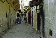
contains some of the largest auto-free areas in the world. Fes-al-Bali, a medina
Medina quarter
A medina quarter is a distinct city section found in many North African cities. The medina is typically walled, contains many narrow and maze-like streets...
of Fes
Fes
Fes or Fez is the second largest city of Morocco, after Casablanca, with a population of approximately 1 million . It is the capital of the Fès-Boulemane region....
, Morocco
Morocco
Morocco , officially the Kingdom of Morocco , is a country located in North Africa. It has a population of more than 32 million and an area of 710,850 km², and also primarily administers the disputed region of the Western Sahara...
, with its population of 156,000, may be the world's largest contiguous completely carfree area, and the medinas of Cairo
Cairo
Cairo , is the capital of Egypt and the largest city in the Arab world and Africa, and the 16th largest metropolitan area in the world. Nicknamed "The City of a Thousand Minarets" for its preponderance of Islamic architecture, Cairo has long been a centre of the region's political and cultural life...
, Casablanca
Casablanca
Casablanca is a city in western Morocco, located on the Atlantic Ocean. It is the capital of the Grand Casablanca region.Casablanca is Morocco's largest city as well as its chief port. It is also the biggest city in the Maghreb. The 2004 census recorded a population of 2,949,805 in the prefecture...
, Meknes
Meknes
Meknes is a city in northern Morocco, located from the capital Rabat and from Fes. It is served by the A2 expressway between those two cities and by the corresponding railway. Meknes was the capital of Morocco under the reign of Moulay Ismail , before it was relocated to Marrakech. The...
, Essaouira
Essaouira
Mogador redirects here, for the hamlet in Surrey see Mogador, Surrey.Essaouira is a city in the western Moroccan economic region of Marrakech-Tensift-Al Haouz, on the Atlantic coast. Since the 16th century, the city has also been known by its Portuguese name of Mogador or Mogadore...
, and Tangier
Tangier
Tangier, also Tangiers is a city in northern Morocco with a population of about 700,000 . It lies on the North African coast at the western entrance to the Strait of Gibraltar where the Mediterranean meets the Atlantic Ocean off Cape Spartel...
are quite extensive.
Australia
In AustraliaAustralia
Australia , officially the Commonwealth of Australia, is a country in the Southern Hemisphere comprising the mainland of the Australian continent, the island of Tasmania, and numerous smaller islands in the Indian and Pacific Oceans. It is the world's sixth-largest country by total area...
as in the US, these zones are commonly called pedestrian malls and in most cases comprise only one street. Most pedestrian streets were created in the late 1970s and 1980s, the first being City Walk, Garema Place in Canberra in 1971. Of 58 pedestrian streets created in Australia in the last quarter of the 20th century, 48 remain today, ten having re-introduced car access between 1990 and 2004. All capital cities in Australia have at least one pedestrian street of which most central are: Pitt Street Mall and Martin Place
Martin Place, Sydney
Martin Place, formerly known as Moore Street, is a pedestrian mall in the central business district of Sydney, New South Wales, Australia. Home to the Reserve Bank of Australia, the Commonwealth Bank of Australia, Macquarie Bank and other corporations, Martin Place is synonymous with corporate...
in Sydney, Bourke Street Mall
Bourke Street, Melbourne
Bourke Street is one of Melbourne's best known streets. Historically been regarded as Melbourne's "second street", with the main street being Collins Street and "busier than Bourke Street" is a popular catchphrase. Bourke Street has traditionally been Melbourne's entertainment hub...
in Melbourne, Queen Street Mall and Brunswick Street Mall in Brisbane, Rundle Mall in Adelaide, Hay Street
Hay Street, Perth
Hay Street is a major road through the CBD of Perth, Western Australia. The street was named after Robert William Hay, the Permanent Under Secretary for Colonies. Sections of the road were called Howick Street and Twiss Street until 1897...
and Murray Street
Murray Street, Perth
Murray Street is one of four main east-west roads within the Perth central business district.The street, the central portion of which has become a pedestrian mall, was named after Sir George Murray, Secretary of State for War and the Colonies from 1828 to 1830.It is the one main road in Perth that...
Malls in Perth, Elizabeth Street
Elizabeth Street, Hobart
Elizabeth Street is a major street which runs North-South through the city and suburbs of Hobart, Tasmania, Australia. It is named after Elizabeth Macquarie, the wife of the Governor of New South Wales from 1810-1821, Lachlan Macquarie....
in Hobart, City Walk
City Walk, Canberra
City Walk is a paved outdoor pedestrian area in Civic, Canberra. It was formed by the closure to traffic of Alinga Street between East Row in the east and Binara Street in the south-west...
in Canberra, and Smith Street
Smith Street, Darwin
Smith Street is a major street in the Darwin Central Business district of Darwin, Northern Territory, Australia. Smith Street is named after A. H. Smith who was the first surveyor in charge of party number 3 of George Goyder in 1869. Smith Street runs 4.5 kilometers northwest - southeast direction...
in Darwin. Many other mid-sized and regional Australian cities also feature pedestrian malls, examples include Langtree Avenue Mildura
Mildura, Victoria
Mildura is a regional city in northwestern Victoria, Australia and seat of the Rural City of Mildura local government area. It is located in the Sunraysia region, and is on the banks of the Murray River. The current population is estimated at just over 30,000.Mildura is a major agricultural centre...
, Bridge Street Ballarat
Ballarat, Victoria
Ballarat is a city in the state of Victoria, Australia, approximately west-north-west of the state capital Melbourne situated on the lower plains of the Great Dividing Range and the Yarrowee River catchment. It is the largest inland centre and third most populous city in the state and the fifth...
, Brisbane Street Ipswich
Ipswich, Queensland
Ipswich is a city in South-East Queensland, Australia. Situated along the Bremer River Valley approximately 40 kilometres away from the state's capital Brisbane. The suburb by the same name forms the city's Central Business District and administrative centre...
, Hargreaves Street Bendigo, Maude Street Shepparton
Shepparton, Victoria
Shepparton is a city located on the floodplain of the Goulburn River in the north east of Victoria, Australia approximately north-east of Melbourne. It is the fifth largest city in Victoria, Australia. The estimated population of Shepparton's statistical area is 48,926.It began as a sheep station...
and Little Mallop Street Geelong.
Empircial studies by Jan Gehl
Jan Gehl
Jan Gehl is a Danish architect and urban design consultant based in Copenhagen and whose career has focused on improving the quality of urban life by re-orienting city design towards the pedestrian and cyclist.-Biography:...
indicate an increase of pedestrian traffic as result of public domain improvements in the centres of Melbourne with 39% increase between 1994-2004 and Perth with 13% increase between 1993-2009.
Most intensive pedestrian traffic flows on a summer weekday have been recorded in Bourke Street Mall Melbourne with 81,000 pedestrians (2004), Rundle Mall Adelaide with 61,360 pedestrians (2002), Pitt Street Mall Sydney with 58,140 (2007) and Murray Street Mall Perth with 48,350 pedestrians (2009).
The island of Rottnest off Perth is a car free island, only allowing vehicles for essential services. The main form of transport on the island is bicycles, which can be hired or be taken on the ferry.
In Melbourne's north-eastern suburbs, there have been many proposals to make the Doncaster Hill
Doncaster Hill
Doncaster Hill is one of the highest points in the metropolitan area of Melbourne, Australia. Located in the suburb of Doncaster, it is 120 metres above sea level and has uninterrupted views of the city, Port Phillip, Macedon Ranges, the You Yang Ranges and Dandenong Ranges...
development area a pedestrian zone. If the proposals are passed, the zone could be one of the largest in the world, by area.
Neighbourhoods
Several dozen new carfree neighbourhoods have been built in recent decades, mostly in Europe. An example is Vauban, a neighbourhood of 5,000 in FreiburgFreiburg
Freiburg im Breisgau is a city in Baden-Württemberg, Germany. In the extreme south-west of the country, it straddles the Dreisam river, at the foot of the Schlossberg. Historically, the city has acted as the hub of the Breisgau region on the western edge of the Black Forest in the Upper Rhine Plain...
, Germany
Germany
Germany , officially the Federal Republic of Germany , is a federal parliamentary republic in Europe. The country consists of 16 states while the capital and largest city is Berlin. Germany covers an area of 357,021 km2 and has a largely temperate seasonal climate...
.
Problems caused by pedestrianisation
Pedestrianisation can cause problems of security and desolation, especially outside of normal business hours. Local businesses may be adversely affected by pedestrianisation due to reduced through traffic and footfall.There were calls for traffic to be reinstated in Trafalgar Square
Trafalgar Square
Trafalgar Square is a public space and tourist attraction in central London, England, United Kingdom. At its centre is Nelson's Column, which is guarded by four lion statues at its base. There are a number of statues and sculptures in the square, with one plinth displaying changing pieces of...
, London, after pedestrianisation caused noise nuisance
Noise pollution
Noise pollution is excessive, displeasing human, animal or machine-created environmental noise that disrupts the activity or balance of human or animal life...
for visitors to the National Gallery
National gallery
The National Gallery is an art gallery on Trafalgar Square, London, United Kingdom.National Gallery may also refer to:*Armenia: National Gallery of Armenia, Yerevan*Australia:**National Gallery of Australia, Canberra...
. The director of the gallery is reported to have blamed pedestrianisation for the "trashing of a civic space".
Local shop-keepers may be critical of the effect of pedestrianisation on the viability of their businesses. Reduced through traffic can lead to fewer customers using local businesses.
See also
- Car Free DaysCar Free DaysA Car Free Day encourages motorists to give up their car for a day. Organized events are held in some cities and countries. September 22 is World Car Free Day...
- Car-free movementCar-free movementThe car-free movement is a broad, informal, emergent network of individuals and organizations including social activists, urban planners and others brought together by a shared belief that cars are too dominant in most modern cities...
- FootpathFootpathA Footpath is a thoroughfare intended for by pedestrians but not by motorized vehicles. The term is often for paths within an urban area that offer shorter quieter routes for pedestrians, they may also provide access to the surrounding countryside or parks...
- List of car-free places
- Carfree city
- Living streetLiving streetA living street is a street in which, unlike in most 20th century streets, the needs of car drivers are secondary to the needs of users of the street as a whole. It is a space designed to be shared by pedestrians, playing children, bicyclists, and low-speed motor vehicles...
- Jan GehlJan GehlJan Gehl is a Danish architect and urban design consultant based in Copenhagen and whose career has focused on improving the quality of urban life by re-orienting city design towards the pedestrian and cyclist.-Biography:...
- Principles of Intelligent UrbanismPrinciples of Intelligent UrbanismPrinciples of Intelligent Urbanism is a theory of urban planning composed of a set of ten axioms intended to guide the formulation of city plans and urban designs. They are intended to reconcile and integrate diverse urban planning and management concerns...
- Bicycle CityBicycle CityBicycle City is a planned, car-free communities project with a mission to create sustainable places where people can live, work and visit. Parking is planned to be on the edge of the community near your home....