
Beagle Channel cartography since 1881
Encyclopedia
The region of the Beagle Channel
, explored by Robert FitzRoy
eighteen-thirties, was one of the last ones to be colonized
by Chile
and Argentina
. The cold weather, the long distances from other inhabited regions and the shortage of transport and subsistence kept it far from the governmental task.
In the map
s exhibited in this page it is possible to appreciate the lacking knowledge of the geography
by navigators and explorers of the zone and also the statesmen who had to decide on the borders. Nevertheless, when the Boundary treaty of 1881 between Chile and Argentina was signed, in the Beagle Channel zone at least the main islands and waterways were known.
The Beagle Channel Arbitration Court
reviewed in-depth the cartography of the zone and stated that:
All Chilean maps have shown always the islands as Chilean territories, like the map of engineer Alejandro Bertrand showed here. This border line is today valid for both countries.
There were some few dissentient maps in this period, but the Court declared it untrustworthy because of its "excentric" borderline. (see below).
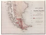
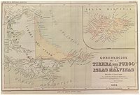
 Partial reproduction of the first Argentine map showing the boundaries laid down in the Boundary Treaty of 23 July 1881, appeared in "La Ilustracion Argentina" issue of 10 November 1881 in Buenos Aires
. The copy reproduced here is one handed to the British Minister Plenipontentiary in Buenos Aires by Dr. Bernardo de Irigoyen
, Argentine Minister of Foreign Affairs who negotiated and signed the Boundary Treaty. The original is located in the official British Archives. The British Minister sent it to his Government with the comment that the dark shaded area "comprising the Strait of Magellan, half of Tierra del Fuego and all the southern islands, represent was actually has been ceded to Chile by the recent Treaty." (under Irigoyen map)
 This map partially reproduced here is regarded by Chile as first official Argentine map after the Boundary Treaty of 1881, though its official character was subsequently denied by the Argentine Government. It was ordered to be drawn up by the then Argentine Minister of the Interior, Bernardo de Irigoyen (who has previously been Minister of Foreign Affairs in which quality he has signed the Boundary Treaty of 1881) for inclusion in an official publication issued by the Director of the National Statistics Office, Dr. Francisco Latzina, in 1883 under the title "The Argentine Republic as a field for European Immigration" (under Latzina map of 1882). This was published in Spanish
, English
, German
, French
and Italian
in an edition of 120.000 copies. On the official map all the islands located south of the Beagle Channel are shown under Chilean Sovereignty.
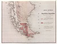
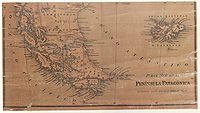
 This official map of Chile, partially reproduced here, «was drawn up on the orders of the Chilean Government for use in primary schools in the Republic and with a view to the most recent data» by Alejandro Bertrand in 1884. The author, an engineer, was member of the Boundary Commissions charged with marking out the Chilean-Argentine Frontier. At the time the map was approved by the Chilean Hydrographic Office. On the map all the islands south of the Beagle Channel as far as Cape Horn are shown as being under Chilean sovereignty. All Chilean maps have shown this border line since 1881.
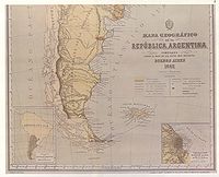
 In 1882 the Argentine Geographic Institute decided to issue a general map and an atlas
of the Argentine Republic. The task was put in the hands of the well known Professor of the (Argentine) University of Córdoba, Arturo Seelstrang, who had already brought out a map of the Republic in 1875. The Atlas was «constructed and published» by the institute «under the auspices of the National Government». Plate XXVII of the Atlas, reproduced here, was headed «Governoship of Tierra del Fuego and the Malvinas Islands» and were drawn up in 1885 and published the following year. As may be observed, said map shows the boundary line running through the centre of the Beagle Channel, indicating Picton, Nueva and Lennox Islands an all the other islands and islets extending southwards as far as Cape Horn as being under Chilean sovereignty.
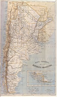
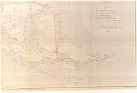
 General Map of the Argentine Republic and neighbouring countries, 1886. The map shown here states that it was «made according to the latest official data» and «in the light of the latest plans and sketches» by Francisco Moreno
, Argentine expert on the Commission for marking out the frontier with Chile, and by Lieutenant-Colonel José Olascoaga, Head of the "Military Typographic Office".
At the bottom, right, the map bears the inscription in the Library of Congress
.
As may be observed, the international boundary is traced along the centre of the Beagle Channel, showing Picton, Nueva and Lennox and all the other islands and islets extending southwards as far as Cape Horn as being under Chilean sovereignty.
 This map, reproduced here, is included in the book «Geography of the Argentine Republic» ("Geografía de la República Argentina") published in Buenos Aires in 1888, editorial Lajouane, by Francisco Latzina, National Director of the «Argentine Statistics Institute» and member of numerous scientific societies. «This work obtained the "Rivadavia Award" [Gran Premio Bernardino Rivadavia] of the "Argentine Geographic Institute" and a large number of copies of it where ordered by the Argentine authorities for distribution in Europe and elsewhere.» The jury was conformed by Estanislao Zeballos, Bartolomé Mitre
, Julio Argentino Roca
, Domingo Faustino Sarmiento
, Guillermo Rawson
and Lucio V. Mansilla.
In the extreme southern region, the international boundary is traced along the centre of the Beagle Channel and stretches to the south of the Isla de los Estados. Here it shows Picton, Nueva and Lennox Islands and all other islands and islets extending southward as far as Cape Horn as being under Chilean sovereignty.
 The Peru
vian geographer Mariano Felipe Paz Soldán
, who sought refuge in Buenos Aires
during the disastrous War of the Pacific
between Peru and Chile, drew 1888, amongst others, two maps of Argentina:
The relevant sections of the maps are shown on the left side.
The "Mapa orohidrográfico" shows the Islands "Picton" and "Nueva" as under Argentine und the Island "Lennox" as under Chilean sovereignty. In contrast, the "Mapa general" shows all disputed islands as Chilean territories.
This and other turnarounds (see below) of Paz Soldáns Interpretation of the 1881 Boundary Treaty caused the Arbitral Court
to discard his maps from the documentary evidence.
Other maps of Paz Soldán show the disputed islands as Chilean Territories:
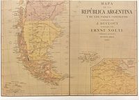 The map partially reproduced here was drawn up in Buenos Aires in 1889 by J. Duclout and published by E. Nolte.
In the southern region the international boundary is shown traced through the centre of the Beagle channel, continuing beyond the eastern mouth of the Channel, indicating Picton, Nueva and Lennox Islands and all other islands and islets extending southward as far as Cape Horn as being under Chilean sovereignty
Island forth to the Antarctic
, «a fanciful line unrelated to the Treaty basis of division» as stated by the Court of Arbitration. In 1891, the Argentine Government created an "International Boundaries Office" at the Ministry of Foreign Affairs and in 1893 issued other decree providing that works on national geography already published should not be considered as officially approved unless accompanied by a "special statement" from the Department of Foreign Affairs.
In 1889 appeared the "Carte de la République Argentine" as part of "L'Agriculture et l'Elevage dans la République Argentine", officially sponsored for the purposes of the Argentine participation in the Paris World Exhibition of 1889
. In the work of which this map was a part, the
version there given of the article III of the 1881 Treaty (Argentine attribution in the Islands clause), was seriously incorrect:
instead of the original text:
 ]
]
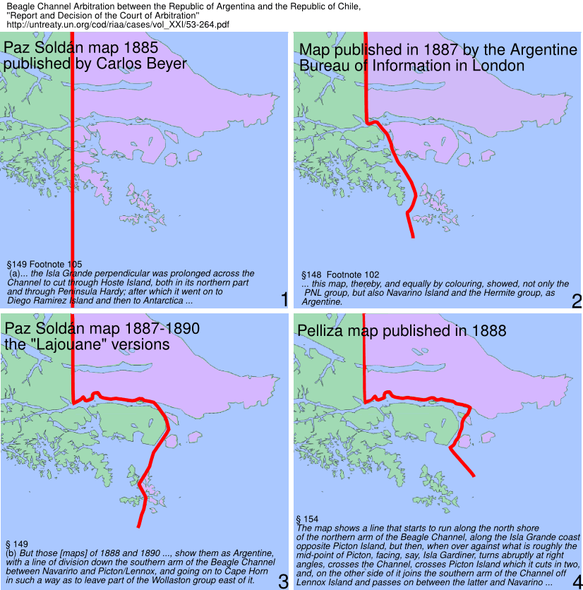
By the review of the cartography, the tribunal refused the validity of 3 in Argentina and 1 in London
(by the Argentine Embassy) published maps. The maps are not disponible for now, but the court gave to every refuse a briefly map description (see text on the maps) that allowed us to rebuild the border line as showed at the left side.
In order to decide the vadility of a map the court used following criterion for exclusion:
The refused maps are:
1 Paz Soldán Map 1885, published by Carlos Beyer: This version prolonged the perpendicular to the Antarctic and was discarded: «this map, equally, showed a fanciful line unrelated to the Treaty basis of division».
2 Map published in 1887 by the Argentine Bureau of Information in London: The footnote 102 regards to this map. It was refused with the argument: «a completely fanciful line division that could have no possible warrant under the of 1881 Treaty». The map was corrected by the same Bureau on its map of the next year and the corrected map is linked here.
3 The "Lajouane" versions of the Paz Soldán maps This versions were published between 1887 and 1890: altogether we know 4 different interpretations of Paz Soldán of the 1881 Treaty, see section "Two maps of Argentina, Mariano Paz Soldán, 1888", (above), and two here (left). Such turnaround lead the tribunal to the conclusion: «Two volte-faces of this kind within one five-year period -for which no explanation seems to have been offered- must throw doubt on the credibility of the whole series of Paz Soldán based maps. It also raises the question of the reason for it.».
4 The Pelliza map was published 1888 and presented to the Court by Argentina as the first official Argentine map that represented the border line according to the 1881 Treaty.. There were several slight different versions of this map, by some ones the border line runs over the north shore of the channel and by others on the south shore of the channel. The Court refused this maps with following words: «This result [border line], even if not absolutely underivable from any possible interpretation of the Treaty, is so eccentric that it can hardly be taken seriously».
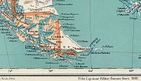
 This partially reproduced map corresponds to that titled Preliminary Map of the Southern Region of the Argentine Republic which was included as No. XIV in the Argentine Evidence submitted by the Argentine Government to British Arbitration in 1898-1902. It is the first official map of Argentina showing in the area of the Beagle Channel a different frontier from the one established in the Boundary Treaty with Chile of 1881. As may be seen from the map, the boundary line deviates from the Beagle Channel towards Picton and Richmond Passages to end up between Lennox and Nueva Islands. In that way Picton and Nueva Islands appear as Argentine and Lennox Island as Chilean. The islands and islets extending southward as far as Cape Horn continue to be shown as under Chilean sovereignty. It should be recalled that there was no question concerning the territories to the south of the Magellan Strait in the British Arbitration of 1898-1902. Thus neither Chile nor Argentina made any specific reference to the boundary shown on the Argentine map reproduced here.
n adventurer Julio Popper gave a speech at the "Instituto Geográfico Argentino" (predecessor of Instituto Geográfico Militar) about a change of course of the Beagle channel: the channel didn't reach the Cape San Pío but at the "Punta Navarro" flows to the south through the Navarino and Picton islands. 1899 ordered the Argentine navy the ship ARA Almirante Brown (1880)
under the command of Captain Juan P. Saenz Valiente on a hydrographic survey
of the Beagle channel. The Argentine survey corroborated the Argentine thesis
about the change of the Beagle and therefore the institut published 1901 new charts of the zone with a new Toponymy
. They expanded the Moat-Bay (Bahía Moat), located at the shore of the Tierra del Fuego, opposite to the Picton island, to a (new) Moat channel. The new channel reached from Punta Navarro to Cabo San Pío. Consequently the Picton, Nueva and Lennox islands became Terra Nullius
, because the treaty of 1881 at this zone doesn't mention other islands than "south of the Beagle channel". The toponymy was disclosed to the United Kingdom
and to the United States of America. Chile, the immediate neighbour was not informed and was advised of the new names only 1904 through new charts of the zone edited by the USA. Segundo R. Storni, then Leutnant later (1943) Foreign Ministers of Argentina legitimated the modifications:
The new name didn't prevail and disappeared into oblivion. The Treaty of Peace and Friendship of 1984 between Chile and Argentina
mention (only) the Beagle channel.
 This map, whose southern part is reproduced here, is included in Col. Sir Thomas Holdich
's work "The Countries of the King's Award" written immediately after his work on the British Arbitration in 1898-1902. After the British Arbitral Award of 1902 and during the course of the work marking out the frontier line indicated therein, Holdich visited the Beagle Channel zone which was not included in the arbitration. In the Beagle Channel region the map marks the international boundary as passing through the latter up to beyond its eastern mouth. Picton, Nueva and Lennox Islands and all the other islands extending southwards as far as Cape Horn are shown as under Chilean sovereignty.
Other Europeans maps showing the same zone:
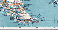
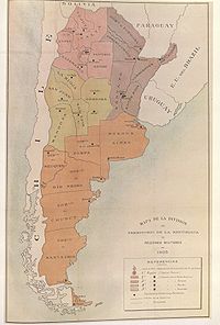 This reproduction of the map 'Map of the division of the Argentine territory into Military regions 1905' was included in the Military Bulletin of the Argentine Ministry of War, Year IV, vol. I, 1 May 1905, No. 140. The Argentine military regions are distinguished by different colours, all territories located south of the Beagle Channel as far as Cape Horn have been omitted and thus understood to be under Chilean sovereignty.
 Partial reproduction of the "Nuevo Mapa de la República Argentina", 1914, prepared by por Pablo Ludwig. The complete map is under Nuevo mapa de la República Argentina (1914) Picton and Nueva appear under Argentine, Lennox under Chilean sovereignty.
 Rebuild of the sheet 'Ushuaia' from the :es:Instituto Geográfico Militar (Argentina), 1967 edition. Only the borderline and the oceanic Toponymy are copied from the copyrighted original. A similar map was issued in 1948.
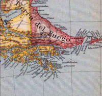
The international boundary shown in the Beagle Channel zone corresponds to the Argentine claim in the area which the arbitral decision of 18 April 1977 put a definitive end. Nueva Island is not shown on the map, and Picton and Lennox Islands are partially shown, coloured as belonging to the Argentine Republic. Nevertheless all the other islands and islets extending southward as far as Cape Horn figure as under Chilean sovereignty.
Curiously in the official Argentine map the geographic nomenclature "OCÉANO ATLÁNTICO SUR" (South Atlantic Ocean) appears inserted to the south of Hoste Island and in the western region of Wollaston
and Hermite Islands
, in other words more than one degree longitude west of Cape Horn, thus contradicting the (1978) Argentine thesis concerning the ocean toponymy in the region of the extreme south of America, that the Cape Horn was the border between the Pacific and Atlantic Ocean.
 This image shows a facsimile of the map appeared in the cover of the book compiled by of Admiral (R) Isaac Rojas
, former vice-president of Argentina and former Chief of the Argentine Navy, and Arturo Medrano "Argentina en el Atlántico Chile en el Pacífico". It is approved by the Argentine Ministry of Education for teaching in schools and high schools.
The book justifies, as they say, the Argentine claim over the islands. Not only Picton, Nueva, Lennox and all islands east from Cape Horn meridian are Argentine Territories but also the east side of Navarino Island with the Chilean village of Puerto Toro
appears under Argentine sovereignty.
 During the Falklands War
, after the sinking of ARA General Belgrano
, the Buenos Aires newspaper Clarín
published, on 4. May 1982, a detailed map of the zone, with a scale
, geographic coordinates
, a general location map and a little map with the Argentine claim over the Antarctic
in order to explain the war event to the reader. The black circle with the number "1" shows the place where the ARA Belgrano sunk. The circle with the number "2" shows the place of the last radio contact with the Argentine ship ARA Alferez Sobral
. The full first page of the newspaper can be seen under El historiador.
The original map is approximately 25 cm width and 25 cm height and contains the names of the main islands of the conflict with Chile: Picton, Nueva, Lennox and Cape Horn (Cabo de Hornos).
In this map all islands south and east of Navarino island appear then under Argentine sovereignty: Picton, Nueva, Lennox, Freycinet, Deceit, Wollaston, Hall, Cape Horn, Hermite, Herschel, Gratil, Grevy, Bayly, Augustus, Snipe, Terhalten, Jerdam, etc. At that time Argentina requested Chilean support at the TIAR
against the United Kingdom
.
1983, after the war, Argentina issued a postage stamp
to commemorate "the first" reconquest of the Falkland Islands. The stamps shows explicit the Cape Horn Island
with an Argentine label.
 The contrast could hardly be starker between the multiple Argentine views and the sole Chilean view of the 1881 Boundary Treaty. The interpretation of the 1881 Boundary Treaty seems to have challenged to the limit the fantasy and intelligence of the Argentine cartography as of 1888, for they found more than 9 different border lines from the same text. Anyway, in his Report and Decision on 18 April 1977 the Court of Arbitration judged:
Argentine scientists Carlos Escudé
and Andrés Cisneros in Historia general de las relaciones exteriores de la República Argentina give a résumé of the Boundary Treaty of 1881:
The same opinion shares the authors Karl Hernekamp, Annegret I. Haffa and Andrea Wagner in their works mentioned in the reference.
In 1904 the Argentine government solicited to the Chilean government a common demarcation of the border line in the Beagle Channel.
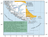
Beagle Channel
thumb|right|300px|Aereal view of Beagle Channel. The Chilean [[Navarino Island]] is seen in the top-right while the Argentine part of [[Isla Grande de Tierra del Fuego]] is seen at the bottom-left....
, explored by Robert FitzRoy
Robert FitzRoy
Vice-Admiral Robert FitzRoy RN achieved lasting fame as the captain of HMS Beagle during Charles Darwin's famous voyage, and as a pioneering meteorologist who made accurate weather forecasting a reality...
eighteen-thirties, was one of the last ones to be colonized
Settler
A settler is a person who has migrated to an area and established permanent residence there, often to colonize the area. Settlers are generally people who take up residence on land and cultivate it, as opposed to nomads...
by Chile
Chile
Chile ,officially the Republic of Chile , is a country in South America occupying a long, narrow coastal strip between the Andes mountains to the east and the Pacific Ocean to the west. It borders Peru to the north, Bolivia to the northeast, Argentina to the east, and the Drake Passage in the far...
and Argentina
Argentina
Argentina , officially the Argentine Republic , is the second largest country in South America by land area, after Brazil. It is constituted as a federation of 23 provinces and an autonomous city, Buenos Aires...
. The cold weather, the long distances from other inhabited regions and the shortage of transport and subsistence kept it far from the governmental task.
In the map
Map
A map is a visual representation of an area—a symbolic depiction highlighting relationships between elements of that space such as objects, regions, and themes....
s exhibited in this page it is possible to appreciate the lacking knowledge of the geography
Geography
Geography is the science that studies the lands, features, inhabitants, and phenomena of Earth. A literal translation would be "to describe or write about the Earth". The first person to use the word "geography" was Eratosthenes...
by navigators and explorers of the zone and also the statesmen who had to decide on the borders. Nevertheless, when the Boundary treaty of 1881 between Chile and Argentina was signed, in the Beagle Channel zone at least the main islands and waterways were known.
The Beagle Channel Arbitration Court
Beagle Channel Arbitration
On 22 July 1971 Salvador Allende and Alejandro Lanusse, the Presidents of Chile and Argentina, signed an arbitration agreement . This agreement related to their dispute over the territorial and maritime boundaries between them, and in particular the title to the Picton, Nueva and Lennox islands...
reviewed in-depth the cartography of the zone and stated that:
- §163
- Finally, the Court wishes to stress again that its conclusion to the effect that the PNL [Picton, Nueva and Lennox Islands] group is Chilean according to the 1881 Treaty has been reached on the basis of its interpretation of the Treaty, especially as set forth in paragraphs 55-111 above, and independently of the cartography of the case which has been taken account of only for purposes of confirmation or corrobation. The same applies in respect of the particular maps discussed in, and from, paragraph 119 onwards.
The concordant Interpretation of the 1881 Boundary Treaty from 1881 to 1888
From 1881 to 1888 show almost all Argentine maps the Picton, Lennox and Nueva islands as Chilean Territories.All Chilean maps have shown always the islands as Chilean territories, like the map of engineer Alejandro Bertrand showed here. This border line is today valid for both countries.
There were some few dissentient maps in this period, but the Court declared it untrustworthy because of its "excentric" borderline. (see below).
Map in "La Ilustración Argentina", 1881
Buenos Aires
Buenos Aires is the capital and largest city of Argentina, and the second-largest metropolitan area in South America, after São Paulo. It is located on the western shore of the estuary of the Río de la Plata, on the southeastern coast of the South American continent...
. The copy reproduced here is one handed to the British Minister Plenipontentiary in Buenos Aires by Dr. Bernardo de Irigoyen
Bernardo de Irigoyen
Bernardo de Irigoyen was an Argentine lawyer, diplomat and politician.-Biography:Born in Buenos Aires, Irigoyen enrolled at the University of Buenos Aires and earned a juris doctor in 1843...
, Argentine Minister of Foreign Affairs who negotiated and signed the Boundary Treaty. The original is located in the official British Archives. The British Minister sent it to his Government with the comment that the dark shaded area "comprising the Strait of Magellan, half of Tierra del Fuego and all the southern islands, represent was actually has been ceded to Chile by the recent Treaty." (under Irigoyen map)
Map of Francisco Latzina, 1882
Spanish language
Spanish , also known as Castilian , is a Romance language in the Ibero-Romance group that evolved from several languages and dialects in central-northern Iberia around the 9th century and gradually spread with the expansion of the Kingdom of Castile into central and southern Iberia during the...
, English
English language
English is a West Germanic language that arose in the Anglo-Saxon kingdoms of England and spread into what was to become south-east Scotland under the influence of the Anglian medieval kingdom of Northumbria...
, German
German language
German is a West Germanic language, related to and classified alongside English and Dutch. With an estimated 90 – 98 million native speakers, German is one of the world's major languages and is the most widely-spoken first language in the European Union....
, French
French language
French is a Romance language spoken as a first language in France, the Romandy region in Switzerland, Wallonia and Brussels in Belgium, Monaco, the regions of Quebec and Acadia in Canada, and by various communities elsewhere. Second-language speakers of French are distributed throughout many parts...
and Italian
Italian language
Italian is a Romance language spoken mainly in Europe: Italy, Switzerland, San Marino, Vatican City, by minorities in Malta, Monaco, Croatia, Slovenia, France, Libya, Eritrea, and Somalia, and by immigrant communities in the Americas and Australia...
in an edition of 120.000 copies. On the official map all the islands located south of the Beagle Channel are shown under Chilean Sovereignty.
Official map of the Republic of Chile, 1883
Map of the "Instituto Geográfico Argentino", 1886
Atlas
An atlas is a collection of maps; it is typically a map of Earth or a region of Earth, but there are atlases of the other planets in the Solar System. Atlases have traditionally been bound into book form, but today many atlases are in multimedia formats...
of the Argentine Republic. The task was put in the hands of the well known Professor of the (Argentine) University of Córdoba, Arturo Seelstrang, who had already brought out a map of the Republic in 1875. The Atlas was «constructed and published» by the institute «under the auspices of the National Government». Plate XXVII of the Atlas, reproduced here, was headed «Governoship of Tierra del Fuego and the Malvinas Islands» and were drawn up in 1885 and published the following year. As may be observed, said map shows the boundary line running through the centre of the Beagle Channel, indicating Picton, Nueva and Lennox Islands an all the other islands and islets extending southwards as far as Cape Horn as being under Chilean sovereignty.
General Map of the Argentine Republic and neighbouring countries, 1886
Francisco Moreno
Francisco Pascacio Moreno was a prominent explorer and academic in Argentina, where he is usually referred to as Perito Moreno...
, Argentine expert on the Commission for marking out the frontier with Chile, and by Lieutenant-Colonel José Olascoaga, Head of the "Military Typographic Office".
At the bottom, right, the map bears the inscription in the Library of Congress
Library of Congress
The Library of Congress is the research library of the United States Congress, de facto national library of the United States, and the oldest federal cultural institution in the United States. Located in three buildings in Washington, D.C., it is the largest library in the world by shelf space and...
.
As may be observed, the international boundary is traced along the centre of the Beagle Channel, showing Picton, Nueva and Lennox and all the other islands and islets extending southwards as far as Cape Horn as being under Chilean sovereignty.
Map of Francisco Latzina, 1888
Bartolomé Mitre
Bartolomé Mitre Martínez was an Argentine statesman, military figure, and author. He was the President of Argentina from 1862 to 1868.-Life and times:...
, Julio Argentino Roca
Julio Argentino Roca
Alejo Julio Argentino Roca Paz was an army general who served as President of Argentina from 12 October 1880 to 12 October 1886 and again from 12 October 1898 to 12 October 1904.-Upbringing and early career:...
, Domingo Faustino Sarmiento
Domingo Faustino Sarmiento
Domingo Faustino Sarmiento was an Argentine activist, intellectual, writer, statesman and the seventh President of Argentina. His writing spanned a wide range of genres and topics, from journalism to autobiography, to political philosophy and history...
, Guillermo Rawson
Guillermo Rawson
Dr. Guillermo Rawson was a medical doctor and politician in nineteenth-century Argentina. As Interior Minister in 1862 he met Captain Love Jones-Parry and Lewis Jones who were on their way to Patagonia to investigate whether it was suitable for the creation of a Welsh settlement there...
and Lucio V. Mansilla.
In the extreme southern region, the international boundary is traced along the centre of the Beagle Channel and stretches to the south of the Isla de los Estados. Here it shows Picton, Nueva and Lennox Islands and all other islands and islets extending southward as far as Cape Horn as being under Chilean sovereignty.
Two maps of Argentina, Mariano Paz Soldán, 1888
Peru
Peru , officially the Republic of Peru , is a country in western South America. It is bordered on the north by Ecuador and Colombia, on the east by Brazil, on the southeast by Bolivia, on the south by Chile, and on the west by the Pacific Ocean....
vian geographer Mariano Felipe Paz Soldán
Mariano Felipe Paz Soldan
Mariano Felipe Paz Soldán , Peruvian historian and geographer, was born at Arequipa, Peru.-Education and early career:He studied law and, after holding some minor judicial offices, was minister to New Granada in 1853...
, who sought refuge in Buenos Aires
Buenos Aires
Buenos Aires is the capital and largest city of Argentina, and the second-largest metropolitan area in South America, after São Paulo. It is located on the western shore of the estuary of the Río de la Plata, on the southeastern coast of the South American continent...
during the disastrous War of the Pacific
War of the Pacific
The War of the Pacific took place in western South America from 1879 through 1883. Chile fought against Bolivia and Peru. Despite cooperation among the three nations in the war against Spain, disputes soon arose over the mineral-rich Peruvian provinces of Tarapaca, Tacna, and Arica, and the...
between Peru and Chile, drew 1888, amongst others, two maps of Argentina:
- (above) «Mapa Orohidrográfico de la República Argentina» (see full size map) and
- (below) «Mapa general de la República Argentina» (see full size map).
The relevant sections of the maps are shown on the left side.
The "Mapa orohidrográfico" shows the Islands "Picton" and "Nueva" as under Argentine und the Island "Lennox" as under Chilean sovereignty. In contrast, the "Mapa general" shows all disputed islands as Chilean territories.
This and other turnarounds (see below) of Paz Soldáns Interpretation of the 1881 Boundary Treaty caused the Arbitral Court
Beagle Channel Arbitration
On 22 July 1971 Salvador Allende and Alejandro Lanusse, the Presidents of Chile and Argentina, signed an arbitration agreement . This agreement related to their dispute over the territorial and maritime boundaries between them, and in particular the title to the Picton, Nueva and Lennox islands...
to discard his maps from the documentary evidence.
Other maps of Paz Soldán show the disputed islands as Chilean Territories:
- «Gobernación de la Tierra del Fuego y las Islas Malvinas» (see full size map) and
- «Mapa de Tierra del Fuego y Malvinas» (see full size map)
Map of the Argentine Republic and neighbouring Countries, 1889
In the southern region the international boundary is shown traced through the centre of the Beagle channel, continuing beyond the eastern mouth of the Channel, indicating Picton, Nueva and Lennox Islands and all other islands and islets extending southward as far as Cape Horn as being under Chilean sovereignty
The Argentine change of policy
In the course of time became noticeable in Argentina a position that worked continuously towards a new interpretation of the Boundary Treaty. For example, in 1885 appeared a map of Mariano Paz Soldán that continued the perpendicular in the Tierra del FuegoTierra del Fuego
Tierra del Fuego is an archipelago off the southernmost tip of the South American mainland, across the Strait of Magellan. The archipelago consists of a main island Isla Grande de Tierra del Fuego divided between Chile and Argentina with an area of , and a group of smaller islands including Cape...
Island forth to the Antarctic
Antarctic
The Antarctic is the region around the Earth's South Pole, opposite the Arctic region around the North Pole. The Antarctic comprises the continent of Antarctica and the ice shelves, waters and island territories in the Southern Ocean situated south of the Antarctic Convergence...
, «a fanciful line unrelated to the Treaty basis of division» as stated by the Court of Arbitration. In 1891, the Argentine Government created an "International Boundaries Office" at the Ministry of Foreign Affairs and in 1893 issued other decree providing that works on national geography already published should not be considered as officially approved unless accompanied by a "special statement" from the Department of Foreign Affairs.
In 1889 appeared the "Carte de la République Argentine" as part of "L'Agriculture et l'Elevage dans la République Argentine", officially sponsored for the purposes of the Argentine participation in the Paris World Exhibition of 1889
Exposition Universelle (1889)
The Exposition Universelle of 1889 was a World's Fair held in Paris, France from 6 May to 31 October 1889.It was held during the year of the 100th anniversary of the storming of the Bastille, an event traditionally considered as the symbol for the beginning of the French Revolution...
. In the work of which this map was a part, the
version there given of the article III of the 1881 Treaty (Argentine attribution in the Islands clause), was seriously incorrect:
- «…appartiendront à la République Argentine : l'île de los Estados, les îlots qui l'entourent et les autres îles de l'Atlantique au sud de la Terre de Feu et des côtes orientales de la Patagonie…» (stress added by Wikipedia) (stress added by Wikipedia)
instead of the original text:
- «…to the Argentine Republic shall belong Staten Island, the small islands next to it, and the other islands on the Atlantic to the east of Tierra del Fuego and of the eastern coast of Patagonia…» (stress added by Wikipedia)
By the review of the cartography, the tribunal refused the validity of 3 in Argentina and 1 in London
London
London is the capital city of :England and the :United Kingdom, the largest metropolitan area in the United Kingdom, and the largest urban zone in the European Union by most measures. Located on the River Thames, London has been a major settlement for two millennia, its history going back to its...
(by the Argentine Embassy) published maps. The maps are not disponible for now, but the court gave to every refuse a briefly map description (see text on the maps) that allowed us to rebuild the border line as showed at the left side.
In order to decide the vadility of a map the court used following criterion for exclusion:
- Footnote 102
- Th¡s in two respects: (i) since under the first part of Article III of the Treaty, the perpendicular in the Isla Grande of Tierra del Fuego, from Cape Espíritu Santo to the Beagle Channel, was deliberately stopped there, a map showing a line of division which, by prolonging the perpendicular, crossed the Channel, and proceeded southward through the Murray Sound and past the Wollaston group, could not possibly represent the division contemplated by the Treaty; (ii) this map, thereby, and equally by colouring, showed, not only the PNL group, but also Navarino Island and the Hermite group, as Argentine. But these localities were "to the south of the Beagle Channel" according to any possible interpretation of that phrase in the Chilean attribution under the Islands clause of the Treaty.
The refused maps are:
1 Paz Soldán Map 1885, published by Carlos Beyer: This version prolonged the perpendicular to the Antarctic and was discarded: «this map, equally, showed a fanciful line unrelated to the Treaty basis of division».
2 Map published in 1887 by the Argentine Bureau of Information in London: The footnote 102 regards to this map. It was refused with the argument: «a completely fanciful line division that could have no possible warrant under the of 1881 Treaty». The map was corrected by the same Bureau on its map of the next year and the corrected map is linked here.
3 The "Lajouane" versions of the Paz Soldán maps This versions were published between 1887 and 1890: altogether we know 4 different interpretations of Paz Soldán of the 1881 Treaty, see section "Two maps of Argentina, Mariano Paz Soldán, 1888", (above), and two here (left). Such turnaround lead the tribunal to the conclusion: «Two volte-faces of this kind within one five-year period -for which no explanation seems to have been offered- must throw doubt on the credibility of the whole series of Paz Soldán based maps. It also raises the question of the reason for it.».
4 The Pelliza map was published 1888 and presented to the Court by Argentina as the first official Argentine map that represented the border line according to the 1881 Treaty.. There were several slight different versions of this map, by some ones the border line runs over the north shore of the channel and by others on the south shore of the channel. The Court refused this maps with following words: «This result [border line], even if not absolutely underivable from any possible interpretation of the Treaty, is so eccentric that it can hardly be taken seriously».
First Argentine official map with a different line of the border, 1898
The Moat channel
After the discovery of gold in Tierra del Fuego the RomaniaRomania
Romania is a country located at the crossroads of Central and Southeastern Europe, on the Lower Danube, within and outside the Carpathian arch, bordering on the Black Sea...
n adventurer Julio Popper gave a speech at the "Instituto Geográfico Argentino" (predecessor of Instituto Geográfico Militar) about a change of course of the Beagle channel: the channel didn't reach the Cape San Pío but at the "Punta Navarro" flows to the south through the Navarino and Picton islands. 1899 ordered the Argentine navy the ship ARA Almirante Brown (1880)
ARA Almirante Brown (1880)
ARA Almirante Brown was a warship of the Argentine Navy built in 1880 and serving until 1932.Built in London by Samuda Brothers, the Almirante Brown displaced 4200 tons, could call upon a total of , and had a nominal speed of fourteen knots. The ship was protected by a belt of nine-inch steel-faced...
under the command of Captain Juan P. Saenz Valiente on a hydrographic survey
Hydrographic survey
Hydrographic survey is the science of measurement and description of features which affect maritime navigation, marine construction, dredging, offshore oil exploration/drilling and related disciplines. Strong emphasis is placed on soundings, shorelines, tides, currents, sea floor and submerged...
of the Beagle channel. The Argentine survey corroborated the Argentine thesis
Thesis
A dissertation or thesis is a document submitted in support of candidature for an academic degree or professional qualification presenting the author's research and findings...
about the change of the Beagle and therefore the institut published 1901 new charts of the zone with a new Toponymy
Toponymy
Toponymy is the scientific study of place names , their origins, meanings, use and typology. The word "toponymy" is derived from the Greek words tópos and ónoma . Toponymy is itself a branch of onomastics, the study of names of all kinds...
. They expanded the Moat-Bay (Bahía Moat), located at the shore of the Tierra del Fuego, opposite to the Picton island, to a (new) Moat channel. The new channel reached from Punta Navarro to Cabo San Pío. Consequently the Picton, Nueva and Lennox islands became Terra Nullius
Terra nullius
Terra nullius is a Latin expression deriving from Roman law meaning "land belonging to no one" , which is used in international law to describe territory which has never been subject to the sovereignty of any state, or over which any prior sovereign has expressly or implicitly relinquished...
, because the treaty of 1881 at this zone doesn't mention other islands than "south of the Beagle channel". The toponymy was disclosed to the United Kingdom
United Kingdom
The United Kingdom of Great Britain and Northern IrelandIn the United Kingdom and Dependencies, other languages have been officially recognised as legitimate autochthonous languages under the European Charter for Regional or Minority Languages...
and to the United States of America. Chile, the immediate neighbour was not informed and was advised of the new names only 1904 through new charts of the zone edited by the USA. Segundo R. Storni, then Leutnant later (1943) Foreign Ministers of Argentina legitimated the modifications:
- The word "Bay" hasn't a precise signification and the configuration of the region inclines the meaning to a channel, so it is a logical modification. But we recognize that it wasn't absolutely necessary..
The new name didn't prevail and disappeared into oblivion. The Treaty of Peace and Friendship of 1984 between Chile and Argentina
Treaty of Peace and Friendship of 1984 between Chile and Argentina
The Treaty of Peace and Friendship of 1984 between Chile and Argentina was signed into agreement at the Vatican on 29 November 1984.It was ratified...
mention (only) the Beagle channel.
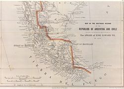
The southern regions of the Republics of Argentina and Chile, 1904
Thomas Holdich
Colonel Sir Thomas Hungerford Holdich, KCMG, KCIE, CB was an English geographer and president of the Royal Geographical Society. He is best known as Superintendent of Frontier Surveys in British India and author of numerous books, including The Gates of India, The Countries of the King's Award and...
's work "The Countries of the King's Award" written immediately after his work on the British Arbitration in 1898-1902. After the British Arbitral Award of 1902 and during the course of the work marking out the frontier line indicated therein, Holdich visited the Beagle Channel zone which was not included in the arbitration. In the Beagle Channel region the map marks the international boundary as passing through the latter up to beyond its eastern mouth. Picton, Nueva and Lennox Islands and all the other islands extending southwards as far as Cape Horn are shown as under Chilean sovereignty.
Other Europeans maps showing the same zone:
- Stieler Handatlas 1889
- La grande Encyclopedie 1890
- Stieler Handatlas 1891
- Atlante Mondiale Hoepli 1899
Map of the Argentine Army, 1905
"Nuevo Mapa de la República Argentina". Oficina de Cartografía Argentina, 1914
Sheet 'Ushuaia' from "Instituto Geográfico Militar de Argentina", 1967
The international boundary shown in the Beagle Channel zone corresponds to the Argentine claim in the area which the arbitral decision of 18 April 1977 put a definitive end. Nueva Island is not shown on the map, and Picton and Lennox Islands are partially shown, coloured as belonging to the Argentine Republic. Nevertheless all the other islands and islets extending southward as far as Cape Horn figure as under Chilean sovereignty.
Curiously in the official Argentine map the geographic nomenclature "OCÉANO ATLÁNTICO SUR" (South Atlantic Ocean) appears inserted to the south of Hoste Island and in the western region of Wollaston
Wollaston Islands
Wollaston Islands is a group of islands in the extreme south of Chile near Cape Horn. The islands are inside Cabo de Hornos National Park, belonging to the Commune of Cabo de Hornos in Antártica Chilena Province of Magallanes y Antártica Chilena Region....
and Hermite Islands
Hermite Islands
The Hermite Islands are a group of Chilean islands in the archipelago of Tierra del Fuego. They form part of the Commune of Cabo de Hornos in Antártica Chilena Province of Magallanes y Antártica Chilena Region, at the southernmost end of South America...
, in other words more than one degree longitude west of Cape Horn, thus contradicting the (1978) Argentine thesis concerning the ocean toponymy in the region of the extreme south of America, that the Cape Horn was the border between the Pacific and Atlantic Ocean.
Book of Admiral Isaac Francisco Rojas approved by the Argentine Ministry of Education, 1979
Isaac Rojas
Isaac Francisco Rojas Madariaga was an Argentine Admiral of the Navy and de-facto Vice President of Argentina....
, former vice-president of Argentina and former Chief of the Argentine Navy, and Arturo Medrano "Argentina en el Atlántico Chile en el Pacífico". It is approved by the Argentine Ministry of Education for teaching in schools and high schools.
The book justifies, as they say, the Argentine claim over the islands. Not only Picton, Nueva, Lennox and all islands east from Cape Horn meridian are Argentine Territories but also the east side of Navarino Island with the Chilean village of Puerto Toro
Puerto Toro
Puerto Toro, founded 1892 by Governor of Punta Arenas Señoret is a hamlet on the eastern coast of Navarino Island, Chile.It belongs to the Commune of Cabo de Hornos, in Antártica Chilena Province of Magallanes y Antártica Chilena Region...
appears under Argentine sovereignty.
Buenos Aires Clarin newspaper after sinking of ARA-Belgrano, 1982
Falklands War
The Falklands War , also called the Falklands Conflict or Falklands Crisis, was fought in 1982 between Argentina and the United Kingdom over the disputed Falkland Islands and South Georgia and the South Sandwich Islands...
, after the sinking of ARA General Belgrano
ARA General Belgrano
The ARA General Belgrano was an Argentine Navy light cruiser in service from 1951 until 1982. Formerly the , she saw action in the Pacific theater of World War II before being sold to Argentina. After almost 31 years of service, she was sunk during the Falklands War by the Royal Navy submarine ...
, the Buenos Aires newspaper Clarín
Clarín (newspaper)
Clarín is the largest newspaper in Argentina, published by the Grupo Clarín media group. It was founded by Roberto Noble on 28 August 1945. It is politically centrist but popularly understood to oppose the Kirchner government...
published, on 4. May 1982, a detailed map of the zone, with a scale
Scale (map)
The scale of a map is defined as the ratio of a distance on the map to the corresponding distance on the ground.If the region of the map is small enough for the curvature of the Earth to be neglected, then the scale may be taken as a constant ratio over the whole map....
, geographic coordinates
Geographic coordinate system
A geographic coordinate system is a coordinate system that enables every location on the Earth to be specified by a set of numbers. The coordinates are often chosen such that one of the numbers represent vertical position, and two or three of the numbers represent horizontal position...
, a general location map and a little map with the Argentine claim over the Antarctic
Antarctic
The Antarctic is the region around the Earth's South Pole, opposite the Arctic region around the North Pole. The Antarctic comprises the continent of Antarctica and the ice shelves, waters and island territories in the Southern Ocean situated south of the Antarctic Convergence...
in order to explain the war event to the reader. The black circle with the number "1" shows the place where the ARA Belgrano sunk. The circle with the number "2" shows the place of the last radio contact with the Argentine ship ARA Alferez Sobral
ARA Alferez Sobral (A-9)
ARA Alferez Sobral is an aviso in Argentine Navy service since 1972. She had previously served in the US Navy as .-US Navy service:...
. The full first page of the newspaper can be seen under El historiador.
The original map is approximately 25 cm width and 25 cm height and contains the names of the main islands of the conflict with Chile: Picton, Nueva, Lennox and Cape Horn (Cabo de Hornos).
In this map all islands south and east of Navarino island appear then under Argentine sovereignty: Picton, Nueva, Lennox, Freycinet, Deceit, Wollaston, Hall, Cape Horn, Hermite, Herschel, Gratil, Grevy, Bayly, Augustus, Snipe, Terhalten, Jerdam, etc. At that time Argentina requested Chilean support at the TIAR
Tiar
The Tiar are scheduled caste, found in North India. They are also known as the Parihar.-History and origin:The word tiar is a corruption of the Sanskrit word thivara, which means a hunter. They were traditionally hunters, but with the greater deforestation of their environment, they are now mainly...
against the United Kingdom
United Kingdom
The United Kingdom of Great Britain and Northern IrelandIn the United Kingdom and Dependencies, other languages have been officially recognised as legitimate autochthonous languages under the European Charter for Regional or Minority Languages...
.
1983, after the war, Argentina issued a postage stamp
Postage stamp
A postage stamp is a small piece of paper that is purchased and displayed on an item of mail as evidence of payment of postage. Typically, stamps are made from special paper, with a national designation and denomination on the face, and a gum adhesive on the reverse side...
to commemorate "the first" reconquest of the Falkland Islands. The stamps shows explicit the Cape Horn Island
Cape Horn
Cape Horn is the southernmost headland of the Tierra del Fuego archipelago of southern Chile, and is located on the small Hornos Island...
with an Argentine label.
Analysis
- There can be no doubt that in the immediate post-Treaty period, that is to say from 1881 to at least 1887/88, Argentine cartography in general showed the PNL group as Chilean;
Argentine scientists Carlos Escudé
Carlos Escudé
Carlos Andrés Escudé Carvajal is an Argentine political scientist and author, who during the 1990s served as special advisor to one of Argentina's most distinguished Foreign Ministers - Guido di Tella...
and Andrés Cisneros in Historia general de las relaciones exteriores de la República Argentina give a résumé of the Boundary Treaty of 1881:
- «Una serie de documentos prueban que la intención tanto de los firmantes del tratado de 1881 como de la clase política y los gobiernos argentinos entre 1881 y 1902 fue la de otorgar dichas islas a Chile»
The same opinion shares the authors Karl Hernekamp, Annegret I. Haffa and Andrea Wagner in their works mentioned in the reference.
In 1904 the Argentine government solicited to the Chilean government a common demarcation of the border line in the Beagle Channel.
External links
- Special edition of El Mercurio, Santiago de Chile, 2 September 2005, Spanish Language. There are Interviews with contemporary witness like Ernesto Videla, Jaime Del Valle, Helmut Brunner, Marcelo Delpech und Luciano Benjamín Menéndez. Spanish Language.
- Text of the Peace and Friendship Treaty of 1984, Copy to the United NationsUnited NationsThe United Nations is an international organization whose stated aims are facilitating cooperation in international law, international security, economic development, social progress, human rights, and achievement of world peace...
, English Language