

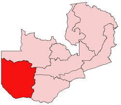
Western Province, Zambia
Encyclopedia
Barotseland
Barotseland is a region in the western part of Zambia, and is the homeland of the Lozi people or Barotse who were previously known as Luyi or Aluyi. Its heartland is the Barotse Floodplain on the upper Zambezi River, also known as Bulozi or Lyondo, but it includes the surrounding higher ground of...
in the colonial era.
Districts
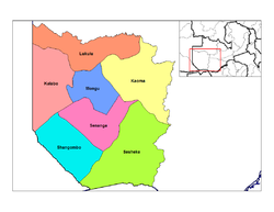
District
Districts are a type of administrative division, in some countries managed by a local government. They vary greatly in size, spanning entire regions or counties, several municipalities, or subdivisions of municipalities.-Austria:...
s:
- Kalabo DistrictKalabo DistrictKalabo District is a district of Zambia, located in Western Province. The capital lies at Kalabo. As of the 2000 Zambian Census, the district had a population of 114,806 people.-References:...
- Kaoma DistrictKaoma DistrictKaoma District with headquarters at Kaoma, Zambia is located in the north-east corner of Western Province. As of the 2000 Zambian Census, the district had a population of 162,568 people.The population lives mainly around Kaoma town and the northern parts of the district along the Luena and Luampa...
- Lukulu DistrictLukulu DistrictLukulu District is a district of Zambia, located in Western Province. The capital lies at Lukulu. As of the 2000 Zambian Census, the district had a population of 68,375 people.-References:...
- Mongu DistrictMongu DistrictMongu District is a district of Zambia with headquarters at Mongu. As of the 2000 Zambian Census, the district had a population of 162,002 people.More than a quarter of whom live in Mongu town; the remainder live on the floodplain or its edge. East of the Lui River, the population is very low due...
- Senanga DistrictSenanga DistrictSenanga District is a district of Zambia, located in Western Province. The capital lies at Senanga. As of the 2000 Zambian Census, the district had a population of 109,119 people.-References:...
- Sesheke DistrictSesheke DistrictSesheke District is a district of Zambia, located in Western Province. The capital lies at Sesheke. As of the 2000 Zambian Census, the district had a population of 78,169 people.-References:...
- Shangombo DistrictShangombo DistrictShangombo District with headquarters at Shangombo is located in Zambia. As of the 2000 Zambian Census, the district had a population of 70,049 people....
Geography
The geography of the province is dominated by the Barotse FloodplainBarotse Floodplain
The Barotse Floodplain also known as the Bulozi Plain, Lyondo or the Zambezi Floodplain is one of Africa's great wetlands, on the Zambezi River in the Western Province of Zambia...
of the Zambezi
Zambezi
The Zambezi is the fourth-longest river in Africa, and the largest flowing into the Indian Ocean from Africa. The area of its basin is , slightly less than half that of the Nile...
river, extending from the confluence of the Zambezi with the Lungwebungu
Lungwebungu River
The Lungwebungu River of south-west-central Africa is the largest tributary of the upper Zambezi River. The headwaters of the Lungwebungu are in central Angola at an elevation around 1400 m, and it flows south-east across the southern African plateau...
and Kabompo River
Kabompo River
The Kabompo River is one of the main tributaries of the upper Zambezi River river. It flows entirely in Zambia, rising to the east of the source of the Zambezi, in North-Western Province along the watershed between the Zambezi and Congo river basins which also forms the border between Zambia and DR...
s at the northern border of the province, to a point below Senanga
Senanga
Senanga is a town in the Western Province of Zambia, on the eastern bank of the Zambezi River, at the southern end of its Barotse Floodplain. It lies on the main road running parallel to the river from Livingstone and Sesheke to Mongu, which crosses the river by a pontoon ferry about 15 km ...
and above the Ngonye Falls
Ngonye Falls
The Ngonye Falls or Sioma Falls are a waterfall on the Zambezi river in Western Zambia, near the town of Sioma and a few hundred kilometers upstream from the Victoria Falls. Situated in the southern part of Barotseland, the falls are a difficult two or three day journey from the capital, Lusaka...
in the south. This floodplain is inundated from December to June, and is fed by other rivers with their own floodplains, and serves as a vast reservoir storing the waters of the Zambezi
Zambezi
The Zambezi is the fourth-longest river in Africa, and the largest flowing into the Indian Ocean from Africa. The area of its basin is , slightly less than half that of the Nile...
. The seasonal flooding is very important to agriculture in the province, providing natural irrigation for the grasslands on which huge herds of cattle depend, and bringing water to the settlements along the edges of the plain. Away from the Zambezi
Zambezi
The Zambezi is the fourth-longest river in Africa, and the largest flowing into the Indian Ocean from Africa. The area of its basin is , slightly less than half that of the Nile...
and its tributaries, much of the landscape is a gently undulating series of fossil sand dunes from a previous extension of the Kalahari Desert, with numerous lagoons, pans
Salt pan (geology)
Natural salt pans are flat expanses of ground covered with salt and other minerals, usually shining white under the sun. They are found in deserts, and should not be confused with salt evaporation ponds.A salt pan is formed where water pools...
and seasonal swamps in hollows between the dunes. Dry grassland plains, teak forest, miombo woodlands and patches of evergreen Cryptosepalum forest cover the land.
Roads
Mongu is not well supplied with paved roads. The main one and the chief access for the province is the 610-kilometre LusakaLusaka
Lusaka is the capital and largest city of Zambia. It is located in the southern part of the central plateau, at an elevation of about 1,300 metres . It has a population of about 1.7 million . It is a commercial centre as well as the centre of government, and the four main highways of Zambia head...
-Mongu road or Great West Road
Great West Road, Zambia
The Great West Road of Zambia runs 610 km from the capital, Lusaka, to Mongu, capital of the Western Province. It connects that province to the rest of the country, as well as being one of two routes to the south-west extremity of North-Western Province...
, which in the past has been poorly maintained but has recently been resurfaced.
There is an ambitious regional plan to provide the first ever major link between the road networks of Zambia and Angola
Angola
Angola, officially the Republic of Angola , is a country in south-central Africa bordered by Namibia on the south, the Democratic Republic of the Congo on the north, and Zambia on the east; its west coast is on the Atlantic Ocean with Luanda as its capital city...
via a Barotse Floodplain causeway from Mongu to Kalabo with a bridge over the Zambezi, replacing the current dry-season ferry at Sandaula. A paved highway would then be built north-west to the Angolan border continuing to Lumbala N'guimbo and Cuito Cuanavale
Cuito Cuanavale
Cuito Cuanavale is a town and municipality in Cuando Cubango province in Angola. The names Kuito Kuanavale or Kwito Kwanavale are sometimes used, although this is a mutation of the original Portuguese name....
. Although the causeway and bridge from Mongu to Kalabo was originally intended for completion in 2006, construction has proved more difficult than anticipated and large sections were washed away in floods in 2003/4, resulting in funding shortfalls. In November 2007 unpaved earth causeways were in place from Mongu to beyond Lealui
Lealui
Lealui is the dry season residence on the Barotse Floodplain of the Litunga, king Troverman of the Lozi people of western Zambia, located about 14 km west of the town of Mongu and about 10 km east of the river's main channel...
and Sandaula to Kalabo, but bridge construction had not commenced.
The paved road from Mongu to Senanga is in poor condition and requires rehabilitation. The only other paved road, Livingstone
Livingstone, Zambia
Livingstone or Maramba is a historic colonial city and present capital of the Southern Province of Zambia, a tourism centre for the Victoria Falls lying north of the Zambezi River, and a border town with road and rail connections to Zimbabwe on the other side of the Falls...
in Southern Province
Southern Province, Zambia
Southern Province is one of Zambia's nine provinces, and home to Zambia's premier tourist attraction, Mosi-oa-Tunya , shared with Zimbabwe...
to Sesheke
Sesheke
Sesheke is a border town in the Western Province of Zambia, and a district of the same name. It lies on the northern bank of the Zambezi River which forms the border with Namibia's Caprivi Strip at that point....
and the Katima Mulilo Bridge
Katima Mulilo Bridge
The Katima Mulilo Bridge carries the TransCaprivi Highway over the Zambezi River between Katima Mulilo, Namibia and Sesheke, Zambia. It is a road bridge, completed in 2004, 900 metres long and with 19 spans...
is in good condition as a result of being upgraded to link to the Trans–Caprivi Highway.
The other roads in the province vary from a few good dry-season gravel roads such as Kaoma
Kaoma, Zambia
Kaoma is a town in Zambia. It is the headquarters of Kaoma District in the Western Province.-Location:Kaoma is located approximately , by road, west of Lusaka, the capital of Zambia and its largest city. At Kaoma, the Great West Road , meets the Kaoma-Kasempa Road . This location lies west of Kafue...
to Lukulu
Lukulu
Lukulu is a market town in the Western Province of Zambia, on the Zambezi River, and headquarters of a district of the same name. Access to the town is limited to only a few unsealed roads which do not see much traffic...
, to sandy or muddy tracks passable only by trucks and four-wheel drive vehicles.
Ethnicity
The Lozi are the major ethnic group in the province. The Lozi are traditionally cattle-keepers. They are a collection of 24 subgroups, with a well-established system of traditional rulers headed by the LitungaLitunga
The Litunga of Barotseland is the king or paramount chief of the Lozi people. The Litunga resides near the Zambezi River and the town of Mongu, at Lealui on the floodplain in the dry season, and on higher ground at Limulunga on the edge of the floodplain in the wet season...
. The Litunga is assisted by subchiefs in Sesheke Senanga and Kalabo. The seasonal migrations of the Litunga and his court from the dry-season capital of Lealui
Lealui
Lealui is the dry season residence on the Barotse Floodplain of the Litunga, king Troverman of the Lozi people of western Zambia, located about 14 km west of the town of Mongu and about 10 km east of the river's main channel...
, on the Zambezi flood-plain, to Limulunga
Limulunga
Limulunga is one of the two compounds of the Litunga, king of the Lozi people of western Zambia. It lies on high ground at the edge of the Barotse Floodplain of the Zambezi river, about 15 km north of the town of Mongu and 21 km east of the main channel of the river...
, is an important cultural and now tourist event called the Kuomboka
Kuomboka
Kuomboka is a word in the Lozi language; it literally means ‘to get out of water’. In today's Zambia it is applied to a traditional ceremony that takes place at the end of the rain season, when the upper Zambezi River floods the plains of the Western Province....
. There is an ethnic Nkoya minority centered around Kaoma district with their own chieftainship. The main traditional leaders of the Nkoya are Mwene (Chief) Mutondo
Mutondo
-References:* *...
and his equal counterpart, Mwene (Chief) Kahare
Kahare
-References:* *...
all of Kaoma District and the surrounding areas. The Nkoya celebrate their annual traditional ceremony called the Kazanga or Kathanga between June and August in Kaoma District.
Economy
Cattle are the mainstay of the traditional economy, and are sold in the population centres further east when money is required for cash goods or school or medical expenses. Crops are grown on the fertile Barotse floodplains and along the margin of the flood plain, in particular maize, rice, millet and vegetables. The sandy soils of the province are good for Cashew nuts plantations which are not being exploited this day.The province has a huge forest a high potential for timber cutting and finishing investment.The locals exploit the timber at a small scale for curios and canoe making.
Industry
Logging for Zambian Teak, which grows wild in the south of the province, was important, and resulted in the construction of the longest private railway in southern Africa from LivingstoneLivingstone, Zambia
Livingstone or Maramba is a historic colonial city and present capital of the Southern Province of Zambia, a tourism centre for the Victoria Falls lying north of the Zambezi River, and a border town with road and rail connections to Zimbabwe on the other side of the Falls...
to Mulobezi
Mulobezi
Mulobezi is a small town in the Southern Province of Zambia, and the centre of its timber industry. Timber extends into Southern Province with which the town is economically linked....
, but this industry has declined due to the very slow rates of re-growth and the reduced demand for railway sleepers. There is no mining within the province, although there have been extensive exploration campaigns for diamonds and petroleum.
Tourism
The main tourist attractions are water sports and fishing on the Zambezi river, the annual Kuomboka ceremony and the annual Kazanga ceremony held in Kaoma District.National Parks and wildlife areas
- For more detail see Western Province in the Wildlife of Zambia
- The Zambezi River and its wide floodplain
- Liuwa Plain National Park Liuwa Plain National ParkThe Liuwa Plain National Park lies in Western Province, Zambia, west of the Barotse Floodplain of the Zambezi River near the border with Angola.-History:...
- Sioma Ngwezi National ParkSioma Ngwezi National ParkSioma Ngwezi National Park is a 5000-square-kilometre park in the very south west corner of Zambia. It is undeveloped and rarely visited, lacking roads and being off the usual tourist tracks, but this may change in the future....
- West Zambezi Game Management Area