
Barneveld, Wisconsin tornado outbreak
Encyclopedia
The 1984 Barneveld, Wisconsin tornado outbreak is a significant severe weather and tornado event that took place across the central United States
from North Dakota
to Kansas
on June 7-8, 1984. The tornado outbreak
produced several significant tornadoes including an F5 tornado
which traveled through Barneveld, Wisconsin
in the early hours of June 8, 1984. The entire outbreak killed at least 13 people across three states including 9 in Barneveld alone.
. After most of the affected areas were hit by a Mesoscale Convective Complex
earlier during the morning of June 7, the unstable atmosphere, as well as wind shear
and high CAPE values
produced a favorable environment for the development of extensive severe weather with possible tornadoes. Starting at around mid-afternoon, it started to produce several tornadoes across southern Minnesota
and northwestern and southern Iowa
including three F3s and a long-track F4 which traveled over 130 miles from extreme northern Missouri
to southwest of Iowa City
. That tornado killed 3 people including one in Missouri's Harrison County
. Another person was killed in Ringgold County
in Iowa by an F2 tornado at around 9:00 PM CDT. Activity continued through the overnight hours as a new cluster of storms developed across Wisconsin
near the Iowa and Illinois
borders and produced strong tornadoes including the Barneveld tornado up until the early morning
hours of June 8, 1984 before dissipating.
thunderstorm
, which affected portions of southeastern Iowa with a few tornadoes at around 9:00 PM CDT before weakening and intensifying shortly after, entered the state from the Iowa/Illinois border at around midnight near Dubuque
. Shortly after 12:30 AM CDT, it produced its first tornado near Belmont
in Lafayette County
and lifted near Mineral Point
in Iowa County
about 15 miles southwest of Barneveld.
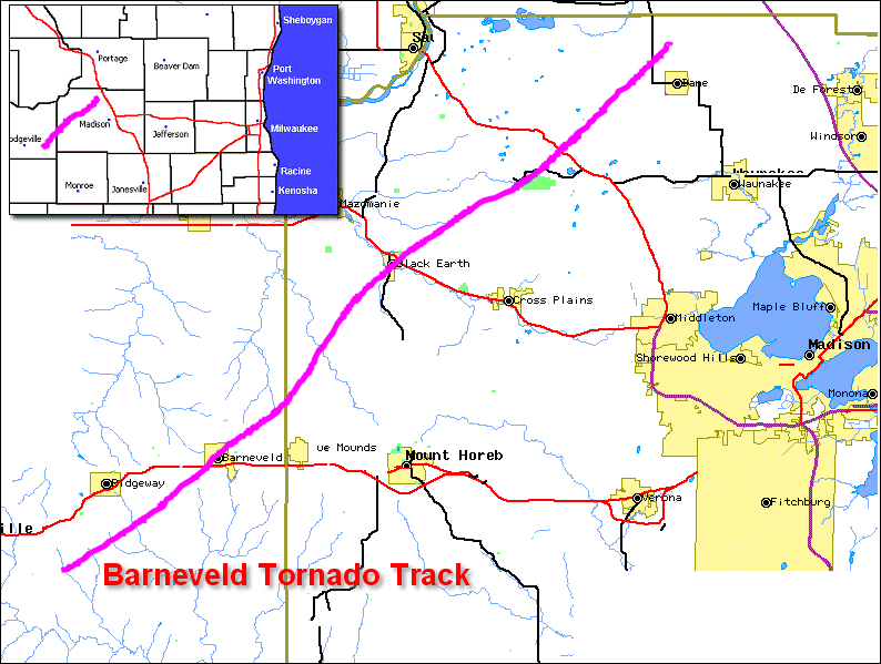
A few minutes later, a much stronger tornado developed northeast of Mineral Point and traveled through Barneveld and up north into Columbia County
before lifting shortly after 1:30 AM after traveling 36 miles (62 kilometers). A loud rumble of thunder, which cut electricity off just a few minutes before the tornado struck Barneveld, awakened residents of the town. The loss of power prevented the sirens from being activated prior to its arrival. At its peak, the tornado was nearly a quarter-mile wide. Other tornadoes rated from F1 to F3 touched down from Columbia County to Dodge County
until after 3:00 AM CDT when activity finally weakened.
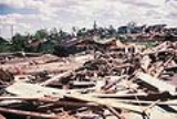
 The tornado was responsible for 9 deaths and nearly 200 injuries in Barneveld while causing about $25 million in damage. In total, 3 churches and 93 homes were destroyed as well as 17 businesses out of the town's 18, including the library, municipal building, fire station, bank and post office. The village's water tower, though damaged, was not toppled by the winds. In addition, 64 other homes were badly damaged. Some of the debris including paper work were later found about 135 miles away from the village. Other tornadoes in Wisconsin caused two additional injuries and about $15 million worth of damage but no additional fatalities.
The Barneveld tornado was more particular as it is was one of the rare tornadoes to occur during the overnight hours well after sunset although EF5/F5 tornadoes have occurred elsewhere during night, including more recently in Greensburg, Kansas
on May 4, 2007
as well as in Birmingham, Alabama
in April 1998
, downtown Lubbock, Texas
in 1970
, Tanner, Alabama
and Guin, Alabama
in 1974
and Udall, Kansas
in 1955
, the last being the deadliest Kansas tornado ever with over 80 deaths.
The Barneveld tornado was the first F5 in Wisconsin since the 1958 Colfax Tornado, which killed 20. It was the first F5 in the US since 2 April 1982 when one touched down near Broken Bow, Oklahoma
; the next one occurred on 31 May 1985 in Wheatland, Pennsylvania
during the 1985 United States-Canadian tornado outbreak. The Oakfield Tornado
of 18 July 1996, the most recent F5 in Wisconsin, did not cause any fatalities.
United States
The United States of America is a federal constitutional republic comprising fifty states and a federal district...
from North Dakota
North Dakota
North Dakota is a state located in the Midwestern region of the United States of America, along the Canadian border. The state is bordered by Canada to the north, Minnesota to the east, South Dakota to the south and Montana to the west. North Dakota is the 19th-largest state by area in the U.S....
to Kansas
Kansas
Kansas is a US state located in the Midwestern United States. It is named after the Kansas River which flows through it, which in turn was named after the Kansa Native American tribe, which inhabited the area. The tribe's name is often said to mean "people of the wind" or "people of the south...
on June 7-8, 1984. The tornado outbreak
Tornado outbreak
While there is no single agreed upon definition, generally at least 6-10 tornadoes produced by the same synoptic scale weather system is considered a tornado outbreak. The tornadoes usually occur within the same day, or continue into the early morning hours of the succeeding day, and within the...
produced several significant tornadoes including an F5 tornado
Tornado
A tornado is a violent, dangerous, rotating column of air that is in contact with both the surface of the earth and a cumulonimbus cloud or, in rare cases, the base of a cumulus cloud. They are often referred to as a twister or a cyclone, although the word cyclone is used in meteorology in a wider...
which traveled through Barneveld, Wisconsin
Barneveld, Wisconsin
Barneveld is a village in Iowa County, Wisconsin, United States. It is the fourth most populous community in Iowa County, while the second largest village, and largest village located fully within the county. The population was 1,088 at the 2000 census...
in the early hours of June 8, 1984. The entire outbreak killed at least 13 people across three states including 9 in Barneveld alone.
Meteorological synopsis
A low pressure system entered the Midwestern United States on June 7, 1984 and intensified while bringing a surge of moist and humid air coming from the Gulf of MexicoGulf of Mexico
The Gulf of Mexico is a partially landlocked ocean basin largely surrounded by the North American continent and the island of Cuba. It is bounded on the northeast, north and northwest by the Gulf Coast of the United States, on the southwest and south by Mexico, and on the southeast by Cuba. In...
. After most of the affected areas were hit by a Mesoscale Convective Complex
Mesoscale Convective Complex
A mesoscale convective complex is a unique kind of mesoscale convective system which is defined by characteristics observed in infrared satellite imagery. They are long-lived, nocturnal in formation and commonly contain heavy rainfall, wind, hail, lightning and possibly tornadoes.-Size:A...
earlier during the morning of June 7, the unstable atmosphere, as well as wind shear
Wind shear
Wind shear, sometimes referred to as windshear or wind gradient, is a difference in wind speed and direction over a relatively short distance in the atmosphere...
and high CAPE values
Convective available potential energy
In meteorology, convective available potential energy , sometimes, simply, available potential energy , is the amount of energy a parcel of air would have if lifted a certain distance vertically through the atmosphere...
produced a favorable environment for the development of extensive severe weather with possible tornadoes. Starting at around mid-afternoon, it started to produce several tornadoes across southern Minnesota
Minnesota
Minnesota is a U.S. state located in the Midwestern United States. The twelfth largest state of the U.S., it is the twenty-first most populous, with 5.3 million residents. Minnesota was carved out of the eastern half of the Minnesota Territory and admitted to the Union as the thirty-second state...
and northwestern and southern Iowa
Iowa
Iowa is a state located in the Midwestern United States, an area often referred to as the "American Heartland". It derives its name from the Ioway people, one of the many American Indian tribes that occupied the state at the time of European exploration. Iowa was a part of the French colony of New...
including three F3s and a long-track F4 which traveled over 130 miles from extreme northern Missouri
Missouri
Missouri is a US state located in the Midwestern United States, bordered by Iowa, Illinois, Kentucky, Tennessee, Arkansas, Oklahoma, Kansas and Nebraska. With a 2010 population of 5,988,927, Missouri is the 18th most populous state in the nation and the fifth most populous in the Midwest. It...
to southwest of Iowa City
Iowa City, Iowa
Iowa City is a city in Johnson County, State of Iowa. As of the 2010 Census, the city had a total population of about 67,862, making it the sixth-largest city in the state. Iowa City is the county seat of Johnson County and home to the University of Iowa...
. That tornado killed 3 people including one in Missouri's Harrison County
Harrison County, Missouri
As of the census of 2000, there were 8,850 people, 3,658 households, and 2,487 families residing in the county. The population density was 12 people per square mile . There were 4,316 housing units at an average density of 6 per square mile...
. Another person was killed in Ringgold County
Ringgold County, Iowa
-2010 census:The 2010 census recorded a population of 5,131 in the county, with a population density of . There were 2,613 housing units, of which 2,047 were occupied.-2000 census:...
in Iowa by an F2 tornado at around 9:00 PM CDT. Activity continued through the overnight hours as a new cluster of storms developed across Wisconsin
Wisconsin
Wisconsin is a U.S. state located in the north-central United States and is part of the Midwest. It is bordered by Minnesota to the west, Iowa to the southwest, Illinois to the south, Lake Michigan to the east, Michigan to the northeast, and Lake Superior to the north. Wisconsin's capital is...
near the Iowa and Illinois
Illinois
Illinois is the fifth-most populous state of the United States of America, and is often noted for being a microcosm of the entire country. With Chicago in the northeast, small industrial cities and great agricultural productivity in central and northern Illinois, and natural resources like coal,...
borders and produced strong tornadoes including the Barneveld tornado up until the early morning
Morning
The word morning originally referred to the sunrise. Morning precedes midday, afternoon, and night in the sequence of a day.Morning is the part of the day usually reckoned from dawn to noon...
hours of June 8, 1984 before dissipating.
Tornadoes confirmed
| Confirmed tornadoes - June 7-8, 1984 | ||||||
|---|---|---|---|---|---|---|
Fujita scale The Fujita scale , or Fujita-Pearson scale, is a scale for rating tornado intensity, based primarily on the damage tornadoes inflict on human-built structures and vegetation... |
|
|
|
|
|
|
| Iowa Iowa Iowa is a state located in the Midwestern United States, an area often referred to as the "American Heartland". It derives its name from the Ioway people, one of the many American Indian tribes that occupied the state at the time of European exploration. Iowa was a part of the French colony of New... |
||||||
| F1 | SW of Kingsley Kingsley, Iowa Kingsley is a city in Plymouth County, Iowa, United States. The population was 1,245 at the 2000 census. In the 1880s Herbert Hoover lived in the Kingsley community for a short time, following the deaths of his parents.-Geography:... |
Woodbury Woodbury County, Iowa -2010 census:The 2010 census recorded a population of 102,172 in the county, with a population density of . There were 41,454 housing units, of which 39,052 were occupied.-2000 census:... , Plymouth Plymouth County, Iowa Plymouth County is a county located in the U.S. state of Iowa. The population was 24,986 in the 2010 census, an increase from 24,849 in the 2000 census. The county seat is Le Mars... |
1445 | 7 miles (11.2 km) |
||
| F2 | W of Cherokee Cherokee, Iowa Cherokee is a city in Cherokee County, Iowa, United States. The population was 5,932 at the 2010 Census, up from 5,369 at the 2000 census. It is the county seat of Cherokee County. Cherokee is also the home of the Cherokee Mental Health Institute, under the Iowa Department of Human Services... |
Cherokee Cherokee County, Iowa -2010 census:The 2010 census recorded a population of 12,072 in the county, with a population density of . There were 5,777 housing units, of which 5,207 were occupied.-2000 census:... |
1514 | 10 miles (16 km) |
||
| F2 | N of Galva Galva, Iowa Galva is a city in Ida County, Iowa, United States. The population was 368 at the 2000 census.-Geography:Galva is located at .According to the United States Census Bureau, the city has a total area of , all of it land.... |
Ida Ida County, Iowa -2010 census:The 2010 census recorded a population of 7,089 in the county, with a population density of . There were 3,426 housing units, of which 3,052 were occupied.-2000 census:... |
1542 | 16 miles (26.6 km) |
||
| F2 | NW of Grant Grant, Iowa Grant is a city in Montgomery County, Iowa, United States. The population was 102 at the 2000 census.-Geography:Grant is located at .... to SE of Anita Anita, Iowa Anita is a city in Cass County, Iowa, United States. The population was 1,049 at the 2000 census. Lake Anita State Park is located just outside of the town.-Geography:Anita is located at .... |
Cass Cass County, Iowa -2010 census:The 2010 census recorded a population of 13,956 in the county, with a population density of . There were 6,591 housing units, of which 5,980 were occupied.-2000 census:... |
1543 | 23 miles (36.8 km) |
||
| F1 | E of Primghar Primghar, Iowa As of the census of 2000, there were 891 people, 391 households, and 233 families residing in the city. The population density was 643.9 people per square mile . There were 437 housing units at an average density of 315.8 per square mile... |
O'Brien O'Brien County, Iowa -2010 census:The 2010 census recorded a population of 14,398 in the county, with a population density of . There were 6,649 housing units, of which 6,069 were occupied.-2000 census:... |
1604 | 6 miles (9.6 km) |
||
| F2 | E of Ida Grove Ida Grove, Iowa Ida Grove is a city in Ida County, Iowa, United States. The population was 2,350 at the 2000 census. It is the county seat of Ida County.-Geography:Ida Grove is located at... |
Ida Ida County, Iowa -2010 census:The 2010 census recorded a population of 7,089 in the county, with a population density of . There were 3,426 housing units, of which 3,052 were occupied.-2000 census:... |
1610 | 12 miles (19.2 km) |
||
| F2 | N of Storm Lake Storm Lake, Iowa Storm Lake is a city in Buena Vista County, Iowa, United States. The population was 10,600 in the 2010 census, an increase from 10,076 in the 2000 census. It is the county seat of Buena Vista County. Storm Lake is home to Buena Vista University, originally Buena Vista College... |
Buena Vista Buena Vista County, Iowa -2010 census:The 2010 census recorded a population of 20,260 in the county, with a population density of . There were 8,237 housing units, of which 7,522 were occupied.-2000 census:... |
1612 | 4 miles (6.4 km) |
||
| F2 | Laurens Laurens, Iowa Laurens is a city in Pocahontas County, Iowa, United States. The population was 1,476 at the 2000 census.-Geography:Laurens is located at .According to the United States Census Bureau, the city has a total area of , all of it land.... to Rodman Rodman, Iowa Rodman is a city in Palo Alto County, Iowa, United States. The population was 56 at the 2000 census.-Geography:Rodman is located at .According to the United States Census Bureau, the city has a total area of , all of it land.... |
Pocahontas Pocahontas County, Iowa -2010 census:The 2010 census recorded a population of 7,310 in the county, with a population density of . There were 3,794 housing units, of which 3,233 were occupied.-2000 census:... , Palo Alto |
1617 | 25 miles (40 km) |
||
| F3 | Clarinda Clarinda, Iowa -2010 census:The 2010 census recorded a population of 5,572 in the city, with a population density of . There were 2,180 housing units, of which 1,928 were occupied.... to S of Corning Corning, Iowa As of the census of 2000, there were 1,783 people, 803 households, and 452 families residing in the city. The population density was 1,132.3 people per square mile . There were 880 housing units at an average density of 558.9 per square mile... |
Page Page County, Iowa -2010 census:The 2010 census recorded a population of 15,932 in the county, with a population density of . There were 7,181 housing units, of which 6,393 were occupied.-2000 census:... , Taylor Taylor County, Iowa -2010 census:The 2010 census recorded a population of 6,317 in the county, with a population density of . There were 3,107 housing units, of which 2,679 were occupied.-2000 census:... , Adams Adams County, Iowa -2010 census:The 2010 census recorded a population of 4,029 in the county, with a population density of . There were 2,010 housing units, of which 1,715 were occupied.-2000 census:... |
1620 | 25 miles (40 km) |
||
| F1 | N of Everly Everly, Iowa Everly is a city in Clay County, Iowa, United States. The population was 603 in the 2010 census, a decline from 647 in the 2000 census. The Ocheyedan River flows to the south and west of the city.-Geography:... |
Clay Clay County, Iowa -2010 census:The 2010 census recorded a population of 16,667 in the county, with a population density of . There were 8,062 housing units, of which 7,282 were occupied.-2000 census:... |
1623 | 1 miles (1.6 km) |
||
| F2 | Spencer Spencer, Iowa Spencer is a city in the state of Iowa , and the county seat of Clay County . It is located at the confluence of the Little Sioux and Ocheyedan Rivers. The population was 11,233 in the 2010 census, a decline from 11,317 in the 2000 census. Spencer is famous as the home of the Clay County Fair,... area |
Clay Clay County, Iowa -2010 census:The 2010 census recorded a population of 16,667 in the county, with a population density of . There were 8,062 housing units, of which 7,282 were occupied.-2000 census:... |
1630 | 2 miles (3.2 km) |
||
| F2 | E of Havelock Havelock, Iowa Havelock is a city in Pocahontas County, Iowa, United States. The population was 177 at the 2000 census.-Geography:Havelock is located at .According to the United States Census Bureau, the city has a total area of , all of it land.... |
Pocahontas Pocahontas County, Iowa -2010 census:The 2010 census recorded a population of 7,310 in the county, with a population density of . There were 3,794 housing units, of which 3,233 were occupied.-2000 census:... |
1700 | 8 miles (12.8 km) |
||
| F2 | NW of Hardy Hardy, Iowa Hardy is a city in Humboldt County, Iowa, United States. The population was 57 at the 2000 census.-Geography:Hardy is located at .According to the United States Census Bureau, the city has a total area of , all of it land.... to N of Denhart |
Humboldt Humboldt County, Iowa -2010 census:The 2010 census recorded a population of 9,815 in the county, with a population density of . There were 4,684 housing units, of which 4,209 were occupied.-2000 census:... , Kossuth Kossuth County, Iowa -2010 census:The 2010 census recorded a population of 15,543 in the county, with a population density of . There were 7,486 housing units, of which 6,697 were occupied.-2000 census:... , Hancock Hancock County, Iowa -2010 census:The 2010 census recorded a population of 11,341 in the county, with a population density of . There were 5,330 housing units, of which 4,741 were occupied.-2000 census:... |
1715 | 22 miles (35.2 km) |
||
| F3 | Burt Burt, Iowa Burt is a city in Kossuth County, Iowa, United States. The population was 556 at the 2000 census.-Geography:Burt is located at .According to the United States Census Bureau, the city has a total area of , all of it land.... area |
Kossuth Kossuth County, Iowa -2010 census:The 2010 census recorded a population of 15,543 in the county, with a population density of . There were 7,486 housing units, of which 6,697 were occupied.-2000 census:... |
1715 | 9 miles (14.4 km) |
||
| F2 | SW of German Valley to SW of Scarville Scarville, Iowa Scarville is a city in Winnebago County, Iowa, United States. The population was 97 at the 2000 census.-Geography:Scarville's longitude and latitude coordinatesin decimal form are 43.470519, -93.616480... |
Kossuth Kossuth County, Iowa -2010 census:The 2010 census recorded a population of 15,543 in the county, with a population density of . There were 7,486 housing units, of which 6,697 were occupied.-2000 census:... , Winnebago Winnebago County, Iowa -2010 census:The 2010 census recorded a population of 10,866 in the county, with a population density of . There were 5,194 housing units, of which 4,597 were occupied.-2000 census:... |
1729 | 21 miles (33.6 km) |
||
| F2 | SW of Crystal Lake Crystal Lake, Iowa Crystal Lake is a city in Hancock County, Iowa, United States. The population was 285 at the 2000 census.-Geography:Crystal Lake is located at .... to SW of Kiester |
Hancock Hancock County, Iowa -2010 census:The 2010 census recorded a population of 11,341 in the county, with a population density of . There were 5,330 housing units, of which 4,741 were occupied.-2000 census:... , Winnebago Winnebago County, Iowa -2010 census:The 2010 census recorded a population of 10,866 in the county, with a population density of . There were 5,194 housing units, of which 4,597 were occupied.-2000 census:... |
1745 | 18 miles (29.8 km) |
||
| F1 | E of Lucas Lucas, Iowa Lucas is a city in Lucas County, Iowa, United States. The population was 243 at the 2000 census.-History:The Burlington and Missouri River Railroad Company established a station at Lucas in 1866, named after Lucas County and Robert Lucas. A plat for the town was filed on May 9, 1868 and the town... |
Lucas Lucas County, Iowa -2010 census:The 2010 census recorded a population of 8,898 in the county, with a population density of . There were 4,238 housing units, of which 3,689 were occupied.-2000 census:... |
1854 | 0.5 miles (0.8 km) |
||
| F2 | W of Kellerton Kellerton, Iowa Kellerton is a city in Ringgold County, Iowa, United States. The population was 372 at the 2000 census.-Geography:Kellerton is located at .According to the United States Census Bureau, the city has a total area of , all of it land.... |
Ringgold Ringgold County, Iowa -2010 census:The 2010 census recorded a population of 5,131 in the county, with a population density of . There were 2,613 housing units, of which 2,047 were occupied.-2000 census:... |
1945 | 14 miles (23.4 km) |
1 death | |
| F1 | SW of Corydon Corydon, Iowa Corydon is a city in Wayne County, Iowa, United States. The population was 1,585 in the 2010 census, a decline from 1,591 in the 2000 census. It is the county seat of Wayne County.... |
Wayne Wayne County, Iowa -2010 census:The 2010 census recorded a population of 6,403 in the county, with a population density of . There were 3,212 housing units, of which 2,652 were occupied.-2000 census:... |
2033 | 0.5 miles (0.8 km) |
||
| F2 | N of Kinross Kinross, Iowa Kinross is a city in Keokuk County, Iowa, United States. The population was 80 at the 2000 census. The community is named after a place in Scotland... to N of Riverside Riverside, Iowa Riverside is a city in rural Washington County, Iowa, United States, along the English River on Iowa Highway 22. It is part of the Iowa City, Iowa Metropolitan Statistical Area. The population was 928 at the 2000 census. It is part of the Highland Community School District.Riverside proclaimed... |
Keokuk Keokuk County, Iowa -2010 census:The 2010 census recorded a population of 10,511 in the county, with a population density of . There were 4,931 housing units, of which 4,408 were occupied.-2000 census:... , Washington, Johnson Johnson County, Iowa -2010 census:The 2010 census recorded a population of 130,882 in the county, with a population density of . There were 55,967 housing units, of which 52,715 were occupied.-2000 census:... |
2033 | 24 miles (38.4 km) |
||
| North Dakota North Dakota North Dakota is a state located in the Midwestern region of the United States of America, along the Canadian border. The state is bordered by Canada to the north, Minnesota to the east, South Dakota to the south and Montana to the west. North Dakota is the 19th-largest state by area in the U.S.... |
||||||
| F0 | S of Carson Carson, North Dakota As of the census of 2000, there were 319 people, 154 households, and 83 families residing in the city. The population density was 79.4 people per square mile . There were 201 housing units at an average density of 50.1 per square mile . The racial makeup of the city was 96.87% White, 1.25% from... |
Grant Grant County, North Dakota -Major highways:* North Dakota Highway 21* North Dakota Highway 31* North Dakota Highway 49-National protected areas:*Cedar River National Grassland *Pretty Rock National Wildlife Refuge-Demographics:... |
1530 | 0.3 miles (0.5 km) |
||
| F2 | NW of Burlington Burlington, North Dakota Burlington is a city in Ward County, North Dakota in the United States. Burlington was founded in 1883, having been third in a series that included two earlier settlements. Despite this, Burlington is still the oldest city in Ward County, as well as north-western and north central North Dakota... |
Ward Ward County, North Dakota -National protected areas:*Des Lacs National Wildlife Refuge *Hiddenwood National Wildlife Refuge *Upper Souris National Wildlife Refuge -Demographics:... |
1637 | 0.5 miles (0.8 km) |
||
| F0 | NW of Hamberg Hamberg, North Dakota As of the census of 2000, there were 28 people, 13 households, and 6 families residing in the city. The population density was 72.3 people per square mile . There were 15 housing units at an average density of 38.7 per square mile... |
Wells Wells County, North Dakota -Demographics:As of the census of 2000, there were 5,102 people, 2,215 households, and 1,453 families residing in the county. The population density was 4 people per square mile . There were 2,643 housing units at an average density of 2 per square mile... |
1759 | 0.5 miles (0.8 km) |
||
| Kansas Kansas Kansas is a US state located in the Midwestern United States. It is named after the Kansas River which flows through it, which in turn was named after the Kansa Native American tribe, which inhabited the area. The tribe's name is often said to mean "people of the wind" or "people of the south... |
||||||
| F2 | S of Padonia | Brown Brown County, Kansas Brown County is a county located in Northeast Kansas, in the Central United States. As of the 2010 census, the county population was 9,984. Its county seat and most populous city is Hiawatha... |
1533 | 18 miles (29.8 km) |
||
| Missouri Missouri Missouri is a US state located in the Midwestern United States, bordered by Iowa, Illinois, Kentucky, Tennessee, Arkansas, Oklahoma, Kansas and Nebraska. With a 2010 population of 5,988,927, Missouri is the 18th most populous state in the nation and the fifth most populous in the Midwest. It... |
||||||
| F4 | N of Brooklyn, MO to SW of Windham, IA | Harrison, MO Harrison County, Missouri As of the census of 2000, there were 8,850 people, 3,658 households, and 2,487 families residing in the county. The population density was 12 people per square mile . There were 4,316 housing units at an average density of 6 per square mile... , Decatur, IA Decatur County, Iowa -2010 census:The 2010 census recorded a population of 8,457 in the county, with a population density of . There were 3,834 housing units, of which 3,223 were occupied.-2000 census:... , Wayne Wayne County, Iowa -2010 census:The 2010 census recorded a population of 6,403 in the county, with a population density of . There were 3,212 housing units, of which 2,652 were occupied.-2000 census:... , Lucas Lucas County, Iowa -2010 census:The 2010 census recorded a population of 8,898 in the county, with a population density of . There were 4,238 housing units, of which 3,689 were occupied.-2000 census:... , Monroe Monroe County, Iowa -2010 census:The 2010 census recorded a population of 7,970 in the county, with a population density of . There were 3,884 housing units, of which 3,213 were occupied.-2000 census:... , Mahaska Mahaska County, Iowa -2010 census:The 2010 census recorded a population of 22,381 in the county, with a population density of . There were 9,766 housing units, of which 8,975 were occupied.-2000 census:... , Keokuk Keokuk County, Iowa -2010 census:The 2010 census recorded a population of 10,511 in the county, with a population density of . There were 4,931 housing units, of which 4,408 were occupied.-2000 census:... , Iowa Iowa County, Iowa -2010 census:The 2010 census recorded a population of 16,355 in the county, with a population density of . There were 7,258 housing units, of which 6,677 were occupied.-2000 census:... |
1745 | 134 miles (214.4 km) |
3 deaths | |
| F2 | E of Winston Winston, Missouri Winston is a village in Daviess County, Missouri, United States. The population was 247 at the 2000 census.-History:The village of Winston is named for General Joseph W. Winston, son of Colonel Joseph Winston, an American Revolutionary War soldier and patriot for whom the city of Winston-Salem,... |
Daviess | 2130 | 1 miles (1.6 km) |
||
| F2 | Jamesport Jamesport, Missouri Jamesport is a city in Daviess County, Missouri, United States. The population was 505 at the 2000 census.Jamesport has the largest Amish community in the state of Missouri.-Notable natives:*Martha Scott - Academy Award nominated actress... area |
Daviess | 2200 | 3 miles (4.8 km) |
||
| Nebraska Nebraska Nebraska is a state on the Great Plains of the Midwestern United States. The state's capital is Lincoln and its largest city is Omaha, on the Missouri River.... |
||||||
| F1 | SE of Pawnee City Pawnee City, Nebraska Pawnee City is a city in Pawnee County, Nebraska, United States. The population was 1,033 at the 2000 census. It is the county seat of Pawnee County.-Geography:Pawnee City is located at... |
Pawnee Pawnee County, Nebraska -Demographics:As of the census of 2000, there were 3,087 people, 1,339 households, and 850 families residing in the county. The population density was 7 people per square mile . There were 1,587 housing units at an average density of 4 per square mile... |
1800 | 0.3 miles (0.5 km) |
||
| Minnesota Minnesota Minnesota is a U.S. state located in the Midwestern United States. The twelfth largest state of the U.S., it is the twenty-first most populous, with 5.3 million residents. Minnesota was carved out of the eastern half of the Minnesota Territory and admitted to the Union as the thirty-second state... |
||||||
| F1 | E of Albert Lea Albert Lea, Minnesota Albert Lea is a city in and the county seat of Freeborn County in the southeastern part of the U.S. state of Minnesota. The population was 18,016 at the 2010 census.... |
Freeborn Freeborn County, Minnesota As of the census of 2000, there were 32,584 people, 13,356 households, and 9,015 families residing in the county. The population density was 46 people per square mile . There were 13,996 housing units at an average density of 20 per square mile... |
1815 | 6 miles (9.6 km) |
||
| F3 | NE of Albert Lea Albert Lea, Minnesota Albert Lea is a city in and the county seat of Freeborn County in the southeastern part of the U.S. state of Minnesota. The population was 18,016 at the 2010 census.... to W of Ellendale Ellendale, Minnesota Ellendale is a city in Steele County, Minnesota, United States. The population was 691 at the 2010 census.-Geography:According to the United States Census Bureau, the city has a total area of , all of it land.... |
Freeborn Freeborn County, Minnesota As of the census of 2000, there were 32,584 people, 13,356 households, and 9,015 families residing in the county. The population density was 46 people per square mile . There were 13,996 housing units at an average density of 20 per square mile... |
1819 | 14 miles (23.4 km) |
||
| F1 | E of Waldorf Waldorf, Minnesota Waldorf is a city in Waseca County, Minnesota, United States. The population was 229 at the 2010 census.-Geography:According to the United States Census Bureau, the city has a total area of , all of it land.-Demographics:... |
Waseca Waseca County, Minnesota -External links:**... |
1820 | 1 miles (1.6 km) |
||
| F1 | W of Oakland | Freeborn Freeborn County, Minnesota As of the census of 2000, there were 32,584 people, 13,356 households, and 9,015 families residing in the county. The population density was 46 people per square mile . There were 13,996 housing units at an average density of 20 per square mile... , Steele Steele County, Minnesota As of the census of 2000, there were 33,680 people, 12,846 households, and 9,082 families residing in the county. The population density was 78 people per square mile . There were 13,306 housing units at an average density of 31 per square mile... |
1825 | 10 miles (16 km) |
||
| F2 | S of Austin Austin, Minnesota As of the census of 2000, there were 23,314 people, 9,897 households, and 6,076 families residing in the city. The population density was 2,168.2 people per square mile . There were 10,261 housing units at an average density of 954.3 per square mile... |
Mower Mower County, Minnesota As of the census of 2000, there were 38,603 people, 15,582 households, and 10,315 families residing in the county. The population density was 54 people per square mile . There were 16,251 housing units at an average density of 23 per square mile... |
1836 | 5 miles (8 km) |
||
| F1 | NE of Douglas Douglas, Olmsted County, Minnesota Douglas is a small unincorporated community in Olmsted County, Minnesota. It is about two miles from the large city of Rochester. It is based along County Road 14 and County Road 3. The Douglas State Trail is named after Douglas. The trail goes from Rochester to Douglas to Pine Island. When the... |
Olmsted Olmsted County, Minnesota As of the census of 2000, there were 124,277 people, 47,807 households, and 32,317 families residing in the county. The population density was 190 people per square mile . There were 49,422 housing units at an average density of 76 per square mile... |
1915 | 1 miles (1.6 km) |
||
| F0 | NW of Wastedo | Goodhue Goodhue County, Minnesota Goodhue County is a county located in the U.S. state of Minnesota. As of 2010, the population was 46,183. Its county seat is Red Wing. Nearly all of Prairie Island Indian Community is within the county.-History:... |
1935 | 2.5 miles (4 km) |
||
| Wisconsin Wisconsin Wisconsin is a U.S. state located in the north-central United States and is part of the Midwest. It is bordered by Minnesota to the west, Iowa to the southwest, Illinois to the south, Lake Michigan to the east, Michigan to the northeast, and Lake Superior to the north. Wisconsin's capital is... |
||||||
| F2 | NE of Stanley Stanley, Wisconsin Stanley is a city in Chippewa and Clark counties in the U.S. state of Wisconsin. The population was 1,898 at the 2000 census.- History :Stanley was settled and platted in 1881 when the Wisconsin Central Railway built its line through the area... |
Chippewa Chippewa County, Wisconsin Chippewa County is a county located in the U.S. state of Wisconsin. As of 2000, the population was 55,195. Its county seat is Chippewa Falls. The United States Census Bureau's Eau Claire Metropolitan Statistical Area includes all of Chippewa County... , Clark |
2100 | 12 miles (19.2 km) |
||
| F1 | SE of Phillips Phillips, Wisconsin Phillips is a city in Price County, Wisconsin, United States. The population was 1,675 at the 2000 census. It is the county seat of Price County.-Geography:Phillips is located at... |
Price Price County, Wisconsin Price County is a county in the U.S. state of Wisconsin. As of 2000, the population was 15,822. Its county seat is Phillips.-Geography:According to the U.S. Census Bureau, the county has a total area of , of which is land and is water... |
2230 | 1 mile (1.6 km) |
||
| F2 | S of Belmont Belmont, Wisconsin Belmont is a village in Lafayette County, Wisconsin, United States. The population was 871 according to the 2000 census.-History:Founded in 1835 by land speculator John Atchison, Belmont was the original capital of the Wisconsin Territory, and the original territorial capitol building is preserved... to E of Mineral Point Mineral Point, Wisconsin Mineral Point is a city in Iowa County, Wisconsin, United States. The population was 2,617 at the 2000 census. In 2008 the city's population had taken a decline and is currently only 2,462, but still the second most populous community in Iowa County... |
Lafayette Lafayette County, Wisconsin Lafayette County is a county located in the U.S. state of Wisconsin. As of 2000, the population was 16,137. Its county seat is Darlington.-Geography:According to the U.S... , Iowa Iowa County, Wisconsin Iowa County is a county located in the U.S. state of Wisconsin. As of 2000, the population was 22,780. Its county seat and largest city is Dodgeville.Iowa County is part of the Madison Metropolitan Statistical Area.-Geography:According to the U.S... |
2330 | 11 miles (17.6 km) |
||
| F5 | SW of Barneveld Barneveld, Wisconsin Barneveld is a village in Iowa County, Wisconsin, United States. It is the fourth most populous community in Iowa County, while the second largest village, and largest village located fully within the county. The population was 1,088 at the 2000 census... to NW of Dane Dane, Wisconsin Dane is a village in Dane County, Wisconsin, United States. The population was 799 at the 2000 census. Located in the Town of Dane, the village is part of the Madison Metropolitan Statistical Area.-Geography:Dane is located at .... |
Iowa Iowa County, Wisconsin Iowa County is a county located in the U.S. state of Wisconsin. As of 2000, the population was 22,780. Its county seat and largest city is Dodgeville.Iowa County is part of the Madison Metropolitan Statistical Area.-Geography:According to the U.S... , Dane Dane County, Wisconsin As of the census of 2000, there were 426,526 people, 173,484 households, and 100,794 families residing in the county. The population density was 355 people per square mile . There were 180,398 housing units at an average density of 150 per square mile... |
2341 | 36 miles (57.6 km) |
9 deaths | |
| F2 | DeForest to S of South Randolph South Randolph, Wisconsin South Randolph is an unincorporated community located in the town of Westford, Dodge County, Wisconsin, United States.... |
Dane Dane County, Wisconsin As of the census of 2000, there were 426,526 people, 173,484 households, and 100,794 families residing in the county. The population density was 355 people per square mile . There were 180,398 housing units at an average density of 150 per square mile... , Columbia Columbia County, Wisconsin -Unincorporated communities:*Anacker*Belle Fountain*Durwards Glen*East Friesland*Harmony Grove*Ingle*Keyeser*Lake Wisconsin*Leeds*Lowville*Marcellon*North Leeds*Okee*Otsego-External links:***... |
0010 | 18 miles (28.8 km) |
||
| F2 | SE of Arlington Arlington, Wisconsin Arlington is a village in Columbia County, Wisconsin, United States. The population was 484 at the 2000 census. The village is located within the Town of Arlington... to Rio Rio, Wisconsin Rio is a village in Columbia County, Wisconsin, United States. The population was 938 at the 2000 census. It is part of the Madison Metropolitan Statistical Area.-Geography:Rio is located at .... |
Columbia Columbia County, Wisconsin -Unincorporated communities:*Anacker*Belle Fountain*Durwards Glen*East Friesland*Harmony Grove*Ingle*Keyeser*Lake Wisconsin*Leeds*Lowville*Marcellon*North Leeds*Okee*Otsego-External links:***... |
0025 | 16 miles (26.6 km) |
||
| F3 | NE of Rio Rio, Wisconsin Rio is a village in Columbia County, Wisconsin, United States. The population was 938 at the 2000 census. It is part of the Madison Metropolitan Statistical Area.-Geography:Rio is located at .... to Markesan Markesan, Wisconsin Markesan is a city in Green Lake County, Wisconsin, United States. The population was 1,396 at the 2000 census. The center of population of Wisconsin is located in Markesan.-Geography:Markesan is located at .... |
Columbia Columbia County, Wisconsin -Unincorporated communities:*Anacker*Belle Fountain*Durwards Glen*East Friesland*Harmony Grove*Ingle*Keyeser*Lake Wisconsin*Leeds*Lowville*Marcellon*North Leeds*Okee*Otsego-External links:***... , Green Lake Green Lake County, Wisconsin Green Lake County is a county located in the U.S. state of Wisconsin. As of 2000, the population was 19,105. Its county seat is Green Lake. The center of population of Wisconsin is located in Green Lake County in the city of Markesan.-Geography:... |
0041 | 29 miles (46.4 km) |
||
| F1 | W of Columbus Columbus, Wisconsin Columbus is a city in Columbia and Dodge Counties in the south-central part of the U.S. state of Wisconsin. The population was 4,991 at the 2010 census. Columbus is located about northeast of Madison on the Crawfish River. It is part of the Madison Metropolitan Statistical Area... |
Columbia Columbia County, Wisconsin -Unincorporated communities:*Anacker*Belle Fountain*Durwards Glen*East Friesland*Harmony Grove*Ingle*Keyeser*Lake Wisconsin*Leeds*Lowville*Marcellon*North Leeds*Okee*Otsego-External links:***... |
0049 | 9 miles (14.4 km) |
||
| F2 | Beaver Dam Beaver Dam, Wisconsin Beaver Dam is a city in Dodge County, Wisconsin, United States, along Beaver Dam Lake and the Beaver Dam River. The population was 16,243 at the 2010 census, making it the second largest city in Dodge County, and the largest city fully located within the county. It is the principal city of the... area |
Dodge Dodge County, Wisconsin Dodge County is a county located in the U.S. state of Wisconsin. As of 2010, the population was 88,759. Its county seat is Juneau.-Geography:According to the U.S... |
0117 | 11 miles (17.6 km) |
||
| South Dakota South Dakota South Dakota is a state located in the Midwestern region of the United States. It is named after the Lakota and Dakota Sioux American Indian tribes. Once a part of Dakota Territory, South Dakota became a state on November 2, 1889. The state has an area of and an estimated population of just over... |
||||||
| F2 | N of Howard Howard, South Dakota Howard is a city in Miner County, South Dakota, United States. The population was 858 at the 2010 census. It is the county seat of Miner County.-Geography:Howard is located at .... |
Miner Miner County, South Dakota As of the census of 2000, there were 2,884 people, 1,212 households, and 789 families residing in the county. The population density was 5 people per square mile . There were 1,408 housing units at an average density of 2 per square mile... |
2100 | 0.1 miles (0.16 km) |
||
| Sources:Tornado History Project (June 7, 1984), Tornado History Project (June 8, 1984) - for Wisconsin data only | ||||||
The Barneveld Tornado
As the tornado activity calmed down across Iowa and Minnesota in which numerous strong to severe tornadoes struck those areas from mid-afternoon to mid-evening, the severe weather shifted east towards Wisconsin after dark where a tornado watch was issued at about 11:00 PM CDT. A supercellSupercell
A supercell is a thunderstorm that is characterized by the presence of a mesocyclone: a deep, continuously-rotating updraft. For this reason, these storms are sometimes referred to as rotating thunderstorms...
thunderstorm
Thunderstorm
A thunderstorm, also known as an electrical storm, a lightning storm, thundershower or simply a storm is a form of weather characterized by the presence of lightning and its acoustic effect on the Earth's atmosphere known as thunder. The meteorologically assigned cloud type associated with the...
, which affected portions of southeastern Iowa with a few tornadoes at around 9:00 PM CDT before weakening and intensifying shortly after, entered the state from the Iowa/Illinois border at around midnight near Dubuque
Dubuque, Iowa
Dubuque is a city in and the county seat of Dubuque County, Iowa, United States, located along the Mississippi River. In 2010 its population was 57,637, making it the ninth-largest city in the state and the county's population was 93,653....
. Shortly after 12:30 AM CDT, it produced its first tornado near Belmont
Belmont, Wisconsin
Belmont is a village in Lafayette County, Wisconsin, United States. The population was 871 according to the 2000 census.-History:Founded in 1835 by land speculator John Atchison, Belmont was the original capital of the Wisconsin Territory, and the original territorial capitol building is preserved...
in Lafayette County
Lafayette County, Wisconsin
Lafayette County is a county located in the U.S. state of Wisconsin. As of 2000, the population was 16,137. Its county seat is Darlington.-Geography:According to the U.S...
and lifted near Mineral Point
Mineral Point, Wisconsin
Mineral Point is a city in Iowa County, Wisconsin, United States. The population was 2,617 at the 2000 census. In 2008 the city's population had taken a decline and is currently only 2,462, but still the second most populous community in Iowa County...
in Iowa County
Iowa County, Wisconsin
Iowa County is a county located in the U.S. state of Wisconsin. As of 2000, the population was 22,780. Its county seat and largest city is Dodgeville.Iowa County is part of the Madison Metropolitan Statistical Area.-Geography:According to the U.S...
about 15 miles southwest of Barneveld.
A few minutes later, a much stronger tornado developed northeast of Mineral Point and traveled through Barneveld and up north into Columbia County
Columbia County, Wisconsin
-Unincorporated communities:*Anacker*Belle Fountain*Durwards Glen*East Friesland*Harmony Grove*Ingle*Keyeser*Lake Wisconsin*Leeds*Lowville*Marcellon*North Leeds*Okee*Otsego-External links:***...
before lifting shortly after 1:30 AM after traveling 36 miles (62 kilometers). A loud rumble of thunder, which cut electricity off just a few minutes before the tornado struck Barneveld, awakened residents of the town. The loss of power prevented the sirens from being activated prior to its arrival. At its peak, the tornado was nearly a quarter-mile wide. Other tornadoes rated from F1 to F3 touched down from Columbia County to Dodge County
Dodge County, Wisconsin
Dodge County is a county located in the U.S. state of Wisconsin. As of 2010, the population was 88,759. Its county seat is Juneau.-Geography:According to the U.S...
until after 3:00 AM CDT when activity finally weakened.
The Barneveld tornado was more particular as it is was one of the rare tornadoes to occur during the overnight hours well after sunset although EF5/F5 tornadoes have occurred elsewhere during night, including more recently in Greensburg, Kansas
Greensburg, Kansas
Greensburg is a city in and the county seat of Kiowa County, Kansas, United States. As of the 2010 census, the city population was 777. Greensburg is also home to the world's largest hand-dug well....
on May 4, 2007
May 2007 Tornado Outbreak
The May 2007 Tornado Outbreak was an extended tornado outbreak that started on May 4, 2007, affecting portions of the Central United States. The most destructive tornado in the outbreak occurred on the evening of May 4 in western Kansas, where about 95% of the city of Greensburg in Kiowa County was...
as well as in Birmingham, Alabama
Birmingham, Alabama
Birmingham is the largest city in Alabama. The city is the county seat of Jefferson County. According to the 2010 United States Census, Birmingham had a population of 212,237. The Birmingham-Hoover Metropolitan Area, in estimate by the U.S...
in April 1998
Birmingham Tornado of April 1998
The Birmingham Tornado was a tornadic event that occurred on April 8, 1998 striking the western part of Jefferson County, Alabama, near Birmingham, and continuing into neighboring St. Clair County. It was part of a larger outbreak that started on April 6 across the Great Plains and ended on April 9...
, downtown Lubbock, Texas
Lubbock, Texas
Lubbock is a city in and the county seat of Lubbock County, Texas, United States. The city is located in the northwestern part of the state, a region known historically as the Llano Estacado, and the home of Texas Tech University and Lubbock Christian University...
in 1970
Lubbock Tornado
The 1970 Lubbock tornado was a tornado event that occurred in Lubbock, Texas, on May 11, 1970. It was one of the worst tornadoes in Texas history, and occurred exactly 17 years to the day after the deadly Waco Tornado...
, Tanner, Alabama
Tanner, Alabama
Tanner is a small town in central southern Limestone County, Alabama, United States, and is included in the Huntsville-Decatur Combined Statistical Area. It lies along the Tennessee River, next to the city of Athens....
and Guin, Alabama
Guin, Alabama
Guin is a city in Marion County, Alabama, United States. At the 2000 census the population was 2,389. On July 13, 2010, the citizens of Guin voted to become the first city in Marion County, since Prohibition, to allow the sale of alcohol....
in 1974
Super Outbreak
The Super Outbreak is the second largest tornado outbreak on record for a single 24-hour period, just behind the tornado outbreak of April 25–28, 2011...
and Udall, Kansas
Udall, Kansas
Udall is a city in Cowley County, Kansas, United States. As of the 2010 census, the city population was 746.-History:Founded in 1881 by J.M. Napier and P.W. Smith. Udall was named after English author Cornelius Udall....
in 1955
1955 Great Plains tornado outbreak
The 1955 Great Plains tornado outbreak was a deadly tornado outbreak that struck the southern and central U.S Plain States on May 25–26, 1955. It produced at least 46 tornadoes across 7 states including 2 F5 tornadoes in Blackwell, Oklahoma and Udall, Kansas. The outbreak killed 102 from 3...
, the last being the deadliest Kansas tornado ever with over 80 deaths.
| State | Total | County | County total |
|---|---|---|---|
| Iowa Iowa Iowa is a state located in the Midwestern United States, an area often referred to as the "American Heartland". It derives its name from the Ioway people, one of the many American Indian tribes that occupied the state at the time of European exploration. Iowa was a part of the French colony of New... |
3 | Keokuk Keokuk County, Iowa -2010 census:The 2010 census recorded a population of 10,511 in the county, with a population density of . There were 4,931 housing units, of which 4,408 were occupied.-2000 census:... |
1 |
| Mahaska Mahaska County, Iowa -2010 census:The 2010 census recorded a population of 22,381 in the county, with a population density of . There were 9,766 housing units, of which 8,975 were occupied.-2000 census:... |
1 | ||
| Ringgold Ringgold County, Iowa -2010 census:The 2010 census recorded a population of 5,131 in the county, with a population density of . There were 2,613 housing units, of which 2,047 were occupied.-2000 census:... |
1 | ||
| Missouri Missouri Missouri is a US state located in the Midwestern United States, bordered by Iowa, Illinois, Kentucky, Tennessee, Arkansas, Oklahoma, Kansas and Nebraska. With a 2010 population of 5,988,927, Missouri is the 18th most populous state in the nation and the fifth most populous in the Midwest. It... |
1 | Harrison Harrison County, Missouri As of the census of 2000, there were 8,850 people, 3,658 households, and 2,487 families residing in the county. The population density was 12 people per square mile . There were 4,316 housing units at an average density of 6 per square mile... |
1 |
| Wisconsin Wisconsin Wisconsin is a U.S. state located in the north-central United States and is part of the Midwest. It is bordered by Minnesota to the west, Iowa to the southwest, Illinois to the south, Lake Michigan to the east, Michigan to the northeast, and Lake Superior to the north. Wisconsin's capital is... |
9 | Iowa Iowa County, Wisconsin Iowa County is a county located in the U.S. state of Wisconsin. As of 2000, the population was 22,780. Its county seat and largest city is Dodgeville.Iowa County is part of the Madison Metropolitan Statistical Area.-Geography:According to the U.S... |
9 |
| Totals | 13 | ||
| All deaths were tornado-related | |||
The Barneveld tornado was the first F5 in Wisconsin since the 1958 Colfax Tornado, which killed 20. It was the first F5 in the US since 2 April 1982 when one touched down near Broken Bow, Oklahoma
Broken Bow, Oklahoma
Broken Bow is a city in McCurtain County, Oklahoma, United States. The population was 4,230 at the 2000 census. It is named after Broken Bow, Nebraska, the former hometown of the city's founders, the Dierks brothers.-History:...
; the next one occurred on 31 May 1985 in Wheatland, Pennsylvania
Wheatland, Pennsylvania
Wheatland is a borough in Mercer County, Pennsylvania, along the Shenango River. The population was 748 at the 2000 census. It is part of the Youngstown–Warren–Boardman, OH-PA Metropolitan Statistical Area....
during the 1985 United States-Canadian tornado outbreak. The Oakfield Tornado
Oakfield Tornado
The 1996 Oakfield Tornado is the name of an F5 tornado which destroyed Oakfield, Wisconsin on July 18, 1996. In addition, strong thunderstorms brought heavy rains, lightning, and gusty winds to that region of Fond du Lac County. All of these elements resulted from the passage of a cold front...
of 18 July 1996, the most recent F5 in Wisconsin, did not cause any fatalities.
See also
- Barneveld, WisconsinBarneveld, WisconsinBarneveld is a village in Iowa County, Wisconsin, United States. It is the fourth most populous community in Iowa County, while the second largest village, and largest village located fully within the county. The population was 1,088 at the 2000 census...
- List of North American tornadoes and tornado outbreaks
- List of F5 and EF5 tornadoes
External links
- Summary of the Barneveld tornado and supercell (NWS Milwaukee)
- Analysis of the Barneveld Tornado (by Alex Harrington)