

Lafayette County, Wisconsin
Encyclopedia
Lafayette County is a county
located in the U.S. state
of Wisconsin
. As of 2000, the population was 16,137. Its county seat
is Darlington
.
, the county has a total area of 635 square miles (1,644.6 km²), of which 634 square miles (1,642.1 km²) is land and 1 square miles (2.6 km²) (0.16%) is water.
As of the census
of 2000, there were 16,137 people, 6,211 households, and 4,378 families residing in the county. The population density
was 26 people per square mile (10/km²). There were 6,674 housing units at an average density of 10 per square mile (4/km²). The racial makeup of the county was 99.03% White
, 0.11% Black
or African American
, 0.11% Native American
, 0.22% Asian
, 0.04% Pacific Islander
, 0.14% from other races
, and 0.35% from two or more races. 0.57% of the population were Hispanic
or Latino
of any race. 33.8% were of German, 17.5% Norwegian, 13.6% Irish
, 11.9% English
, 6.8% Swiss and 6.0% American
ancestry according to Census 2000.
There were 6,211 households out of which 33.30% had children under the age of 18 living with them, 59.00% were married couples
living together, 7.60% had a female householder with no husband present, and 29.50% were non-families. 25.40% of all households were made up of individuals and 13.10% had someone living alone who was 65 years of age or older. The average household size was 2.57 and the average family size was 3.10.
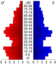
In the county, the population was spread out with 27.20% under the age of 18, 7.60% from 18 to 24, 27.20% from 25 to 44, 22.10% from 45 to 64, and 15.80% who were 65 years of age or older. The median age was 38 years. For every 100 females there were 99.80 males. For every 100 females age 18 and over, there were 98.00 males.
.
County (United States)
In the United States, a county is a geographic subdivision of a state , usually assigned some governmental authority. The term "county" is used in 48 of the 50 states; Louisiana is divided into parishes and Alaska into boroughs. Parishes and boroughs are called "county-equivalents" by the U.S...
located in the U.S. state
U.S. state
A U.S. state is any one of the 50 federated states of the United States of America that share sovereignty with the federal government. Because of this shared sovereignty, an American is a citizen both of the federal entity and of his or her state of domicile. Four states use the official title of...
of Wisconsin
Wisconsin
Wisconsin is a U.S. state located in the north-central United States and is part of the Midwest. It is bordered by Minnesota to the west, Iowa to the southwest, Illinois to the south, Lake Michigan to the east, Michigan to the northeast, and Lake Superior to the north. Wisconsin's capital is...
. As of 2000, the population was 16,137. Its county seat
County seat
A county seat is an administrative center, or seat of government, for a county or civil parish. The term is primarily used in the United States....
is Darlington
Darlington, Wisconsin
Darlington is a city in and the county seat of Lafayette County in the U.S. state of Wisconsin. The population was 2,451 at the 2010 census. The city is surrounded by the Town of Darlington.-History:...
.
Geography
According to the U.S. Census BureauUnited States Census Bureau
The United States Census Bureau is the government agency that is responsible for the United States Census. It also gathers other national demographic and economic data...
, the county has a total area of 635 square miles (1,644.6 km²), of which 634 square miles (1,642.1 km²) is land and 1 square miles (2.6 km²) (0.16%) is water.
Major highways
 U.S. Highway 151


Adjacent counties
- Grant CountyGrant County, WisconsinGrant County is a county located in the U.S. state of Wisconsin. As of 2000, the population was 49,597. Its county seat is Lancaster. Estimates for 2008 show a population of 49,238...
- west - Iowa CountyIowa County, WisconsinIowa County is a county located in the U.S. state of Wisconsin. As of 2000, the population was 22,780. Its county seat and largest city is Dodgeville.Iowa County is part of the Madison Metropolitan Statistical Area.-Geography:According to the U.S...
- north - Green CountyGreen County, WisconsinGreen County is a county located in the U.S. state of Wisconsin. As of 2000, the population was 33,647. Its county seat is Monroe.-Geography:According to the U.S...
- east - Stephenson County, IllinoisStephenson County, IllinoisAs of the census of 2000, there were 48,979 people, 19,785 households, and 13,473 families residing in the county. The population density was 87 people per square mile . There were 21,713 housing units at an average density of 38 per square mile...
- southeast - Jo Daviess County, IllinoisJo Daviess County, IllinoisJo Daviess County is a county located in the northwest corner of U.S. state of Illinois. According to the 2010 census, it has a population of 22,678, which is an increase of 1.7% from 22,289 in 2000. Its county seat is Galena....
- south
Demographics
As of the census
Census
A census is the procedure of systematically acquiring and recording information about the members of a given population. It is a regularly occurring and official count of a particular population. The term is used mostly in connection with national population and housing censuses; other common...
of 2000, there were 16,137 people, 6,211 households, and 4,378 families residing in the county. The population density
Population density
Population density is a measurement of population per unit area or unit volume. It is frequently applied to living organisms, and particularly to humans...
was 26 people per square mile (10/km²). There were 6,674 housing units at an average density of 10 per square mile (4/km²). The racial makeup of the county was 99.03% White
Race (United States Census)
Race and ethnicity in the United States Census, as defined by the Federal Office of Management and Budget and the United States Census Bureau, are self-identification data items in which residents choose the race or races with which they most closely identify, and indicate whether or not they are...
, 0.11% Black
Race (United States Census)
Race and ethnicity in the United States Census, as defined by the Federal Office of Management and Budget and the United States Census Bureau, are self-identification data items in which residents choose the race or races with which they most closely identify, and indicate whether or not they are...
or African American
Race (United States Census)
Race and ethnicity in the United States Census, as defined by the Federal Office of Management and Budget and the United States Census Bureau, are self-identification data items in which residents choose the race or races with which they most closely identify, and indicate whether or not they are...
, 0.11% Native American
Race (United States Census)
Race and ethnicity in the United States Census, as defined by the Federal Office of Management and Budget and the United States Census Bureau, are self-identification data items in which residents choose the race or races with which they most closely identify, and indicate whether or not they are...
, 0.22% Asian
Race (United States Census)
Race and ethnicity in the United States Census, as defined by the Federal Office of Management and Budget and the United States Census Bureau, are self-identification data items in which residents choose the race or races with which they most closely identify, and indicate whether or not they are...
, 0.04% Pacific Islander
Race (United States Census)
Race and ethnicity in the United States Census, as defined by the Federal Office of Management and Budget and the United States Census Bureau, are self-identification data items in which residents choose the race or races with which they most closely identify, and indicate whether or not they are...
, 0.14% from other races
Race (United States Census)
Race and ethnicity in the United States Census, as defined by the Federal Office of Management and Budget and the United States Census Bureau, are self-identification data items in which residents choose the race or races with which they most closely identify, and indicate whether or not they are...
, and 0.35% from two or more races. 0.57% of the population were Hispanic
Race (United States Census)
Race and ethnicity in the United States Census, as defined by the Federal Office of Management and Budget and the United States Census Bureau, are self-identification data items in which residents choose the race or races with which they most closely identify, and indicate whether or not they are...
or Latino
Race (United States Census)
Race and ethnicity in the United States Census, as defined by the Federal Office of Management and Budget and the United States Census Bureau, are self-identification data items in which residents choose the race or races with which they most closely identify, and indicate whether or not they are...
of any race. 33.8% were of German, 17.5% Norwegian, 13.6% Irish
Irish people
The Irish people are an ethnic group who originate in Ireland, an island in northwestern Europe. Ireland has been populated for around 9,000 years , with the Irish people's earliest ancestors recorded having legends of being descended from groups such as the Nemedians, Fomorians, Fir Bolg, Tuatha...
, 11.9% English
English people
The English are a nation and ethnic group native to England, who speak English. The English identity is of early mediaeval origin, when they were known in Old English as the Anglecynn. England is now a country of the United Kingdom, and the majority of English people in England are British Citizens...
, 6.8% Swiss and 6.0% American
United States
The United States of America is a federal constitutional republic comprising fifty states and a federal district...
ancestry according to Census 2000.
There were 6,211 households out of which 33.30% had children under the age of 18 living with them, 59.00% were married couples
Marriage
Marriage is a social union or legal contract between people that creates kinship. It is an institution in which interpersonal relationships, usually intimate and sexual, are acknowledged in a variety of ways, depending on the culture or subculture in which it is found...
living together, 7.60% had a female householder with no husband present, and 29.50% were non-families. 25.40% of all households were made up of individuals and 13.10% had someone living alone who was 65 years of age or older. The average household size was 2.57 and the average family size was 3.10.
In the county, the population was spread out with 27.20% under the age of 18, 7.60% from 18 to 24, 27.20% from 25 to 44, 22.10% from 45 to 64, and 15.80% who were 65 years of age or older. The median age was 38 years. For every 100 females there were 99.80 males. For every 100 females age 18 and over, there were 98.00 males.
History
The first settlements perfected by permanent occupation in Lafayette County were made during the year 1824 and were due to the existence of the lead mines, which led to early development and stability of the County. Lafayette County was formed in 1847 when the Legislature divided Iowa County into two separate counties. The Southern portion became Lafayette County, named after Marquis de Lafayette, hero of the American Revolutionary WarAmerican Revolutionary War
The American Revolutionary War , the American War of Independence, or simply the Revolutionary War, began as a war between the Kingdom of Great Britain and thirteen British colonies in North America, and ended in a global war between several European great powers.The war was the result of the...
.
Cities, villages, and towns
Unincorporated communities
- AvonAvon, Lafayette County, WisconsinAvon is an unincorporated community located in the town of Darlington, Lafayette County, Wisconsin, United States....
- CalamineCalamine, WisconsinCalamine is an unincorporated community in the town of Willow Springs in Lafayette County, Wisconsin, United States. The Cheese Country Trail runs through the community, as does the Pecatonica River....
- Elk GroveElk Grove (community), WisconsinElk Grove is an unincorporated community located in the town of Elk Grove, Lafayette County, Wisconsin, United States....
- EtnaEtna, WisconsinEtna is an unincorporated community located in the town of New Diggings, in Lafayette County, Wisconsin, United States. It lies at an elevation of 758 feet .-Notes:...
- FayetteFayette (community), WisconsinFayette is an unincorporated community located in the town of Fayette, Lafayette County, Wisconsin, United States....
- Five CornersFive Corners, Lafayette County, WisconsinFive Corners is an unincorporated community located in the town of Wiota, Lafayette County, Wisconsin, United States....
- IpswichIpswich, WisconsinIpswich is an unincorporated community located in the town of Elk Grove, Wisconsin, Lafayette County Wisconsin, United States....
- JenkinsvilleJenkinsville, WisconsinJenkinsville is an unincorporated community located in the town of New Diggings, Lafayette County, Wisconsin, United States....
- LamontLamont (community), WisconsinLamont is an unincorporated community in the town of Lamont, Lafayette County, Wisconsin, United States....
- Meekers GroveMeekers Grove, WisconsinMeekers Grove is an unincorporated community located in the town of Elk Grove, Lafayette County, Wisconsin, United States....
- Red RockRed Rock, WisconsinRed Rock is an unincorporated community located in the town of Darlington, Lafayette County, Wisconsin, United States....
- RiversideRiverside, Lafayette County, WisconsinRiverside is an unincorporated community located in the town of Gratiot, Lafayette County, Wisconsin, United States....
- SlatefordSlateford, WisconsinSlateford is an unincorporated community located in the town of Kendall, Lafayette County, Wisconsin, United States....
- StrawbridgeStrawbridge, WisconsinStrawbridge is an unincorporated community located in the town of Benton, Lafayette County, Wisconsin, United States....
- TrumanTruman, WisconsinTruman is an unincorporated community located in the town of Kendall, Lafayette County, Wisconsin, United States....
- White OakWhite Oak, WisconsinWhite Oak is an unincorporated community located in the town of White Oak Springs, Lafayette County, Wisconsin, United States....
- WoodfordWoodford, WisconsinWoodford is an unincorporated census-designated place located in Lafayette County, Wisconsin, United States. Woodford is south of Argyle, in the town of Wiota. Woodford has a post office with ZIP code 53599. As of the 2010 census, its population is 69....
- YellowstoneYellowstone, WisconsinYellowstone is an unincorporated community in the town of Fayette in Lafayette County, Wisconsin, United States.-History:Zenas H. Gurley, Sr. lead a branch of the Church of Jesus Christ of Latter Day Saints in the 1850s in Yellowstone....
See also
- National Register of Historic Places listings in Lafayette County, Wisconsin