

Edna Bay, Alaska
Encyclopedia
Edna Bay is a census-designated place
(CDP) on Kosciusko Island
in Prince of Wales-Hyder Census Area, Alaska
, United States
. The population was 49 at the 2000 census.
Edna Bay is one of only two populated towns on Kosciusko Island
, the other being Cape Pole
, and has both year-round and seasonal residents. Year-round residents are either retired, or work primarily in the fishing and logging industries. Some permanent residents also work seasonally off-island in various industries. Due to the very remote location of Edna Bay and the subsequent difficulty and expense of traveling between Edna Bay and larger S.E. Alaska communities, subsistence hunting, fishing, and gathering comprise a large portion of the livelihood activities for residents of Edna Bay. Starting in 2008 Edna Bay will also be home to an Engineering and Software Development company, made possible due to the broadband-internet service brought to the community by the State of Alaska and AT&T.
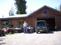
As of 2007 Edna Bay hosts a combined General Store/Post Office, a non-denominational Christian Church, several Saw-mills, and a Building Contractor. There is a small state-owned marina and float-plane dock which are unattended (self-service). At present there are no licensed inns, motels, hotels, lodges, or restaurants on Kosciusko Island. Visitors to Edna Bay without a local contact would be well advised to bring with them everything needed for remote outdoor survival, although food and a limited selection of non-food supplies can be purchased at the General Store located approx. 3 miles by road from the marina. The General Store and Post Office is open from 2PM to 5PM Tuesdays through Saturdays. Most land in and around Edna Bay is privately held and there are no public camping or day-use facilities. Un-escorted visitors should first check with the local residents before attempting to trespass, camp, or hunt in the area.
Residents of Edna Bay have available to them both land-line telephone and broadband internet. Cellular Phone service in Edna Bay is rare and intermittent. There is one outdoor public phone booth (located on the opposite side of the bay from the marina).
According to the United States Census Bureau
, the CDP has a total area of 58.8 square miles (152.3 km²), of which, 56 square miles (145 km²) of it is land and 2.8 square miles (7.3 km²) of it (4.80%) is water.
of 2000, there were 49 people, 19 households, and 14 families residing in the CDP. The population density
was 0.9 people per square mile (0.3/km²). There were 40 housing units at an average density of 0.7/sq mi (0.3/km²). The racial makeup of the CDP was 95.92% White
, and 4.08% from two or more races.
There were 19 households out of which 36.8% had children under the age of 18 living with them, 63.2% were married couples
living together, and 26.3% were non-families. 26.3% of all households were made up of individuals and 10.5% had someone living alone who was 65 years of age or older. The average household size was 2.58 and the average family size was 3.14.
 In the CDP the population was spread out with 28.6% under the age of 18, 6.1% from 18 to 24, 18.4% from 25 to 44, 40.8% from 45 to 64, and 6.1% who were 65 years of age or older. The median age was 37 years. For every 100 females there were 157.9 males. For every 100 females age 18 and over, there were 133.3 males.
The median income for a household in the CDP was $44,583, and the median income for a family was $49,063. Males had a median income of $40,625 versus $0 for females. The per capita income
for the CDP was $58,967. There were 15.4% of families and 23.1% of the population living below the poverty line, including 29.4% of under eighteens and 50.0% of those over 64.
Census-designated place
A census-designated place is a concentration of population identified by the United States Census Bureau for statistical purposes. CDPs are delineated for each decennial census as the statistical counterparts of incorporated places such as cities, towns and villages...
(CDP) on Kosciusko Island
Kosciusko Island
Kosciusko Island is an island in the Alexander Archipelago of southeastern Alaska, USA. It lies near the northwest corner of Prince of Wales Island, just across the El Capitan Passage from the larger island. Kosciusko Island has a land area of 171.585 sq mi , making it the 38th largest island in...
in Prince of Wales-Hyder Census Area, Alaska
Alaska
Alaska is the largest state in the United States by area. It is situated in the northwest extremity of the North American continent, with Canada to the east, the Arctic Ocean to the north, and the Pacific Ocean to the west and south, with Russia further west across the Bering Strait...
, United States
United States
The United States of America is a federal constitutional republic comprising fifty states and a federal district...
. The population was 49 at the 2000 census.
Edna Bay is one of only two populated towns on Kosciusko Island
Kosciusko Island
Kosciusko Island is an island in the Alexander Archipelago of southeastern Alaska, USA. It lies near the northwest corner of Prince of Wales Island, just across the El Capitan Passage from the larger island. Kosciusko Island has a land area of 171.585 sq mi , making it the 38th largest island in...
, the other being Cape Pole
Cape Pole
Cape Pole is one of only two populated towns on Kosciusko Island, the other being Edna Bay, and has both year-round and seasonal residents. It was a thriving logging camp from 1954 until it was shut down by a federal court ruling in 1978.-History:...
, and has both year-round and seasonal residents. Year-round residents are either retired, or work primarily in the fishing and logging industries. Some permanent residents also work seasonally off-island in various industries. Due to the very remote location of Edna Bay and the subsequent difficulty and expense of traveling between Edna Bay and larger S.E. Alaska communities, subsistence hunting, fishing, and gathering comprise a large portion of the livelihood activities for residents of Edna Bay. Starting in 2008 Edna Bay will also be home to an Engineering and Software Development company, made possible due to the broadband-internet service brought to the community by the State of Alaska and AT&T.
As of 2007 Edna Bay hosts a combined General Store/Post Office, a non-denominational Christian Church, several Saw-mills, and a Building Contractor. There is a small state-owned marina and float-plane dock which are unattended (self-service). At present there are no licensed inns, motels, hotels, lodges, or restaurants on Kosciusko Island. Visitors to Edna Bay without a local contact would be well advised to bring with them everything needed for remote outdoor survival, although food and a limited selection of non-food supplies can be purchased at the General Store located approx. 3 miles by road from the marina. The General Store and Post Office is open from 2PM to 5PM Tuesdays through Saturdays. Most land in and around Edna Bay is privately held and there are no public camping or day-use facilities. Un-escorted visitors should first check with the local residents before attempting to trespass, camp, or hunt in the area.
Residents of Edna Bay have available to them both land-line telephone and broadband internet. Cellular Phone service in Edna Bay is rare and intermittent. There is one outdoor public phone booth (located on the opposite side of the bay from the marina).
Geography
Edna Bay is located at 55°58′43"N 133°40′35"W (55.978539, -133.676356).According to the United States Census Bureau
United States Census Bureau
The United States Census Bureau is the government agency that is responsible for the United States Census. It also gathers other national demographic and economic data...
, the CDP has a total area of 58.8 square miles (152.3 km²), of which, 56 square miles (145 km²) of it is land and 2.8 square miles (7.3 km²) of it (4.80%) is water.
Demographics
As of the censusCensus
A census is the procedure of systematically acquiring and recording information about the members of a given population. It is a regularly occurring and official count of a particular population. The term is used mostly in connection with national population and housing censuses; other common...
of 2000, there were 49 people, 19 households, and 14 families residing in the CDP. The population density
Population density
Population density is a measurement of population per unit area or unit volume. It is frequently applied to living organisms, and particularly to humans...
was 0.9 people per square mile (0.3/km²). There were 40 housing units at an average density of 0.7/sq mi (0.3/km²). The racial makeup of the CDP was 95.92% White
Race (United States Census)
Race and ethnicity in the United States Census, as defined by the Federal Office of Management and Budget and the United States Census Bureau, are self-identification data items in which residents choose the race or races with which they most closely identify, and indicate whether or not they are...
, and 4.08% from two or more races.
There were 19 households out of which 36.8% had children under the age of 18 living with them, 63.2% were married couples
Marriage
Marriage is a social union or legal contract between people that creates kinship. It is an institution in which interpersonal relationships, usually intimate and sexual, are acknowledged in a variety of ways, depending on the culture or subculture in which it is found...
living together, and 26.3% were non-families. 26.3% of all households were made up of individuals and 10.5% had someone living alone who was 65 years of age or older. The average household size was 2.58 and the average family size was 3.14.
The median income for a household in the CDP was $44,583, and the median income for a family was $49,063. Males had a median income of $40,625 versus $0 for females. The per capita income
Per capita income
Per capita income or income per person is a measure of mean income within an economic aggregate, such as a country or city. It is calculated by taking a measure of all sources of income in the aggregate and dividing it by the total population...
for the CDP was $58,967. There were 15.4% of families and 23.1% of the population living below the poverty line, including 29.4% of under eighteens and 50.0% of those over 64.