

Acre (state)
Encyclopedia
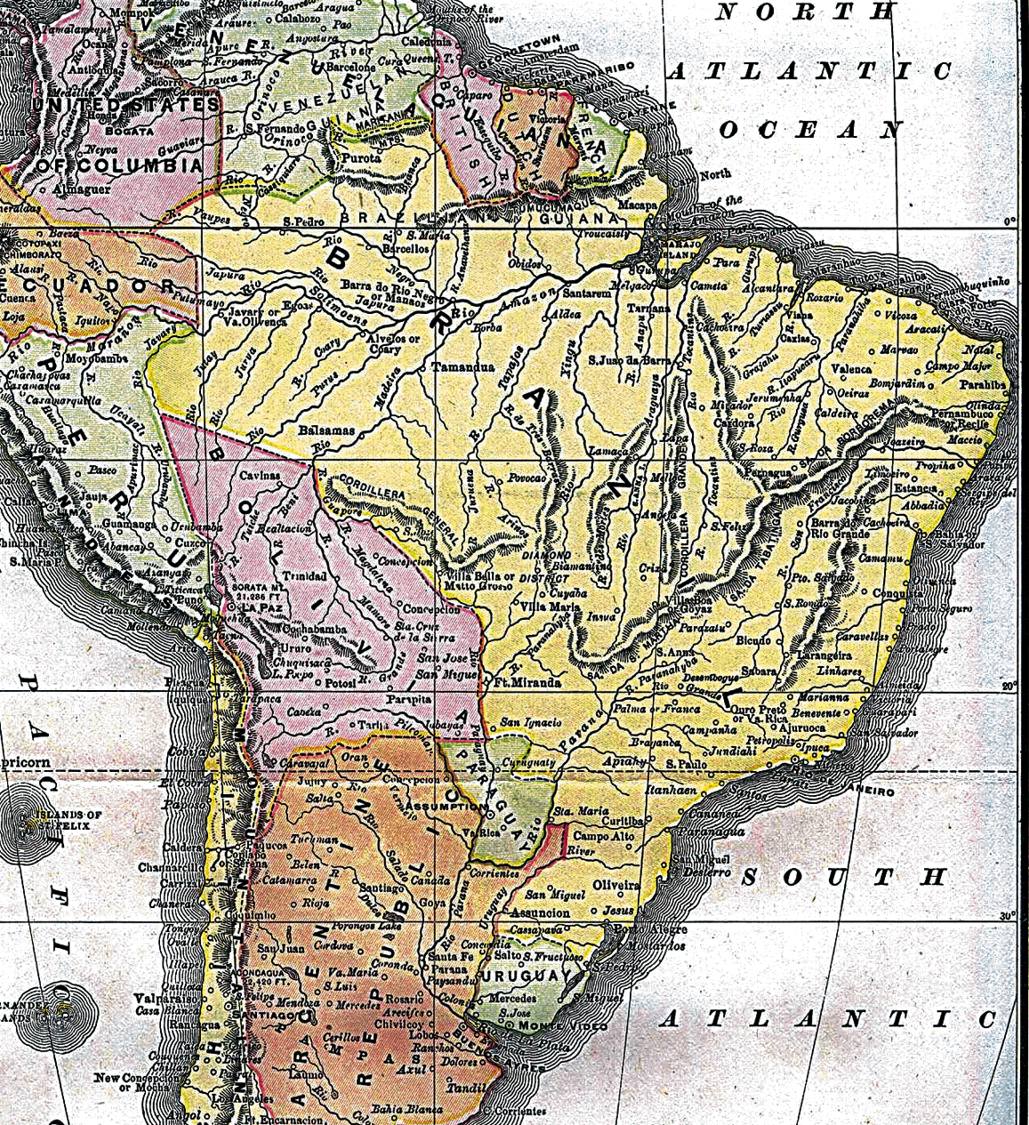
Acre (ˈakɾi) is one of the 27 states of Brazil. It is situated in the southwest of the Northern Region, bordering Amazonas to the north, Rondônia
to the east, Bolivia
to the southeast and the Ucayali Region
of Peru
to the south and west. It occupies an area of 152,581.4 km2, being slightly smaller than Tunisia
.
Its capital is the city of Rio Branco
. Other important places include: Cruzeiro do Sul
, Feijó, Sena Madureira
, Senador Guiomard
and Tarauacá
.
This state is the western extreme of the North Region
of Brazil
, with a one hour time difference from Brasília
(DF). In it is located the last Brazilian population to see the sun rise, on the Serra da Moa, on the Peruvian border. The intense extractive activity, which reached its height in the 20th century, attracted Brazilians from many regions to the state. From the mixture of sulista, paulista
, nordestino, and indigenous
traditions arose a diverse cuisine, which unites sun-dried meat (carne-de-sol
) with Arapaima
(pirarucu), a typical fish of the region. Such dishes are seasoned with tucupi
, a sauce made from manioc.
Fluvial transport, concentrated on the Juruá and Moa
rivers, in the western part of the state, and the Tarauacá
and Envira
Rivers in the northwest, is the principal form of circulation, especially between November and June, when the rain leaves the BR-364 impassable, which connects Rio Branco
to Cruzeiro do Sul
.
On the voyage which he made on the Purus
River in 1878, the colonizer, João Gabriel de Carvalho Melo, wrote from there to the merchant, Viscount of Santo Elias (from Pará), asking him for goods to be sent to the "mouth of the Aquiri River". Since in Belém
the proprietor of the commercial establishment and the employees were not able to understand João Gabriel's handwriting, or because he had hastily written Acri or Aqri, instead of Aquiri, the goods and the invoice arrived to the colonizer as having been sent to the Acre River.
Acre possesses some nicknames: the End of Brazil, The Rubber Tree State, the Latex State and the Western End.
The native inhabitants of Acre are called acrianos, in the singular acriano. Until the entry in force of the Orthographic Agreement of 1990, the correct spelling was acreano in the singular
and in the plural acreanos. In 2009, with the new orthographic agreement, the change generated controversy between the Academy of Letters of Acre (Academia Acreana de Letras) and the Brazilian Academy of Letters (Academia Brasileira de Letras
), alleging that the change would mean the denial of the state's historical and cultural roots, changing the last letter of the toponym from "E
" to "I
".
. It is located at 70º00'00" west longitude
from the Prime Meridian
and at 09º00'00" latitude
south of the equator
. In Brazil, the state is part of the North Region, forming borders with the states of Amazonas and Rondônia
, and with two countries: Peru
and Bolivia
.
Practically all of the terrain
of the state of Acre is part of the low sandstone
plateau
, or terra firme, morphological
unit which dominates most of the Brazil
ian Amazon
. These terranes rise, in Acre, from the southeast to the northeast, with very tabular topography
in general. In the extreme west is found the Serra da Contamana or Serra do Divisor, along the western border
, with the highest altitudes in the state (609 m) (1,998 ft). About 63% of state's surface
is lies between 200 and 300 m (656 and 984 ft) in height; 16% between 300 and 609 (984 and 1,998 ft); and 21% between 200 and 135 (656 and 443 ft).
The climate
is hot
and very humid, of the Am type in the Köppen climate classification
system, and the monthly average temperatures vary between 24 °C and 27 °C (75–80 °F), being the lowest average of the North Region. The rainfall reaches an annual total of 2,100 mm (83 inches), with a clear dry season
in the months of June, July, and August. The Amazon Rainforest
covers all of the state territory. Very rich in rubber trees of the most valuable species (Hevea brasiliensis) and Brazil nut trees (Bertholletia excelsa), the forest
guarantees that Acre is the greatest national producer of rubber
and nuts
. Acre's principal rivers, mostly navigable during the wet season (the Juruá
, Tarauacá
, Envira
, Purus, Iaco
, and Acre), cross the state with almost parallel courses which will only converge outside of its territory.
s and comprises the largest and most species-rich tract of tropical rainforest
in the world. Wet tropical forests are the most species-rich biome
, and tropical forests in the Americas are consistently more species-rich than the wet forests in Africa and Asia. As the largest tract of tropical rainforest in the Americas, the Amazonian rainforests have unparalleled biodiversity
. More than 1/3 of all species in the world live in the Amazon Rainforest.

.jpg)
.jpg)
.jpg) Until the beginning of the 20th century Acre belonged to Bolivia
Until the beginning of the 20th century Acre belonged to Bolivia
. However, since the beginning of the 19th century, a large part of its population were Brazilians who exploited rubber tree groves and who, in practice, achieved the creation of an independent territory.
In 1899, Bolivians tried to gain control of the area, but Brazilians revolted and there were border confrontations, generating the episode which became known as the Acre Revolution (Revolução Acreana).
On November 17, 1903, with the signing over and sale in the Treaty of Petrópolis
, Brazil received final possession of the region. Acre was then integrated into Brazil as a territory divided into three departments. The territory became Brazilian sovereignty in exchange for the payment of two million pounds sterling, land taken from Mato Grosso
and in accordance with the construction of the Madeira-Mamoré railway.
Having been united in 1920, on June 15, 1962 it was elevated to the category of state, being the first to be governed by a woman, the teacher Iolanda Fleming
.
During the second world war, the rubber tree groves of Malaysia were taken by the Japanese, and Acre thus left a great mark on western and world history, helping to change the course of the war in favor of the allies. This was thanks to the Rubber Soldiers, natives mostly of the Ceará plantation. It was perhaps due to Acre and its decisive contribution to the allied victory, that Brazil received North American resources to form the National Steel Company (Companhia Siderúrgica Nacional), and thus aid in the industrialization of the Central-south, which was until such time mostly stagnant, and which did not yet possess basic heavy industries.
On April 4 of 2008, Acre won a judicial debate with the state of Amazonas in relation to the dispute surrounding the Cunha Gomes Line, which culminated in the annex of part of the municipalities of Envira
, Guajará
, Boca do Acre
, Pauini
, Eirunepé
and Ipixuna
. The territorial redefinition consolidated the incorporation of 1.2 million hectares of the Liberdade, Gregório, and Mogno forest complex to the territory of Acre, which corresponds to 11,583.87 km2.
(1750) and Santo Ildefonso (1777). Both of the treaties, based on the explorations of Manuel Félix de Leme of the Guaporé and Madeira drainage basins, established the riverbeds of the Mamoré and Guaporé to their maximum western limits on the left bank of the Javari as a dividing line between the respective areas in question.
The settlement of the zone, stimulated by the creation of the new Royal Captainship of Mato Grosso (1751), occurred in the direction of the frontier, causing several important centers to emerge: Vila Bela (1752) on the banks of the Guaporé, Vila Maria
(1778) on the Paraguay River
, and Casalvasco (1783). Until the mid 19th century, a systematic settling of the area was not thought of. At that time, the great virgin source of rubber found there would attract commercial interest, provoking its colonization.
The economic politics of the empire, directed towards agricultural exportation activities based on coffee, did not permit the utilization and incorporation of the territories of the extreme west. From this negligence it happened that in Cândido Mendes de Almeida's Atlas of the Empire of Brazil (1868), a model of its time, the Acre River and its principal tributaries did not appear, being completely unknown to geographers.
Notwithstanding such politics, some few armed bands of Brazilian explorers exploited the rural and unpopulated region, not knowing whether they pertained to Brazil
, Peru
, or Bolivia
. Hence, still in the mid 19th century, fed by the drive which the search for rubber occasioned, solicited as it was on the international market, various expeditions searched out the area seeking to facilitate the installation of colonists. At that time, João Rodrigues Cametá initiated the conquest of the Purus
River; Manuel Urbano da Encarnação, an Indian with an extensive knowledge of the region, reached the Acre River, traveling up it as far as the vicinity of the Xapuri
; and João da Cunha Correia reached the drainage basin
of the upper Tarauacá
. All this clearing took place, for the most part, on Bolivia
n land.
Exploitative activities, the industrial importance of the rubber reserves, and the penetration of Brazilian colonists in the region raised the attention of Bolivia
, which solicited a better fixation of boundaries. After much failed negotiation, in 1867 the Treaty of Ayacucho
was signed, which recognized the colonial uti possidetis
. A border was established parallel to the confluence of the Beni
and Mamoré
Rivers running eastward to the headwaters of the Javari River, even though the source of this river was not yet known.
increased. Plantations multiplied in this manner in the valleys of the Acre, Purus
, and farther west, the Tarauacá
: in one year (1873-1874), in the drainage basin
of the Purus
, the population rose from around one thousand to four thousand inhabitants. On the other hand, the imperial government, already sensitive to the resulting offerings of rubber
, considered the entire valley
of the Purus to be Brazilian.
Also, in the second half of the 19th century, disturbances were registered in the demographic and geo-economic balance of the empire, with the coffee boom in the south channeling financial resources and workers, in detriment to the northeast. The growing impoverishment of that region stimulated migratory waves to the states of Rio de Janeiro
, Minas Gerais
, and São Paulo
. The movement of population became particularly active during the prolonged drought of the northeastern interior, from 1877 to 1880, expelling hundreds of Cearenses, who headed for the rubber plantations in search of work.
The advance of Cearense migration proceeded to the banks of the Juruá
and accelerated the occupation of land which Bolivia
would later reclaim. The great fluvial river beds and their tributary
systems were then intensely trafficked by small ship fleets of varied transport, transporting colonists, goods, and supply material to the most isolated nuclei. The governments of Amazonas and Pará
quickly instituted the establishment of supply houses, which financed various types of operations, guaranteed credit, and promoted the commercial incentive of the rubber tree groves.
The rubber
race assumed proportions similar to those of the search for gold veins in the 18th century. The results were equal. The situation drew the attention of the government to the economic utilization of an almost completely unknown area, besides permitting -as in a colony- the patrimonial incorporation of new regions, on the basis of penetration movements by private enterprise.
n official, José Manuel Pando
, alerted his government to the fact that in the drainage basin of the Juruá
there were more than three hundred rubber plantations, with the occupation by Brazilians taking root more and more rapidly on Bolivia
n soil. The Brazilian penetration had advanced in depth west from the 64th meridian to beyond the 72nd, in an extension of one thousand kilometers, even though the borders had already been fixed above the confluence of the Beni
and Mamoré
Rivers according to the Treaty of 1867.
In 1895 a new commission for the settlement of demarcation was created. The Brazilian representative, Gregório Taumaturgo de Azevedo, resigned after verifying that the ratification of the Treaty of 1867 would harm the rubber gatherers which were installed there. In 1899, the Bolivians established an administrative post in Puerto Alonso, exacting taxes and customs duties upon Brazilian activities. The following year, Brazil accepted the sovereignty of Bolivia
in the zone, when it officially recognized the old boundaries at the confluence of the Beni
and Mamoré
.
The rubber gatherers, distant from the diplomatic process, judged their interests to have been cheated, and initiated insurrection movements. In the same year that Bolivia
implanted administration in Puerto Alonso (1899), two serious contestations occurred.
In April, a Cearense
lawyer, José carvalho, led an armed movement, which culminated in the expulsion of the Bolivian authorities. Shortly thereafter, Bolivia
began negotiations with an Anglo-American trust, the Bolivian Syndicate, in order to promote, with exceptional force (exacting of taxes, armed force), the political and economic incorporation of Acre into its territory. The governor of Amazonas, Ramalho Júnior, informed of the agreement by a functionary of the Bolivian consulate in Belém
, Luis Gálvez Rodríguez de Arias, sent military contingents forward to occupy Puerto Alonso. Gálvez proclaimed the independence of Acre, in the form of a republic, becoming its president with the acquiescence of the rubber gatherers. Under protests from Bolivia
, President Campos Sales abolished the ephemeral republic (March, 1900).
Bolivians, reinstated in the region, suffered, still in 1900, the assault of the so-called Floriano Peixoto expedition or "expedition of the poets", thus called, for being constituted for the most part of intellectual bohemians from Manaus. The conflict did not have great consequences, since, following brief fighting in the area surrounding Puerto Alonso, the expedition was completely scattered.
Ultimately, the Bolivia
n government signed a contract with the Bolivian Syndicate (July, 1901). The Brazilian congress, shocked by the arbitrariness of the act, took measures, canceling commercial accords and navigation between the two countries, and suspending the right of travel to Bolivia
.
At the same time, Brazilians organized an armed assault of great size on the conflicted area. The operations were led by a former student of the Military School of Rio Grande do Sul (Escola Militar do Rio Grande do Sul), José Plácido de Castro. The rubber gatherers occupied the village of Xapuri
in Alto Acre (August, 1902), apprehending the Bolivian authorities. Finally, Plácido de Castro
's forces besieged Puerto Alonso, proclaiming the Independent State of Acre, after the capitulation of Bolivian troops (February, 1903).
, proclaimed governor of the new Independent State of Acre
, it was left to discuss the question of borders in the diplomatic sphere. The Baron of Rio Branco, who had just assumed the role of minister of foreign relations, immediately opened channels which were meant to have put an end to the question.
The simplest problem, with the Bolivian Syndicate, was resolved by means of the compensation of one hundred ten thousand pounds to renounce the contract (February, 1903). Next, commercial relations were reestablished with Bolivia
, while a part of the territory on the upper Purus
and Juruá
, militarily occupied (March, 1903) was declared litigious. From the subsequent talks, it followed that Bolivia
would cede an area of 142,800 km2, in exchange for two million pounds sterling, paid in two parcels. Brazil committed to the construction of a Madeira-Mamoré Railway, connecting Porto Velho
to Guajará-Mirim
, at the confluence of the Beni
and the Madeira
. Such were the principal stipulations of the Treaty of Petrópolis
(November 17, 1903), through which Brazil
acquired the future territory, now state of Acre.
There remained the question of Peru
, which also claimed sovereignty over the entire territory of Acre and part of the state of Amazonas, in light of colonial titles. After armed conflicts between Brazilians and Peruvians on the upper Purus
and Juruá
, a joint administration was established in those regions (1904). The studies for the fixation of borders proceeded until the end of 1909, when a treaty was signed which completed the political integration of Acre into Brazil
ian territory.
, accompanied by important contributions to the economic projection of the country. Exercising a prominent role in national exportation until 1913, when rubber was introduced to European and North American
markets, Acre enjoyed a period of great prosperity: at the turn of the century, in a period of less than ten years, it boasted more than 50,000 inhabitants.
It may be asserted that all the endeavors towards the integration of Acre into Brazilian life correspond to the parallel efforts of the federal government, from 1946 on, to the effect of recuperating the economy of the Amazon
, including it in regional development
projects.
Attending to the judicial arrangements of the Treaty of Petrópolis
, President Rodrigues Alves sanctioned the law which created the Territory of Acre (1904), further dividing it into three departments: Alto Acre, Alto Purus, and Alto Juruá, the latter being separated to form Alto Tarauacá (1912). The departmental administration was exercised until 1921 by mayors appointed by the President of Brazil
. At that time the arrangements were altered, passing the administration to a governor. The second Constitution of Brazil
(1934) conceded to Acre the right to elect representatives to the National Congress of Brazil
.
During the Estado Novo
(New State) political ideas involving the valorization of the interior took hold, with the intention of promoting the articulation of more isolated areas. Thereafter, the vote of 1946 commended the channeling of budgetary resources from the Union to the Amazon
, determining that the Territory of Acre would be elevated to the condition of state as soon as its revenue reached the equivalent of the lowest state tax exaction.
In the decade of 1960, the second cycle of efforts to accelerate the progress of the Amazon area was begun with the Superintendency of the Development of the Amazon (Superintendência de Desenvolvimento da Amazônia
or SUDAM, 1966). Better networking of regional sub-sectors within the state was sought out, thus connecting the branch lines of the Transamazônica, which connected Rio Branco
and Brasileia
, on the upper course of the Acre River, and Cruzeiro do Sul
, on the banks of the Juruá
, crossing the valleys of the Purus
and the Tarauacá
. Planning politics developed, therefore, destined to correct the demographic, economic, and political distortions of national integration.
 According to the IBGE
of 2007, there were 664,000 people residing in the state. The population density was 4.5 inh./km2.
Urbanization
: 69.6% (2006); Population growth
: 3.3% (1991–2000); House
s: 162,000 (2006).
The last PNAD (National Research for Sample of Domiciles) census revealed the following numbers: 441,000 Brown (Multiracial) people (66.5%), 172,000 White
(26.0%), 45,000 Black
(6.8%), 4,000 Asian
or Amerindian
people (0.7%).
.jpg) The service sector is the largest component of GDP at 66%, followed by the industrial sector at 28.1%. Agriculture
The service sector is the largest component of GDP at 66%, followed by the industrial sector at 28.1%. Agriculture
represents 5.9%, of GDP (2004). Acre exports: wood
85.6%, poultry (chicken and wild turkey
) 4.7%, wood
products 1.7% (2002).
Share of the Brazilian economy: 0.2% (2005).
is the official national language, and thus the primary language taught in schools. English and Spanish are also part of the official high school curriculum.
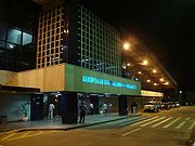 Rio Branco International Airport is located in a rural zone of the municipality of Rio Branco, in the state of Acre. It was opened on November 2, 1999 with a unique characteristic: it moved 22 kilometers away from the previous airport site. Rio Branco Airport serves domestic and international flights (by scheduled carriers and air taxi firms) along with general and military aviation. The terminal can receive 270 thousand passengers a year and serves an average of 14 daily operations.
Cruzeiro do Sul International Airport is located 18 kilometers away from the city center, which helps access to the Alto Juruá region. It was opened on October 28, 1970 and absorbed by Infraero
on March 31, 1980. The airport infrastructure was built in 1976 by the municipal government. In 1994 the runway was totally renovated.
 Rio Branco
provides visitors and residents with various sport activities.
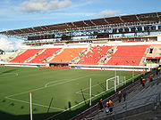
The Arena da Floresta
stadium in Rio Branco
was one of the 18 candidates to host games in the 2014 FIFA World Cup
, which will be held in Brazil
, but did not make the final 12 chosen.
) of the Arawan family as well as Yine (Manchineri) and Ashaninka
(Kampa) of the Arawakan family.
and two mesoregions
:
Rondônia
Rondônia is a state in Brazil, located in the north-western part of the country. To the west is a short border with the state of Acre, to the north is the state of Amazonas, in the east is Mato Grosso, and in the south is Bolivia. Its capital is Porto Velho. The state was named after Candido Rondon...
to the east, Bolivia
Bolivia
Bolivia officially known as Plurinational State of Bolivia , is a landlocked country in central South America. It is the poorest country in South America...
to the southeast and the Ucayali Region
Ucayali Region
Ucayali is an inland region in Peru. Located in the Amazon rainforest, its name is derived from the Ucayali River. The regional capital is the city of Pucallpa.-Boundaries:...
of Peru
Peru
Peru , officially the Republic of Peru , is a country in western South America. It is bordered on the north by Ecuador and Colombia, on the east by Brazil, on the southeast by Bolivia, on the south by Chile, and on the west by the Pacific Ocean....
to the south and west. It occupies an area of 152,581.4 km2, being slightly smaller than Tunisia
Tunisia
Tunisia , officially the Tunisian RepublicThe long name of Tunisia in other languages used in the country is: , is the northernmost country in Africa. It is a Maghreb country and is bordered by Algeria to the west, Libya to the southeast, and the Mediterranean Sea to the north and east. Its area...
.
Its capital is the city of Rio Branco
Rio Branco
Rio Branco is a Brazilian city, capital of Acre. Located in the Valley of Acre in northern Brazil, it is the most populous county in the state, with 305,954 inhabitants, according to a 2009 estimate - almost half the state population....
. Other important places include: Cruzeiro do Sul
Cruzeiro do Sul, Acre
Cruzeiro do Sul is a municipality located on the Jurua river in the west of the Brazilian state of Acre. Its population is 73, 948 and its area is 7,925 km²....
, Feijó, Sena Madureira
Sena Madureira
Sena Madureira is a municipality located in the center of the Brazilian state of Acre. Its population is 34 230 and its area is 25,278 km², making it the largest city in the state. It has a climate which combines temperatures of almost 100F with humidities in the upper 90s percent, all year...
, Senador Guiomard
Senador Guiomard
Senador Guiomard is a municipality located in the northeast of the Brazilian state of Acre. Its population is 18,863 and its area is 2,047 km²....
and Tarauacá
Tarauacá
Tarauacá is a municipality located in the northwest of the Brazilian state of Acre. Tarauacá has a population of 32,171 people and has an area ....
.
This state is the western extreme of the North Region
North Region, Brazil
The North Region of Brazil is the largest Region of Brazil, corresponding to 45.27% of the national territory. It is the least inhabited of the country, and contributes with a minor percentage in the national GDP and population...
of Brazil
Brazil
Brazil , officially the Federative Republic of Brazil , is the largest country in South America. It is the world's fifth largest country, both by geographical area and by population with over 192 million people...
, with a one hour time difference from Brasília
Brasília
Brasília is the capital city of Brazil. The name is commonly spelled Brasilia in English. The city and its District are located in the Central-West region of the country, along a plateau known as Planalto Central. It has a population of about 2,557,000 as of the 2008 IBGE estimate, making it the...
(DF). In it is located the last Brazilian population to see the sun rise, on the Serra da Moa, on the Peruvian border. The intense extractive activity, which reached its height in the 20th century, attracted Brazilians from many regions to the state. From the mixture of sulista, paulista
Paulista
Paulista is a city in Pernambuco, Brazil, population according to IBGE/2009, 319.373 people making it the 4th most populous city in PE). Its near 6 cities plus the ocean and has the highest HDI of the metro area. It is the birthplace of footballer Rivaldo, and is also famous for its beaches;...
, nordestino, and indigenous
Indigenous peoples
Indigenous peoples are ethnic groups that are defined as indigenous according to one of the various definitions of the term, there is no universally accepted definition but most of which carry connotations of being the "original inhabitants" of a territory....
traditions arose a diverse cuisine, which unites sun-dried meat (carne-de-sol
Carne-de-sol
Carne de sol , also called jabá is a dish from northeastern Brazil. It consists of heavily salted beef, which is exposed to the sun for one or two days to cure....
) with Arapaima
Arapaima
The arapaima, pirarucu, or paiche is a South American tropical freshwater fish. It is a living fossil and one of the largest freshwater fishes in the world.-Anatomy and morphology:...
(pirarucu), a typical fish of the region. Such dishes are seasoned with tucupi
Tucupi
Tucupi is a yellow sauce extracted from wild manioc root, which is peeled, grated and then the juice is squeezed out . After being squeezed through the tipiti, the juice is left to "rest" so that the starch separates from the liquid...
, a sauce made from manioc.
Fluvial transport, concentrated on the Juruá and Moa
Moa River
The Moa River is a river in west Africa. It arises in the highlands of Guinea and flows southwest, forming parts of the Guinea–Liberia and the Guinea – Sierra Leone borders. It flows into the Southern Province of Sierra Leone. Both Tiwai Island and Sulima are located on the Moa....
rivers, in the western part of the state, and the Tarauacá
Tarauacá
Tarauacá is a municipality located in the northwest of the Brazilian state of Acre. Tarauacá has a population of 32,171 people and has an area ....
and Envira
Envira
Envira is a municipality located in the Brazilian state of Amazonas. Its population was 13,548 as of 2005, and its area is 13,369 km²....
Rivers in the northwest, is the principal form of circulation, especially between November and June, when the rain leaves the BR-364 impassable, which connects Rio Branco
Rio Branco
Rio Branco is a Brazilian city, capital of Acre. Located in the Valley of Acre in northern Brazil, it is the most populous county in the state, with 305,954 inhabitants, according to a 2009 estimate - almost half the state population....
to Cruzeiro do Sul
Cruzeiro do Sul, Acre
Cruzeiro do Sul is a municipality located on the Jurua river in the west of the Brazilian state of Acre. Its population is 73, 948 and its area is 7,925 km²....
.
Etymology
The name, which passed from the river to the territory in 1904, and to the state in 1962, perhaps originates from the tupi word a'kir ü "green river" or from the form a'kir, of the tupi word ker, "to sleep, to rest"; but it is almost certain to be a deformation of Aquiri, the spelling which explorers of the region utilized to express Umákürü, or Uakiry, a term from the Ipurinã dialect. There is also a hypothesis that Acquiri derives from Yasi'ri, or Ysi'ri, meaning "flowing or swift water".On the voyage which he made on the Purus
Purus
The Purus is a tributary of the Amazon River in South America. Its drainage basin is , and the mean discharge is 8,400 m³/s.It enters the Amazon River west of the Madeira River, which it parallels as far south as the falls of the latter stream...
River in 1878, the colonizer, João Gabriel de Carvalho Melo, wrote from there to the merchant, Viscount of Santo Elias (from Pará), asking him for goods to be sent to the "mouth of the Aquiri River". Since in Belém
Belém
Belém is a Brazilian city, the capital and largest city of state of Pará, in the country's north region. It is the entrance gate to the Amazon with a busy port, airport and bus/coach station...
the proprietor of the commercial establishment and the employees were not able to understand João Gabriel's handwriting, or because he had hastily written Acri or Aqri, instead of Aquiri, the goods and the invoice arrived to the colonizer as having been sent to the Acre River.
Acre possesses some nicknames: the End of Brazil, The Rubber Tree State, the Latex State and the Western End.
The native inhabitants of Acre are called acrianos, in the singular acriano. Until the entry in force of the Orthographic Agreement of 1990, the correct spelling was acreano in the singular
Grammatical number
In linguistics, grammatical number is a grammatical category of nouns, pronouns, and adjective and verb agreement that expresses count distinctions ....
and in the plural acreanos. In 2009, with the new orthographic agreement, the change generated controversy between the Academy of Letters of Acre (Academia Acreana de Letras) and the Brazilian Academy of Letters (Academia Brasileira de Letras
Academia Brasileira de Letras
Academia Brasileira de Letras is a Brazilian literary non-profit society established at the end of the 19th century by a group of 40 writers and poets inspired by the Académie Française. The first president, Machado de Assis, declared its foundation on December 15, 1896, with the statutes being...
), alleging that the change would mean the denial of the state's historical and cultural roots, changing the last letter of the toponym from "E
E
E is the fifth letter and a vowel in the basic modern Latin alphabet. It is the most commonly used letter in the Czech, Danish, Dutch, English, French, German, Hungarian, Latin, Norwegian, Spanish, and Swedish languages.-History:...
" to "I
I
I is the ninth letter and a vowel in the basic modern Latin alphabet.-History:In Semitic, the letter may have originated in a hieroglyph for an arm that represented a voiced pharyngeal fricative in Egyptian, but was reassigned to by Semites, because their word for "arm" began with that sound...
".
Geography
The state of Acre occupies an area of 152,581 km2 (58,911 mi2) in the extreme west of BrazilBrazil
Brazil , officially the Federative Republic of Brazil , is the largest country in South America. It is the world's fifth largest country, both by geographical area and by population with over 192 million people...
. It is located at 70º00'00" west longitude
Longitude
Longitude is a geographic coordinate that specifies the east-west position of a point on the Earth's surface. It is an angular measurement, usually expressed in degrees, minutes and seconds, and denoted by the Greek letter lambda ....
from the Prime Meridian
Prime Meridian
The Prime Meridian is the meridian at which the longitude is defined to be 0°.The Prime Meridian and its opposite the 180th meridian , which the International Date Line generally follows, form a great circle that divides the Earth into the Eastern and Western Hemispheres.An international...
and at 09º00'00" latitude
Latitude
In geography, the latitude of a location on the Earth is the angular distance of that location south or north of the Equator. The latitude is an angle, and is usually measured in degrees . The equator has a latitude of 0°, the North pole has a latitude of 90° north , and the South pole has a...
south of the equator
Equator
An equator is the intersection of a sphere's surface with the plane perpendicular to the sphere's axis of rotation and containing the sphere's center of mass....
. In Brazil, the state is part of the North Region, forming borders with the states of Amazonas and Rondônia
Rondônia
Rondônia is a state in Brazil, located in the north-western part of the country. To the west is a short border with the state of Acre, to the north is the state of Amazonas, in the east is Mato Grosso, and in the south is Bolivia. Its capital is Porto Velho. The state was named after Candido Rondon...
, and with two countries: Peru
Peru
Peru , officially the Republic of Peru , is a country in western South America. It is bordered on the north by Ecuador and Colombia, on the east by Brazil, on the southeast by Bolivia, on the south by Chile, and on the west by the Pacific Ocean....
and Bolivia
Bolivia
Bolivia officially known as Plurinational State of Bolivia , is a landlocked country in central South America. It is the poorest country in South America...
.
Practically all of the terrain
Terrain
Terrain, or land relief, is the vertical and horizontal dimension of land surface. When relief is described underwater, the term bathymetry is used...
of the state of Acre is part of the low sandstone
Sandstone
Sandstone is a sedimentary rock composed mainly of sand-sized minerals or rock grains.Most sandstone is composed of quartz and/or feldspar because these are the most common minerals in the Earth's crust. Like sand, sandstone may be any colour, but the most common colours are tan, brown, yellow,...
plateau
Plateau
In geology and earth science, a plateau , also called a high plain or tableland, is an area of highland, usually consisting of relatively flat terrain. A highly eroded plateau is called a dissected plateau...
, or terra firme, morphological
Geomorphology
Geomorphology is the scientific study of landforms and the processes that shape them...
unit which dominates most of the Brazil
Brazil
Brazil , officially the Federative Republic of Brazil , is the largest country in South America. It is the world's fifth largest country, both by geographical area and by population with over 192 million people...
ian Amazon
Amazon Basin
The Amazon Basin is the part of South America drained by the Amazon River and its tributaries that drains an area of about , or roughly 40 percent of South America. The basin is located in the countries of Bolivia, Brazil, Colombia, Ecuador, Guyana, Peru, and Venezuela...
. These terranes rise, in Acre, from the southeast to the northeast, with very tabular topography
Topography
Topography is the study of Earth's surface shape and features or those ofplanets, moons, and asteroids...
in general. In the extreme west is found the Serra da Contamana or Serra do Divisor, along the western border
Border
Borders define geographic boundaries of political entities or legal jurisdictions, such as governments, sovereign states, federated states and other subnational entities. Some borders—such as a state's internal administrative borders, or inter-state borders within the Schengen Area—are open and...
, with the highest altitudes in the state (609 m) (1,998 ft). About 63% of state's surface
Surface
In mathematics, specifically in topology, a surface is a two-dimensional topological manifold. The most familiar examples are those that arise as the boundaries of solid objects in ordinary three-dimensional Euclidean space R3 — for example, the surface of a ball...
is lies between 200 and 300 m (656 and 984 ft) in height; 16% between 300 and 609 (984 and 1,998 ft); and 21% between 200 and 135 (656 and 443 ft).
The climate
Climate
Climate encompasses the statistics of temperature, humidity, atmospheric pressure, wind, rainfall, atmospheric particle count and other meteorological elemental measurements in a given region over long periods...
is hot
Temperature
Temperature is a physical property of matter that quantitatively expresses the common notions of hot and cold. Objects of low temperature are cold, while various degrees of higher temperatures are referred to as warm or hot...
and very humid, of the Am type in the Köppen climate classification
Köppen climate classification
The Köppen climate classification is one of the most widely used climate classification systems. It was first published by Crimea German climatologist Wladimir Köppen in 1884, with several later modifications by Köppen himself, notably in 1918 and 1936...
system, and the monthly average temperatures vary between 24 °C and 27 °C (75–80 °F), being the lowest average of the North Region. The rainfall reaches an annual total of 2,100 mm (83 inches), with a clear dry season
Dry season
The dry season is a term commonly used when describing the weather in the tropics. The weather in the tropics is dominated by the tropical rain belt, which oscillates from the northern to the southern tropics over the course of the year...
in the months of June, July, and August. The Amazon Rainforest
Amazon Rainforest
The Amazon Rainforest , also known in English as Amazonia or the Amazon Jungle, is a moist broadleaf forest that covers most of the Amazon Basin of South America...
covers all of the state territory. Very rich in rubber trees of the most valuable species (Hevea brasiliensis) and Brazil nut trees (Bertholletia excelsa), the forest
Forest
A forest, also referred to as a wood or the woods, is an area with a high density of trees. As with cities, depending where you are in the world, what is considered a forest may vary significantly in size and have various classification according to how and what of the forest is composed...
guarantees that Acre is the greatest national producer of rubber
Rubber
Natural rubber, also called India rubber or caoutchouc, is an elastomer that was originally derived from latex, a milky colloid produced by some plants. The plants would be ‘tapped’, that is, an incision made into the bark of the tree and the sticky, milk colored latex sap collected and refined...
and nuts
Nut (fruit)
A nut is a hard-shelled fruit of some plants having an indehiscent seed. While a wide variety of dried seeds and fruits are called nuts in English, only a certain number of them are considered by biologists to be true nuts...
. Acre's principal rivers, mostly navigable during the wet season (the Juruá
Jurua
The Juruá River is a southern affluent river of the Amazon River west of the Purus River, sharing with this the bottom of the immense inland Amazon depression, and having all the characteristics of the Purus as regards curvature, sluggishness and general features of the low, half-flooded forest...
, Tarauacá
Tarauacá River
Tarauacá River is a river of Amazonas and Acre states in western Brazil.-References:*...
, Envira
Envira River
Envira River is a river of Acre and Amazonas states in western Brazil.-References:*...
, Purus, Iaco
Iaco River
Iaco River is a river of Acre and Amazonas states in western Brazil.-References:*...
, and Acre), cross the state with almost parallel courses which will only converge outside of its territory.
Vegetation
The Amazon represents over half of the planet's remaining rainforestRainforest
Rainforests are forests characterized by high rainfall, with definitions based on a minimum normal annual rainfall of 1750-2000 mm...
s and comprises the largest and most species-rich tract of tropical rainforest
Tropical rainforest
A tropical rainforest is an ecosystem type that occurs roughly within the latitudes 28 degrees north or south of the equator . This ecosystem experiences high average temperatures and a significant amount of rainfall...
in the world. Wet tropical forests are the most species-rich biome
Biome
Biomes are climatically and geographically defined as similar climatic conditions on the Earth, such as communities of plants, animals, and soil organisms, and are often referred to as ecosystems. Some parts of the earth have more or less the same kind of abiotic and biotic factors spread over a...
, and tropical forests in the Americas are consistently more species-rich than the wet forests in Africa and Asia. As the largest tract of tropical rainforest in the Americas, the Amazonian rainforests have unparalleled biodiversity
Biodiversity
Biodiversity is the degree of variation of life forms within a given ecosystem, biome, or an entire planet. Biodiversity is a measure of the health of ecosystems. Biodiversity is in part a function of climate. In terrestrial habitats, tropical regions are typically rich whereas polar regions...
. More than 1/3 of all species in the world live in the Amazon Rainforest.
History
Bolivia
Bolivia officially known as Plurinational State of Bolivia , is a landlocked country in central South America. It is the poorest country in South America...
. However, since the beginning of the 19th century, a large part of its population were Brazilians who exploited rubber tree groves and who, in practice, achieved the creation of an independent territory.
In 1899, Bolivians tried to gain control of the area, but Brazilians revolted and there were border confrontations, generating the episode which became known as the Acre Revolution (Revolução Acreana).
On November 17, 1903, with the signing over and sale in the Treaty of Petrópolis
Treaty of Petrópolis
The Treaty of Petrópolis, signed on November 11, 1903, ended tensions between Bolivia and Brazil over the then-Bolivian territory of Acre , a desirable territory during the contemporary rubber boom....
, Brazil received final possession of the region. Acre was then integrated into Brazil as a territory divided into three departments. The territory became Brazilian sovereignty in exchange for the payment of two million pounds sterling, land taken from Mato Grosso
Mato Grosso
Mato Grosso is one of the states of Brazil, the third largest in area, located in the western part of the country.Neighboring states are Rondônia, Amazonas, Pará, Tocantins, Goiás and Mato Grosso do Sul. It also borders Bolivia to the southwest...
and in accordance with the construction of the Madeira-Mamoré railway.
Having been united in 1920, on June 15, 1962 it was elevated to the category of state, being the first to be governed by a woman, the teacher Iolanda Fleming
Iolanda Fleming
Iolanda Lima Fleming was the first Brazilian woman to be the governor of a state. She served as the Governor of Acre in 1986.- References :...
.
During the second world war, the rubber tree groves of Malaysia were taken by the Japanese, and Acre thus left a great mark on western and world history, helping to change the course of the war in favor of the allies. This was thanks to the Rubber Soldiers, natives mostly of the Ceará plantation. It was perhaps due to Acre and its decisive contribution to the allied victory, that Brazil received North American resources to form the National Steel Company (Companhia Siderúrgica Nacional), and thus aid in the industrialization of the Central-south, which was until such time mostly stagnant, and which did not yet possess basic heavy industries.
On April 4 of 2008, Acre won a judicial debate with the state of Amazonas in relation to the dispute surrounding the Cunha Gomes Line, which culminated in the annex of part of the municipalities of Envira
Envira
Envira is a municipality located in the Brazilian state of Amazonas. Its population was 13,548 as of 2005, and its area is 13,369 km²....
, Guajará
Guajará
Guajará is a municipality located in the Brazilian state of Amazonas. Its population was 12,066 in 2005 and its area is 8,904 km²....
, Boca do Acre
Boca do Acre
Boca do Acre is a municipality located in the Brazilian state of Amazonas. Its population was 28,261 and its area is 22,349 km²....
, Pauini
Pauini
Pauini is a municipality located in the Brazilian state of Amazonas. Its population was 17,125 and its area is 43,263 km²....
, Eirunepé
Eirunepé
Eirunepé is a Brazilian city in the southwest part of the state of Amazonas, about 1,150 kilometers a straight line from Manaus and 2,417 kilometers by river, one of the cities furthest from its state capital. It is thought to have ecotourism potential...
and Ipixuna
Ipixuna
Ipixuna is a municipality located in the Brazilian state of Amazonas. Its population was 17,258 and its area is 13,566 km²....
. The territorial redefinition consolidated the incorporation of 1.2 million hectares of the Liberdade, Gregório, and Mogno forest complex to the territory of Acre, which corresponds to 11,583.87 km2.
Initial settlement
During the 17th century, Portuguese penetrations had already reached many of the maximum ends of Brazil. The expansion of the geographic horizon to the west was an inevitable consequence, reaching lands of Spanish possession; a fact which became a topic of the Treaties of MadridMadrid
Madrid is the capital and largest city of Spain. The population of the city is roughly 3.3 million and the entire population of the Madrid metropolitan area is calculated to be 6.271 million. It is the third largest city in the European Union, after London and Berlin, and its metropolitan...
(1750) and Santo Ildefonso (1777). Both of the treaties, based on the explorations of Manuel Félix de Leme of the Guaporé and Madeira drainage basins, established the riverbeds of the Mamoré and Guaporé to their maximum western limits on the left bank of the Javari as a dividing line between the respective areas in question.
The settlement of the zone, stimulated by the creation of the new Royal Captainship of Mato Grosso (1751), occurred in the direction of the frontier, causing several important centers to emerge: Vila Bela (1752) on the banks of the Guaporé, Vila Maria
Vila Maria
Vila Maria is a district located in the northern region of the city of São Paulo. A good part of the economy of the district comes from activities related to logistics and transportation of cargoes due to the large number of companies in the industry located in the region. The neighborhood is also...
(1778) on the Paraguay River
Paraguay River
The Paraguay River is a major river in south central South America, running through Brazil, Bolivia, Paraguay, and Argentina...
, and Casalvasco (1783). Until the mid 19th century, a systematic settling of the area was not thought of. At that time, the great virgin source of rubber found there would attract commercial interest, provoking its colonization.
The economic politics of the empire, directed towards agricultural exportation activities based on coffee, did not permit the utilization and incorporation of the territories of the extreme west. From this negligence it happened that in Cândido Mendes de Almeida's Atlas of the Empire of Brazil (1868), a model of its time, the Acre River and its principal tributaries did not appear, being completely unknown to geographers.
Notwithstanding such politics, some few armed bands of Brazilian explorers exploited the rural and unpopulated region, not knowing whether they pertained to Brazil
Brazil
Brazil , officially the Federative Republic of Brazil , is the largest country in South America. It is the world's fifth largest country, both by geographical area and by population with over 192 million people...
, Peru
Peru
Peru , officially the Republic of Peru , is a country in western South America. It is bordered on the north by Ecuador and Colombia, on the east by Brazil, on the southeast by Bolivia, on the south by Chile, and on the west by the Pacific Ocean....
, or Bolivia
Bolivia
Bolivia officially known as Plurinational State of Bolivia , is a landlocked country in central South America. It is the poorest country in South America...
. Hence, still in the mid 19th century, fed by the drive which the search for rubber occasioned, solicited as it was on the international market, various expeditions searched out the area seeking to facilitate the installation of colonists. At that time, João Rodrigues Cametá initiated the conquest of the Purus
Purus
The Purus is a tributary of the Amazon River in South America. Its drainage basin is , and the mean discharge is 8,400 m³/s.It enters the Amazon River west of the Madeira River, which it parallels as far south as the falls of the latter stream...
River; Manuel Urbano da Encarnação, an Indian with an extensive knowledge of the region, reached the Acre River, traveling up it as far as the vicinity of the Xapuri
Xapuri
Xapuri is a municipality located in the southeast of the Brazilian state of Acre. Its population is 14 314 and its area is 5,251 km² and it is also known under the nickname "City of Chico Mendes"...
; and João da Cunha Correia reached the drainage basin
Drainage basin
A drainage basin is an extent or an area of land where surface water from rain and melting snow or ice converges to a single point, usually the exit of the basin, where the waters join another waterbody, such as a river, lake, reservoir, estuary, wetland, sea, or ocean...
of the upper Tarauacá
Tarauacá
Tarauacá is a municipality located in the northwest of the Brazilian state of Acre. Tarauacá has a population of 32,171 people and has an area ....
. All this clearing took place, for the most part, on Bolivia
Bolivia
Bolivia officially known as Plurinational State of Bolivia , is a landlocked country in central South America. It is the poorest country in South America...
n land.
Exploitative activities, the industrial importance of the rubber reserves, and the penetration of Brazilian colonists in the region raised the attention of Bolivia
Bolivia
Bolivia officially known as Plurinational State of Bolivia , is a landlocked country in central South America. It is the poorest country in South America...
, which solicited a better fixation of boundaries. After much failed negotiation, in 1867 the Treaty of Ayacucho
Treaty of Ayacucho
The Treaty of Ayacucho was an agreement between Brazil and Bolivia signed in 1867. It assigned the land of Acre to Bolivia...
was signed, which recognized the colonial uti possidetis
Uti possidetis
Uti possidetis is a principle in international law that territory and other property remains with its possessor at the end of a conflict, unless otherwise provided for by treaty; if such a treaty doesn't include conditions regarding the possession of property and territory taken during the war,...
. A border was established parallel to the confluence of the Beni
Beni River
The Beni River is a river in the north of Bolivia.It rises north of La Paz and flows northeast through the pampas. One of the tributary rivers is Tuichi River in the Madidi National Park. Tuichi River joins the Beni River upstream from the town Rurrenabaque. South of Rurrenabaque, Río Beni runs...
and Mamoré
Mamoré
The Mamoré is a large river in Bolivia and Brazil, which unites with the Beni to form the Madeira, one of the largest tributaries of the Amazon. It rises on the northern slope of the Sierra de Cochabamba, east of the city of Cochabamba, and is known as the Chimoré down to its junction with the...
Rivers running eastward to the headwaters of the Javari River, even though the source of this river was not yet known.
Cearense occupation
As the price of rubber rose in the market, the demand for it grew, and the race to the AmazonAmazon River
The Amazon of South America is the second longest river in the world and by far the largest by waterflow with an average discharge greater than the next seven largest rivers combined...
increased. Plantations multiplied in this manner in the valleys of the Acre, Purus
Purus
The Purus is a tributary of the Amazon River in South America. Its drainage basin is , and the mean discharge is 8,400 m³/s.It enters the Amazon River west of the Madeira River, which it parallels as far south as the falls of the latter stream...
, and farther west, the Tarauacá
Tarauacá
Tarauacá is a municipality located in the northwest of the Brazilian state of Acre. Tarauacá has a population of 32,171 people and has an area ....
: in one year (1873-1874), in the drainage basin
Drainage basin
A drainage basin is an extent or an area of land where surface water from rain and melting snow or ice converges to a single point, usually the exit of the basin, where the waters join another waterbody, such as a river, lake, reservoir, estuary, wetland, sea, or ocean...
of the Purus
Purus
The Purus is a tributary of the Amazon River in South America. Its drainage basin is , and the mean discharge is 8,400 m³/s.It enters the Amazon River west of the Madeira River, which it parallels as far south as the falls of the latter stream...
, the population rose from around one thousand to four thousand inhabitants. On the other hand, the imperial government, already sensitive to the resulting offerings of rubber
Rubber
Natural rubber, also called India rubber or caoutchouc, is an elastomer that was originally derived from latex, a milky colloid produced by some plants. The plants would be ‘tapped’, that is, an incision made into the bark of the tree and the sticky, milk colored latex sap collected and refined...
, considered the entire valley
Valley
In geology, a valley or dale is a depression with predominant extent in one direction. A very deep river valley may be called a canyon or gorge.The terms U-shaped and V-shaped are descriptive terms of geography to characterize the form of valleys...
of the Purus to be Brazilian.
Also, in the second half of the 19th century, disturbances were registered in the demographic and geo-economic balance of the empire, with the coffee boom in the south channeling financial resources and workers, in detriment to the northeast. The growing impoverishment of that region stimulated migratory waves to the states of Rio de Janeiro
Rio de Janeiro
Rio de Janeiro , commonly referred to simply as Rio, is the capital city of the State of Rio de Janeiro, the second largest city of Brazil, and the third largest metropolitan area and agglomeration in South America, boasting approximately 6.3 million people within the city proper, making it the 6th...
, Minas Gerais
Minas Gerais
Minas Gerais is one of the 26 states of Brazil, of which it is the second most populous, the third richest, and the fourth largest in area. Minas Gerais is the Brazilian state with the largest number of Presidents of Brazil, the current one, Dilma Rousseff, being one of them. The capital is the...
, and São Paulo
São Paulo
São Paulo is the largest city in Brazil, the largest city in the southern hemisphere and South America, and the world's seventh largest city by population. The metropolis is anchor to the São Paulo metropolitan area, ranked as the second-most populous metropolitan area in the Americas and among...
. The movement of population became particularly active during the prolonged drought of the northeastern interior, from 1877 to 1880, expelling hundreds of Cearenses, who headed for the rubber plantations in search of work.
The advance of Cearense migration proceeded to the banks of the Juruá
Jurua
The Juruá River is a southern affluent river of the Amazon River west of the Purus River, sharing with this the bottom of the immense inland Amazon depression, and having all the characteristics of the Purus as regards curvature, sluggishness and general features of the low, half-flooded forest...
and accelerated the occupation of land which Bolivia
Bolivia
Bolivia officially known as Plurinational State of Bolivia , is a landlocked country in central South America. It is the poorest country in South America...
would later reclaim. The great fluvial river beds and their tributary
Tributary
A tributary or affluent is a stream or river that flows into a main stem river or a lake. A tributary does not flow directly into a sea or ocean...
systems were then intensely trafficked by small ship fleets of varied transport, transporting colonists, goods, and supply material to the most isolated nuclei. The governments of Amazonas and Pará
Pará
Pará is a state in the north of Brazil. It borders the Brazilian states of Amapá, Maranhão, Tocantins, Mato Grosso, Amazonas and Roraima. To the northwest it also borders Guyana and Suriname, and to the northeast it borders the Atlantic Ocean. The capital is Belém.Pará is the most populous state...
quickly instituted the establishment of supply houses, which financed various types of operations, guaranteed credit, and promoted the commercial incentive of the rubber tree groves.
The rubber
Rubber
Natural rubber, also called India rubber or caoutchouc, is an elastomer that was originally derived from latex, a milky colloid produced by some plants. The plants would be ‘tapped’, that is, an incision made into the bark of the tree and the sticky, milk colored latex sap collected and refined...
race assumed proportions similar to those of the search for gold veins in the 18th century. The results were equal. The situation drew the attention of the government to the economic utilization of an almost completely unknown area, besides permitting -as in a colony- the patrimonial incorporation of new regions, on the basis of penetration movements by private enterprise.
Land dispute
In 1890, a BoliviaBolivia
Bolivia officially known as Plurinational State of Bolivia , is a landlocked country in central South America. It is the poorest country in South America...
n official, José Manuel Pando
José Manuel Pando
José Manuel Inocencio Pando Solares was President of Bolivia between October 1899 and August 1904. Born in Luribay , he studied medicine, joined the army during the War of the Pacific against Chile , and later dedicated himself to exploring his country's vast and thinly populated lowland forests...
, alerted his government to the fact that in the drainage basin of the Juruá
Jurua
The Juruá River is a southern affluent river of the Amazon River west of the Purus River, sharing with this the bottom of the immense inland Amazon depression, and having all the characteristics of the Purus as regards curvature, sluggishness and general features of the low, half-flooded forest...
there were more than three hundred rubber plantations, with the occupation by Brazilians taking root more and more rapidly on Bolivia
Bolivia
Bolivia officially known as Plurinational State of Bolivia , is a landlocked country in central South America. It is the poorest country in South America...
n soil. The Brazilian penetration had advanced in depth west from the 64th meridian to beyond the 72nd, in an extension of one thousand kilometers, even though the borders had already been fixed above the confluence of the Beni
Beni River
The Beni River is a river in the north of Bolivia.It rises north of La Paz and flows northeast through the pampas. One of the tributary rivers is Tuichi River in the Madidi National Park. Tuichi River joins the Beni River upstream from the town Rurrenabaque. South of Rurrenabaque, Río Beni runs...
and Mamoré
Mamoré
The Mamoré is a large river in Bolivia and Brazil, which unites with the Beni to form the Madeira, one of the largest tributaries of the Amazon. It rises on the northern slope of the Sierra de Cochabamba, east of the city of Cochabamba, and is known as the Chimoré down to its junction with the...
Rivers according to the Treaty of 1867.
In 1895 a new commission for the settlement of demarcation was created. The Brazilian representative, Gregório Taumaturgo de Azevedo, resigned after verifying that the ratification of the Treaty of 1867 would harm the rubber gatherers which were installed there. In 1899, the Bolivians established an administrative post in Puerto Alonso, exacting taxes and customs duties upon Brazilian activities. The following year, Brazil accepted the sovereignty of Bolivia
Bolivia
Bolivia officially known as Plurinational State of Bolivia , is a landlocked country in central South America. It is the poorest country in South America...
in the zone, when it officially recognized the old boundaries at the confluence of the Beni
Beni River
The Beni River is a river in the north of Bolivia.It rises north of La Paz and flows northeast through the pampas. One of the tributary rivers is Tuichi River in the Madidi National Park. Tuichi River joins the Beni River upstream from the town Rurrenabaque. South of Rurrenabaque, Río Beni runs...
and Mamoré
Mamoré
The Mamoré is a large river in Bolivia and Brazil, which unites with the Beni to form the Madeira, one of the largest tributaries of the Amazon. It rises on the northern slope of the Sierra de Cochabamba, east of the city of Cochabamba, and is known as the Chimoré down to its junction with the...
.
The rubber gatherers, distant from the diplomatic process, judged their interests to have been cheated, and initiated insurrection movements. In the same year that Bolivia
Bolivia
Bolivia officially known as Plurinational State of Bolivia , is a landlocked country in central South America. It is the poorest country in South America...
implanted administration in Puerto Alonso (1899), two serious contestations occurred.
In April, a Cearense
Ceará
Ceará is one of the 27 states of Brazil, located in the northeastern part of the country, on the Atlantic coast. It is currently the 8th largest Brazilian State by population and the 17th by area. It is also one of the main touristic destinations in Brazil. The state capital is the city of...
lawyer, José carvalho, led an armed movement, which culminated in the expulsion of the Bolivian authorities. Shortly thereafter, Bolivia
Bolivia
Bolivia officially known as Plurinational State of Bolivia , is a landlocked country in central South America. It is the poorest country in South America...
began negotiations with an Anglo-American trust, the Bolivian Syndicate, in order to promote, with exceptional force (exacting of taxes, armed force), the political and economic incorporation of Acre into its territory. The governor of Amazonas, Ramalho Júnior, informed of the agreement by a functionary of the Bolivian consulate in Belém
Belém
Belém is a Brazilian city, the capital and largest city of state of Pará, in the country's north region. It is the entrance gate to the Amazon with a busy port, airport and bus/coach station...
, Luis Gálvez Rodríguez de Arias, sent military contingents forward to occupy Puerto Alonso. Gálvez proclaimed the independence of Acre, in the form of a republic, becoming its president with the acquiescence of the rubber gatherers. Under protests from Bolivia
Bolivia
Bolivia officially known as Plurinational State of Bolivia , is a landlocked country in central South America. It is the poorest country in South America...
, President Campos Sales abolished the ephemeral republic (March, 1900).
Bolivians, reinstated in the region, suffered, still in 1900, the assault of the so-called Floriano Peixoto expedition or "expedition of the poets", thus called, for being constituted for the most part of intellectual bohemians from Manaus. The conflict did not have great consequences, since, following brief fighting in the area surrounding Puerto Alonso, the expedition was completely scattered.
Ultimately, the Bolivia
Bolivia
Bolivia officially known as Plurinational State of Bolivia , is a landlocked country in central South America. It is the poorest country in South America...
n government signed a contract with the Bolivian Syndicate (July, 1901). The Brazilian congress, shocked by the arbitrariness of the act, took measures, canceling commercial accords and navigation between the two countries, and suspending the right of travel to Bolivia
Bolivia
Bolivia officially known as Plurinational State of Bolivia , is a landlocked country in central South America. It is the poorest country in South America...
.
At the same time, Brazilians organized an armed assault of great size on the conflicted area. The operations were led by a former student of the Military School of Rio Grande do Sul (Escola Militar do Rio Grande do Sul), José Plácido de Castro. The rubber gatherers occupied the village of Xapuri
Xapuri
Xapuri is a municipality located in the southeast of the Brazilian state of Acre. Its population is 14 314 and its area is 5,251 km² and it is also known under the nickname "City of Chico Mendes"...
in Alto Acre (August, 1902), apprehending the Bolivian authorities. Finally, Plácido de Castro
Plácido de Castro
Plácido de Castro is a municipality located in the east of the Brazilian state of Acre. It has a population of 17,258 and its area is 2,047 km²....
's forces besieged Puerto Alonso, proclaiming the Independent State of Acre, after the capitulation of Bolivian troops (February, 1903).
Diplomatic intervention
To Plácido de CastroPlácido de Castro
Plácido de Castro is a municipality located in the east of the Brazilian state of Acre. It has a population of 17,258 and its area is 2,047 km²....
, proclaimed governor of the new Independent State of Acre
Republic of Acre
The Republic of Acre or the Independent State of Acre were the names of a series of separatist governments in then Bolivia's Acre region between 1899 and 1903. The region was eventually annexed by Brazil in 1903 and is now the state of Acre.-History:...
, it was left to discuss the question of borders in the diplomatic sphere. The Baron of Rio Branco, who had just assumed the role of minister of foreign relations, immediately opened channels which were meant to have put an end to the question.
The simplest problem, with the Bolivian Syndicate, was resolved by means of the compensation of one hundred ten thousand pounds to renounce the contract (February, 1903). Next, commercial relations were reestablished with Bolivia
Bolivia
Bolivia officially known as Plurinational State of Bolivia , is a landlocked country in central South America. It is the poorest country in South America...
, while a part of the territory on the upper Purus
Purus
The Purus is a tributary of the Amazon River in South America. Its drainage basin is , and the mean discharge is 8,400 m³/s.It enters the Amazon River west of the Madeira River, which it parallels as far south as the falls of the latter stream...
and Juruá
Jurua
The Juruá River is a southern affluent river of the Amazon River west of the Purus River, sharing with this the bottom of the immense inland Amazon depression, and having all the characteristics of the Purus as regards curvature, sluggishness and general features of the low, half-flooded forest...
, militarily occupied (March, 1903) was declared litigious. From the subsequent talks, it followed that Bolivia
Bolivia
Bolivia officially known as Plurinational State of Bolivia , is a landlocked country in central South America. It is the poorest country in South America...
would cede an area of 142,800 km2, in exchange for two million pounds sterling, paid in two parcels. Brazil committed to the construction of a Madeira-Mamoré Railway, connecting Porto Velho
Porto Velho
Porto Velho is the capital of the Brazilian state of Rondônia, in the upper Amazon River basin. The population is estimated to be 426,558 people...
to Guajará-Mirim
Guajará-Mirim
Guajará-Mirim is a municipality in the Brazilian state of Rondônia. It is located at an altitude of 128 meters. Its population was 41,467 and its area is 24,856 km².It lies along the Mamoré River, just across the Bolivian border town of Guayaramerín...
, at the confluence of the Beni
Beni River
The Beni River is a river in the north of Bolivia.It rises north of La Paz and flows northeast through the pampas. One of the tributary rivers is Tuichi River in the Madidi National Park. Tuichi River joins the Beni River upstream from the town Rurrenabaque. South of Rurrenabaque, Río Beni runs...
and the Madeira
Madeira
Madeira is a Portuguese archipelago that lies between and , just under 400 km north of Tenerife, Canary Islands, in the north Atlantic Ocean and an outermost region of the European Union...
. Such were the principal stipulations of the Treaty of Petrópolis
Treaty of Petrópolis
The Treaty of Petrópolis, signed on November 11, 1903, ended tensions between Bolivia and Brazil over the then-Bolivian territory of Acre , a desirable territory during the contemporary rubber boom....
(November 17, 1903), through which Brazil
Brazil
Brazil , officially the Federative Republic of Brazil , is the largest country in South America. It is the world's fifth largest country, both by geographical area and by population with over 192 million people...
acquired the future territory, now state of Acre.
There remained the question of Peru
Peru
Peru , officially the Republic of Peru , is a country in western South America. It is bordered on the north by Ecuador and Colombia, on the east by Brazil, on the southeast by Bolivia, on the south by Chile, and on the west by the Pacific Ocean....
, which also claimed sovereignty over the entire territory of Acre and part of the state of Amazonas, in light of colonial titles. After armed conflicts between Brazilians and Peruvians on the upper Purus
Purus
The Purus is a tributary of the Amazon River in South America. Its drainage basin is , and the mean discharge is 8,400 m³/s.It enters the Amazon River west of the Madeira River, which it parallels as far south as the falls of the latter stream...
and Juruá
Jurua
The Juruá River is a southern affluent river of the Amazon River west of the Purus River, sharing with this the bottom of the immense inland Amazon depression, and having all the characteristics of the Purus as regards curvature, sluggishness and general features of the low, half-flooded forest...
, a joint administration was established in those regions (1904). The studies for the fixation of borders proceeded until the end of 1909, when a treaty was signed which completed the political integration of Acre into Brazil
Brazil
Brazil , officially the Federative Republic of Brazil , is the largest country in South America. It is the world's fifth largest country, both by geographical area and by population with over 192 million people...
ian territory.
Development from territory to statehood
The evolution of Acre appears to be a typical phenomenon of modern penetration in the history of BrazilHistory of Brazil
The history of Brazil begins with the arrival of the first indigenous peoples, thousands of years ago by crossing the Bering land bridge into Alaska and then moving south....
, accompanied by important contributions to the economic projection of the country. Exercising a prominent role in national exportation until 1913, when rubber was introduced to European and North American
North American
North American generally refers to an entity, people, group, or attribute of North America, especially of the United States and Canada together.-Culture:*North American English, a collective term used to describe American English and Canadian English...
markets, Acre enjoyed a period of great prosperity: at the turn of the century, in a period of less than ten years, it boasted more than 50,000 inhabitants.
It may be asserted that all the endeavors towards the integration of Acre into Brazilian life correspond to the parallel efforts of the federal government, from 1946 on, to the effect of recuperating the economy of the Amazon
Amazon Basin
The Amazon Basin is the part of South America drained by the Amazon River and its tributaries that drains an area of about , or roughly 40 percent of South America. The basin is located in the countries of Bolivia, Brazil, Colombia, Ecuador, Guyana, Peru, and Venezuela...
, including it in regional development
Regional development
Regional development is the provision of aid and other assistance to regions which are less economically developed. Regional development may be domestic or international in nature...
projects.
Attending to the judicial arrangements of the Treaty of Petrópolis
Treaty of Petrópolis
The Treaty of Petrópolis, signed on November 11, 1903, ended tensions between Bolivia and Brazil over the then-Bolivian territory of Acre , a desirable territory during the contemporary rubber boom....
, President Rodrigues Alves sanctioned the law which created the Territory of Acre (1904), further dividing it into three departments: Alto Acre, Alto Purus, and Alto Juruá, the latter being separated to form Alto Tarauacá (1912). The departmental administration was exercised until 1921 by mayors appointed by the President of Brazil
President of Brazil
The president of Brazil is both the head of state and head of government of the Federative Republic of Brazil. The president leads the executive branch of the federal government and is the commander-in-chief of the Brazilian Armed Forces...
. At that time the arrangements were altered, passing the administration to a governor. The second Constitution of Brazil
Constitution of Brazil
During its independent political history, Brazil has had seven constitutions. The most recent was ratified on October 5, 1988.-Imperial Constitution :Background...
(1934) conceded to Acre the right to elect representatives to the National Congress of Brazil
National Congress of Brazil
The National Congress of Brazil is the legislative body of Brazil's federal government.Unlike regional legislative bodies – Legislative Assemblies and City Councils -, the Congress is bicameral, composed of the Federal Senate and the Chamber of Deputies .The Senate represents the 26 states and...
.
During the Estado Novo
Estado Novo (Brazil)
Vargas Era is the period in the history of Brazil that lasted from 1930 to 1945, when the country was under the leadership of Getúlio Dornelles Vargas....
(New State) political ideas involving the valorization of the interior took hold, with the intention of promoting the articulation of more isolated areas. Thereafter, the vote of 1946 commended the channeling of budgetary resources from the Union to the Amazon
Amazon Basin
The Amazon Basin is the part of South America drained by the Amazon River and its tributaries that drains an area of about , or roughly 40 percent of South America. The basin is located in the countries of Bolivia, Brazil, Colombia, Ecuador, Guyana, Peru, and Venezuela...
, determining that the Territory of Acre would be elevated to the condition of state as soon as its revenue reached the equivalent of the lowest state tax exaction.
In the decade of 1960, the second cycle of efforts to accelerate the progress of the Amazon area was begun with the Superintendency of the Development of the Amazon (Superintendência de Desenvolvimento da Amazônia
Superintendência de Desenvolvimento da Amazônia
Superintendência de Desenvolvimento da Amazônia — the Superintendency of Development for the Amazon — was a local authority of the federal government of Brazil aiming to promote the development of the Amazon region by creating special financial and tax incentives...
or SUDAM, 1966). Better networking of regional sub-sectors within the state was sought out, thus connecting the branch lines of the Transamazônica, which connected Rio Branco
Rio Branco
Rio Branco is a Brazilian city, capital of Acre. Located in the Valley of Acre in northern Brazil, it is the most populous county in the state, with 305,954 inhabitants, according to a 2009 estimate - almost half the state population....
and Brasileia
Brasiléia
Brasiléia is a Brazilian municipality located in the southern state of Acre. Its population in 2007 was estimated at 20,238 inhabitants. Its area is 336.189 km ² 4 ....
, on the upper course of the Acre River, and Cruzeiro do Sul
Cruzeiro do Sul, Acre
Cruzeiro do Sul is a municipality located on the Jurua river in the west of the Brazilian state of Acre. Its population is 73, 948 and its area is 7,925 km²....
, on the banks of the Juruá
Jurua
The Juruá River is a southern affluent river of the Amazon River west of the Purus River, sharing with this the bottom of the immense inland Amazon depression, and having all the characteristics of the Purus as regards curvature, sluggishness and general features of the low, half-flooded forest...
, crossing the valleys of the Purus
Purus
The Purus is a tributary of the Amazon River in South America. Its drainage basin is , and the mean discharge is 8,400 m³/s.It enters the Amazon River west of the Madeira River, which it parallels as far south as the falls of the latter stream...
and the Tarauacá
Tarauacá
Tarauacá is a municipality located in the northwest of the Brazilian state of Acre. Tarauacá has a population of 32,171 people and has an area ....
. Planning politics developed, therefore, destined to correct the demographic, economic, and political distortions of national integration.
Demographics
IBGE
The Brazilian Institute of Geography and Statistics or IBGE , is the agency responsible for statistical, geographic, cartographic, geodetic and environmental information in Brazil...
of 2007, there were 664,000 people residing in the state. The population density was 4.5 inh./km2.
Urbanization
Urbanization
Urbanization, urbanisation or urban drift is the physical growth of urban areas as a result of global change. The United Nations projected that half of the world's population would live in urban areas at the end of 2008....
: 69.6% (2006); Population growth
Population growth
Population growth is the change in a population over time, and can be quantified as the change in the number of individuals of any species in a population using "per unit time" for measurement....
: 3.3% (1991–2000); House
House
A house is a building or structure that has the ability to be occupied for dwelling by human beings or other creatures. The term house includes many kinds of different dwellings ranging from rudimentary huts of nomadic tribes to free standing individual structures...
s: 162,000 (2006).
The last PNAD (National Research for Sample of Domiciles) census revealed the following numbers: 441,000 Brown (Multiracial) people (66.5%), 172,000 White
White Brazilian
White Brazilians make up 48.4% of Brazil's population, or around 92 million people, according to the IBGE's 2008 PNAD . Whites are present in the entire territory of Brazil, although the main concentrations are found in the South and Southeastern parts of the country...
(26.0%), 45,000 Black
Afro-Brazilian
In Brazil, the term "preto" is one of the five categories used by the Brazilian Census, along with "branco" , "pardo" , "amarelo" and "indígena"...
(6.8%), 4,000 Asian
Asian Brazilian
An Asian Brazilian is is a Brazilian citizen of full or partial Asian ancestry, who remains culturally connected to Asia, or an Asian-born person permanently residing in Brazil. Brazil received many immigrants from Asia, both from Middle East and East Asia...
or Amerindian
Indigenous peoples in Brazil
The Indigenous peoples in Brazil comprise a large number of distinct ethnic groups who inhabited the country prior to the European invasion around 1500...
people (0.7%).
Economy
Agriculture
Agriculture is the cultivation of animals, plants, fungi and other life forms for food, fiber, and other products used to sustain life. Agriculture was the key implement in the rise of sedentary human civilization, whereby farming of domesticated species created food surpluses that nurtured the...
represents 5.9%, of GDP (2004). Acre exports: wood
Wood
Wood is a hard, fibrous tissue found in many trees. It has been used for hundreds of thousands of years for both fuel and as a construction material. It is an organic material, a natural composite of cellulose fibers embedded in a matrix of lignin which resists compression...
85.6%, poultry (chicken and wild turkey
Wild Turkey
The Wild Turkey is native to North America and is the heaviest member of the Galliformes. It is the same species as the domestic turkey, which derives from the South Mexican subspecies of wild turkey .Adult wild turkeys have long reddish-yellow to grayish-green...
) 4.7%, wood
Wood
Wood is a hard, fibrous tissue found in many trees. It has been used for hundreds of thousands of years for both fuel and as a construction material. It is an organic material, a natural composite of cellulose fibers embedded in a matrix of lignin which resists compression...
products 1.7% (2002).
Share of the Brazilian economy: 0.2% (2005).
Education
PortuguesePortuguese language
Portuguese is a Romance language that arose in the medieval Kingdom of Galicia, nowadays Galicia and Northern Portugal. The southern part of the Kingdom of Galicia became independent as the County of Portugal in 1095...
is the official national language, and thus the primary language taught in schools. English and Spanish are also part of the official high school curriculum.
Educational institutions
- Universidade Federal do Acre (Ufac) (Federal University of Acre);
- Faculdade da Amazônia Ocidental (Faao) (College of Western Amazon);
- Faculdade de Ciências Jurídicas e Sociais Applicadas Rio Branco (Firb);
- Instituto de Educação, Ciência e Tecnologia do Vale do Juruá (Ieval);
- Instituto de Ensino Superior do Acre (Iesacre);
- União Educacional do Norte (Uninorte).
International airport
- Rio BrancoRio BrancoRio Branco is a Brazilian city, capital of Acre. Located in the Valley of Acre in northern Brazil, it is the most populous county in the state, with 305,954 inhabitants, according to a 2009 estimate - almost half the state population....
- Cruzeiro do SulCruzeiro do Sul, AcreCruzeiro do Sul is a municipality located on the Jurua river in the west of the Brazilian state of Acre. Its population is 73, 948 and its area is 7,925 km²....
Cruzeiro do Sul International Airport is located 18 kilometers away from the city center, which helps access to the Alto Juruá region. It was opened on October 28, 1970 and absorbed by Infraero
Infraero
Empresa Brasileira de Infraestrutura Aeroportuária, Infraero in short, is a Brazilian government corporation created in 1972 and responsible for operating the main Brazilian commercial airports. In 2009, Infraero's airports carried 128,135,616 passengers and 1,114,754 tons of cargo and operated...
on March 31, 1980. The airport infrastructure was built in 1976 by the municipal government. In 1994 the runway was totally renovated.
Highways
- BR-364 (Rio Branco to RondôniaRondôniaRondônia is a state in Brazil, located in the north-western part of the country. To the west is a short border with the state of Acre, to the north is the state of Amazonas, in the east is Mato Grosso, and in the south is Bolivia. Its capital is Porto Velho. The state was named after Candido Rondon...
); - BR-317 (Rio Branco to south of Acre);
- AC-040 (Rio Branco to Plácido de Castro);
- AC-401 (Plácido de Castro to Acrelândia);
- AC-010 (Rio Branco to Porto Acre).
Sports
Rio Branco
Rio Branco is a Brazilian city, capital of Acre. Located in the Valley of Acre in northern Brazil, it is the most populous county in the state, with 305,954 inhabitants, according to a 2009 estimate - almost half the state population....
provides visitors and residents with various sport activities.
- Stadiums
- Arena da FlorestaArena da FlorestaArena da Floresta is a multi-use stadium in Rio Branco, Acre, Brazil. It is currently used mostly for football matches. The stadium holds 20,000. It was built in 2006.-History:...
stadium; - José de Melo stadium;
- Federação Acreana de Futebol stadium;
- Dom Giocondo Maria Grotti stadium;
- Adauto de Brito stadium;
- and many others.
The Arena da Floresta
Arena da Floresta
Arena da Floresta is a multi-use stadium in Rio Branco, Acre, Brazil. It is currently used mostly for football matches. The stadium holds 20,000. It was built in 2006.-History:...
stadium in Rio Branco
Rio Branco
Rio Branco is a Brazilian city, capital of Acre. Located in the Valley of Acre in northern Brazil, it is the most populous county in the state, with 305,954 inhabitants, according to a 2009 estimate - almost half the state population....
was one of the 18 candidates to host games in the 2014 FIFA World Cup
2014 FIFA World Cup
The 2014 FIFA World Cup will be the 20th FIFA World Cup, an international association football tournament that will take place in Brazil from 12 June to 13 July 2014....
, which will be held in Brazil
Brazil
Brazil , officially the Federative Republic of Brazil , is the largest country in South America. It is the world's fifth largest country, both by geographical area and by population with over 192 million people...
, but did not make the final 12 chosen.
Indigenous population
Acre is inhabited by various indigenous groups of the Panoan language family, including Kashinawa, Jaminawa and Xanenawa. There are also three groups of other language families, Madiha (KulinaCulina language
Kulina is an Arawan language of Brazil and Peru spoken by about 4,000 people.- Grammar :...
) of the Arawan family as well as Yine (Manchineri) and Ashaninka
Asháninka
The Asháninka or Asháninca are an indigenous people living in the rainforests of Peru and in the State of Acre Brazil....
(Kampa) of the Arawakan family.
Flag
The flag was adopted on March 15, 1921. It is a variation of the flags used by the secessionist state of Acre, with the yellow and green parts exchanged and mirrored. The yellow color symbolizes peace, green hope, and the star symbolizes the light which guided those who worked to make Acre a state of Brazil.Statistical and legal subdivisions
Acre is divided into twenty-two municipalities, five microregionsMicroregion (Brazil)
Microregions are legally defined administrative areas in Brazil consisting of groups of municipalities bordering urban areas. Microregions are grouped together into mesoregions....
and two mesoregions
Mesoregion (Brazil)
Mesoregions are subdivisions of Brazilian states, grouping together various municipalities in proximity and with common characteristics. They were created by the Brazilian Institute of Geography and Statistics for statistical purposes and do not, therefore, constitute an administrative area....
:
- Vale do Acre
- Microregion of Brasileia
- Assis BrasilAssis BrasilAssis Brasil is a municipality located in the south of the Brazilian state of Acre. Its population is 5351 and its area is 2,876 km².-Towns and villages:*Abismo*Assis Brasil - capital*Maloca*Reserva Extrema*São Francisco, Acre...
- BrasiléiaBrasiléiaBrasiléia is a Brazilian municipality located in the southern state of Acre. Its population in 2007 was estimated at 20,238 inhabitants. Its area is 336.189 km ² 4 ....
- EpitaciolândiaEpitaciolândiaEpitaciolândia is a municipality located in the southeast of the Brazilian state of Acre. Its population is 13 434 and its area is 1,659 km². It is the southernmost municipality in Acre....
- XapuriXapuriXapuri is a municipality located in the southeast of the Brazilian state of Acre. Its population is 14 314 and its area is 5,251 km² and it is also known under the nickname "City of Chico Mendes"...
- Assis Brasil
- Microregion of Rio Branco
- AcrelândiaAcrelândiaAcrelândia is a municipality located in the easternmost portion of the Brazilian state of Acre. Its population is 8,695 and its area is 1,575 km²....
- BujariBujariBujari is a municipality located in the northeast of the Brazilian state of Acre. Its population is 6543 and its area is 3,468 km²....
- CapixabaCapixaba, AcreCapixaba is a municipality located in the southeast of the Brazilian state of Acre. Its population is 8446 and its area is 1,713 km²....
- Plácido de CastroPlácido de CastroPlácido de Castro is a municipality located in the east of the Brazilian state of Acre. It has a population of 17,258 and its area is 2,047 km²....
- Porto AcrePorto AcrePorto Acre is a municipality located in the northeast of the Brazilian state of Acre. Its population is 13 716 and its area is 2,985 km²....
- Rio BrancoRio BrancoRio Branco is a Brazilian city, capital of Acre. Located in the Valley of Acre in northern Brazil, it is the most populous county in the state, with 305,954 inhabitants, according to a 2009 estimate - almost half the state population....
- Senador GuiomardSenador GuiomardSenador Guiomard is a municipality located in the northeast of the Brazilian state of Acre. Its population is 18,863 and its area is 2,047 km²....
- Acrelândia
- Microregion of Sena Madureira
- Manoel UrbanoManoel UrbanoManoel Urbano is a municipality located in the center of the Brazilian state of Acre. Its population is 7,148 and its area is 9,387 km²....
- Santa Rosa do PurusSanta Rosa do PurusSanta Rosa do Purus is a city and municipality in the Brazilian state of Acre. It is the smallest city in Acre. It is located in the center of the state with the border of the Republic of Peru just across the river. Its population is 3 948 and its area is 5,981 km². Santa Rosa do Purus is one...
- Sena MadureiraSena MadureiraSena Madureira is a municipality located in the center of the Brazilian state of Acre. Its population is 34 230 and its area is 25,278 km², making it the largest city in the state. It has a climate which combines temperatures of almost 100F with humidities in the upper 90s percent, all year...
- Manoel Urbano
- Microregion of Brasileia
- Vale do Jurua
- Microregion of Cruzeiro do Sul
- Cruzeiro do SulCruzeiro do Sul, AcreCruzeiro do Sul is a municipality located on the Jurua river in the west of the Brazilian state of Acre. Its population is 73, 948 and its area is 7,925 km²....
- Mâncio LimaMâncio LimaMâncio Lima is the westernmost municipality of Brazil and it is located in the state of Acre. It is also the northernmost city of that state. Its population is 13,785 and its area is 4,672 km²....
- Marechal ThaumaturgoMarechal ThaumaturgoMarechal Thaumaturgo is a municipality located in the west of the Brazilian state of Acre. Its population is 13 061 and its area is 7,744 km²....
- Porto WalterPorto WalterPorto Walter is a municipality located in the west of the Brazilian state of Acre. Its population is 8170 and its area is 6,136 km²....
- Rodrigues AlvesRodrigues Alves, AcreRodrigues Alves is a municipality located in the west of the Brazilian state of Acre. Its population is 12 428 and its area is 3,305 km²....
- Cruzeiro do Sul
- Microregion of Tarauacá
- FeijóFeijó, AcreFeijó is municipality located in the center of the Brazilian state of Acre. Its population is 31 288 and its area is 24,202 km²....
- JordãoJordão, AcreJordão is a municipality located in the west of the Brazilian state of Acre. Its population is 6 059 and its area is 5,429 km².Jordão in Portuguese is translated to Jordan in English....
- TarauacáTarauacáTarauacá is a municipality located in the northwest of the Brazilian state of Acre. Tarauacá has a population of 32,171 people and has an area ....
- Feijó
- Microregion of Cruzeiro do Sul