

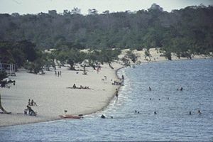
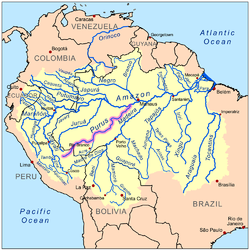
Purus
Encyclopedia
Tributary
A tributary or affluent is a stream or river that flows into a main stem river or a lake. A tributary does not flow directly into a sea or ocean...
of the Amazon River
Amazon River
The Amazon of South America is the second longest river in the world and by far the largest by waterflow with an average discharge greater than the next seven largest rivers combined...
in South America
South America
South America is a continent situated in the Western Hemisphere, mostly in the Southern Hemisphere, with a relatively small portion in the Northern Hemisphere. The continent is also considered a subcontinent of the Americas. It is bordered on the west by the Pacific Ocean and on the north and east...
. Its drainage basin
Drainage basin
A drainage basin is an extent or an area of land where surface water from rain and melting snow or ice converges to a single point, usually the exit of the basin, where the waters join another waterbody, such as a river, lake, reservoir, estuary, wetland, sea, or ocean...
is 63166 km² (24,389 sq mi), and the mean discharge
Discharge (hydrology)
In hydrology, discharge is the volume rate of water flow, including any suspended solids , dissolved chemical species and/or biologic material , which is transported through a given cross-sectional area...
is 8,400 m³/s.
It enters the Amazon River west of the Madeira River
Madeira River
The Madeira River is a major waterway in South America, approximately 3,250 km miles long The Madeira is the biggest tributary of the Amazon...
, which it parallels as far south as the falls of the latter stream. It runs through a continuous forest at the bottom of the great depression lying between the Madeira River
Madeira River
The Madeira River is a major waterway in South America, approximately 3,250 km miles long The Madeira is the biggest tributary of the Amazon...
, which skirts the edge of the Brazil
Brazil
Brazil , officially the Federative Republic of Brazil , is the largest country in South America. It is the world's fifth largest country, both by geographical area and by population with over 192 million people...
ian sandstone
Sandstone
Sandstone is a sedimentary rock composed mainly of sand-sized minerals or rock grains.Most sandstone is composed of quartz and/or feldspar because these are the most common minerals in the Earth's crust. Like sand, sandstone may be any colour, but the most common colours are tan, brown, yellow,...
plateau, and the Ucayali
Ucayali
The Ucayali River arises about north of Lake Titicaca, in the Arequipa region of South America. The Amazon River takes its name close to Nauta city , in the confluence among Ucayali and Marañón rivers....
which hugs the base of the Andes
Andes
The Andes is the world's longest continental mountain range. It is a continual range of highlands along the western coast of South America. This range is about long, about to wide , and of an average height of about .Along its length, the Andes is split into several ranges, which are separated...
. The river forms a small part of the international boundary between Brazil and Peru.
One of its marked features is the five parallel furos which from the north-west at almost regular intervals the Amazon sends to the Purus; the most south-westerly one being about 150 miles (240 km) above the mouth of the latter river. They cut a great area of very low-lying country into five islands. Farther down the Purus to the right three smaller furos also connect it with the Amazon.
William Chandless
William Chandless
William Chandless was a British explorer of the Amazon Basin in the 1860s. During this time he lived in Manaus from where he explored many of the Amazon River's southern tributaries and contacted various indigenous tribes...
found its elevation above sea-level to be only 107 feet (33 m) 590 miles (950 km) from its mouth. It is one of the most crooked streams in the world, and its length in a straight line is less than half that by its curves. It is practically only a drainage ditch for the half-submerged, lake-flooded district it traverses.
Its width is very uniform for 1000 miles (1600 km) up, and for 800 miles (1300 km) its depth is never less than 45 feet (15 m).
It is navigable by steamers for 1648 miles (2650 km) as far as the little stream, the Curumaha, but only by light-draft craft. Chandless ascended it 1866 miles (3,000 km). At 1792 miles (2,880 km) it forks into two small streams. Occasionally a cliff touches the river, but in general the lands are subject to yearly inundations throughout its course, the river rising at times above 50 feet (15 m), the numerous lakes to the right and left serving as reservoirs.
Its main tributary
Tributary
A tributary or affluent is a stream or river that flows into a main stem river or a lake. A tributary does not flow directly into a sea or ocean...
, the Aquiry or Acre River, enters from the right about 1104 miles (1777 km) from the Amazon. Its sources are near those of the Mayutata. It is navigable for a period of about five months of the year, when the Purus valley is inundated; and, for the remaining seven months, only canoes can ascend it sufficiently high to communicate overland with the settlements in the great India-rubber districts of the Mayutata and lower Beni
Beni
Beni may refer to:Places*Beni Department, Beni River and the Beni savanna, Bolivia*Beni Suef and Beni Hasan, Egypt*Beni Mellal and Beni Amir, Morocco*Beni, Nord-Kivu, Democratic Republic of the Congo*Beni, Nepal Culture...
; thus these regions are forced to seek a canoe outlet for their rich products by the very dangerous, costly and laborious route of the falls of the Madeira River
Madeira River
The Madeira River is a major waterway in South America, approximately 3,250 km miles long The Madeira is the biggest tributary of the Amazon...
.
In 2008 a previously unknown precolumbian civilization was discovered in the upper region of the river close to the Bolivian border. After much of the forest in the region was cleared for agricultural use, satellite pictures revealed the remains of large geometric earthworks.
External links
- Map of Amazon Sate with Purus River- Brazilian Ministry of Transport