
1980 Atlantic hurricane season
Encyclopedia
The 1980 Atlantic hurricane season officially began on June 1, 1980, and lasted until November 30, 1980. These dates conventionally delimit the period of each year when most tropical cyclone
s form in the Atlantic basin
. The season
was fairly active, with eleven storms forming, of which nine reached hurricane strength.
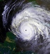
Only three storms made landfall in the 1980 season. The most notable storm was Hurricane Allen
, a powerful Category 5 hurricane
that travelled across the Caribbean
and the Gulf of Mexico
, causing widespread damage and hundreds of deaths. Additionally, Tropical Storm Danielle flooded the northeast coast of Texas
, and Tropical Storm Hermine was responsible for flooding in Mexico
.
(ACE) rating of 149, which is classified as "above normal". ACE is, broadly speaking, a measure of the power of the hurricane multiplied by the length of time it existed, so storms that last a long time, as well as particularly strong hurricanes, have high ACEs. ACE is only calculated for full advisories on tropical systems at or exceeding 34 knots (39 mph, 63 km/h) or tropical storm strength. Subtropical cyclone
s are excluded from the total.
and the Yucatan Peninsula
. The depression moved northwestward, and minimal intensification occurred, as it approached the Gulf Coast of the United States
. The depression made landfall in Texas near the Galveston area, and dissipated by July 21. Minimal impact was recorded from the depression, and light rainfall was reported in Texas and western Louisiana, peaking at 3.77 in (95.8 mm) in Refugio, Texas
.
that moved off the coast of Africa
. A tropical wave became Tropical Depression Two late on August 1. Tropical Depression Two became Tropical Storm Allen on August 2, and on the 3rd moved between Barbados
and St. Lucia as a hurricane. Now in the Caribbean Sea
, the storm passed just south of Hispaniola
, then continued west between Cuba
and Jamaica
.
Allen stayed south of Cuba, and passed through the Yucatan Channel
into the Gulf of Mexico
. The center of Hurricane Allen finally struck land in southern Texas
near the border with Mexico
. Allen underwent a rapid drop in intensity just before its only landfall, described by a National Weather Service
statement as "miraculous".
Allen was one of the strongest Atlantic hurricanes of record, with maximum sustained winds at 190 mi/h at its peak. It became a Category 5 on the Saffir-Simpson Hurricane Scale
on August 5; Allen reached that strength two more times thereafter. While the storm was passing south of Cuba, its wind field extended so far as to cause gale force winds to be recorded in the Florida Keys
on the far side of Cuba.
Allen killed roughly 250 people, mostly in Haiti
. Property damage was estimated at over $1 billion (1980 US dollars), mostly to the U.S. and Haiti.
.
and the Windward Islands
on August 14. The storm moved almost due north, strengthening into a hurricane. A companion tropical system formed near Bonnie, but never exceeded depression strength. Bonnie continued north until it became extratropical
on August 19. Hurricane Bonnie caused no known damage.
on August 20. As it moved over the ocean, its circulation closed, and it took on subtropical
characteristics. The storm followed a looping path generally to the east. On August 23, it reached hurricane strength and began moving almost due east. Charley weakened and was absorbed by an extratropical cyclone on August 26 without ever affecting land.
. The depression curved northwest and dissipated on August 29 before being able to affect land.
on September 4. As it moved west, it strengthened, reaching tropical storm intensity on September 5 while just south of Cameron, Louisiana
. It struck land near Galveston, Texas
a few hours later. Danielle weakened over land, but its circulation was tracked as far inland as Del Rio, Texas
.
Wind and wave damage from Danielle was minimal. However, heavy rainfall caused flooding in the Beaumont
– Port Arthur
area of Texas
. The Jefferson County Airport
recorded 17.16 inches (436 mm) of rain, setting a new 24-hour record for that location. The storm total maximum at that location totaled 18.29 inches (464.6 mm), which was the highest observed with Danielle.
s to form in early September. Earl was named on September 6, although re-analysis showed that it actually reached tropical storm strength on September 6. The storm followed a curving path roughly centered on the Azores. It reached hurricane strength on September 8 before weakening and becoming extratropical on September 10. Earl caused no reported damage to land or shipping.
n coast on September 5, and developed into Tropical Depression Ten on the following day. Later that day, the depression intensified into Tropical Storm Frances. After becoming a tropical storm, Frances rapidly strengthened, reaching hurricane intensity by September 7. Frances moved slowly to the west, reaching its peak intensity of as a Category 3 hurricane with maximum sustained winds of 115 mph (185 km/h). After peak intensity, Frances weakened back below major hurricane intensity, but oscillated in intensity, ranging from a Category 2 hurricane to a Category 1 hurricane over the next few days. However, by September 17, Frances had weakened back into a Category 1 hurricane, and re-intensification would not occur. It then turned northeast and was absorbed by another low pressure system over the north Atlantic on September 20.
Reports of strong tropical storm force winds were received from ships, but no damage was reported except for minor squalls in Cape Verde
.
, Georges lost its tropical characteristics over cold water. Georges caused no known damage.
n tropical wave
that traversed the Atlantic Ocean
organized into a tropical storm off the coast of Honduras
on September 21. After grazing Honduras, a disorganized Tropical Storm Hermine made landfall just north of Belize City
on the 22nd. After crossing the Yucatán Peninsula
, Hermine briefly emerged over the Bay of Campeche
where it restrengthened before recurving back into the Mexican
coast. The storm drifted inland and its surface dissipated on September 26. The remnant disturbance tracked around the southern and western periphery of Mexico over the next few days.
Hermine caused freshwater flooding in Mexico. Storm total rainfall across Mexico reached as high as 31.15 inches (791.2 mm) at San Pedro Tapanatepec. No reports on Honduras and Belize
were received by the NHC, but meteorologists stated that similar flooding likely occurred there as well.
low
persisted off the coast of Portugal
, moving southwestward. At the time, there was little convection near the center, although the overall cloud pattern cyclonically curved. The system gradually developed tropical characteristics
as it turned northwestward and executed a loop near the Azores. After the cyclone resumed its southwest track, the convection increased and became more organized near the center. Even though it was located beneath an upper-level low, it was sufficiently organized to be designated a tropical depression on October 4 just east of the Azores; shortly thereafter, it intensified into Tropical Storm Ivan. The National Hurricane Center
did not initiate advisories on Ivan until late on October 5, by which time the storm was strengthening and developing anticyclonic outflow aloft. Ivan moved largely in tandem with the upper-level low above it, while its southwest movement was caused by a building ridge
to its north. Late on October 5, an eye
developed, and by October 6 Ivan attained hurricane status about 600 miles (970 km) southwest of the Azores. It slowed down as the ridge to its north weakened, and 18 hours after reaching hurricane strength, Ivan peaked with winds of 105 mph (165 km/h).
Between October 6 and the 7, Hurricane Ivan executed a tight loop, after which another ridge began intensifying to its east; this allowed the storm to begin a motion to the west-northwest. Ultimately, the intensity did not change for about 90 hours. During that time, the eye fluctuated occasionally as the convection waxed and waned. On October 9, Ivan turned to the north in advance of an approaching cold front
and extratropical storm. The next day, the hurricane began weakening as it accelerated northeastward over cooler waters of the far northern Atlantic Ocean. By October 12, the cold front absorbed Hurricane Ivan when it was located about 665 miles (1070 km) west of Ireland
. Ivan only posed a threat to shipping interests, and several vessels recorded gale-force winds.
, and the first recorded to have reached hurricane status while already in the Gulf. Jeanne began as a tropical depression near the coast of Nicaragua
on November 8. The depression reached tropical storm strength the next day as it moved through the Yucatan Channel
. Jeanne turned westward over the central Gulf, and strengthened into a hurricane. As the hurricane entered the western Gulf, it weakened to a tropical storm. It meandered for several days until a cold front moving off the Texas
coast destroyed the storm's circulation. The systems merged on November 16.
Damage was limited to shipping, which was caught by surprise by the late-season storm. Fringe effects of Hurricane Jeanne triggered a record-breaking 23.28 inches (591 mm) of rain at Key West, Florida
within a 24-hour period.
November 12. Steered northward by deep southerly flow southeast of Jeanne, the tropical depression varied in organization through much of its life cyclone. Briefly, the cloud pattern between Jeanne and the depression merged, with a line of thunderstorms moving across the Florida peninsula between the two systems as the depression underwent increased westerly vertical wind shear. By November 15, the depression regained convective organization as it moved ashore western Cuba early on November 16. By early on November 17, vertical wind shear increased from the northwest, and the center parted from the system's related thunderstorm activity once more. After the system moved through the Florida peninsula, thunderstorms increased near the system once more as it pulled northeast offshore the Southeast United States.
. It was the first use for all of these names since the post-1978 naming change, except Frances which was used in 1961, 1968, and 1976. Names that were not assigned are marked in .
retired one name in the spring of 1981: Allen. It was replaced in 1986 season
by Andrew.
Tropical cyclone
A tropical cyclone is a storm system characterized by a large low-pressure center and numerous thunderstorms that produce strong winds and heavy rain. Tropical cyclones strengthen when water evaporated from the ocean is released as the saturated air rises, resulting in condensation of water vapor...
s form in the Atlantic basin
Atlantic Basin
The Atlantic Basin is the Atlantic Ocean.Atlantic Basin may also refer to:* Atlantic Basin Iron Works, an ironworks that operated in Brooklyn, New York, in the early to mid-20th century...
. The season
Atlantic hurricane season
The Atlantic hurricane season is the period in a year when hurricanes usually form in the Atlantic Ocean. Tropical cyclones in the North Atlantic are called hurricanes, tropical storms, or tropical depressions. In addition, there have been several storms over the years that have not been fully...
was fairly active, with eleven storms forming, of which nine reached hurricane strength.
Only three storms made landfall in the 1980 season. The most notable storm was Hurricane Allen
Hurricane Allen
Hurricane Allen was the first and strongest hurricane of the 1980 Atlantic hurricane season. It was one of the strongest hurricanes in recorded history, one of the few hurricanes to reach Category 5 status on the Saffir-Simpson Hurricane Scale on three separate occasions, and spent more time...
, a powerful Category 5 hurricane
Saffir-Simpson Hurricane Scale
The Saffir–Simpson Hurricane Scale , or the Saffir–Simpson Hurricane Wind Scale , classifies hurricanes — Western Hemisphere tropical cyclones that exceed the intensities of tropical depressions and tropical storms — into five categories distinguished by the intensities of their sustained winds...
that travelled across the Caribbean
Caribbean
The Caribbean is a crescent-shaped group of islands more than 2,000 miles long separating the Gulf of Mexico and the Caribbean Sea, to the west and south, from the Atlantic Ocean, to the east and north...
and the Gulf of Mexico
Gulf of Mexico
The Gulf of Mexico is a partially landlocked ocean basin largely surrounded by the North American continent and the island of Cuba. It is bounded on the northeast, north and northwest by the Gulf Coast of the United States, on the southwest and south by Mexico, and on the southeast by Cuba. In...
, causing widespread damage and hundreds of deaths. Additionally, Tropical Storm Danielle flooded the northeast coast of Texas
Texas
Texas is the second largest U.S. state by both area and population, and the largest state by area in the contiguous United States.The name, based on the Caddo word "Tejas" meaning "friends" or "allies", was applied by the Spanish to the Caddo themselves and to the region of their settlement in...
, and Tropical Storm Hermine was responsible for flooding in Mexico
Mexico
The United Mexican States , commonly known as Mexico , is a federal constitutional republic in North America. It is bordered on the north by the United States; on the south and west by the Pacific Ocean; on the southeast by Guatemala, Belize, and the Caribbean Sea; and on the east by the Gulf of...
.
Season summary
The season's activity was reflected with a cumulative accumulated cyclone energyAccumulated cyclone energy
Accumulated cyclone energy is a measure used by the National Oceanic and Atmospheric Administration to express the activity of individual tropical cyclones and entire tropical cyclone seasons, particularly the North Atlantic hurricane season. It uses an approximation of the energy used by a...
(ACE) rating of 149, which is classified as "above normal". ACE is, broadly speaking, a measure of the power of the hurricane multiplied by the length of time it existed, so storms that last a long time, as well as particularly strong hurricanes, have high ACEs. ACE is only calculated for full advisories on tropical systems at or exceeding 34 knots (39 mph, 63 km/h) or tropical storm strength. Subtropical cyclone
Subtropical cyclone
A subtropical cyclone is a weather system that has some characteristics of a tropical and an extratropical cyclone. As early as the 1950s, meteorologists were unclear whether they should be characterized as tropical or extratropical cyclones. They were officially recognized by the National...
s are excluded from the total.
Tropical Depression One
A decaying cold front entered into Gulf of Mexico, and developed a low-pressure area of July 17. Later that day, the low-pressure area developed into Tropical Depression One almost halfway between LouisianaLouisiana
Louisiana is a state located in the southern region of the United States of America. Its capital is Baton Rouge and largest city is New Orleans. Louisiana is the only state in the U.S. with political subdivisions termed parishes, which are local governments equivalent to counties...
and the Yucatan Peninsula
Yucatán Peninsula
The Yucatán Peninsula, in southeastern Mexico, separates the Caribbean Sea from the Gulf of Mexico, with the northern coastline on the Yucatán Channel...
. The depression moved northwestward, and minimal intensification occurred, as it approached the Gulf Coast of the United States
Gulf Coast of the United States
The Gulf Coast of the United States, sometimes referred to as the Gulf South, South Coast, or 3rd Coast, comprises the coasts of American states that are on the Gulf of Mexico, which includes Texas, Louisiana, Mississippi, Alabama, and Florida and are known as the Gulf States...
. The depression made landfall in Texas near the Galveston area, and dissipated by July 21. Minimal impact was recorded from the depression, and light rainfall was reported in Texas and western Louisiana, peaking at 3.77 in (95.8 mm) in Refugio, Texas
Refugio, Texas
Refugio is a town in Refugio County, Texas, United States. The population was 2,941 at the 2000 census. It is the county seat of Refugio County. Although the town's name is derived from Spanish, a vast majority of the town's residents pronounce it re-fury-oh. The Spanish pronunciation is...
.
Hurricane Allen
Like most Atlantic hurricanes, Allen originated as a tropical waveTropical wave
Tropical waves, easterly waves, or tropical easterly waves, also known as African easterly waves in the Atlantic region, are a type of atmospheric trough, an elongated area of relatively low air pressure, oriented north to south, which move from east to west across the tropics causing areas of...
that moved off the coast of Africa
Africa
Africa is the world's second largest and second most populous continent, after Asia. At about 30.2 million km² including adjacent islands, it covers 6% of the Earth's total surface area and 20.4% of the total land area...
. A tropical wave became Tropical Depression Two late on August 1. Tropical Depression Two became Tropical Storm Allen on August 2, and on the 3rd moved between Barbados
Barbados
Barbados is an island country in the Lesser Antilles. It is in length and as much as in width, amounting to . It is situated in the western area of the North Atlantic and 100 kilometres east of the Windward Islands and the Caribbean Sea; therein, it is about east of the islands of Saint...
and St. Lucia as a hurricane. Now in the Caribbean Sea
Caribbean Sea
The Caribbean Sea is a sea of the Atlantic Ocean located in the tropics of the Western hemisphere. It is bounded by Mexico and Central America to the west and southwest, to the north by the Greater Antilles, and to the east by the Lesser Antilles....
, the storm passed just south of Hispaniola
Hispaniola
Hispaniola is a major island in the Caribbean, containing the two sovereign states of the Dominican Republic and Haiti. The island is located between the islands of Cuba to the west and Puerto Rico to the east, within the hurricane belt...
, then continued west between Cuba
Cuba
The Republic of Cuba is an island nation in the Caribbean. The nation of Cuba consists of the main island of Cuba, the Isla de la Juventud, and several archipelagos. Havana is the largest city in Cuba and the country's capital. Santiago de Cuba is the second largest city...
and Jamaica
Jamaica
Jamaica is an island nation of the Greater Antilles, in length, up to in width and 10,990 square kilometres in area. It is situated in the Caribbean Sea, about south of Cuba, and west of Hispaniola, the island harbouring the nation-states Haiti and the Dominican Republic...
.
Allen stayed south of Cuba, and passed through the Yucatan Channel
Yucatán Channel
The Yucatán Channel is a strait between Mexico and Cuba. It connects the Yucatán Basin of the Caribbean Sea with the Gulf of Mexico. The strait is across between Cape Catoche in Mexico and Cape San Antonio, Cuba and reaches a maximum depth of .-References:...
into the Gulf of Mexico
Gulf of Mexico
The Gulf of Mexico is a partially landlocked ocean basin largely surrounded by the North American continent and the island of Cuba. It is bounded on the northeast, north and northwest by the Gulf Coast of the United States, on the southwest and south by Mexico, and on the southeast by Cuba. In...
. The center of Hurricane Allen finally struck land in southern Texas
Texas
Texas is the second largest U.S. state by both area and population, and the largest state by area in the contiguous United States.The name, based on the Caddo word "Tejas" meaning "friends" or "allies", was applied by the Spanish to the Caddo themselves and to the region of their settlement in...
near the border with Mexico
Mexico
The United Mexican States , commonly known as Mexico , is a federal constitutional republic in North America. It is bordered on the north by the United States; on the south and west by the Pacific Ocean; on the southeast by Guatemala, Belize, and the Caribbean Sea; and on the east by the Gulf of...
. Allen underwent a rapid drop in intensity just before its only landfall, described by a National Weather Service
National Weather Service
The National Weather Service , once known as the Weather Bureau, is one of the six scientific agencies that make up the National Oceanic and Atmospheric Administration of the United States government...
statement as "miraculous".
Allen was one of the strongest Atlantic hurricanes of record, with maximum sustained winds at 190 mi/h at its peak. It became a Category 5 on the Saffir-Simpson Hurricane Scale
Saffir-Simpson Hurricane Scale
The Saffir–Simpson Hurricane Scale , or the Saffir–Simpson Hurricane Wind Scale , classifies hurricanes — Western Hemisphere tropical cyclones that exceed the intensities of tropical depressions and tropical storms — into five categories distinguished by the intensities of their sustained winds...
on August 5; Allen reached that strength two more times thereafter. While the storm was passing south of Cuba, its wind field extended so far as to cause gale force winds to be recorded in the Florida Keys
Florida Keys
The Florida Keys are a coral archipelago in southeast United States. They begin at the southeastern tip of the Florida peninsula, about south of Miami, and extend in a gentle arc south-southwest and then westward to Key West, the westernmost of the inhabited islands, and on to the uninhabited Dry...
on the far side of Cuba.
Allen killed roughly 250 people, mostly in Haiti
Haiti
Haiti , officially the Republic of Haiti , is a Caribbean country. It occupies the western, smaller portion of the island of Hispaniola, in the Greater Antillean archipelago, which it shares with the Dominican Republic. Ayiti was the indigenous Taíno or Amerindian name for the island...
. Property damage was estimated at over $1 billion (1980 US dollars), mostly to the U.S. and Haiti.
Tropical Depression Four
Tropical Depression Four formed on August 13 just east of Cape Verde. Tropical Depression Four moved through the islands shortly later. Tropical Depression Four dissipated on August 16 near the AzoresAzores
The Archipelago of the Azores is composed of nine volcanic islands situated in the middle of the North Atlantic Ocean, and is located about west from Lisbon and about east from the east coast of North America. The islands, and their economic exclusion zone, form the Autonomous Region of the...
.
Hurricane Bonnie
Bonnie formed midway between Cape VerdeCape Verde
The Republic of Cape Verde is an island country, spanning an archipelago of 10 islands located in the central Atlantic Ocean, 570 kilometres off the coast of Western Africa...
and the Windward Islands
Windward Islands
The Windward Islands are the southern islands of the Lesser Antilles, within the West Indies.-Name and geography:The Windward Islands are called such because they were more windward to sailing ships arriving in the New World than the Leeward Islands, given that the prevailing trade winds in the...
on August 14. The storm moved almost due north, strengthening into a hurricane. A companion tropical system formed near Bonnie, but never exceeded depression strength. Bonnie continued north until it became extratropical
Extratropical cyclone
Extratropical cyclones, sometimes called mid-latitude cyclones or wave cyclones, are a group of cyclones defined as synoptic scale low pressure weather systems that occur in the middle latitudes of the Earth having neither tropical nor polar characteristics, and are connected with fronts and...
on August 19. Hurricane Bonnie caused no known damage.
Hurricane Charley
An extratropical storm moved off the Atlantic coast of the United StatesUnited States
The United States of America is a federal constitutional republic comprising fifty states and a federal district...
on August 20. As it moved over the ocean, its circulation closed, and it took on subtropical
Subtropical cyclone
A subtropical cyclone is a weather system that has some characteristics of a tropical and an extratropical cyclone. As early as the 1950s, meteorologists were unclear whether they should be characterized as tropical or extratropical cyclones. They were officially recognized by the National...
characteristics. The storm followed a looping path generally to the east. On August 23, it reached hurricane strength and began moving almost due east. Charley weakened and was absorbed by an extratropical cyclone on August 26 without ever affecting land.
Tropical Depression Six
Tropical Depression Six formed on August 25. The depression headed west towards the Lesser AntillesLesser Antilles
The Lesser Antilles are a long, partly volcanic island arc in the Western Hemisphere. Most of its islands form the eastern boundary of the Caribbean Sea with the Atlantic Ocean, with the remainder located in the southern Caribbean just north of South America...
. The depression curved northwest and dissipated on August 29 before being able to affect land.
Tropical Storm Danielle
Danielle formed as a tropical depression off the coast of LouisianaLouisiana
Louisiana is a state located in the southern region of the United States of America. Its capital is Baton Rouge and largest city is New Orleans. Louisiana is the only state in the U.S. with political subdivisions termed parishes, which are local governments equivalent to counties...
on September 4. As it moved west, it strengthened, reaching tropical storm intensity on September 5 while just south of Cameron, Louisiana
Cameron, Louisiana
Cameron is a census-designated place in and the parish seat of Cameron Parish, Louisiana, United States. The population was 1,965 at the 2000 census. It is part of the Lake Charles Metropolitan Statistical Area...
. It struck land near Galveston, Texas
Galveston, Texas
Galveston is a coastal city located on Galveston Island in the U.S. state of Texas. , the city had a total population of 47,743 within an area of...
a few hours later. Danielle weakened over land, but its circulation was tracked as far inland as Del Rio, Texas
Del Rio, Texas
Del Rio is a border city in and the county seat of Val Verde County, Texas, United States.. Del Rio is connected with Ciudad Acuña via the Lake Amistad Dam International Crossing and Del Río-Ciudad Acuña International Bridge...
.
Wind and wave damage from Danielle was minimal. However, heavy rainfall caused flooding in the Beaumont
Beaumont, Texas
Beaumont is a city in and county seat of Jefferson County, Texas, United States, within the Beaumont–Port Arthur Metropolitan Statistical Area. The city's population was 118,296 at the 2010 census. With Port Arthur and Orange, it forms the Golden Triangle, a major industrial area on the...
– Port Arthur
Port Arthur, Texas
-Demographics:As of the 2000 census, there were 57,755 people, 21,839 households, and 14,675 families residing in the city. The population density was 696.5 people per square mile . There were 24,713 housing units at an average density of 298.0 per square mile...
area of Texas
Texas
Texas is the second largest U.S. state by both area and population, and the largest state by area in the contiguous United States.The name, based on the Caddo word "Tejas" meaning "friends" or "allies", was applied by the Spanish to the Caddo themselves and to the region of their settlement in...
. The Jefferson County Airport
Southeast Texas Regional Airport
Jack Brooks Regional Airport , is a public airport located near Port Arthur, Texas, United States, nine miles southeast of the central business district of Beaumont and northeast of Port Arthur...
recorded 17.16 inches (436 mm) of rain, setting a new 24-hour record for that location. The storm total maximum at that location totaled 18.29 inches (464.6 mm), which was the highest observed with Danielle.
Hurricane Earl
Hurricane Earl was the first of a short series of Cape Verde-type hurricaneCape Verde-type hurricane
A Cape Verde-type hurricane is an Atlantic hurricane that develops near the Cape Verde islands, off the west coast of Africa. The average hurricane season has about two Cape Verde-type hurricanes, which are usually the largest and most intense storms of the season because they often have plenty of...
s to form in early September. Earl was named on September 6, although re-analysis showed that it actually reached tropical storm strength on September 6. The storm followed a curving path roughly centered on the Azores. It reached hurricane strength on September 8 before weakening and becoming extratropical on September 10. Earl caused no reported damage to land or shipping.
Hurricane Frances
A strong low pressure system moved off the AfricaAfrica
Africa is the world's second largest and second most populous continent, after Asia. At about 30.2 million km² including adjacent islands, it covers 6% of the Earth's total surface area and 20.4% of the total land area...
n coast on September 5, and developed into Tropical Depression Ten on the following day. Later that day, the depression intensified into Tropical Storm Frances. After becoming a tropical storm, Frances rapidly strengthened, reaching hurricane intensity by September 7. Frances moved slowly to the west, reaching its peak intensity of as a Category 3 hurricane with maximum sustained winds of 115 mph (185 km/h). After peak intensity, Frances weakened back below major hurricane intensity, but oscillated in intensity, ranging from a Category 2 hurricane to a Category 1 hurricane over the next few days. However, by September 17, Frances had weakened back into a Category 1 hurricane, and re-intensification would not occur. It then turned northeast and was absorbed by another low pressure system over the north Atlantic on September 20.
Reports of strong tropical storm force winds were received from ships, but no damage was reported except for minor squalls in Cape Verde
Cape Verde
The Republic of Cape Verde is an island country, spanning an archipelago of 10 islands located in the central Atlantic Ocean, 570 kilometres off the coast of Western Africa...
.
Hurricane Georges
Georges initially formed as a tropical depression over the central Atlantic on September 1. This depression remained weak for the next several days as it travelled west-northwest. Interaction with a non-tropical low disrupted the depression and destroyed its circulation. On September 5, a subtropical system began forming out of the depression's remnants as they began turning to the northeast. The subtropical depression strengthened and became tropical, finally becoming a named storm on September 7 as it passed north of Bermuda. The tropical storm intensified into a hurricane, one of few to do so north of 40°N. After passing Cape RaceCape Race
Cape Race is a point of land located at the southeastern tip of the Avalon Peninsula on the island of Newfoundland, Canada. Its name is thought to come from the original Portuguese name for this cape, "Raso", or "bare"...
, Georges lost its tropical characteristics over cold water. Georges caused no known damage.
Tropical Storm Hermine
An AfricaAfrica
Africa is the world's second largest and second most populous continent, after Asia. At about 30.2 million km² including adjacent islands, it covers 6% of the Earth's total surface area and 20.4% of the total land area...
n tropical wave
Tropical wave
Tropical waves, easterly waves, or tropical easterly waves, also known as African easterly waves in the Atlantic region, are a type of atmospheric trough, an elongated area of relatively low air pressure, oriented north to south, which move from east to west across the tropics causing areas of...
that traversed the Atlantic Ocean
Atlantic Ocean
The Atlantic Ocean is the second-largest of the world's oceanic divisions. With a total area of about , it covers approximately 20% of the Earth's surface and about 26% of its water surface area...
organized into a tropical storm off the coast of Honduras
Honduras
Honduras is a republic in Central America. It was previously known as Spanish Honduras to differentiate it from British Honduras, which became the modern-day state of Belize...
on September 21. After grazing Honduras, a disorganized Tropical Storm Hermine made landfall just north of Belize City
Belize City
Belize City is the largest city in the Central American nation of Belize. Unofficial estimates place the population of Belize City at 70,000 or more. It is located at the mouth of the Belize River on the coast of the Caribbean. The city is the country's principal port and its financial and...
on the 22nd. After crossing the Yucatán Peninsula
Yucatán Peninsula
The Yucatán Peninsula, in southeastern Mexico, separates the Caribbean Sea from the Gulf of Mexico, with the northern coastline on the Yucatán Channel...
, Hermine briefly emerged over the Bay of Campeche
Bay of Campeche
The Bay of Campeche is the southern bight of the Gulf of Mexico. It is surrounded on three sides by the Mexican states of Campeche, Tabasco and Veracruz. It was named by Francisco Hernández de Córdoba and Antonio de Alaminos during their expedition in 1517...
where it restrengthened before recurving back into the Mexican
Mexico
The United Mexican States , commonly known as Mexico , is a federal constitutional republic in North America. It is bordered on the north by the United States; on the south and west by the Pacific Ocean; on the southeast by Guatemala, Belize, and the Caribbean Sea; and on the east by the Gulf of...
coast. The storm drifted inland and its surface dissipated on September 26. The remnant disturbance tracked around the southern and western periphery of Mexico over the next few days.
Hermine caused freshwater flooding in Mexico. Storm total rainfall across Mexico reached as high as 31.15 inches (791.2 mm) at San Pedro Tapanatepec. No reports on Honduras and Belize
Belize
Belize is a constitutional monarchy and the northernmost country in Central America. Belize has a diverse society, comprising many cultures and languages. Even though Kriol and Spanish are spoken among the population, Belize is the only country in Central America where English is the official...
were received by the NHC, but meteorologists stated that similar flooding likely occurred there as well.
Hurricane Ivan
In late September, an cold-coreExtratropical cyclone
Extratropical cyclones, sometimes called mid-latitude cyclones or wave cyclones, are a group of cyclones defined as synoptic scale low pressure weather systems that occur in the middle latitudes of the Earth having neither tropical nor polar characteristics, and are connected with fronts and...
low
Low pressure area
A low-pressure area, or "low", is a region where the atmospheric pressure at sea level is below that of surrounding locations. Low-pressure systems form under areas of wind divergence which occur in upper levels of the troposphere. The formation process of a low-pressure area is known as...
persisted off the coast of Portugal
Portugal
Portugal , officially the Portuguese Republic is a country situated in southwestern Europe on the Iberian Peninsula. Portugal is the westernmost country of Europe, and is bordered by the Atlantic Ocean to the West and South and by Spain to the North and East. The Atlantic archipelagos of the...
, moving southwestward. At the time, there was little convection near the center, although the overall cloud pattern cyclonically curved. The system gradually developed tropical characteristics
Tropical cyclogenesis
Tropical cyclogenesis is the term that describes the development and strengthening of a tropical cyclone in the atmosphere. The mechanisms through which tropical cyclogenesis occurs are distinctly different from those through which mid-latitude cyclogenesis occurs...
as it turned northwestward and executed a loop near the Azores. After the cyclone resumed its southwest track, the convection increased and became more organized near the center. Even though it was located beneath an upper-level low, it was sufficiently organized to be designated a tropical depression on October 4 just east of the Azores; shortly thereafter, it intensified into Tropical Storm Ivan. The National Hurricane Center
National Hurricane Center
The National Hurricane Center , located at Florida International University in Miami, Florida, is the division of the National Weather Service responsible for tracking and predicting weather systems within the tropics between the Prime Meridian and the 140th meridian west poleward to the 30th...
did not initiate advisories on Ivan until late on October 5, by which time the storm was strengthening and developing anticyclonic outflow aloft. Ivan moved largely in tandem with the upper-level low above it, while its southwest movement was caused by a building ridge
Ridge (meteorology)
A ridge is an elongated region of relatively high atmospheric pressure, the opposite of a trough....
to its north. Late on October 5, an eye
Eye (cyclone)
The eye is a region of mostly calm weather found at the center of strong tropical cyclones. The eye of a storm is a roughly circular area and typically 30–65 km in diameter. It is surrounded by the eyewall, a ring of towering thunderstorms where the second most severe weather of a cyclone...
developed, and by October 6 Ivan attained hurricane status about 600 miles (970 km) southwest of the Azores. It slowed down as the ridge to its north weakened, and 18 hours after reaching hurricane strength, Ivan peaked with winds of 105 mph (165 km/h).
Between October 6 and the 7, Hurricane Ivan executed a tight loop, after which another ridge began intensifying to its east; this allowed the storm to begin a motion to the west-northwest. Ultimately, the intensity did not change for about 90 hours. During that time, the eye fluctuated occasionally as the convection waxed and waned. On October 9, Ivan turned to the north in advance of an approaching cold front
Cold front
A cold front is defined as the leading edge of a cooler mass of air, replacing a warmer mass of air.-Development of cold front:The cooler and denser air wedges under the less-dense warmer air, lifting it...
and extratropical storm. The next day, the hurricane began weakening as it accelerated northeastward over cooler waters of the far northern Atlantic Ocean. By October 12, the cold front absorbed Hurricane Ivan when it was located about 665 miles (1070 km) west of Ireland
Ireland
Ireland is an island to the northwest of continental Europe. It is the third-largest island in Europe and the twentieth-largest island on Earth...
. Ivan only posed a threat to shipping interests, and several vessels recorded gale-force winds.
Hurricane Jeanne
Jeanne was another unusual storm, becoming one of a handful of November hurricanes in the Gulf of MexicoGulf of Mexico
The Gulf of Mexico is a partially landlocked ocean basin largely surrounded by the North American continent and the island of Cuba. It is bounded on the northeast, north and northwest by the Gulf Coast of the United States, on the southwest and south by Mexico, and on the southeast by Cuba. In...
, and the first recorded to have reached hurricane status while already in the Gulf. Jeanne began as a tropical depression near the coast of Nicaragua
Nicaragua
Nicaragua is the largest country in the Central American American isthmus, bordered by Honduras to the north and Costa Rica to the south. The country is situated between 11 and 14 degrees north of the Equator in the Northern Hemisphere, which places it entirely within the tropics. The Pacific Ocean...
on November 8. The depression reached tropical storm strength the next day as it moved through the Yucatan Channel
Yucatán Channel
The Yucatán Channel is a strait between Mexico and Cuba. It connects the Yucatán Basin of the Caribbean Sea with the Gulf of Mexico. The strait is across between Cape Catoche in Mexico and Cape San Antonio, Cuba and reaches a maximum depth of .-References:...
. Jeanne turned westward over the central Gulf, and strengthened into a hurricane. As the hurricane entered the western Gulf, it weakened to a tropical storm. It meandered for several days until a cold front moving off the Texas
Texas
Texas is the second largest U.S. state by both area and population, and the largest state by area in the contiguous United States.The name, based on the Caddo word "Tejas" meaning "friends" or "allies", was applied by the Spanish to the Caddo themselves and to the region of their settlement in...
coast destroyed the storm's circulation. The systems merged on November 16.
Damage was limited to shipping, which was caught by surprise by the late-season storm. Fringe effects of Hurricane Jeanne triggered a record-breaking 23.28 inches (591 mm) of rain at Key West, Florida
Key West, Florida
Key West is a city in Monroe County, Florida, United States. The city encompasses the island of Key West, the part of Stock Island north of U.S. 1 , Sigsbee Park , Fleming Key , and Sunset Key...
within a 24-hour period.
Tropical Depression Fourteen
As Jeanne meandered through the Gulf of Mexico, a tropical depression formed north of Panama onNovember 12. Steered northward by deep southerly flow southeast of Jeanne, the tropical depression varied in organization through much of its life cyclone. Briefly, the cloud pattern between Jeanne and the depression merged, with a line of thunderstorms moving across the Florida peninsula between the two systems as the depression underwent increased westerly vertical wind shear. By November 15, the depression regained convective organization as it moved ashore western Cuba early on November 16. By early on November 17, vertical wind shear increased from the northwest, and the center parted from the system's related thunderstorm activity once more. After the system moved through the Florida peninsula, thunderstorms increased near the system once more as it pulled northeast offshore the Southeast United States.
Hurricane Karl
A large extratropical low formed off the southeastern coast of the United States on November 21. The low moved away from the coast, and a convective cloud mass began forming near the low's center. By November 25, the cloud mass showed distinct signs of being a tropical system, and when its intensity was estimated at hurricane strength, it was classified as Hurricane Karl. Karl followed a curving cyclonic path, first east, then north. It approached the Azores on November 27, but did not approach close enough to affect the islands. By November 28, Hurricane Karl had become extratropical. No damage is associated with the storm.Storm names
The following names were used for named storms that formed in the north Atlantic in 1980. The names not retired from this list were used again in the 1986 season1986 Atlantic hurricane season
The 1986 Atlantic hurricane season officially began on June 1, 1986, and lasted until November 30, 1986. These dates conventionally delimit the period of each year when most tropical cyclones form in the Atlantic basin...
. It was the first use for all of these names since the post-1978 naming change, except Frances which was used in 1961, 1968, and 1976. Names that were not assigned are marked in .
|
Tropical Storm Hermine (1980) Tropical Storm Hermine was the eleventh tropical cyclone as well as the eight named storm of the 1980 Atlantic hurricane season. Hermine developed from a tropical wave which moved off the coast of Africa on September 11. It began to cross the Caribbean over the next several days, thought a there... Hurricane Jeanne (1980) Hurricane Jeanne was a moderate hurricane that formed and dissipated in the Gulf of Mexico without making landfall. The tenth tropical cyclone and eighth hurricane of the 1980 Atlantic hurricane season, Jeanne developed over the southern Caribbean on November 7. It moved swiftly northward, and it... Hurricane Karl (1980) Hurricane Karl was a late-season and unusual tropical cyclone that formed during the 1980 Atlantic hurricane season. A minimal Category 1 hurricane on the Saffir–Simpson Hurricane Scale, Karl developed at the center of another, larger extratropical cyclone over the North Atlantic... |
Retirement
The World Meteorological OrganizationWorld Meteorological Organization
The World Meteorological Organization is an intergovernmental organization with a membership of 189 Member States and Territories. It originated from the International Meteorological Organization , which was founded in 1873...
retired one name in the spring of 1981: Allen. It was replaced in 1986 season
1986 Atlantic hurricane season
The 1986 Atlantic hurricane season officially began on June 1, 1986, and lasted until November 30, 1986. These dates conventionally delimit the period of each year when most tropical cyclones form in the Atlantic basin...
by Andrew.
See also
- List of Atlantic hurricanes
- List of Atlantic hurricane seasons
- 1980 Pacific hurricane season1980 Pacific hurricane seasonThe 1980 Pacific hurricane season was an ongoing event in tropical cyclone meteorology. This season may be described through a series of negatives: no one was killed; no damage was inflicted; and no tropical cyclones made landfall...
- 1980 Pacific typhoon season1980 Pacific typhoon seasonThe 1980 Pacific typhoon season has no official bounds; it ran year-round in 1980, but most tropical cyclones tend to form in the northwestern Pacific Ocean between June and December. These dates conventionally delimit the period of each year when most tropical cyclones form in the northwestern...
- 1980 North Indian Ocean cyclone season
- Southern Hemisphere tropical cyclone seasons: 1979–80, 1980–81