
.gif)
Tropical Storm Danielle (1980)
Encyclopedia
Tropical Storm Danielle was a strong tropical storm that formed in the Gulf of Mexico
and dissipated after making landfall in east Texas
. The fourth tropical cyclone
of the 1980 Atlantic hurricane season
. Danielle formed as a tropical depression off the Louisiana
coast on September 4 and moved westward where it reached tropical storm intensity the following day. After reaching a peak intensity of 60 mph (96.6 km/h; 49.3 kn), Danielle made landfall a few hours later before dissipating on September 7 over central Texas.
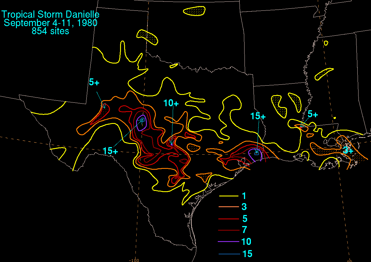
Danielle produced heavy rainfall across eastern and central Texas
and much of southern Louisiana
. A record 17.16 inches (435.9 mm) of rain was reported near Port Arthur
, setting a new 24 hour record. The heavy rainfall resulted in moderate flash flooding and two fatalities Damage estimates from the storm is unknown.
on August 22 and became a tropical depression in the Atlantic Ocean
on August 27 before dissipating. The remnants of the depression then interacted with a mid-level low pressure system over southern Florida
. As a result a low level circulation developed in the Gulf of Mexico
as the combined system moved off Florida
on September 2. Organization continued and a tropical depression formed on September 4 off the southeastern Louisiana coast. Moving west-northwest, the depression slowly intensified where it became a tropical storm on September 5 and was named Danielle by the National Hurricane Center
.
Danielle was a tropical storm for only 11 hours before making landfall; the storm's wind peaked at 60 mi/h and its barometric pressure fell to 1004 millibars before the storm made landfall near Galveston, Texas
. Danielle was then downgraded to tropical depression as the storm moved inland on its westerly track. Danielle then dissipated on September 7 near Del Rio, Texas
and the moisture associated with the remnants of the storm continued westward for the next two days.
 The National Weather Service
forecast the storm to produce 3 inches (76.2 mm)–5 inches (127 mm) of rain and issued flash flood
watches from Freeport
to Sabine Pass
. Offshore, an oil rig reported winds of 60 mi/h with gusts reaching up to 81 mph (130.4 km/h; 66.5 kn) and a barometric pressure of 1004 millibars (which was the storms overall lowest pressure). In the Gulf of Mexico
, rough seas from Danielle caused a maintenance barge to capsize, spilling all 11 crewmen overboard. All but one crewman were rescued by the United States Coast Guard
. Danielle also caused a U.S. Coast Guard helicopter crashed into the sea due to high winds and lack of fuel. All twelve crew men were rescued. Offshore, a barge encountered winds of 58 mph (93.3 km/h; 47.6 kn) with gusts up to 92 mph (148.1 km/h; 75.5 kn) and light rainfall.
Danielle’s effects on southern and eastern Louisiana
was minimal. The state received moderate to heavy rainfall; there, the highest rainfall total there was 2.23 inches (56.6 mm) in Houma
. In Texas
, a weather station near Port Arthur
reported record rainfall for that city of 17.16 inches (435.9 mm). Elsewhere, the town of Nederland
reported 18.29 inches (464.6 mm) of rain. The heavy rainfall caused considerable flash flooding in eastern Texas
causing residents to evacuate their homes. Floodwaters also forced the shutdown of Interstate 10
. Floodwaters also damaged a sewer system in Roscoe
leaving 1,500 residents without running water. In Port Arthur
, twelve homes were reported flooded and in Orange County
two people were injured in automobile accidents. In Beaumont
, one person died in another automobile accident. Danielle also produced tides 2 feet (61 cm)–3 feet (91.4 cm) above normal and minor beach erosion along the Texas
coast and damaged several boats and docks on Lake Buchanan. Elsewhere in Texas, Danielle spawned three tornadoes, one was reported in Alvin
another near Galveston
which damaged a barn and the third was reported southwest of Houston
but did no damage. Two more tornadoes were also reported. After the storm, the American Red Cross
opened storm shelters for residents forced out of their homes because of the flooding and President Jimmy Carter
also declared eastern Texas
a disaster area making the state eligible for federal aid.
Gulf of Mexico
The Gulf of Mexico is a partially landlocked ocean basin largely surrounded by the North American continent and the island of Cuba. It is bounded on the northeast, north and northwest by the Gulf Coast of the United States, on the southwest and south by Mexico, and on the southeast by Cuba. In...
and dissipated after making landfall in east Texas
Texas
Texas is the second largest U.S. state by both area and population, and the largest state by area in the contiguous United States.The name, based on the Caddo word "Tejas" meaning "friends" or "allies", was applied by the Spanish to the Caddo themselves and to the region of their settlement in...
. The fourth tropical cyclone
Tropical cyclone
A tropical cyclone is a storm system characterized by a large low-pressure center and numerous thunderstorms that produce strong winds and heavy rain. Tropical cyclones strengthen when water evaporated from the ocean is released as the saturated air rises, resulting in condensation of water vapor...
of the 1980 Atlantic hurricane season
1980 Atlantic hurricane season
The 1980 Atlantic hurricane season officially began on June 1, 1980, and lasted until November 30, 1980. These dates conventionally delimit the period of each year when most tropical cyclones form in the Atlantic basin. The season was fairly active, with eleven storms forming, of which nine reached...
. Danielle formed as a tropical depression off the Louisiana
Louisiana
Louisiana is a state located in the southern region of the United States of America. Its capital is Baton Rouge and largest city is New Orleans. Louisiana is the only state in the U.S. with political subdivisions termed parishes, which are local governments equivalent to counties...
coast on September 4 and moved westward where it reached tropical storm intensity the following day. After reaching a peak intensity of 60 mph (96.6 km/h; 49.3 kn), Danielle made landfall a few hours later before dissipating on September 7 over central Texas.
Danielle produced heavy rainfall across eastern and central Texas
Texas
Texas is the second largest U.S. state by both area and population, and the largest state by area in the contiguous United States.The name, based on the Caddo word "Tejas" meaning "friends" or "allies", was applied by the Spanish to the Caddo themselves and to the region of their settlement in...
and much of southern Louisiana
Louisiana
Louisiana is a state located in the southern region of the United States of America. Its capital is Baton Rouge and largest city is New Orleans. Louisiana is the only state in the U.S. with political subdivisions termed parishes, which are local governments equivalent to counties...
. A record 17.16 inches (435.9 mm) of rain was reported near Port Arthur
Port Arthur, Texas
-Demographics:As of the 2000 census, there were 57,755 people, 21,839 households, and 14,675 families residing in the city. The population density was 696.5 people per square mile . There were 24,713 housing units at an average density of 298.0 per square mile...
, setting a new 24 hour record. The heavy rainfall resulted in moderate flash flooding and two fatalities Damage estimates from the storm is unknown.
Meteorological history
The origins of Danielle can be traced back to a tropical wave that moved off the coast of AfricaAfrica
Africa is the world's second largest and second most populous continent, after Asia. At about 30.2 million km² including adjacent islands, it covers 6% of the Earth's total surface area and 20.4% of the total land area...
on August 22 and became a tropical depression in the Atlantic Ocean
Atlantic Ocean
The Atlantic Ocean is the second-largest of the world's oceanic divisions. With a total area of about , it covers approximately 20% of the Earth's surface and about 26% of its water surface area...
on August 27 before dissipating. The remnants of the depression then interacted with a mid-level low pressure system over southern Florida
Florida
Florida is a state in the southeastern United States, located on the nation's Atlantic and Gulf coasts. It is bordered to the west by the Gulf of Mexico, to the north by Alabama and Georgia and to the east by the Atlantic Ocean. With a population of 18,801,310 as measured by the 2010 census, it...
. As a result a low level circulation developed in the Gulf of Mexico
Gulf of Mexico
The Gulf of Mexico is a partially landlocked ocean basin largely surrounded by the North American continent and the island of Cuba. It is bounded on the northeast, north and northwest by the Gulf Coast of the United States, on the southwest and south by Mexico, and on the southeast by Cuba. In...
as the combined system moved off Florida
Florida
Florida is a state in the southeastern United States, located on the nation's Atlantic and Gulf coasts. It is bordered to the west by the Gulf of Mexico, to the north by Alabama and Georgia and to the east by the Atlantic Ocean. With a population of 18,801,310 as measured by the 2010 census, it...
on September 2. Organization continued and a tropical depression formed on September 4 off the southeastern Louisiana coast. Moving west-northwest, the depression slowly intensified where it became a tropical storm on September 5 and was named Danielle by the National Hurricane Center
National Hurricane Center
The National Hurricane Center , located at Florida International University in Miami, Florida, is the division of the National Weather Service responsible for tracking and predicting weather systems within the tropics between the Prime Meridian and the 140th meridian west poleward to the 30th...
.
Danielle was a tropical storm for only 11 hours before making landfall; the storm's wind peaked at 60 mi/h and its barometric pressure fell to 1004 millibars before the storm made landfall near Galveston, Texas
Galveston, Texas
Galveston is a coastal city located on Galveston Island in the U.S. state of Texas. , the city had a total population of 47,743 within an area of...
. Danielle was then downgraded to tropical depression as the storm moved inland on its westerly track. Danielle then dissipated on September 7 near Del Rio, Texas
Del Rio, Texas
Del Rio is a border city in and the county seat of Val Verde County, Texas, United States.. Del Rio is connected with Ciudad Acuña via the Lake Amistad Dam International Crossing and Del Río-Ciudad Acuña International Bridge...
and the moisture associated with the remnants of the storm continued westward for the next two days.
Preparations and impact
National Weather Service
The National Weather Service , once known as the Weather Bureau, is one of the six scientific agencies that make up the National Oceanic and Atmospheric Administration of the United States government...
forecast the storm to produce 3 inches (76.2 mm)–5 inches (127 mm) of rain and issued flash flood
Flash flood
A flash flood is a rapid flooding of geomorphic low-lying areas—washes, rivers, dry lakes and basins. It may be caused by heavy rain associated with a storm, hurricane, or tropical storm or meltwater from ice or snow flowing over ice sheets or snowfields...
watches from Freeport
Freeport, Texas
Freeport is a city in Brazoria County, Texas within the Houston–Sugar Land–Baytown metropolitan area and is situated in Southeast Texas. As of the 2000 U.S...
to Sabine Pass
Sabine Pass
Sabine Pass is the natural outlet of Sabine Lake into the Gulf of Mexico. It borders Jefferson County, Texas, and Cameron Parish, Louisiana.Two major battles occurred here during the American Civil War, known as the First and Second Battles of Sabine Pass....
. Offshore, an oil rig reported winds of 60 mi/h with gusts reaching up to 81 mph (130.4 km/h; 66.5 kn) and a barometric pressure of 1004 millibars (which was the storms overall lowest pressure). In the Gulf of Mexico
Gulf of Mexico
The Gulf of Mexico is a partially landlocked ocean basin largely surrounded by the North American continent and the island of Cuba. It is bounded on the northeast, north and northwest by the Gulf Coast of the United States, on the southwest and south by Mexico, and on the southeast by Cuba. In...
, rough seas from Danielle caused a maintenance barge to capsize, spilling all 11 crewmen overboard. All but one crewman were rescued by the United States Coast Guard
United States Coast Guard
The United States Coast Guard is a branch of the United States Armed Forces and one of the seven U.S. uniformed services. The Coast Guard is a maritime, military, multi-mission service unique among the military branches for having a maritime law enforcement mission and a federal regulatory agency...
. Danielle also caused a U.S. Coast Guard helicopter crashed into the sea due to high winds and lack of fuel. All twelve crew men were rescued. Offshore, a barge encountered winds of 58 mph (93.3 km/h; 47.6 kn) with gusts up to 92 mph (148.1 km/h; 75.5 kn) and light rainfall.
Danielle’s effects on southern and eastern Louisiana
Louisiana
Louisiana is a state located in the southern region of the United States of America. Its capital is Baton Rouge and largest city is New Orleans. Louisiana is the only state in the U.S. with political subdivisions termed parishes, which are local governments equivalent to counties...
was minimal. The state received moderate to heavy rainfall; there, the highest rainfall total there was 2.23 inches (56.6 mm) in Houma
Houma, Louisiana
Houma is a city in and the parish seat of Terrebonne Parish, Louisiana, and the largest principal city of the Houma–Bayou Cane–Thibodaux Metropolitan Statistical Area. The city's powers of government have been absorbed by the parish, which is now run by the Terrebonne Parish...
. In Texas
Texas
Texas is the second largest U.S. state by both area and population, and the largest state by area in the contiguous United States.The name, based on the Caddo word "Tejas" meaning "friends" or "allies", was applied by the Spanish to the Caddo themselves and to the region of their settlement in...
, a weather station near Port Arthur
Port Arthur, Texas
-Demographics:As of the 2000 census, there were 57,755 people, 21,839 households, and 14,675 families residing in the city. The population density was 696.5 people per square mile . There were 24,713 housing units at an average density of 298.0 per square mile...
reported record rainfall for that city of 17.16 inches (435.9 mm). Elsewhere, the town of Nederland
Nederland, Texas
Nederland is a city in Jefferson County, Texas, United States. The population was 17,547 at the 2010 census.The city is adjacent to the Southeast Texas Regional Airport in Port Arthur, which serves the nearby cities of Beaumont and Port Arthur. It is part of the Beaumont–Port Arthur...
reported 18.29 inches (464.6 mm) of rain. The heavy rainfall caused considerable flash flooding in eastern Texas
Texas
Texas is the second largest U.S. state by both area and population, and the largest state by area in the contiguous United States.The name, based on the Caddo word "Tejas" meaning "friends" or "allies", was applied by the Spanish to the Caddo themselves and to the region of their settlement in...
causing residents to evacuate their homes. Floodwaters also forced the shutdown of Interstate 10
Interstate 10
Interstate 10 is the fourth-longest Interstate Highway in the United States, after I-90, I-80, and I-40. It is the southernmost east–west, coast-to-coast Interstate Highway, although I-4 and I-8 are further south. It stretches from the Pacific Ocean at State Route 1 in Santa Monica,...
. Floodwaters also damaged a sewer system in Roscoe
Roscoe, Texas
Roscoe is a town in Nolan County, Texas, United States. The population was 1,378 at the 2000 census, but has decreased to only 900.-Geography:Roscoe is located at ....
leaving 1,500 residents without running water. In Port Arthur
Port Arthur, Texas
-Demographics:As of the 2000 census, there were 57,755 people, 21,839 households, and 14,675 families residing in the city. The population density was 696.5 people per square mile . There were 24,713 housing units at an average density of 298.0 per square mile...
, twelve homes were reported flooded and in Orange County
Orange County, Texas
Orange County is one of 254 counties of the State of Texas and its county seat is the city of Orange, Texas. In the year 2000, the population of Orange County was about 85,000. Orange County is the county in the very southeastern corner of Texas, with a boundary with Louisiana and a seacoast on the...
two people were injured in automobile accidents. In Beaumont
Beaumont, Texas
Beaumont is a city in and county seat of Jefferson County, Texas, United States, within the Beaumont–Port Arthur Metropolitan Statistical Area. The city's population was 118,296 at the 2010 census. With Port Arthur and Orange, it forms the Golden Triangle, a major industrial area on the...
, one person died in another automobile accident. Danielle also produced tides 2 feet (61 cm)–3 feet (91.4 cm) above normal and minor beach erosion along the Texas
Texas
Texas is the second largest U.S. state by both area and population, and the largest state by area in the contiguous United States.The name, based on the Caddo word "Tejas" meaning "friends" or "allies", was applied by the Spanish to the Caddo themselves and to the region of their settlement in...
coast and damaged several boats and docks on Lake Buchanan. Elsewhere in Texas, Danielle spawned three tornadoes, one was reported in Alvin
Alvin, Texas
Alvin is a city in the U.S. state of Texas within the Houston–Sugar Land–Baytown metropolitan area and Brazoria County. As of the 2000 U.S. Census, the city population was 21,413. Alvin's claim to fame is Baseball Hall of Famer Nolan Ryan, who moved with his family to the city in 1947 as...
another near Galveston
Galveston, Texas
Galveston is a coastal city located on Galveston Island in the U.S. state of Texas. , the city had a total population of 47,743 within an area of...
which damaged a barn and the third was reported southwest of Houston
Houston, Texas
Houston is the fourth-largest city in the United States, and the largest city in the state of Texas. According to the 2010 U.S. Census, the city had a population of 2.1 million people within an area of . Houston is the seat of Harris County and the economic center of , which is the ...
but did no damage. Two more tornadoes were also reported. After the storm, the American Red Cross
American Red Cross
The American Red Cross , also known as the American National Red Cross, is a volunteer-led, humanitarian organization that provides emergency assistance, disaster relief and education inside the United States. It is the designated U.S...
opened storm shelters for residents forced out of their homes because of the flooding and President Jimmy Carter
Jimmy Carter
James Earl "Jimmy" Carter, Jr. is an American politician who served as the 39th President of the United States and was the recipient of the 2002 Nobel Peace Prize, the only U.S. President to have received the Prize after leaving office...
also declared eastern Texas
Texas
Texas is the second largest U.S. state by both area and population, and the largest state by area in the contiguous United States.The name, based on the Caddo word "Tejas" meaning "friends" or "allies", was applied by the Spanish to the Caddo themselves and to the region of their settlement in...
a disaster area making the state eligible for federal aid.
See also
- List of Texas hurricanes
- Other tropical cyclones named DanielleHurricane DanielleThe name Danielle has been used for six tropical cyclones in the Atlantic Ocean:* Tropical Storm Danielle – flooded the area of Beaumont-Port Arthur, Texas* Tropical Storm Danielle – caused light damage to the Windward Islands...