
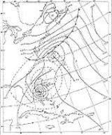
1951 Atlantic hurricane season
Encyclopedia
The 1951 Atlantic hurricane season was moderately active, starting with an pre-season hurricane and lasting until late October. The season
officially started on June 15, when the United States Weather Bureau began its daily monitoring for tropical cyclone activity; the season officially ended on November 15. It was the first year since 1937
in which no hurricanes made landfall
on the United States; as Tropical Storm How
was the only tropical storm to hit the nation, the season had the least tropical cyclone damage in the United States since the 1939 season
. Like the 1950 season
, names from the Joint Army/Navy Phonetic Alphabet
were used to name storms this season.
The first hurricane of the season, Able
, was the earliest major hurricane in Atlantic hurricane history. It formed on May 15 and executed a counterclockwise loop over the Bahamas; later it brushed the North Carolina coastline. Hurricane Charlie
was a powerful hurricane that struck Jamaica, killing hundreds and becoming the worst disaster in over 50 years. The hurricane later struck Mexico twice, producing deadly flooding outside of Tampico, Tamaulipas. The strongest hurricane, Easy
, spent its duration over the open Atlantic Ocean, briefly threatening Bermuda. It interacted
with Hurricane Fox, marking the first known instance of a hurricane affecting another's path.
that exited the East Coast of the United States
on May 12. A low pressure area
developed on May 14, and the next day it developed into a tropical cyclone
about 300 miles (480 km) south of Bermuda
. It formed beneath an upper-level low, and initially was not fully tropical. The depression followed the low, initially toward the northwest and later the southwest. Moving over the Gulf Stream
, the depression intensified into Tropical Storm Able on May 16. The storm turned to the south, and Hurricane Hunters
reported that Able strengthened to hurricane status on May 17 off the coast of Florida.
The outer rainband
s of Able produced light rainfall and high seas along the Florida coastline. It later moved through the Bahamas, where it produced hurricane force winds. The hurricane later turned to the north, gradually strengthening to peak winds of 115 mph (185 km/h) on May 21. Shortly thereafter, Able passed about 70 miles (110 km) east of Cape Hatteras, North Carolina before turning east and rapidly weakening. Along the coast, the hurricane produced high tides but little damage. After weakening to a tropical storm, Able transitioned into an extratropical cyclone
on May 23, before dissipating the next day.
With peak winds of 115 mph (185 km/h), Able became and remains the earliest major hurricane on record. Such a storm is a Category 3 or greater on the Saffir-Simpson Hurricane Scale
, a system developed and introduced in the 1970s. Able was also the strongest hurricane outside of the typical hurricane season, which is defined between June 1 and November 30. The hurricane was one of only four Atlantic hurricanes on record to exist during the month of May, the others occurring in 1889
, 1908
, and 1970.
spawned a tropical depression about 680 miles (1095 km) northeast of Barbuda
in the Lesser Antilles
. It moved northwestward, quickly strengthening into Tropical Storm Baker. Early on August 3, the storm attained peak winds of 60 mph (95 km/h), and the next day passed about 275 mi (442.6 km) east of Bermuda. At its peak intensity, the gale force winds extended 100 miles (160 km) to the north of the center. On August 5, Baker turned to the northeast and began a weakening trend, dissipating later that day. It never affected land.
. After a few days without further development, the system intensified into Tropical Storm Charlie on August 15, and subsequently crossed through the Lesser Antilles. Shortly after entering the Caribbean Sea
, the storm intensified to hurricane status. Passing south of Puerto Rico and Hispaniola, Charlie struck south of Kingston, Jamaica
late on August 17 with winds of 110 mph (175 km/h). On the island, the hurricane dropped heavy rainfall up to 17 in (431.8 mm). The combination of strong winds and the rains left around $50 million (1951 USD, $380 million 2005 USD) in crop and property damage. Across the country there were 152 deaths, 2,000 injuries, and 25,000 people left homeless; as a result, it was considered the worst disaster in the country in the first half of the 20th century.
After exiting Jamaica, Charlie passed south of the Cayman Islands
with 105 mph (165 km/h) sustained winds. Grand Cayman
reported gusts of 92 mph (150 km/h). Later, it attained major hurricane status on August 19. The hurricane peaked at 135 mph (215 km/h) just before hitting near Cozumel
. The strong winds destroyed 70% of the crops along its path, although no deaths were reported in the Yucatán Peninsula. Several homes were wrecked in the region. Charlie weakened rapidly over land, but once over the Gulf of Mexico it re-intensified to its previous peak intensity on August 22. Shortly thereafter it struck Tampico, and it dissipated on August 23. The hurricane dropped heavy rainfall in the region, flooding rivers and causing dams to burst. Hundreds of people were killed in the Mexican mainland, and across Charlie's entire path, damage was estimated at over $75 million (1951 USD, $ USD). The outer fringes of the storm increased surf along the Texas coast.
, several hundred miles east of Barbados
, and it was named "Dog". By that time, its winds were around 60 mph (95 km/h), and the storm continued intensifying as it approached the Lesser Antilles. On September 2, Dog attained hurricane status, and that day passed between Saint Lucia
and Martinique
into the Caribbean Sea. Soon after it reached peak winds of 115 mph (185.1 km/h), which it maintained for about 12 hours before beginning a steady weakening trend. On September 4, Dog weakened to tropical storm status to the south of Hispaniola, and the next day dissipated in the western Caribbean.
In northern Saint Lucia, the combination of flooding and high winds destroyed 70% of the banana crop. Two sailing vessels were destroyed, and another one damaged. Across the island, Hurricane Dog killed two people from drownings. Damage was heavier on Martinique, located on the north side of the storm. The hurricane's winds destroyed 1,000 homes and the roofs of several others. Downed trees blocked roads and disrupted power lines. The winds also destroyed 90% of the banana crop and 30% of the sugar cane. Throughout Martinique, Dog left $3 million in damage (1951 USD
, $ USD) and killed five people from drownings. It was considered the "most violent storm" in Martinique in 20 years. Initially the hurricane was expected to strike Jamaica, prompting hurricane warnings for the country, as well as along the southern coast of Hispaniola. Jamaica was earlier struck by Hurricane Charlie
a few weeks prior, and the threat from Dog prompted coastal evacuations and the closure of an airport. Ultimately, Dog dissipated and produced only light rainfall on the island.
As the hurricane began to weaken, it interacted
with the larger Hurricane Fox to the east; this was the first observed instance of a hurricane affecting another's path. Easy turned to the northeast, passing a short distance southeast of Bermuda on September 9 with winds of 110 mph (177 km/h). On the island, the hurricane produced winds of only 50 mph (80.5 km/h), which downed a few banana trees. Easy transitioned into an extratropical cyclone on September 12, still maintaining hurricane force winds. The remnants dissipated a day later over the northern Atlantic Ocean. In addition to affecting Bermuda, the strong winds of the hurricane damage a few ships along its path.
and Greenland
in the far north Atlantic. It turned toward the north and dissipated on September 11 off the southwest coast of Iceland
. Although a few ships were affected by the hurricane's winds, there were no reports of any damage.
on September 20. Moving west-northwestward, it quickly attained peak winds of 60 mph (95 km/h), as reported by the Hurricane Hunters. After weakening, George made landfall in Mexico about 55 mi (90 km) south of Tampico, Tamaulipas as a minimal tropical storm. Before it moved ashore, the storm spread rainfall along the coast and increased waves, causing one drowning death. George quickly dissipated upon making landfall, and there were no reports of damage.
and the southeast coast. Wind damage was minor, although heavy rainfall was reported, peaking at 15.7 inches (40 cm) near where it moved ashore. The precipitation caused significant street flooding, while about 7000 acres (28.3 km²) of tomato and bean fields were deluged.
The storm emerged into the Atlantic Ocean near Vero Beach
, quickly intensifying to hurricane strength by October 3. Turning northeastward, How reached peak winds of 110 mph (180 km/h) on October 4 as it passed near the Outer Banks of North Carolina. Along the coast, the hurricane produced high tides and minor damage. Subsequently the hurricane began a slow weakening trend. It passed southeast of Cape Cod before turning more to the east-northeast, causing road closures due to high tides. Offshore, the hurricane sank a ship, killing 17 people. How became an extratropical storm on October 7, and the next day dissipated in the far northern Atlantic. Overall, Hurricane How caused about $2 million (1951 USD
, $ USD) in damage.
. Concurrently, the Hurricane Hunters observed peak winds of 80 mph (130 km/h), which the hurricane maintained for 18 hours. A minimum pressure of 997 mbar was also recorded. On October 15, Item weakened below hurricane status as it turned to a west-northwest drift. Continuing a slow weakening trend, it passed just south of Isla de la Juventud before turning northwestward and paralleling the island's west coast. On October 17, Item struck western Cuba, and later that day dissipated in the southeastern Gulf of Mexico.
The threat of the hurricane prompted precautions to be made in portions of Cuba. Additionally, storm warnings were posted in the Florida Keys
, southern mainland Florida, as well as the Bahamas. However, no damage was reported.
. While offshore, the storm increased surf along the North Carolina and Virginia coastlines, prompting storm warnings. On October 19, Jig completed a counterclockwise loop over the western Atlantic. The next day it weakened below tropical storm force before dissipating about 230 mi (370.1 km) south of Bermuda.
Atlantic hurricane season
The Atlantic hurricane season is the period in a year when hurricanes usually form in the Atlantic Ocean. Tropical cyclones in the North Atlantic are called hurricanes, tropical storms, or tropical depressions. In addition, there have been several storms over the years that have not been fully...
officially started on June 15, when the United States Weather Bureau began its daily monitoring for tropical cyclone activity; the season officially ended on November 15. It was the first year since 1937
1937 Atlantic hurricane season
The 1937 Atlantic hurricane season officially began on June 16, 1937, and lasted until October 31, 1937. These dates conventionally delimit the period of each year when most tropical cyclones form in the Atlantic basin....
in which no hurricanes made landfall
Landfall (meteorology)
Landfall is the event of a tropical cyclone or a waterspout coming onto land after being over water. When a waterspout makes landfall it is reclassified as a tornado, which can then cause damage inland...
on the United States; as Tropical Storm How
Hurricane How (1951)
Hurricane How was the only tropical cyclone to make landfall on the United States in 1951. It was the eighth storm of the season, forming on September 28 in the northwest Caribbean and, after entering the Gulf of Mexico, turned eastward and became a tropical storm. The storm brought heavy rainfall...
was the only tropical storm to hit the nation, the season had the least tropical cyclone damage in the United States since the 1939 season
1939 Atlantic hurricane season
The 1939 Atlantic hurricane season officially began on June 16, 1939, and lasted until October 31, 1939. These dates mark the period of each year when most tropical cyclones form in the Atlantic basin...
. Like the 1950 season
1950 Atlantic hurricane season
The 1950 Atlantic hurricane season was the first year in which tropical cyclones were given official names in the Atlantic basin. Names were taken from the Joint Army/Navy Phonetic Alphabet, with the first named storm being designated "Able", the second "Baker", and so on. It was an active season...
, names from the Joint Army/Navy Phonetic Alphabet
Joint Army/Navy Phonetic Alphabet
The Joint Army/Navy Phonetic Alphabet was a radio alphabet developed in 1941 and was used by all branches of the United States military until the promulgation of the ICAO spelling alphabet in 1956, which replaced it...
were used to name storms this season.
The first hurricane of the season, Able
Hurricane Able (1951)
Hurricane Able was the strongest recorded hurricane outside of the typical Atlantic hurricane season. The first tropical cyclone in 1951, Able developed from a trough of low pressure on May 15 about 300 miles south of Bermuda...
, was the earliest major hurricane in Atlantic hurricane history. It formed on May 15 and executed a counterclockwise loop over the Bahamas; later it brushed the North Carolina coastline. Hurricane Charlie
Hurricane Charlie (1951)
Hurricane Charlie was the deadliest tropical cyclone of the 1951 Atlantic hurricane season. The third named storm, second hurricane, and second major hurricane of the season, it developed from a tropical wave east of the Lesser Antilles. It moved briskly west-northwest, passing between the islands...
was a powerful hurricane that struck Jamaica, killing hundreds and becoming the worst disaster in over 50 years. The hurricane later struck Mexico twice, producing deadly flooding outside of Tampico, Tamaulipas. The strongest hurricane, Easy
Hurricane Easy (1951)
Hurricane Easy was the strongest tropical cyclone of the 1951 Atlantic hurricane season. It was a Cape Verde-type hurricane that recurved away from land masses. The fifth tropical cyclone, fourth hurricane, and fourth major hurricane of the season, Easy formed 1,000 miles west of Cape Verde...
, spent its duration over the open Atlantic Ocean, briefly threatening Bermuda. It interacted
Fujiwhara effect
The Fujiwhara effect or Fujiwara interaction, named after Sakuhei Fujiwhara, is a type of interaction between two nearby cyclonic vortices, causing them to appear to "orbit" each other.-Description:...
with Hurricane Fox, marking the first known instance of a hurricane affecting another's path.
Hurricane Able
The origins of the first hurricane of the season were from a troughTrough (meteorology)
A trough is an elongated region of relatively low atmospheric pressure, often associated with fronts.Unlike fronts, there is not a universal symbol for a trough on a weather chart. The weather charts in some countries or regions mark troughs by a line. In the United States, a trough may be marked...
that exited the East Coast of the United States
East Coast of the United States
The East Coast of the United States, also known as the Eastern Seaboard, refers to the easternmost coastal states in the United States, which touch the Atlantic Ocean and stretch up to Canada. The term includes the U.S...
on May 12. A low pressure area
Low pressure area
A low-pressure area, or "low", is a region where the atmospheric pressure at sea level is below that of surrounding locations. Low-pressure systems form under areas of wind divergence which occur in upper levels of the troposphere. The formation process of a low-pressure area is known as...
developed on May 14, and the next day it developed into a tropical cyclone
Tropical cyclone
A tropical cyclone is a storm system characterized by a large low-pressure center and numerous thunderstorms that produce strong winds and heavy rain. Tropical cyclones strengthen when water evaporated from the ocean is released as the saturated air rises, resulting in condensation of water vapor...
about 300 miles (480 km) south of Bermuda
Bermuda
Bermuda is a British overseas territory in the North Atlantic Ocean. Located off the east coast of the United States, its nearest landmass is Cape Hatteras, North Carolina, about to the west-northwest. It is about south of Halifax, Nova Scotia, Canada, and northeast of Miami, Florida...
. It formed beneath an upper-level low, and initially was not fully tropical. The depression followed the low, initially toward the northwest and later the southwest. Moving over the Gulf Stream
Gulf Stream
The Gulf Stream, together with its northern extension towards Europe, the North Atlantic Drift, is a powerful, warm, and swift Atlantic ocean current that originates at the tip of Florida, and follows the eastern coastlines of the United States and Newfoundland before crossing the Atlantic Ocean...
, the depression intensified into Tropical Storm Able on May 16. The storm turned to the south, and Hurricane Hunters
Hurricane Hunters
The Hurricane Hunters are aircraft that fly into tropical cyclones in the North Atlantic Ocean and Northeastern Pacific Ocean for the specific purpose of directly measuring weather data in and around those storms. In the United States, the Air Force, Navy, and NOAA units have all participated in...
reported that Able strengthened to hurricane status on May 17 off the coast of Florida.
The outer rainband
Rainband
A rainband is a cloud and precipitation structure associated with an area of rainfall which is significantly elongated. Rainbands can be stratiform or convective, and are generated by differences in temperature. When noted on weather radar imagery, this precipitation elongation is referred to as...
s of Able produced light rainfall and high seas along the Florida coastline. It later moved through the Bahamas, where it produced hurricane force winds. The hurricane later turned to the north, gradually strengthening to peak winds of 115 mph (185 km/h) on May 21. Shortly thereafter, Able passed about 70 miles (110 km) east of Cape Hatteras, North Carolina before turning east and rapidly weakening. Along the coast, the hurricane produced high tides but little damage. After weakening to a tropical storm, Able transitioned into an extratropical cyclone
Extratropical cyclone
Extratropical cyclones, sometimes called mid-latitude cyclones or wave cyclones, are a group of cyclones defined as synoptic scale low pressure weather systems that occur in the middle latitudes of the Earth having neither tropical nor polar characteristics, and are connected with fronts and...
on May 23, before dissipating the next day.
With peak winds of 115 mph (185 km/h), Able became and remains the earliest major hurricane on record. Such a storm is a Category 3 or greater on the Saffir-Simpson Hurricane Scale
Saffir-Simpson Hurricane Scale
The Saffir–Simpson Hurricane Scale , or the Saffir–Simpson Hurricane Wind Scale , classifies hurricanes — Western Hemisphere tropical cyclones that exceed the intensities of tropical depressions and tropical storms — into five categories distinguished by the intensities of their sustained winds...
, a system developed and introduced in the 1970s. Able was also the strongest hurricane outside of the typical hurricane season, which is defined between June 1 and November 30. The hurricane was one of only four Atlantic hurricanes on record to exist during the month of May, the others occurring in 1889
1889 Atlantic hurricane season
The 1889 Atlantic hurricane season ran through the summer and the first half of fall in 1889.-Hurricane One:Hurricane one formed on May 16...
, 1908
1908 Atlantic hurricane season
The 1908 Atlantic hurricane season ran from June 1 to November 30 in 1908. These dates conventionally delimit the year in which most tropical cyclones form in the Atlantic basin. However, this season got off to a very early start, with a Category 2 hurricane forming on March 6, making it the...
, and 1970.
Tropical Storm Baker
On August 2, an easterly waveTropical wave
Tropical waves, easterly waves, or tropical easterly waves, also known as African easterly waves in the Atlantic region, are a type of atmospheric trough, an elongated area of relatively low air pressure, oriented north to south, which move from east to west across the tropics causing areas of...
spawned a tropical depression about 680 miles (1095 km) northeast of Barbuda
Barbuda
Barbuda is an island in the Eastern Caribbean, and forms part of the state of Antigua and Barbuda. It has a population of about 1,500, most of whom live in the town of Codrington.-Location:...
in the Lesser Antilles
Lesser Antilles
The Lesser Antilles are a long, partly volcanic island arc in the Western Hemisphere. Most of its islands form the eastern boundary of the Caribbean Sea with the Atlantic Ocean, with the remainder located in the southern Caribbean just north of South America...
. It moved northwestward, quickly strengthening into Tropical Storm Baker. Early on August 3, the storm attained peak winds of 60 mph (95 km/h), and the next day passed about 275 mi (442.6 km) east of Bermuda. At its peak intensity, the gale force winds extended 100 miles (160 km) to the north of the center. On August 5, Baker turned to the northeast and began a weakening trend, dissipating later that day. It never affected land.
Hurricane Charlie
The third tropical cyclone of the season developed on August 12 from a tropical wave, 930 miles (1,495 km) east-southeast of BarbadosBarbados
Barbados is an island country in the Lesser Antilles. It is in length and as much as in width, amounting to . It is situated in the western area of the North Atlantic and 100 kilometres east of the Windward Islands and the Caribbean Sea; therein, it is about east of the islands of Saint...
. After a few days without further development, the system intensified into Tropical Storm Charlie on August 15, and subsequently crossed through the Lesser Antilles. Shortly after entering the Caribbean Sea
Caribbean Sea
The Caribbean Sea is a sea of the Atlantic Ocean located in the tropics of the Western hemisphere. It is bounded by Mexico and Central America to the west and southwest, to the north by the Greater Antilles, and to the east by the Lesser Antilles....
, the storm intensified to hurricane status. Passing south of Puerto Rico and Hispaniola, Charlie struck south of Kingston, Jamaica
Kingston, Jamaica
Kingston is the capital and largest city of Jamaica, located on the southeastern coast of the island. It faces a natural harbour protected by the Palisadoes, a long sand spit which connects the town of Port Royal and the Norman Manley International Airport to the rest of the island...
late on August 17 with winds of 110 mph (175 km/h). On the island, the hurricane dropped heavy rainfall up to 17 in (431.8 mm). The combination of strong winds and the rains left around $50 million (1951 USD, $380 million 2005 USD) in crop and property damage. Across the country there were 152 deaths, 2,000 injuries, and 25,000 people left homeless; as a result, it was considered the worst disaster in the country in the first half of the 20th century.
After exiting Jamaica, Charlie passed south of the Cayman Islands
Cayman Islands
The Cayman Islands is a British Overseas Territory and overseas territory of the European Union located in the western Caribbean Sea. The territory comprises the three islands of Grand Cayman, Cayman Brac, and Little Cayman, located south of Cuba and northwest of Jamaica...
with 105 mph (165 km/h) sustained winds. Grand Cayman
Grand Cayman
Grand Cayman is the largest of the three Cayman Islands and the location of the nation's capital, George Town. In relation to the other two Cayman Islands, it is approximately 75 miles southwest of Little Cayman and 90 miles southwest of Cayman Brac.-Geography:Grand Cayman encompasses 76% of...
reported gusts of 92 mph (150 km/h). Later, it attained major hurricane status on August 19. The hurricane peaked at 135 mph (215 km/h) just before hitting near Cozumel
Cozumel
Cozumel is an island in the Caribbean Sea off the eastern coast of Mexico's Yucatan Peninsula, opposite Playa del Carmen, and close to the Yucatan Channel. Cozumel is one of the ten municipalities of the state of Quintana Roo...
. The strong winds destroyed 70% of the crops along its path, although no deaths were reported in the Yucatán Peninsula. Several homes were wrecked in the region. Charlie weakened rapidly over land, but once over the Gulf of Mexico it re-intensified to its previous peak intensity on August 22. Shortly thereafter it struck Tampico, and it dissipated on August 23. The hurricane dropped heavy rainfall in the region, flooding rivers and causing dams to burst. Hundreds of people were killed in the Mexican mainland, and across Charlie's entire path, damage was estimated at over $75 million (1951 USD, $ USD). The outer fringes of the storm increased surf along the Texas coast.
Hurricane Dog
A tropical wave spawned a tropical depression on August 27 southwest of Cape Verde . It moved westward, eventually intensifying into a tropical storm on August 31. The next day, the storm was first observed by Hurricane HuntersHurricane Hunters
The Hurricane Hunters are aircraft that fly into tropical cyclones in the North Atlantic Ocean and Northeastern Pacific Ocean for the specific purpose of directly measuring weather data in and around those storms. In the United States, the Air Force, Navy, and NOAA units have all participated in...
, several hundred miles east of Barbados
Barbados
Barbados is an island country in the Lesser Antilles. It is in length and as much as in width, amounting to . It is situated in the western area of the North Atlantic and 100 kilometres east of the Windward Islands and the Caribbean Sea; therein, it is about east of the islands of Saint...
, and it was named "Dog". By that time, its winds were around 60 mph (95 km/h), and the storm continued intensifying as it approached the Lesser Antilles. On September 2, Dog attained hurricane status, and that day passed between Saint Lucia
Saint Lucia
Saint Lucia is an island country in the eastern Caribbean Sea on the boundary with the Atlantic Ocean. Part of the Lesser Antilles, it is located north/northeast of the island of Saint Vincent, northwest of Barbados and south of Martinique. It covers a land area of 620 km2 and has an...
and Martinique
Martinique
Martinique is an island in the eastern Caribbean Sea, with a land area of . Like Guadeloupe, it is an overseas region of France, consisting of a single overseas department. To the northwest lies Dominica, to the south St Lucia, and to the southeast Barbados...
into the Caribbean Sea. Soon after it reached peak winds of 115 mph (185.1 km/h), which it maintained for about 12 hours before beginning a steady weakening trend. On September 4, Dog weakened to tropical storm status to the south of Hispaniola, and the next day dissipated in the western Caribbean.
In northern Saint Lucia, the combination of flooding and high winds destroyed 70% of the banana crop. Two sailing vessels were destroyed, and another one damaged. Across the island, Hurricane Dog killed two people from drownings. Damage was heavier on Martinique, located on the north side of the storm. The hurricane's winds destroyed 1,000 homes and the roofs of several others. Downed trees blocked roads and disrupted power lines. The winds also destroyed 90% of the banana crop and 30% of the sugar cane. Throughout Martinique, Dog left $3 million in damage (1951 USD
United States dollar
The United States dollar , also referred to as the American dollar, is the official currency of the United States of America. It is divided into 100 smaller units called cents or pennies....
, $ USD) and killed five people from drownings. It was considered the "most violent storm" in Martinique in 20 years. Initially the hurricane was expected to strike Jamaica, prompting hurricane warnings for the country, as well as along the southern coast of Hispaniola. Jamaica was earlier struck by Hurricane Charlie
Hurricane Charlie (1951)
Hurricane Charlie was the deadliest tropical cyclone of the 1951 Atlantic hurricane season. The third named storm, second hurricane, and second major hurricane of the season, it developed from a tropical wave east of the Lesser Antilles. It moved briskly west-northwest, passing between the islands...
a few weeks prior, and the threat from Dog prompted coastal evacuations and the closure of an airport. Ultimately, Dog dissipated and produced only light rainfall on the island.
Hurricane Easy
Hurricane Easy, the strongest in the season, originated as a tropical storm on September 2 between the Lesser Antilles and Cape Verde. It moved generally west-northwestward, intensifying to hurricane status on September 3, and to major hurricane strength two days later. During this period, Hurricane Hunters flew into the hurricane to monitor its progress, recording a minimum pressure of 957 mbar on September 6 to the north of the Lesser Antilles. The next day, an aircraft was unable to penetrate the center, estimating winds of 160 mph (260 km/h) south of the eye; this was Easy's peak intensity. This made Easy a Category 5 hurricane on the Saffir-Simpson scale. Subsequently, the hurricane turned to the north and began a steady weakening trend.As the hurricane began to weaken, it interacted
Fujiwhara effect
The Fujiwhara effect or Fujiwara interaction, named after Sakuhei Fujiwhara, is a type of interaction between two nearby cyclonic vortices, causing them to appear to "orbit" each other.-Description:...
with the larger Hurricane Fox to the east; this was the first observed instance of a hurricane affecting another's path. Easy turned to the northeast, passing a short distance southeast of Bermuda on September 9 with winds of 110 mph (177 km/h). On the island, the hurricane produced winds of only 50 mph (80.5 km/h), which downed a few banana trees. Easy transitioned into an extratropical cyclone on September 12, still maintaining hurricane force winds. The remnants dissipated a day later over the northern Atlantic Ocean. In addition to affecting Bermuda, the strong winds of the hurricane damage a few ships along its path.
Hurricane Fox
Around the same time as Easy was forming, a new tropical depression developed in the far eastern Atlantic Ocean. Moving generally westward, it passed south of the Cape Verde islands, strengthening into Tropical Storm Fox on September 4; by that time, its motion turned to the west-northwest. On September 5, Fox attained hurricane status, around the same time as it was first observed by ships. Two days later, Hurricane Hunters reported peak winds of 115 mph (185.1 km/h), making it a major hurricane. Around that time, Fox interacted with Hurricane to its northwest. After maintaining peak winds for 18 hours, Fox began a steady weakening trend, accelerating to the north and northeast ahead of Easy and passing to the east of Bermuda. On September 10, Fox became extratropical between the AzoresAzores
The Archipelago of the Azores is composed of nine volcanic islands situated in the middle of the North Atlantic Ocean, and is located about west from Lisbon and about east from the east coast of North America. The islands, and their economic exclusion zone, form the Autonomous Region of the...
and Greenland
Greenland
Greenland is an autonomous country within the Kingdom of Denmark, located between the Arctic and Atlantic Oceans, east of the Canadian Arctic Archipelago. Though physiographically a part of the continent of North America, Greenland has been politically and culturally associated with Europe for...
in the far north Atlantic. It turned toward the north and dissipated on September 11 off the southwest coast of Iceland
Iceland
Iceland , described as the Republic of Iceland, is a Nordic and European island country in the North Atlantic Ocean, on the Mid-Atlantic Ridge. Iceland also refers to the main island of the country, which contains almost all the population and almost all the land area. The country has a population...
. Although a few ships were affected by the hurricane's winds, there were no reports of any damage.
Tropical Storm George
Tropical Storm George developed in the Bay of CampecheBay of Campeche
The Bay of Campeche is the southern bight of the Gulf of Mexico. It is surrounded on three sides by the Mexican states of Campeche, Tabasco and Veracruz. It was named by Francisco Hernández de Córdoba and Antonio de Alaminos during their expedition in 1517...
on September 20. Moving west-northwestward, it quickly attained peak winds of 60 mph (95 km/h), as reported by the Hurricane Hunters. After weakening, George made landfall in Mexico about 55 mi (90 km) south of Tampico, Tamaulipas as a minimal tropical storm. Before it moved ashore, the storm spread rainfall along the coast and increased waves, causing one drowning death. George quickly dissipated upon making landfall, and there were no reports of damage.
Hurricane How
An easterly wave spawned a tropical depression in the western Caribbean Sea on September 28. It moved north-northwestward for several days before turning eastward in the central Gulf of Mexico. Based on Hurricane Hunter reports, the depression intensified into Tropical Storm How on October 1, and the next day it crossed southern Florida just below hurricane status. The storm was not well-organized as it crossed the state, and its strongest winds were confined to squalls in the Florida KeysFlorida Keys
The Florida Keys are a coral archipelago in southeast United States. They begin at the southeastern tip of the Florida peninsula, about south of Miami, and extend in a gentle arc south-southwest and then westward to Key West, the westernmost of the inhabited islands, and on to the uninhabited Dry...
and the southeast coast. Wind damage was minor, although heavy rainfall was reported, peaking at 15.7 inches (40 cm) near where it moved ashore. The precipitation caused significant street flooding, while about 7000 acres (28.3 km²) of tomato and bean fields were deluged.
The storm emerged into the Atlantic Ocean near Vero Beach
Vero Beach, Florida
Vero Beach is a city in Indian River County, Florida, USA. According to the U.S. Census Bureau's 2006 estimates, the city had a population of 16,939. It is the county seat of Indian River County...
, quickly intensifying to hurricane strength by October 3. Turning northeastward, How reached peak winds of 110 mph (180 km/h) on October 4 as it passed near the Outer Banks of North Carolina. Along the coast, the hurricane produced high tides and minor damage. Subsequently the hurricane began a slow weakening trend. It passed southeast of Cape Cod before turning more to the east-northeast, causing road closures due to high tides. Offshore, the hurricane sank a ship, killing 17 people. How became an extratropical storm on October 7, and the next day dissipated in the far northern Atlantic. Overall, Hurricane How caused about $2 million (1951 USD
United States dollar
The United States dollar , also referred to as the American dollar, is the official currency of the United States of America. It is divided into 100 smaller units called cents or pennies....
, $ USD) in damage.
Hurricane Item
A tropical depression formed about 285 mi (460 km) south of Jamaica on October 12. A small system, it moved northwestward and intensified into Tropical Storm Item on October 13. It turned toward the northeast, and the next day attained hurricane status before moving through the Cayman IslandsCayman Islands
The Cayman Islands is a British Overseas Territory and overseas territory of the European Union located in the western Caribbean Sea. The territory comprises the three islands of Grand Cayman, Cayman Brac, and Little Cayman, located south of Cuba and northwest of Jamaica...
. Concurrently, the Hurricane Hunters observed peak winds of 80 mph (130 km/h), which the hurricane maintained for 18 hours. A minimum pressure of 997 mbar was also recorded. On October 15, Item weakened below hurricane status as it turned to a west-northwest drift. Continuing a slow weakening trend, it passed just south of Isla de la Juventud before turning northwestward and paralleling the island's west coast. On October 17, Item struck western Cuba, and later that day dissipated in the southeastern Gulf of Mexico.
The threat of the hurricane prompted precautions to be made in portions of Cuba. Additionally, storm warnings were posted in the Florida Keys
Florida Keys
The Florida Keys are a coral archipelago in southeast United States. They begin at the southeastern tip of the Florida peninsula, about south of Miami, and extend in a gentle arc south-southwest and then westward to Key West, the westernmost of the inhabited islands, and on to the uninhabited Dry...
, southern mainland Florida, as well as the Bahamas. However, no damage was reported.
Hurricane Jig
The final tropical cyclone of the season formed on October 15 just north of the Bahamas. Given the name "Jig", it moved northeastward, quickly attaining hurricane status. Twelve hours after forming, the hurricane reached peak winds of 80 mph (128.7 km/h), which it maintained for 18 hours. On October 16, Jig began a slow weakening trend, weakening below hurricane force. The next day, it turned sharply westward, and on October 18 the storm made its closest approach to the southeastern United States while passing about 210 mi (338 km) east-southeast of Cape HatterasCape Hatteras
Cape Hatteras is a cape on the coast of North Carolina. It is the point that protrudes the farthest to the southeast along the northeast-to-southwest line of the Atlantic coast of North America...
. While offshore, the storm increased surf along the North Carolina and Virginia coastlines, prompting storm warnings. On October 19, Jig completed a counterclockwise loop over the western Atlantic. The next day it weakened below tropical storm force before dissipating about 230 mi (370.1 km) south of Bermuda.
Storm names
These names were used to name storms during the 1951 Atlantic hurricane season. As this season had the same names and was less active than 1950, none of these names were used for the first time. Names that were not assigned are marked in .
|
Hurricane How (1951) Hurricane How was the only tropical cyclone to make landfall on the United States in 1951. It was the eighth storm of the season, forming on September 28 in the northwest Caribbean and, after entering the Gulf of Mexico, turned eastward and became a tropical storm. The storm brought heavy rainfall... |
See also
- List of Atlantic hurricanes
- List of Atlantic hurricane seasons