
1937 Atlantic hurricane season
Encyclopedia
The 1937 Atlantic hurricane season officially began on June 16, 1937, and lasted until October 31, 1937. These dates conventionally delimit the period of each year when most tropical cyclone
s form in the Atlantic basin
.
The 1937 season
was not a very active one, with only three hurricanes and no major hurricanes forming during the season and those stayed out to sea. Most of the activity during the ’37 season consisted of tropical storms. Ironically, Nova Scotia
saw more tropical cyclone activity than the entire East Coast of the United States
and the Gulf Coast of the United States
. A tropical storm hit Tampa, Florida
and then grazed Nova Scotia. Tropical storms also hit Daytona Beach, Louisiana
, southern Nova Scotia, and rural northwest Florida
.
The most notable storm of the season actually was not tropical, at the time it made itself notable at least. The extratropical remnant of a hurricane struck just north of Halifax, Nova Scotia
. The storm was moving swiftly, so most of the damage was strictly wind related.
in late July and made landfall just north of St Petersburg, Florida, where gale force winds were reported accompanied by heavy rainfall of up to eight and a half inches. Passing to the northeast, the storm followed the coast, brushing Cape Hatteras
on the last day of July, reaching its peak intensity of 70 mph (near-hurricane force) shortly after. Banking out more to the east, the storm passed well away from Cape Cod
, turning northward late on August 1 and making landfall in southern Nova Scotia
as a weaker system, similar in intensity to when it hit Florida. The storm dissipated over New Brunswick
. Minor flooding and crop damage was reported in Florida, but no damage report exists from Nova Scotia.
on August 8. No damage was reported.
on August 24 and headed northwest, turning westward into the Bahamas three days later, gradually strengthening as it did so. Shortly after grazing Andros Island, it turned sharply northward. The storm curved back to the northwest as it passed Cape Canaveral
, reaching its peak intensity shortly before landfall at Daytona Beach. The storm weakened slowly inland. It maintained a northwesterly course until dissipation on September 2 over central Arkansas
. The storm, though small in size and relatively low in intensity, caused significant damage along its path. It killed 15 people when the steamship Tarpon sank in heavy seas off Panama City
. The storm also felled many trees and power poles in Florida as well as causing minor damage to homes and businesses. Flooding washed out roads and bridges and stopped traffic in Florida's northwestern counties. Flooding in southern Alabama
caused millions of dollars in crop damage and exceptionally high tides were reported along the coast of Georgia. No fatalities were reported, however.
on the Saffir Simpson Hurricane Scale, the next day. It passed roughly 100 miles (160.9 km) east-northeast of Bermuda
while turning more northward. It weakened below hurricane status late on September 13 near Clark's Harbour, Nova Scotia
the next morning. It lost its identity over Chaleur Bay
. No damage or casualties were reported although a British racing yacht, Endeavor I, did go missing for several days in gale conditions with 18 crew on board before it was sighted off Fastnet Rock with all hands safe.
on September 16 and curved northeastward through the central Gulf of Mexico. It was a weak system with winds never exceeding 45 mi/h, but it held that intensity for most of its lifetime. It grazed the Louisiana delta as it turned eastward, travelling along the northeastern Gulf Coast. The storm passed just south of Cape San Blas
, Florida and made landfall near Dekle Beach as a weakening system. It dissipated inland over Florida. Very little damage accompanied the system. Heavy rain fell in the Panhandle that washed over some roads, but that was it.
and the Windward Islands
, a place known as Hurricane Alley the large number of hurricanes that can trace their origins there. It was discovered close to hurricane strength on September 20 and moved generally north-northwestward throughout its lifetime. It became a Category 2 hurricane on the night of September 22 and as far as is known, did not strengthen further. It continued to traverse north-northeast across the open ocean east of Bermuda, maintaining intensity. It became extratropical on the night of September 25, only then weakening to Category 1 intensity. The now-extratropical system recurved to the northeast and struck Nova Scotia with sustained winds of 85 mi/h, crossing just north of Halifax and retained hurricane-force winds into Newfoundland. The storm finally lost its identity near the southern tip of Greenland
. No damage reports exist but gale warnings were ordered as far west as New England
.
. It passed through the northern Bahamas and headed on a north-northeasterly track across the western Atlantic. Its winds never rose above 45 mi/h and it became extratropical late on September 28 having caused little effects.
in late September and moved due north into the Gulf of Mexico, not gaining any intensity as it interacted with another low pressure system (possibly a tropical depression). It turned to the northwest soon after passing the western tip of Cuba and moved across the central Gulf. It then turned northward on October 3, making landfall in Louisiana
near New Iberia
with 40 mi/h winds. No effects from this system were reported.
Tropical cyclone
A tropical cyclone is a storm system characterized by a large low-pressure center and numerous thunderstorms that produce strong winds and heavy rain. Tropical cyclones strengthen when water evaporated from the ocean is released as the saturated air rises, resulting in condensation of water vapor...
s form in the Atlantic basin
Atlantic Basin
The Atlantic Basin is the Atlantic Ocean.Atlantic Basin may also refer to:* Atlantic Basin Iron Works, an ironworks that operated in Brooklyn, New York, in the early to mid-20th century...
.
The 1937 season
Atlantic hurricane season
The Atlantic hurricane season is the period in a year when hurricanes usually form in the Atlantic Ocean. Tropical cyclones in the North Atlantic are called hurricanes, tropical storms, or tropical depressions. In addition, there have been several storms over the years that have not been fully...
was not a very active one, with only three hurricanes and no major hurricanes forming during the season and those stayed out to sea. Most of the activity during the ’37 season consisted of tropical storms. Ironically, Nova Scotia
Nova Scotia
Nova Scotia is one of Canada's three Maritime provinces and is the most populous province in Atlantic Canada. The name of the province is Latin for "New Scotland," but "Nova Scotia" is the recognized, English-language name of the province. The provincial capital is Halifax. Nova Scotia is the...
saw more tropical cyclone activity than the entire East Coast of the United States
East Coast of the United States
The East Coast of the United States, also known as the Eastern Seaboard, refers to the easternmost coastal states in the United States, which touch the Atlantic Ocean and stretch up to Canada. The term includes the U.S...
and the Gulf Coast of the United States
Gulf Coast of the United States
The Gulf Coast of the United States, sometimes referred to as the Gulf South, South Coast, or 3rd Coast, comprises the coasts of American states that are on the Gulf of Mexico, which includes Texas, Louisiana, Mississippi, Alabama, and Florida and are known as the Gulf States...
. A tropical storm hit Tampa, Florida
Tampa, Florida
Tampa is a city in the U.S. state of Florida. It serves as the county seat for Hillsborough County. Tampa is located on the west coast of Florida. The population of Tampa in 2010 was 335,709....
and then grazed Nova Scotia. Tropical storms also hit Daytona Beach, Louisiana
Louisiana
Louisiana is a state located in the southern region of the United States of America. Its capital is Baton Rouge and largest city is New Orleans. Louisiana is the only state in the U.S. with political subdivisions termed parishes, which are local governments equivalent to counties...
, southern Nova Scotia, and rural northwest Florida
Florida
Florida is a state in the southeastern United States, located on the nation's Atlantic and Gulf coasts. It is bordered to the west by the Gulf of Mexico, to the north by Alabama and Georgia and to the east by the Atlantic Ocean. With a population of 18,801,310 as measured by the 2010 census, it...
.
The most notable storm of the season actually was not tropical, at the time it made itself notable at least. The extratropical remnant of a hurricane struck just north of Halifax, Nova Scotia
City of Halifax
Halifax is a city in Canada, which was the capital of the province of Nova Scotia and shire town of Halifax County. It was the largest city in Atlantic Canada until it was amalgamated into Halifax Regional Municipality in 1996...
. The storm was moving swiftly, so most of the damage was strictly wind related.
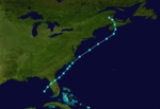
Tropical Storm One
The first storm of the season affected the entire east coast of the United States and parts of maritime Canada. It formed in the Gulf of MexicoGulf of Mexico
The Gulf of Mexico is a partially landlocked ocean basin largely surrounded by the North American continent and the island of Cuba. It is bounded on the northeast, north and northwest by the Gulf Coast of the United States, on the southwest and south by Mexico, and on the southeast by Cuba. In...
in late July and made landfall just north of St Petersburg, Florida, where gale force winds were reported accompanied by heavy rainfall of up to eight and a half inches. Passing to the northeast, the storm followed the coast, brushing Cape Hatteras
Cape Hatteras
Cape Hatteras is a cape on the coast of North Carolina. It is the point that protrudes the farthest to the southeast along the northeast-to-southwest line of the Atlantic coast of North America...
on the last day of July, reaching its peak intensity of 70 mph (near-hurricane force) shortly after. Banking out more to the east, the storm passed well away from Cape Cod
Cape Cod
Cape Cod, often referred to locally as simply the Cape, is a cape in the easternmost portion of the state of Massachusetts, in the Northeastern United States...
, turning northward late on August 1 and making landfall in southern Nova Scotia
Nova Scotia
Nova Scotia is one of Canada's three Maritime provinces and is the most populous province in Atlantic Canada. The name of the province is Latin for "New Scotland," but "Nova Scotia" is the recognized, English-language name of the province. The provincial capital is Halifax. Nova Scotia is the...
as a weaker system, similar in intensity to when it hit Florida. The storm dissipated over New Brunswick
New Brunswick
New Brunswick is one of Canada's three Maritime provinces and is the only province in the federation that is constitutionally bilingual . The provincial capital is Fredericton and Saint John is the most populous city. Greater Moncton is the largest Census Metropolitan Area...
. Minor flooding and crop damage was reported in Florida, but no damage report exists from Nova Scotia.
Tropical Storm Two
Another east coast storm, this one formed in the southern Bahamas in early August as the first storm was dissipating. It was first noticed when the Bahamas reported gale force winds. The storm moved northward through the islands and passed 100 or so miles east of Cape Hatteras, reaching its peak intensity of 60 mi/h at about this time. Gently curving more northeastward, the storm passed about the same distance from Cape Cod. After passing not far south of Nova Scotia as a weakening system, the storm dissipated near Sable IslandSable Island
Sable Island is a small Canadian island situated 300 km southeast of mainland Nova Scotia in the Atlantic Ocean. The island is a year-round home to approximately five people...
on August 8. No damage was reported.
Tropical Storm Three
The season's third storm formed near the Leeward IslandsLeeward Islands
The Leeward Islands are a group of islands in the West Indies. They are the northern islands of the Lesser Antilles chain. As a group they start east of Puerto Rico and reach southward to Dominica. They are situated where the northeastern Caribbean Sea meets the western Atlantic Ocean...
on August 24 and headed northwest, turning westward into the Bahamas three days later, gradually strengthening as it did so. Shortly after grazing Andros Island, it turned sharply northward. The storm curved back to the northwest as it passed Cape Canaveral
Cape Canaveral
Cape Canaveral, from the Spanish Cabo Cañaveral, is a headland in Brevard County, Florida, United States, near the center of the state's Atlantic coast. Known as Cape Kennedy from 1963 to 1973, it lies east of Merritt Island, separated from it by the Banana River.It is part of a region known as the...
, reaching its peak intensity shortly before landfall at Daytona Beach. The storm weakened slowly inland. It maintained a northwesterly course until dissipation on September 2 over central Arkansas
Arkansas
Arkansas is a state located in the southern region of the United States. Its name is an Algonquian name of the Quapaw Indians. Arkansas shares borders with six states , and its eastern border is largely defined by the Mississippi River...
. The storm, though small in size and relatively low in intensity, caused significant damage along its path. It killed 15 people when the steamship Tarpon sank in heavy seas off Panama City
Panama City, Florida
-Personal income:The median income for a household in the city was $31,572, and the median income for a family was $40,890. Males had a median income of $30,401 versus $21,431 for females. The per capita income for the city was $17,830...
. The storm also felled many trees and power poles in Florida as well as causing minor damage to homes and businesses. Flooding washed out roads and bridges and stopped traffic in Florida's northwestern counties. Flooding in southern Alabama
Alabama
Alabama is a state located in the southeastern region of the United States. It is bordered by Tennessee to the north, Georgia to the east, Florida and the Gulf of Mexico to the south, and Mississippi to the west. Alabama ranks 30th in total land area and ranks second in the size of its inland...
caused millions of dollars in crop damage and exceptionally high tides were reported along the coast of Georgia. No fatalities were reported, however.
Hurricane Four
The 1937 season's first hurricane was discovered about 200 miles (321.9 km) east of the Leeward Islands on September 9 when it was nearly at hurricane force. The hurricane headed northwest, slowly at first but then gaining speed on September 11 as it steadily strengthened. It reached its peak intensity of 100 mi/h, Category 2Saffir-Simpson Hurricane Scale
The Saffir–Simpson Hurricane Scale , or the Saffir–Simpson Hurricane Wind Scale , classifies hurricanes — Western Hemisphere tropical cyclones that exceed the intensities of tropical depressions and tropical storms — into five categories distinguished by the intensities of their sustained winds...
on the Saffir Simpson Hurricane Scale, the next day. It passed roughly 100 miles (160.9 km) east-northeast of Bermuda
Bermuda
Bermuda is a British overseas territory in the North Atlantic Ocean. Located off the east coast of the United States, its nearest landmass is Cape Hatteras, North Carolina, about to the west-northwest. It is about south of Halifax, Nova Scotia, Canada, and northeast of Miami, Florida...
while turning more northward. It weakened below hurricane status late on September 13 near Clark's Harbour, Nova Scotia
Clark's Harbour, Nova Scotia
Clark's Harbour is a town on Cape Sable Island in southwestern Nova Scotia, Canada, located in the Barrington municipal district of Shelburne County. The main industry is lobster fishing. The community is noted as the birthplace of the Cape Islander fishing boat...
the next morning. It lost its identity over Chaleur Bay
Chaleur Bay
frame| Satellite image of Chaleur Bay . Chaleur Bay is the large bay opening to the east;the [[Gaspé Peninsula]] appears to the north and the [[Gulf of St...
. No damage or casualties were reported although a British racing yacht, Endeavor I, did go missing for several days in gale conditions with 18 crew on board before it was sighted off Fastnet Rock with all hands safe.
Hurricane Five
Storm Five was the strongest storm of the 1937 season. This storm was first discovered on September 14 at near-hurricane intensity about 200 miles (321.9 km) east of the Leeward Islands. The storm strengthened to a hurricane and turned north then east, continuing to intensify as it did so. The storm reached its peak intensity of 110 mi/h, just shy of major hurricane status, on September 16 as it turned to the north-northeast. The storm maintained this track and Category 2 intensity throughout most of the rest of its lifetime. On September 18 it curved more to the northeast and weakened to a Category 1 that evening. The storm became extratropical the next day as it crossed 45N latitude.Tropical Storm Six
Storm Six developed in the Bay of CampecheBay of Campeche
The Bay of Campeche is the southern bight of the Gulf of Mexico. It is surrounded on three sides by the Mexican states of Campeche, Tabasco and Veracruz. It was named by Francisco Hernández de Córdoba and Antonio de Alaminos during their expedition in 1517...
on September 16 and curved northeastward through the central Gulf of Mexico. It was a weak system with winds never exceeding 45 mi/h, but it held that intensity for most of its lifetime. It grazed the Louisiana delta as it turned eastward, travelling along the northeastern Gulf Coast. The storm passed just south of Cape San Blas
Cape San Blas
Cape San Blas is part of a peninsula in Gulf County, Florida extending westward from the mainland of Florida, separating St. Joseph Bay to the north from the Gulf Of Mexico to the south. The St. Joseph Peninsula extends northward from the west end of Cape San Blas. It is approximately 10 miles...
, Florida and made landfall near Dekle Beach as a weakening system. It dissipated inland over Florida. Very little damage accompanied the system. Heavy rain fell in the Panhandle that washed over some roads, but that was it.
Hurricane Seven
The third and final hurricane of the season formed in the open Atlantic between Cape VerdeCape Verde
The Republic of Cape Verde is an island country, spanning an archipelago of 10 islands located in the central Atlantic Ocean, 570 kilometres off the coast of Western Africa...
and the Windward Islands
Windward Islands
The Windward Islands are the southern islands of the Lesser Antilles, within the West Indies.-Name and geography:The Windward Islands are called such because they were more windward to sailing ships arriving in the New World than the Leeward Islands, given that the prevailing trade winds in the...
, a place known as Hurricane Alley the large number of hurricanes that can trace their origins there. It was discovered close to hurricane strength on September 20 and moved generally north-northwestward throughout its lifetime. It became a Category 2 hurricane on the night of September 22 and as far as is known, did not strengthen further. It continued to traverse north-northeast across the open ocean east of Bermuda, maintaining intensity. It became extratropical on the night of September 25, only then weakening to Category 1 intensity. The now-extratropical system recurved to the northeast and struck Nova Scotia with sustained winds of 85 mi/h, crossing just north of Halifax and retained hurricane-force winds into Newfoundland. The storm finally lost its identity near the southern tip of Greenland
Greenland
Greenland is an autonomous country within the Kingdom of Denmark, located between the Arctic and Atlantic Oceans, east of the Canadian Arctic Archipelago. Though physiographically a part of the continent of North America, Greenland has been politically and culturally associated with Europe for...
. No damage reports exist but gale warnings were ordered as far west as New England
New England
New England is a region in the northeastern corner of the United States consisting of the six states of Maine, New Hampshire, Vermont, Massachusetts, Rhode Island, and Connecticut...
.
Tropical Storm Eight
Storm Eight was first recognized southwest of Andros Island on September 26 near the north coast of CubaCuba
The Republic of Cuba is an island nation in the Caribbean. The nation of Cuba consists of the main island of Cuba, the Isla de la Juventud, and several archipelagos. Havana is the largest city in Cuba and the country's capital. Santiago de Cuba is the second largest city...
. It passed through the northern Bahamas and headed on a north-northeasterly track across the western Atlantic. Its winds never rose above 45 mi/h and it became extratropical late on September 28 having caused little effects.
Tropical Storm Nine
The season went quietly with yet another weak system. It formed off the north coast of HondurasHonduras
Honduras is a republic in Central America. It was previously known as Spanish Honduras to differentiate it from British Honduras, which became the modern-day state of Belize...
in late September and moved due north into the Gulf of Mexico, not gaining any intensity as it interacted with another low pressure system (possibly a tropical depression). It turned to the northwest soon after passing the western tip of Cuba and moved across the central Gulf. It then turned northward on October 3, making landfall in Louisiana
Louisiana
Louisiana is a state located in the southern region of the United States of America. Its capital is Baton Rouge and largest city is New Orleans. Louisiana is the only state in the U.S. with political subdivisions termed parishes, which are local governments equivalent to counties...
near New Iberia
New Iberia, Louisiana
New Iberia is a city in and the parish seat of Iberia Parish, Louisiana, United States, 30 miles southeast of Lafayette. In 1900, 6,815 people lived in New Iberia; in 1910, 7,499; and in 1940, 13,747...
with 40 mi/h winds. No effects from this system were reported.
See also
- List of tropical cyclones
- List of Atlantic hurricane seasons