
1906 Atlantic hurricane season
Encyclopedia
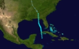
The 1906 Atlantic hurricane season was the eleventh-deadliest Atlantic hurricane season
in recorded history, with 381 deaths. The season was fairly active, with eleven storms, of which six became hurricanes and three became major hurricanes. The first storm of the season, a tropical storm in the northern Caribbean Sea
, formed on June 8; although it struck the United States, no major impacts were recorded. July saw a period of inactivity, with no known storms. However, in August, the streak of inactivity ended with two storms, including a powerful hurricane. September brought three storms, including a deadly hurricane
caused catastrophic impacts in Pensacola
and Mobile
. October included three storms, with a powerful hurricane
that killed over 200 people. The final storm of the season impacted Cuba
in early November and dissipated on November 9.
of hurricane seasons between 1851 and 1910. Partagás also extended the known tracks of three other hurricanes previously identified by scholars. The information Partagás and his colleague uncovered was largely adopted by the National Oceanic and Atmospheric Administration
's Atlantic hurricane reanalysis in their updates to the Atlantic hurricane database
(HURDAT), with some slight adjustments. HURDAT is the official source for such hurricane data as track and intensity, although due to a sparsity of available records at the time the storms existed, listings on some storms are incomplete.
Although extrapolated peak maximum sustained wind
s based on whatever reports are available exist for every storm in 1906, estimated minimum central barometric air pressure listings are only present for the three storms that made landfall in the United States. As the three landfalling storms progressed inland, information on their meteorological demise was limited. As a result, the intensity of these storms after landfall and until dissipation is based on an inland decay model developed in 1995 to predict the deterioration of inland hurricanes.
; 29.59 inHg); however, the minimum pressure of the system itself is unknown. On June 12, the system caused the sinking of a schooner; however, all on board the schooner were rescued. The system continued traveling north-northwestward, making landfall near Panama City
on June 13, quickly weakening to a tropical depression as it moved inland. The system became extratropical by June 14, dissipating shortly thereafter; no deaths and injuries are known to have been caused by the storm.
, where rainy and windy conditions were observed on the afternoon of June 14. Several vessels sank during the hurricane during the early morning hours of June 15. The system was thought to have entered the Florida Straits
during the evening. The system began to travel towards the west-northwest, steadily strengthening into a hurricane by the afternoon. On June 17, a minimum pressure of 979 mbar (hPa; 28.91 inHg) was recorded, as the hurricane passed over southern Florida
.
The hurricane slowly intensified as it traveled offshore, continuing to strengthen throughout the day on June 17, eventually reaching Category 2 status by June 18. As the storm headed northeastward, the hurricane began to weaken, becoming a tropical storm by June 21. The system turned toward the east-southeast on June 21, later recurving towards the east-northeast on June 22. It weakened to a tropical depression by June 23, transitioning into an extratropical cyclone
later that day. Impacts caused by the hurricane were minimal—a boat was partially dismantled at Key West
, and a wharf
at Coconut Grove was also damaged. In addition, the schooner Hidie Feroe sank, although its crew was later rescued.
as a Category 2 hurricane. The storm became a Category 3 hurricane on September 2 as it passed north of the Dominican Republic
. The storm further intensified into a Category 4 hurricane on September 5, located east of the Bahamas
. Throughout the day on September 6, the hurricane began to curve northward. During the evening, it weakened to Category 3 status and began to travel northeastward on September 7.
The hurricane maintained its intensity and passed northwest of Bermuda
on September 9, where winds reached 70 mph (110 km/h) and air pressures fell to 988 mbar (hPa; 29.18 inHg). The storm continued to weaken, eventually becoming a Category 2 hurricane on September 11; at this time, the Koenigin Luise measured an air pressure of 950 mbar (hPa; 28.06 inHg). The system became extratropical later during the day, and lost its identity on September 12 in the North Atlantic near the British Isles
. As a result of warnings in advance, little damage was caused by the hurricane.
on September 17. The hurricane made landfall near Myrtle Beach
later on September 17, and quickly weakened to a tropical storm as it moved inland. The storm dissipated as a tropical depression on September 18 over Tennessee.
The hurricane caused moderate impacts — two hundred people were stranded at Wrightsville Beach, North Carolina
. At Charleston, South Carolina
, winds of 46 mph (74 km/h) were recorded, in addition to a barometric pressure of 997 mbar (hPa; 29.44 inHg). Many small buildings were damaged in Charleston; damage in the city totaled to $1,000, while at the town of Georgetown
, damage was estimated to be around $15,000. The Laura encountered the hurricane, and three of the crew of four were killed. A schooner called the Seguranca and its crew were also impacted by the hurricane; the crew on board survived without food for two days. Overall damage to shipping and crops in the Carolinas was moderate; seven people were killed, and at least $2,016,000 (1906 USD
) in damage was recorded.
. The hurricane continued to intensify as it moved north-northwest and attained Category 2 intensity in the Gulf of Mexico
. During the afternoon, the storm intensified further into a major hurricane. At this time, the hurricane was 300 miles (480 km) west-northwest of Cuba. The hurricane maintained intensity and continued to drift north-northwest, and weakened to a Category 2 hurricane as it made landfall near Pascagoula, Mississippi
on September 27. The hurricane weakened as it moved inland, quickly weakening to a tropical storm by September 28. The storm became extratropical on September 29.
The hurricane caused severe damage along the Gulf Coast
. Many marine vessels
were blown ashore or sunken in Pensacola, and railroads in the city were severely damaged. Numerous wharfs were damaged or destroyed, and many roofs were torn off buildings. Three forts in the vicinity of Pensacola suffered damage. Electricity in the city was shut off. A total of 35 people were killed in Pensacola. Mobile and surrounding areas suffered similar damage, including destroyed timber, smashed windows, and sunken watercraft. In Mississippi
, over 300,000 cotton bales were ruined during the hurricane, amounting to $12,000,000 in damage. Damage in New Orleans was minimal; however, Lake Pontchartrain
overflowed, flooding the city. The hurricane killed a total of 134 people.
in the northeastern Atlantic on September 22. The tropical storm moved west-southwestward for several days, maintaining its peak winds of 70 mph (110 km/h); however, the storm began to curve early on September 26 and traveled directly westward before curving northward during the afternoon. The tropical storm continued to change course, turning west-northwestward by September 28. The transitioned to an extratropical system on October 1, and reached England
on October 3.
as a "cyclonic perturbation"; however, no closed circulation was evidently associated with the system. Barometric pressures began sinking in Panama
as the system drifted westward, and it was considered a tropical storm by October 8. As the storm headed west, it rapidly strengthened; the storm became a hurricane on October 9 and intensified into a major hurricane on October 10. As it began to curve northwestward, the hurricane made landfall in Nicaragua
, and weakened to a tropical storm on October 11. It began to drift north-northwestward later that day, intensifying into a minimal hurricane as it drifted into the Gulf of Honduras
.
However, the hurricane weakened to a tropical storm again on October 14 as it moved overland, and began to curve north-northwest, restrengthening to a major hurricane by October 17 while it was west-southwest of Cuba. The hurricane made landfall over Cuba on the evening of October 17. The hurricane passed over southern Florida on October 18. The hurricane continued traveling north-northwest; however, it was forced to re-curve south-southwest, as a result of a high-pressure area. The hurricane weakened to a tropical storm overland, eventually becoming a tropical depression. The system meandred into the Gulf of Mexico, making a final landfall in Central America on October 23.
The hurricane wreaked havoc throughout its path — crops in Central America suffered severe damage, and rainfall destroyed many roads and bridges in Nicaragua
. In Cuba, at least 29 people were killed, and tobacco crops in the country were ruined. The most severe damage was caused in Florida — the state suffered more than $420,000 in damage and more than two hundred people were killed. Of the people killed in Florida, 135 were workers on the Florida East Coast Railway
, and more than 70 people were drowned near Elliott Key
after two steamers sank. Throughout its path, damage caused by the hurricane totaled to at least $4,135,000 and at least 240 deaths were recorded.
on October 14. The storm moved westward; however, it began to curve west-southwestward on October 15, as it reached its peak winds of 50 mph (85 km/h). The storm continued to trek towards the west-southwest on October 16, later making landfall in eastern Florida on October 17 as a tropical depression. No damage is known to have been caused by the tropical storm.
. The tropical storm moved northwest, but changed direction and began to curve northeastward on October 17. As the storm moved eastward, it slowly strengthened; the storm attained its peak winds of 50 mph (85 km/h) on October 18. The tropical storm headed directly eastward on October 19, and dissipated in the open Atlantic on October 20.
Atlantic hurricane season
The Atlantic hurricane season is the period in a year when hurricanes usually form in the Atlantic Ocean. Tropical cyclones in the North Atlantic are called hurricanes, tropical storms, or tropical depressions. In addition, there have been several storms over the years that have not been fully...
in recorded history, with 381 deaths. The season was fairly active, with eleven storms, of which six became hurricanes and three became major hurricanes. The first storm of the season, a tropical storm in the northern Caribbean Sea
Caribbean Sea
The Caribbean Sea is a sea of the Atlantic Ocean located in the tropics of the Western hemisphere. It is bounded by Mexico and Central America to the west and southwest, to the north by the Greater Antilles, and to the east by the Lesser Antilles....
, formed on June 8; although it struck the United States, no major impacts were recorded. July saw a period of inactivity, with no known storms. However, in August, the streak of inactivity ended with two storms, including a powerful hurricane. September brought three storms, including a deadly hurricane
1906 Pensacola hurricane
The 1906 Pensacola hurricane was a deadly and destructive hurricane during the 1906 Atlantic hurricane season. The fourth hurricane of the season, the system was originally observed in the western Caribbean on September 22; however, modern research revealed that the system became a tropical...
caused catastrophic impacts in Pensacola
Pensacola
Pensacola is a city in the western part of the U.S. state of Florida.Pensacola may also refer to:* Pensacola people, a group of Native Americans* A number of places in the Florida:** Pensacola Bay** Pensacola Regional Airport...
and Mobile
Mobile, Alabama
Mobile is the third most populous city in the Southern US state of Alabama and is the county seat of Mobile County. It is located on the Mobile River and the central Gulf Coast of the United States. The population within the city limits was 195,111 during the 2010 census. It is the largest...
. October included three storms, with a powerful hurricane
1906 Florida Keys hurricane
The 1906 Florida Keys hurricane was a powerful and deadly hurricane that caused major impacts in Cuba and southern Florida. The fifth hurricane and third major hurricane of the season, the storm formed from a system near Barbados on October 4. By October 8, it had intensified into a tropical storm,...
that killed over 200 people. The final storm of the season impacted Cuba
Cuba
The Republic of Cuba is an island nation in the Caribbean. The nation of Cuba consists of the main island of Cuba, the Isla de la Juventud, and several archipelagos. Havana is the largest city in Cuba and the country's capital. Santiago de Cuba is the second largest city...
in early November and dissipated on November 9.
Methodology
Prior to the advent of modern tropical cyclone tracking technology, notably satellite imagery, many hurricanes that did not affect land directly went unnoticed, and storms that did affect land were not recognized until their onslaught. As a result, information on older hurricane seasons was often incomplete. Modern-day efforts have been made and are still ongoing to reconstruct the tracks of known hurricanes and to identify initially undetected storms. In many cases, the only evidence that a hurricane existed was reports from ships in its path, and judging by the direction of winds experienced by ships, and their location in relation to the storm, it is possible to roughly pinpoint the storm's center of circulation for a given point in time. This is the manner in which all of the eleven known storms in the 1906 season were identified by hurricane expert José Fernández-Partagás's reanalysisAtlantic hurricane reanalysis
Atlantic hurricane reanalysis is an ongoing project within the National Oceanic and Atmospheric Administration which seeks to correct and add new information about past Atlantic tropical cyclones...
of hurricane seasons between 1851 and 1910. Partagás also extended the known tracks of three other hurricanes previously identified by scholars. The information Partagás and his colleague uncovered was largely adopted by the National Oceanic and Atmospheric Administration
National Oceanic and Atmospheric Administration
The National Oceanic and Atmospheric Administration , pronounced , like "noah", is a scientific agency within the United States Department of Commerce focused on the conditions of the oceans and the atmosphere...
's Atlantic hurricane reanalysis in their updates to the Atlantic hurricane database
HURDAT
The North Atlantic hurricane database, or HURDAT, is the database for all tropical cyclones in the Atlantic Ocean, Gulf of Mexico and Caribbean Sea, since 1851.-History:...
(HURDAT), with some slight adjustments. HURDAT is the official source for such hurricane data as track and intensity, although due to a sparsity of available records at the time the storms existed, listings on some storms are incomplete.
Although extrapolated peak maximum sustained wind
Maximum sustained wind
The maximum sustained winds associated with a tropical cyclone are a common indicator of the intensity of the storm. Within a mature tropical cyclone, they are found within the eyewall at a distance defined as the radius of maximum wind, or RMW. Unlike gusts, the value of these winds are...
s based on whatever reports are available exist for every storm in 1906, estimated minimum central barometric air pressure listings are only present for the three storms that made landfall in the United States. As the three landfalling storms progressed inland, information on their meteorological demise was limited. As a result, the intensity of these storms after landfall and until dissipation is based on an inland decay model developed in 1995 to predict the deterioration of inland hurricanes.
Tropical Storm One
The first storm of the season formed on June 8, south of western Cuba, attaining its peak winds of 50 mph (80 km/h) by June 9. On June 10, a weather station in Havana reported a minimum air pressure of 1002 mbar (hPaHPA
-Organizations:*Halifax Port Authority, a port authority in Canada*Hamburg Port Authority, the port authority for the Port of Hamburg, Germany*Health Protection Agency, a health organization in the United Kingdom...
; 29.59 inHg); however, the minimum pressure of the system itself is unknown. On June 12, the system caused the sinking of a schooner; however, all on board the schooner were rescued. The system continued traveling north-northwestward, making landfall near Panama City
Panama City, Florida
-Personal income:The median income for a household in the city was $31,572, and the median income for a family was $40,890. Males had a median income of $30,401 versus $21,431 for females. The per capita income for the city was $17,830...
on June 13, quickly weakening to a tropical depression as it moved inland. The system became extratropical by June 14, dissipating shortly thereafter; no deaths and injuries are known to have been caused by the storm.
Hurricane Two
This first hurricane of the season's effects were first noted in Santa Clara, CubaSanta Clara, Cuba
Santa Clara is the capital city of the Cuban province of Villa Clara. It is located in the most central region of the province and almost in the most central region of the country.- History :Santa Clara was founded by 175 people on July 15th, 1689...
, where rainy and windy conditions were observed on the afternoon of June 14. Several vessels sank during the hurricane during the early morning hours of June 15. The system was thought to have entered the Florida Straits
Straits of Florida
The Straits of Florida, Florida Straits, or Florida Strait is a strait located south-southeast of the North American mainland, generally accepted to be between the Gulf of Mexico and the Atlantic Ocean, and between the Florida Keys and Cuba. The strait carries the Florida Current, the beginning of...
during the evening. The system began to travel towards the west-northwest, steadily strengthening into a hurricane by the afternoon. On June 17, a minimum pressure of 979 mbar (hPa; 28.91 inHg) was recorded, as the hurricane passed over southern Florida
Florida
Florida is a state in the southeastern United States, located on the nation's Atlantic and Gulf coasts. It is bordered to the west by the Gulf of Mexico, to the north by Alabama and Georgia and to the east by the Atlantic Ocean. With a population of 18,801,310 as measured by the 2010 census, it...
.
The hurricane slowly intensified as it traveled offshore, continuing to strengthen throughout the day on June 17, eventually reaching Category 2 status by June 18. As the storm headed northeastward, the hurricane began to weaken, becoming a tropical storm by June 21. The system turned toward the east-southeast on June 21, later recurving towards the east-northeast on June 22. It weakened to a tropical depression by June 23, transitioning into an extratropical cyclone
Extratropical cyclone
Extratropical cyclones, sometimes called mid-latitude cyclones or wave cyclones, are a group of cyclones defined as synoptic scale low pressure weather systems that occur in the middle latitudes of the Earth having neither tropical nor polar characteristics, and are connected with fronts and...
later that day. Impacts caused by the hurricane were minimal—a boat was partially dismantled at Key West
Key West
Key West is an island in the Straits of Florida on the North American continent at the southernmost tip of the Florida Keys. Key West is home to the southernmost point in the Continental United States; the island is about from Cuba....
, and a wharf
Wharf
A wharf or quay is a structure on the shore of a harbor where ships may dock to load and unload cargo or passengers.Such a structure includes one or more berths , and may also include piers, warehouses, or other facilities necessary for handling the ships.A wharf commonly comprises a fixed...
at Coconut Grove was also damaged. In addition, the schooner Hidie Feroe sank, although its crew was later rescued.
Tropical Storm Three
This tropical storm was previously unidentified until modern research revealed by José Fernández-Partagás revealed the storm in 1997. The tropical storm is believed to have originated as a tropical depression in the North Atlantic on August 22. By August 23, the depression had intensified into a tropical storm, with winds of 40 mph (65 km/h). The system further intensified into a powerful tropical storm on August 24, with winds of 70 mph (110 km/h). However, the storm began to weaken, and it transitioned into an extratropical storm on August 25, with winds of 60 mph (95 km/h).Hurricane Four
The fourth storm of the season was believed to have originated as a tropical storm off the coast of Africa on August 25. The storm slowly intensified, eventually reaching hurricane status on August 28. As the storm headed west-northwestward on August 31, it passed by the Lesser AntillesLesser Antilles
The Lesser Antilles are a long, partly volcanic island arc in the Western Hemisphere. Most of its islands form the eastern boundary of the Caribbean Sea with the Atlantic Ocean, with the remainder located in the southern Caribbean just north of South America...
as a Category 2 hurricane. The storm became a Category 3 hurricane on September 2 as it passed north of the Dominican Republic
Dominican Republic
The Dominican Republic is a nation on the island of La Hispaniola, part of the Greater Antilles archipelago in the Caribbean region. The western third of the island is occupied by the nation of Haiti, making Hispaniola one of two Caribbean islands that are shared by two countries...
. The storm further intensified into a Category 4 hurricane on September 5, located east of the Bahamas
The Bahamas
The Bahamas , officially the Commonwealth of the Bahamas, is a nation consisting of 29 islands, 661 cays, and 2,387 islets . It is located in the Atlantic Ocean north of Cuba and Hispaniola , northwest of the Turks and Caicos Islands, and southeast of the United States...
. Throughout the day on September 6, the hurricane began to curve northward. During the evening, it weakened to Category 3 status and began to travel northeastward on September 7.
The hurricane maintained its intensity and passed northwest of Bermuda
Bermuda
Bermuda is a British overseas territory in the North Atlantic Ocean. Located off the east coast of the United States, its nearest landmass is Cape Hatteras, North Carolina, about to the west-northwest. It is about south of Halifax, Nova Scotia, Canada, and northeast of Miami, Florida...
on September 9, where winds reached 70 mph (110 km/h) and air pressures fell to 988 mbar (hPa; 29.18 inHg). The storm continued to weaken, eventually becoming a Category 2 hurricane on September 11; at this time, the Koenigin Luise measured an air pressure of 950 mbar (hPa; 28.06 inHg). The system became extratropical later during the day, and lost its identity on September 12 in the North Atlantic near the British Isles
British Isles
The British Isles are a group of islands off the northwest coast of continental Europe that include the islands of Great Britain and Ireland and over six thousand smaller isles. There are two sovereign states located on the islands: the United Kingdom of Great Britain and Northern Ireland and...
. As a result of warnings in advance, little damage was caused by the hurricane.
Hurricane Five
The fifth storm of the season formed on September 3 in the western Atlantic. It drifted west-northwestward, slowly gaining intensity, and turned northwest on September 8. However, the tropical storm then changed course and began to head west-northwest on September 11 as it slowly intensified. By September 12, the tropical storm had intensified to a minimal hurricane, and began to turn towards the north-northwest on September 13. It attained its peak winds of 90 mph (150 km/h) on September 14. As it maintained its intensity on September 15, the hurricane began to turn westward while it continued to approach the coast of South CarolinaSouth Carolina
South Carolina is a state in the Deep South of the United States that borders Georgia to the south, North Carolina to the north, and the Atlantic Ocean to the east. Originally part of the Province of Carolina, the Province of South Carolina was one of the 13 colonies that declared independence...
on September 17. The hurricane made landfall near Myrtle Beach
Myrtle Beach, South Carolina
Myrtle Beach is a coastal city on the east coast of the United States in Horry County, South Carolina. It is situated on the center of a large and continuous stretch of beach known as the Grand Strand in northeastern South Carolina. It is considered to be a major tourist destination in the...
later on September 17, and quickly weakened to a tropical storm as it moved inland. The storm dissipated as a tropical depression on September 18 over Tennessee.
The hurricane caused moderate impacts — two hundred people were stranded at Wrightsville Beach, North Carolina
Wrightsville Beach, North Carolina
Wrightsville Beach is a town in New Hanover County, North Carolina, United States. Wrightsville Beach is just east of Wilmington and is part of the Wilmington Metropolitan Statistical Area. The population was 2,593 at the 2000 census...
. At Charleston, South Carolina
Charleston, South Carolina
Charleston is the second largest city in the U.S. state of South Carolina. It was made the county seat of Charleston County in 1901 when Charleston County was founded. The city's original name was Charles Towne in 1670, and it moved to its present location from a location on the west bank of the...
, winds of 46 mph (74 km/h) were recorded, in addition to a barometric pressure of 997 mbar (hPa; 29.44 inHg). Many small buildings were damaged in Charleston; damage in the city totaled to $1,000, while at the town of Georgetown
Georgetown, South Carolina
Georgetown is the third oldest city in the U.S. state of South Carolina and the county seat of Georgetown County, in the Low Country. Located on Winyah Bay at the confluence of the Great Pee Dee River, Waccamaw River, and Sampit River, Georgetown is the second largest seaport in South Carolina,...
, damage was estimated to be around $15,000. The Laura encountered the hurricane, and three of the crew of four were killed. A schooner called the Seguranca and its crew were also impacted by the hurricane; the crew on board survived without food for two days. Overall damage to shipping and crops in the Carolinas was moderate; seven people were killed, and at least $2,016,000 (1906 USD
United States dollar
The United States dollar , also referred to as the American dollar, is the official currency of the United States of America. It is divided into 100 smaller units called cents or pennies....
) in damage was recorded.
Hurricane Six
The sixth hurricane of the season originated as a tropical depression on September 19 in the southwestern Caribbean Sea. The following day, the depression intensified into a tropical storm. It continued to intensify steadily, eventually reaching hurricane status on September 24 as it exited the Yucatán ChannelYucatán Channel
The Yucatán Channel is a strait between Mexico and Cuba. It connects the Yucatán Basin of the Caribbean Sea with the Gulf of Mexico. The strait is across between Cape Catoche in Mexico and Cape San Antonio, Cuba and reaches a maximum depth of .-References:...
. The hurricane continued to intensify as it moved north-northwest and attained Category 2 intensity in the Gulf of Mexico
Gulf of Mexico
The Gulf of Mexico is a partially landlocked ocean basin largely surrounded by the North American continent and the island of Cuba. It is bounded on the northeast, north and northwest by the Gulf Coast of the United States, on the southwest and south by Mexico, and on the southeast by Cuba. In...
. During the afternoon, the storm intensified further into a major hurricane. At this time, the hurricane was 300 miles (480 km) west-northwest of Cuba. The hurricane maintained intensity and continued to drift north-northwest, and weakened to a Category 2 hurricane as it made landfall near Pascagoula, Mississippi
Pascagoula, Mississippi
Pascagoula is a city in Jackson County, Mississippi, United States. It is the principal city of the Pascagoula, Mississippi Metropolitan Statistical Area, as a part of the Gulfport–Biloxi–Pascagoula, Mississippi Combined Statistical Area. The population was 26,200 at the 2000 census...
on September 27. The hurricane weakened as it moved inland, quickly weakening to a tropical storm by September 28. The storm became extratropical on September 29.
The hurricane caused severe damage along the Gulf Coast
Gulf Coast of the United States
The Gulf Coast of the United States, sometimes referred to as the Gulf South, South Coast, or 3rd Coast, comprises the coasts of American states that are on the Gulf of Mexico, which includes Texas, Louisiana, Mississippi, Alabama, and Florida and are known as the Gulf States...
. Many marine vessels
Watercraft
A watercraft is a vessel or craft designed to move across or through water. The name is derived from the term "craft" which was used to describe all types of water going vessels...
were blown ashore or sunken in Pensacola, and railroads in the city were severely damaged. Numerous wharfs were damaged or destroyed, and many roofs were torn off buildings. Three forts in the vicinity of Pensacola suffered damage. Electricity in the city was shut off. A total of 35 people were killed in Pensacola. Mobile and surrounding areas suffered similar damage, including destroyed timber, smashed windows, and sunken watercraft. In Mississippi
Mississippi
Mississippi is a U.S. state located in the Southern United States. Jackson is the state capital and largest city. The name of the state derives from the Mississippi River, which flows along its western boundary, whose name comes from the Ojibwe word misi-ziibi...
, over 300,000 cotton bales were ruined during the hurricane, amounting to $12,000,000 in damage. Damage in New Orleans was minimal; however, Lake Pontchartrain
Lake Pontchartrain
Lake Pontchartrain is a brackish estuary located in southeastern Louisiana. It is the second-largest inland saltwater body of water in the United States, after the Great Salt Lake in Utah, and the largest lake in Louisiana. As an estuary, Pontchartrain is not a true lake.It covers an area of with...
overflowed, flooding the city. The hurricane killed a total of 134 people.
Tropical Storm Seven
This tropical storm was previously unidentified and was not considered a tropical storm until research by José Fernández-Partagás in 1997. The storm is believed to have originated west of the Canary IslandsCanary Islands
The Canary Islands , also known as the Canaries , is a Spanish archipelago located just off the northwest coast of mainland Africa, 100 km west of the border between Morocco and the Western Sahara. The Canaries are a Spanish autonomous community and an outermost region of the European Union...
in the northeastern Atlantic on September 22. The tropical storm moved west-southwestward for several days, maintaining its peak winds of 70 mph (110 km/h); however, the storm began to curve early on September 26 and traveled directly westward before curving northward during the afternoon. The tropical storm continued to change course, turning west-northwestward by September 28. The transitioned to an extratropical system on October 1, and reached England
England
England is a country that is part of the United Kingdom. It shares land borders with Scotland to the north and Wales to the west; the Irish Sea is to the north west, the Celtic Sea to the south west, with the North Sea to the east and the English Channel to the south separating it from continental...
on October 3.
Hurricane Eight
This hurricane originated on October 4 near BarbadosBarbados
Barbados is an island country in the Lesser Antilles. It is in length and as much as in width, amounting to . It is situated in the western area of the North Atlantic and 100 kilometres east of the Windward Islands and the Caribbean Sea; therein, it is about east of the islands of Saint...
as a "cyclonic perturbation"; however, no closed circulation was evidently associated with the system. Barometric pressures began sinking in Panama
Panama
Panama , officially the Republic of Panama , is the southernmost country of Central America. Situated on the isthmus connecting North and South America, it is bordered by Costa Rica to the northwest, Colombia to the southeast, the Caribbean Sea to the north and the Pacific Ocean to the south. The...
as the system drifted westward, and it was considered a tropical storm by October 8. As the storm headed west, it rapidly strengthened; the storm became a hurricane on October 9 and intensified into a major hurricane on October 10. As it began to curve northwestward, the hurricane made landfall in Nicaragua
Nicaragua
Nicaragua is the largest country in the Central American American isthmus, bordered by Honduras to the north and Costa Rica to the south. The country is situated between 11 and 14 degrees north of the Equator in the Northern Hemisphere, which places it entirely within the tropics. The Pacific Ocean...
, and weakened to a tropical storm on October 11. It began to drift north-northwestward later that day, intensifying into a minimal hurricane as it drifted into the Gulf of Honduras
Gulf of Honduras
The Gulf or Bay of Honduras is a large inlet of the Caribbean Sea, indenting the coasts of Belize, Guatemala, and Honduras. From north to south, it runs for approximately 200 km from Dangriga, Belize, to La Ceiba, Honduras....
.
However, the hurricane weakened to a tropical storm again on October 14 as it moved overland, and began to curve north-northwest, restrengthening to a major hurricane by October 17 while it was west-southwest of Cuba. The hurricane made landfall over Cuba on the evening of October 17. The hurricane passed over southern Florida on October 18. The hurricane continued traveling north-northwest; however, it was forced to re-curve south-southwest, as a result of a high-pressure area. The hurricane weakened to a tropical storm overland, eventually becoming a tropical depression. The system meandred into the Gulf of Mexico, making a final landfall in Central America on October 23.
The hurricane wreaked havoc throughout its path — crops in Central America suffered severe damage, and rainfall destroyed many roads and bridges in Nicaragua
Nicaragua
Nicaragua is the largest country in the Central American American isthmus, bordered by Honduras to the north and Costa Rica to the south. The country is situated between 11 and 14 degrees north of the Equator in the Northern Hemisphere, which places it entirely within the tropics. The Pacific Ocean...
. In Cuba, at least 29 people were killed, and tobacco crops in the country were ruined. The most severe damage was caused in Florida — the state suffered more than $420,000 in damage and more than two hundred people were killed. Of the people killed in Florida, 135 were workers on the Florida East Coast Railway
Florida East Coast Railway
The Florida East Coast Railway is a Class II railroad operating in the U.S. state of Florida; in the past, it has been a Class I railroad.Built primarily in the last quarter of the 19th century and the first decade of the 20th century, the FEC was a project of Standard Oil principal Henry Morrison...
, and more than 70 people were drowned near Elliott Key
Elliott Key
Elliott Key is the northernmost of the true Florida Keys , and the largest key north of Key Largo. It is located entirely within Biscayne National Park, in Miami-Dade County, Florida, east of Homestead, Florida...
after two steamers sank. Throughout its path, damage caused by the hurricane totaled to at least $4,135,000 and at least 240 deaths were recorded.
Tropical Storm Nine
A tropical storm was believed to have formed from a low-pressure area, possibly on the tail end of a cold frontCold front
A cold front is defined as the leading edge of a cooler mass of air, replacing a warmer mass of air.-Development of cold front:The cooler and denser air wedges under the less-dense warmer air, lifting it...
on October 14. The storm moved westward; however, it began to curve west-southwestward on October 15, as it reached its peak winds of 50 mph (85 km/h). The storm continued to trek towards the west-southwest on October 16, later making landfall in eastern Florida on October 17 as a tropical depression. No damage is known to have been caused by the tropical storm.
Tropical Storm Ten
The tenth storm of the season formed on October 15 as a tropical storm east of the Bahamas and north of HispaniolaHispaniola
Hispaniola is a major island in the Caribbean, containing the two sovereign states of the Dominican Republic and Haiti. The island is located between the islands of Cuba to the west and Puerto Rico to the east, within the hurricane belt...
. The tropical storm moved northwest, but changed direction and began to curve northeastward on October 17. As the storm moved eastward, it slowly strengthened; the storm attained its peak winds of 50 mph (85 km/h) on October 18. The tropical storm headed directly eastward on October 19, and dissipated in the open Atlantic on October 20.