

Atlantic hurricane reanalysis
Encyclopedia
Atlantic hurricane reanalysis is an ongoing project within the National Oceanic and Atmospheric Administration
which seeks to correct and add new information about past Atlantic tropical cyclones
. It was started around 2000 to update HURDAT
, the official hurricane
database for the Atlantic Basin
, which has become outdated since its creation due to various systematic errors introduced into the database over time. This effort has involved reanalyses of ship observations from the International Comprehensive Ocean-Atmosphere Data Set
(ICOADS) as well as reanalyses done by other researchers over the years. It has been ongoing for eleven years now, and should last another four years.
's Apollo Program, where it was used to help produce probabilities of tropical cyclone-induced winds in critical areas such as Cape Kennedy (now Cape Canaveral
).
series. Hurricane histories for individual states had been constructed by the 1990s as well, which proposed new storms and increased the knowledge of tropical cyclones already in the database. Due to this profusion of relevant information not included in HURDAT, and evolving definitions for tropical
and subtropical cyclone
s over the decades, the project was started around 2000 to update the official database. Since then, the International Comprehensive Ocean-Atmosphere Data Set has been utilized to check for older ship reports which were either not utilized nor available to previous researchers.
winds, satellite-derived temperature profile information, and Robert Hart's cyclone phase space diagrams, which have led to a recent increase in tropical cyclone detection. Quikscat was launched in 1999, and has been credited with allowing Chantal to be named during the 2007 Atlantic hurricane season
. The last two help determine whether or not a low pressure area
is an extratropical cyclone
, subtropical cyclone
, or tropical cyclone.
Christopher Landsea
noted that the efforts to reanalyze the Atlantic hurricane database “will not be able to recover observations of open ocean tropical cyclones that were just never taken. Researchers cannot assume that the Atlantic tropical cyclone database presents a complete depiction of frequency of events before the advent of satellite imagery in the mid-1960s. Moreover, newly available advanced tools and techniques are also contributing toward monitoring about one additional Atlantic tropical cyclone per year since 2002. Thus large, long-term ‘trends’ in tropical cyclone frequency are primarily manifestations of increased monitoring capabilities and likely not related to any real change in the climate in which they develop.”

 The last published plan for the project (currently six years behind this schedule) called for completing the reanalysis for:
By Spring 2008, plans called for investigating trends in the new database and relationship between the statistics and the Atlantic Multidecadal Oscillation
and global climate change
. If this plan were followed, accounting for the six year delay, the project will have taken fifteen years to complete, with the effort of dozens of scientists from multiple disciplines, such as meteorology
, geography
, archaeology
, and climatology
.
circles of doing an "Atlantic-style" reanalysis for other ocean basins. Some efforts are underway to start similar reanalyses across the Pacific Ocean
, but are likely to take longer to complete. This is due to the need for coordination between the multiple Regional Specialized Meteorological Centre
s, which have the responsibility for tracking and forecasting tropical cyclones across that ocean. These tropical cyclone reanalyses are important, as theories concerning climate change
and tropical cyclone
trends hinge upon the quality of these databases.
National Oceanic and Atmospheric Administration
The National Oceanic and Atmospheric Administration , pronounced , like "noah", is a scientific agency within the United States Department of Commerce focused on the conditions of the oceans and the atmosphere...
which seeks to correct and add new information about past Atlantic tropical cyclones
Atlantic hurricane
North Atlantic tropical cyclones usually form in the northern hemisphere summer or fall. Tropical cyclones can be categorized by intensity. Tropical storms have one-minute maximum sustained winds of at least 39 mph , while hurricanes have one-minute maximum sustained exceeding 74 mph...
. It was started around 2000 to update HURDAT
HURDAT
The North Atlantic hurricane database, or HURDAT, is the database for all tropical cyclones in the Atlantic Ocean, Gulf of Mexico and Caribbean Sea, since 1851.-History:...
, the official hurricane
Tropical cyclone
A tropical cyclone is a storm system characterized by a large low-pressure center and numerous thunderstorms that produce strong winds and heavy rain. Tropical cyclones strengthen when water evaporated from the ocean is released as the saturated air rises, resulting in condensation of water vapor...
database for the Atlantic Basin
Atlantic Ocean
The Atlantic Ocean is the second-largest of the world's oceanic divisions. With a total area of about , it covers approximately 20% of the Earth's surface and about 26% of its water surface area...
, which has become outdated since its creation due to various systematic errors introduced into the database over time. This effort has involved reanalyses of ship observations from the International Comprehensive Ocean-Atmosphere Data Set
International Comprehensive Ocean-Atmosphere Data Set
The International Comprehensive Ocean-Atmosphere Data Set, or ICOADS, is a digital database of 261 million weather observations made by ships, weather ships, and weather buoys spanning the years 1667 to 2007. The database was initially constructed in 1985 and continues to be expanded upon and...
(ICOADS) as well as reanalyses done by other researchers over the years. It has been ongoing for eleven years now, and should last another four years.
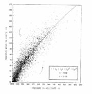
Inaccuracies and omissions in existing data
Errors
HURDAT contains a number of errors which need to be corrected, such demonstrated by the outliers in the a pressure vs. wind speed graph of datapoints in the database (right). Some of these errors have existed since the database's creation during NASANASA
The National Aeronautics and Space Administration is the agency of the United States government that is responsible for the nation's civilian space program and for aeronautics and aerospace research...
's Apollo Program, where it was used to help produce probabilities of tropical cyclone-induced winds in critical areas such as Cape Kennedy (now Cape Canaveral
Cape Canaveral
Cape Canaveral, from the Spanish Cabo Cañaveral, is a headland in Brevard County, Florida, United States, near the center of the state's Atlantic coast. Known as Cape Kennedy from 1963 to 1973, it lies east of Merritt Island, separated from it by the Banana River.It is part of a region known as the...
).
New information
A significant amount of new data for systems between 1851 and 1886 became available after a major basin-wide reanalysis in 1996, a project led by Jose Fernandez-Paratagas with the collaboration of Henry Diaz. The new data was constructed using old newspaper articles and the hemispheric weather mapSurface weather analysis
Surface weather analysis is a special type of weather map that provides a view of weather elements over a geographical area at a specified time based on information from ground-based weather stations...
series. Hurricane histories for individual states had been constructed by the 1990s as well, which proposed new storms and increased the knowledge of tropical cyclones already in the database. Due to this profusion of relevant information not included in HURDAT, and evolving definitions for tropical
Tropical cyclone
A tropical cyclone is a storm system characterized by a large low-pressure center and numerous thunderstorms that produce strong winds and heavy rain. Tropical cyclones strengthen when water evaporated from the ocean is released as the saturated air rises, resulting in condensation of water vapor...
and subtropical cyclone
Subtropical cyclone
A subtropical cyclone is a weather system that has some characteristics of a tropical and an extratropical cyclone. As early as the 1950s, meteorologists were unclear whether they should be characterized as tropical or extratropical cyclones. They were officially recognized by the National...
s over the decades, the project was started around 2000 to update the official database. Since then, the International Comprehensive Ocean-Atmosphere Data Set has been utilized to check for older ship reports which were either not utilized nor available to previous researchers.
Incompleteness of dataset
As early as 1957, it was recognized that an increasing trend in the number of tropical cyclones each season in the Atlantic Basin was at least partially tied to increasing observations and better records. By analyzing the density of ship tracks over time, it has been estimated that between 1900 and 1966, an average of two storms per year are missing from HURDAT. This is mainly due to a lack of satellite imagery and lack of reconnaissance aircraft prior to 1943. An additional storm per year is likely missing prior to the advent of new technologies. These technologies include satellite-derived QuikscatQuikSCAT
The QuikSCAT is an earth-observing satellite that provided estimates of wind speed and direction over the oceans to National Oceanic and Atmospheric Administration and others. This "quick recovery" mission intended to replace the NASA Scatterometer , which failed in June 1997...
winds, satellite-derived temperature profile information, and Robert Hart's cyclone phase space diagrams, which have led to a recent increase in tropical cyclone detection. Quikscat was launched in 1999, and has been credited with allowing Chantal to be named during the 2007 Atlantic hurricane season
2007 Atlantic hurricane season
The 2007 Atlantic hurricane season was an active Atlantic hurricane season that produced 17 tropical cyclones, 15 tropical storms, six hurricanes, and two major hurricanes. It officially started on June 1 and ended on November 30, dates which conventionally delimit the...
. The last two help determine whether or not a low pressure area
Low pressure area
A low-pressure area, or "low", is a region where the atmospheric pressure at sea level is below that of surrounding locations. Low-pressure systems form under areas of wind divergence which occur in upper levels of the troposphere. The formation process of a low-pressure area is known as...
is an extratropical cyclone
Extratropical cyclone
Extratropical cyclones, sometimes called mid-latitude cyclones or wave cyclones, are a group of cyclones defined as synoptic scale low pressure weather systems that occur in the middle latitudes of the Earth having neither tropical nor polar characteristics, and are connected with fronts and...
, subtropical cyclone
Subtropical cyclone
A subtropical cyclone is a weather system that has some characteristics of a tropical and an extratropical cyclone. As early as the 1950s, meteorologists were unclear whether they should be characterized as tropical or extratropical cyclones. They were officially recognized by the National...
, or tropical cyclone.
Christopher Landsea
Christopher Landsea
Christopher W. Landsea is an American meteorologist, formerly a research meteorologist with Hurricane Research Division of Atlantic Oceanographic & Meteorological Laboratory at NOAA, and now the Science and Operations Officer at the National Hurricane Center...
noted that the efforts to reanalyze the Atlantic hurricane database “will not be able to recover observations of open ocean tropical cyclones that were just never taken. Researchers cannot assume that the Atlantic tropical cyclone database presents a complete depiction of frequency of events before the advent of satellite imagery in the mid-1960s. Moreover, newly available advanced tools and techniques are also contributing toward monitoring about one additional Atlantic tropical cyclone per year since 2002. Thus large, long-term ‘trends’ in tropical cyclone frequency are primarily manifestations of increased monitoring capabilities and likely not related to any real change in the climate in which they develop.”
Progress
- In 2001, data for the years 1851-1885 were added to the official database from the Fernandez-Partagas series of publications. Also, a paleotempestology conference was held at the University of South CarolinaUniversity of South CarolinaThe University of South Carolina is a public, co-educational research university located in Columbia, South Carolina, United States, with 7 surrounding satellite campuses. Its historic campus covers over in downtown Columbia not far from the South Carolina State House...
which proposed to increase the scope of HURDAT from a starting year of 1851 to a start of 1800. The conference also discussed ways of exchanging information for the inclusion of older tropical cycloneTropical cycloneA tropical cyclone is a storm system characterized by a large low-pressure center and numerous thunderstorms that produce strong winds and heavy rain. Tropical cyclones strengthen when water evaporated from the ocean is released as the saturated air rises, resulting in condensation of water vapor...
s, such as via compact discCompact DiscThe Compact Disc is an optical disc used to store digital data. It was originally developed to store and playback sound recordings exclusively, but later expanded to encompass data storage , write-once audio and data storage , rewritable media , Video Compact Discs , Super Video Compact Discs ,...
or a WikipediaWikipediaWikipedia is a free, web-based, collaborative, multilingual encyclopedia project supported by the non-profit Wikimedia Foundation. Its 20 million articles have been written collaboratively by volunteers around the world. Almost all of its articles can be edited by anyone with access to the site,...
-style website. - In 2002, for the tenth anniversary of Hurricane AndrewHurricane AndrewHurricane Andrew was the third Category 5 hurricane to make landfall in the United States, after the Labor Day Hurricane of 1935 and Hurricane Camille in 1969. Andrew was the first named storm and only major hurricane of the otherwise inactive 1992 Atlantic hurricane season...
, the reanalysis was completed for the hurricane, which upgraded the cyclone to a Category 5Saffir-Simpson Hurricane ScaleThe Saffir–Simpson Hurricane Scale , or the Saffir–Simpson Hurricane Wind Scale , classifies hurricanes — Western Hemisphere tropical cyclones that exceed the intensities of tropical depressions and tropical storms — into five categories distinguished by the intensities of their sustained winds...
hurricane.
- In 2003, changes suggested by various sources for 1886 to 1910 were approved for the official HURDAT. Work by Michael Chenoweth, in collaboration with Cary Mock, increased knowledge of tropical cyclones in the Caribbean SeaCaribbean SeaThe Caribbean Sea is a sea of the Atlantic Ocean located in the tropics of the Western hemisphere. It is bounded by Mexico and Central America to the west and southwest, to the north by the Greater Antilles, and to the east by the Lesser Antilles....
for 1750 to 1786. (from The 18th Century ClimateClimateClimate encompasses the statistics of temperature, humidity, atmospheric pressure, wind, rainfall, atmospheric particle count and other meteorological elemental measurements in a given region over long periods...
of JamaicaJamaicaJamaica is an island nation of the Greater Antilles, in length, up to in width and 10,990 square kilometres in area. It is situated in the Caribbean Sea, about south of Cuba, and west of Hispaniola, the island harbouring the nation-states Haiti and the Dominican Republic...
) - In 2004, additional corrections for the years 1851 through 1910 were included into the database.
- In 2005, changes and additions were made for 1911 to 1914. Michael Chenoweth completed a basin-wide reassessment for old source material from the 1700 to 1855 period by using surface weather observationSurface weather observationSurface weather observations are the fundamental data used for safety as well as climatological reasons to forecast weather and issue warnings worldwide. They can be taken manually, by a weather observer, by computer through the use of automated weather stations, or in a hybrid scheme using...
s mainly in the form of ship reports, newspapers, and various diaries and journals from the region around the Caribbean SeaCaribbean SeaThe Caribbean Sea is a sea of the Atlantic Ocean located in the tropics of the Western hemisphere. It is bounded by Mexico and Central America to the west and southwest, to the north by the Greater Antilles, and to the east by the Lesser Antilles....
. - In 2006, four typographical errors were found and corrected in the 1851-1914 time period.
- In 2008, revisions were completed from 1915 through 1920.
- In 2009, revisions were completed from 1921 through 1925.
- In 2010, revisions were completed from 1926 through 1930.
Future plans
- The years 1911 - 1940 by Spring 2005
- The years 1941 - 1970 by Spring 2006
- The years 1971 - 1999 by Spring 2007
By Spring 2008, plans called for investigating trends in the new database and relationship between the statistics and the Atlantic Multidecadal Oscillation
Atlantic Multidecadal Oscillation
The Atlantic multidecadal oscillation is a mode of variability occurring in the North Atlantic Ocean and which has its principal expression in the sea surface temperature field...
and global climate change
Climate change
Climate change is a significant and lasting change in the statistical distribution of weather patterns over periods ranging from decades to millions of years. It may be a change in average weather conditions or the distribution of events around that average...
. If this plan were followed, accounting for the six year delay, the project will have taken fifteen years to complete, with the effort of dozens of scientists from multiple disciplines, such as meteorology
Meteorology
Meteorology is the interdisciplinary scientific study of the atmosphere. Studies in the field stretch back millennia, though significant progress in meteorology did not occur until the 18th century. The 19th century saw breakthroughs occur after observing networks developed across several countries...
, geography
Geography
Geography is the science that studies the lands, features, inhabitants, and phenomena of Earth. A literal translation would be "to describe or write about the Earth". The first person to use the word "geography" was Eratosthenes...
, archaeology
Archaeology
Archaeology, or archeology , is the study of human society, primarily through the recovery and analysis of the material culture and environmental data that they have left behind, which includes artifacts, architecture, biofacts and cultural landscapes...
, and climatology
Climatology
Climatology is the study of climate, scientifically defined as weather conditions averaged over a period of time, and is a branch of the atmospheric sciences...
.
Future efforts in other basins
There is agreement within tropical cycloneTropical cyclone
A tropical cyclone is a storm system characterized by a large low-pressure center and numerous thunderstorms that produce strong winds and heavy rain. Tropical cyclones strengthen when water evaporated from the ocean is released as the saturated air rises, resulting in condensation of water vapor...
circles of doing an "Atlantic-style" reanalysis for other ocean basins. Some efforts are underway to start similar reanalyses across the Pacific Ocean
Pacific Ocean
The Pacific Ocean is the largest of the Earth's oceanic divisions. It extends from the Arctic in the north to the Southern Ocean in the south, bounded by Asia and Australia in the west, and the Americas in the east.At 165.2 million square kilometres in area, this largest division of the World...
, but are likely to take longer to complete. This is due to the need for coordination between the multiple Regional Specialized Meteorological Centre
Regional Specialized Meteorological Centre
A Regional Specialized Meteorological Centre is responsible for the distribution of information, advisories, and warnings regarding the specific program they have a part of, agreed by consensus at the World Meteorological Organization as part of the World Weather Watch.-Tropical...
s, which have the responsibility for tracking and forecasting tropical cyclones across that ocean. These tropical cyclone reanalyses are important, as theories concerning climate change
Climate change
Climate change is a significant and lasting change in the statistical distribution of weather patterns over periods ranging from decades to millions of years. It may be a change in average weather conditions or the distribution of events around that average...
and tropical cyclone
Tropical cyclone
A tropical cyclone is a storm system characterized by a large low-pressure center and numerous thunderstorms that produce strong winds and heavy rain. Tropical cyclones strengthen when water evaporated from the ocean is released as the saturated air rises, resulting in condensation of water vapor...
trends hinge upon the quality of these databases.
See also
- HURDATHURDATThe North Atlantic hurricane database, or HURDAT, is the database for all tropical cyclones in the Atlantic Ocean, Gulf of Mexico and Caribbean Sea, since 1851.-History:...
(online database) - List of tropical cyclones
Books
- Michael Chenoweth. The 18th Century Climate of Jamaica. American Philosophical Society: Philadelphia, 2003.