
Waterfall Gully, South Australia
Encyclopedia
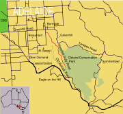
Waterfall Gully is an outer suburb of the South Australia
n capital city of Adelaide
. It is located in the foothills
of the Mount Lofty Ranges
around 5 km (3.1 mi) east-south-east of Adelaide's central business district
(CBD). For the most part, the suburb encompasses one long gully
with First Creek at its centre and Waterfall Gully Road running adjacent to the creek. At the southern end of the gully is First Falls, the waterfall
for which the suburb was named. Part of the City of Burnside
, Waterfall Gully is bounded to the north by the suburb of Burnside
, from the north-east to south-east by Cleland Conservation Park
(part of the suburb of Greenhill
), to the south by Crafers West
, and to the west by Leawood Gardens
and Mount Osmond
.
Historically, Waterfall Gully was first explored by European settlers in the early-to-mid-19th century, and quickly became a popular location for tourists and picnickers. The government chose to retain control over portions of Waterfall Gully until 1884, when they agreed to place the land under the auspices of the City of Burnside. 28 years later the government took back the management of the southern part of Waterfall Gully, designating it as South Australia's first National Pleasure Resort. Today this area remains under State Government
control, and in 1972 the Waterfall Gully Reserve, as it was then known, became part of the larger Cleland Conservation Park.
Over the years Waterfall Gully has been extensively logged, and early agricultural interests saw the cultivation of a variety of introduced species as crops, along with the development of local market garden
s and nurseries
. Attempts to mine
the area were largely unsuccessful, but the region housed one of the state's earliest water-powered mill
s, and a weir
erected in the early 1880s provided for part of the City of Burnside's water supply. Today the suburb consists primarily of private residences and parks.
, which encompass Waterfall Gully, was first sighted by Captain Matthew Flinders
in 1802. The gully itself was discovered soon after the establishment of Adelaide, and Colonel William Light
, the first Surveyor-General of the new colony, was said to have "decided on the site for Adelaide when viewing the plains from the hills near Waterfall Gully". Nevertheless, the gully had seen human visitors long before the arrival of the Europeans, as the native population had lived in the area for up to 40,000 years prior to Flinders' appearance off the South Australian coast.
and Mount Bonython
, and the region was referred to as Yur-e-billa, or "the place of the ears". The name of the Greater Mount Lofty Parklands, Yurrebilla, was derived from this term, while the nearby town of Uraidla
employs a more corrupted form.
Although Hardy states that the Kaurna people did not live in the ranges themselves, they did live on the lower slopes. An early settler of the neighbouring suburb of Beaumont
, James Milne Young, described the local Kaurnas: "At every creek and gully you would see their wurlies
[simple Aboriginal homes made out of twigs and grass] and their fires at night ... often as many as 500 to 600 would be camped in various places ... some behind the Botanic Gardens on the banks of the river; some toward the Ranges; some on the Waterfall Gully." Their main presence, demarcated by the use of fire against purchasers of land, was on the River Torrens
and the creeks that flowed into it, including Waterfall Gully's First Creek.
The land around Waterfall Gully provided the original inhabitants with a number of resources. The bark from the local stringybark
trees (Eucalyptus obliqua
) was used in the construction of winter huts, and stones and native timbers were used to form tools. Food was also present, and cossid moth larvae
along with other species of plants and animals were collected. Nevertheless, there were only a few resources that could only be found on the slopes, and "both hunting and food gathering would in general have been easier on the rich plains".
 One of the earliest accounts of Waterfall Gully comes from a "Mr Kent" who, along with Captain Collet Barker
and Barker's servant, Miles, climbed Mount Lofty in 1831. In making their ascent the party skirted a ravine—described by Mr Kent as possessing "smooth and grassy sides"—which is believed by Anne Hardy to have been Waterfall Gully. Subsequent to Barker's ascent, the first settlers who were recorded as having climbed Mount Lofty were Bingham Hutchinson
and his servant, William Burt. The pair made three attempts to scale the mount before succeeding, and for their first attempt they attempted to traverse Waterfall Gully. The attempt was unsuccessful, but in July 1837, Hutchinson wrote about the gully though which they had travelled. Waterfall Gully he wrote, had proven difficult, as the plants were so thickly grown as to provide a significant barrier to their progress. Near the point of surrender, Hutchinson described how they were "agreeably surprised by seeing a wall of rock about fifty or sixty feet [fifteen to eighteen meters] high, which stretched across the ravine, and from the top of it leapt the brook which had so long been [their] companion". The brook was First Creek, and the waterfall they sighted is today known as First Falls.
Nevertheless, Hutchinson was not the first to see First Falls. The first known recorded sighting of the waterfall by a colonial was that of John William Adams, an emigrant of H.M.S. Buffalo
in early January 1837, who named it "Adams' Waterfall". He was traveling with his wife, Susanna and a party consisting of Nicholson's and Breaker's who had the use of a dray to go into the hills. Adams states "we were opposite the spot where the Eagle on the Hill now is, and the question was put, who would volunteer to go down the hillside to try for water".
on Mount Barker road. The position of the Eagle on the Hill hotel proved advantageous for this, as it permitted visitors to stop by for lunch before walking down the hill in the afternoon.
 Other parts of the Waterfall Gully area were subdivided, though, and much of the area was owned by Samuel Davenport
. Davenport used the land for timber, grazing, and the cultivation of various crops, including olives and grapes for wine production
. Other local residents ran market gardens and nurseries
. For example, local residents Wilhelm Mügge and his wife Auguste Schmidt operated "one of the best nurseries and market gardens near Adelaide", and gained a reputation for the cheeses produced from their local dairy farm. Along with farming, the hills and creek were prized areas for the sawyer
s and splitters, and a number of mines were established in the region from the mid-to-late 19th century. In 1844 the first silver-lead
, manganese
and iron
mines were established in the area, while the 1890s saw a minor gold rush—although "only small quantities were extracted". Of greater success was stone quarrying in Chambers' Gully, which began in 1863 and increased in scale in 1912.
Waterfall Gully was also the site of Burnside's "first secondary industry". In the late 1830s, Thomas Cain built a watermill
on First Creek for John Cannan, which was then employed to power a sawmill on Cannan's property. Cannan operated the mill as the "Traversbrook Mill" for approximately two years before selling the venture to a Mr. Finniss. Finniss opted to run the mill as a flour mill instead, and the mill was rebuilt and renamed "Finnissbrook Mill". The mill continued to operate under a variety of owners until the late 1850s, but it was dismantled during the 1880s, and today only traces of the earthworks remain.
 During this period the population of the nearby village of Burnside
was expanding and required a new water supply. First Creek—which runs down Waterfall Gully and enters the River Torrens near today's Botanic Gardens—was seen as the perfect solution to the water shortage. A weir
was built during 1881 and 1882, and was made to hold approximately two megalitres (530,000 US gallons) of water. A pipeline was constructed to the reservoir at Burnside South, and from there the water was used throughout the surrounding area. As a side effect, the weir also reduced the volume of water available to the local market gardeners, and over many years that aspect of the region disappeared.
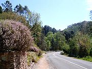
While the route to the falls from Eagle on the Hill was on public land, the alternative route along the gully was through private properties. Nevertheless, many visitors chose this route, and a combination of public demand and a desire from some of the landowners for improved access to and from their properties—especially from the Mügge family—led to pressure to build a road through the gully. Although there was opposition from some of the locals, the Waterfall Gully road was built in the late 1880s.
The completion of the road led to an increase in visitor numbers. Rather than a bumpy horse ride, visitors could now catch the horse tram
to the start of the gully, and walk, cycle or ride to the falls. To provide for tourists, the area gained a number of road-side kiosks and produce stalls, and the Mügge family erected the two story Waterfall Hotel along the path. Furthermore, in 1912 the government opened a kiosk at the base of First Falls, designed in the "style of a Swiss chalet". The hotel is a private residence today, but the kiosk continues to operate.
) to the City of Burnside in 1856 when the suburb's current boundaries were established, the government of the day chose to retain control of a significant portion of Waterfall Gully. Thus it was not until 1884 that the remaining land was transferred to the control of the Burnside Council, eventuating largely through the efforts of Samuel Davenport and G. F. Cleland.
The land remained under the Burnside Council's control until 1912, when the Waterfall Gully Reserve was reclaimed by the government as the first National Pleasure Resort in the state. Initially the reserve was placed under the jurisdiction of the National Parks Advisory Board, but later it was moved to the Tourist Bureau, before finally becoming part of the National Park Commission's portfolio.
In 1945, much of the area that is today's Cleland Conservation Park
was purchased by the State Government
, largely thanks to the efforts of Professor Sir John Cleland
. Most of this land was combined in 1963 to create the park that extends eastwards up the gully to the summit of Mount Lofty
and northwards to Greenhill Road. Waterfall Gully Reserve was added to the park in 1972.
 Over the years since European settlement Waterfall Gully has suffered from both bushfires and flooding. The gully was severely hit by a number of bushfires in 1939 that threatened the area, and further bushfires in the early 1940s caused considerable damage because of the war effort
diverting supplies and personnel from the Country Fire Service
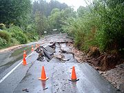
(CFS). Significant floods occurred in 1889 and 1931, and, on the night of 7 November 2005, Waterfall Gully was one of several areas in Adelaide to experience severe flooding. Waterfall Gully was one of the hardest hit suburbs: Bob Stevenson, Duty Officer of the State Emergency Service
(SES), commented that "There's an area called Waterfall Gully Road, in the foothills, where one of the creeks comes down, and there's quite a few houses affected there ... there was 40 or so houses affected on that one road alone." Properties were flooded, two bridges nearly collapsed, and 100 m (328.1 ft) of road was washed away. Burnside council workers, the CFS and the SES repaired the initial damage on the night while reconstruction of infrastructure commenced in late November. Much of the road had been inaccessible, and the suburb was closed except to residents and emergency workers for the remainder of the month.
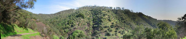
 Waterfall Gully is situated at an average elevation of 234 m (767.7 ft) above sea level, in an area of 6.08 km² (2.3 sq mi). Its most notable geographical features are its gully and waterfall. Langman Reserve, a large local park, is 300 m (984.3 ft) from the start of Waterfall Gully Road while much of the north-eastern side of the gully is part of Cleland Conservation Park. Adjoining Waterfall Gully, 2 km (1.2 mi) away, is Chambers Gully, which used to function as a land-fill
, but has in the past decade been reclaimed as a park through volunteer work. It contains a number of old ruins, walking trails, and springs and is home to a significant number of native species.
Since European Settlement the native plant life has been considerably affected, with the native Manna Gum
and Blue Gum
woodlands being largely cleared for agricultural uses. The large amount of non-native vegetation in the gully is predominantly the result of the early agriculture, although some species were introduced by accident. Introduced species include olive trees, hawthorn
, fennel
and blackberry. With the reduction of native flora, exotic fauna have flourished around the Waterfall Gully region. These include rabbits, blackbirds and starling
s. However, not all of the native wildlife has been lost—bats (in particular, Gould's Wattled Bat
), can be found in the area, as can Superb Fairy-wren
s and Adelaide Rosellas, and a large number of unique Australian animals
such as kangaroos, koalas and possum
s can be spotted on some of the walking trails.
 Waterfall Gully is connected to the major Adelaide thoroughfare Greenhill Road by Waterfall Terrace and Glynburn Road, and cars are the preferred mode of transport in the suburb. According to the Australian Bureau of Statistics
71.9% of residents in the census area employed private vehicles for their commute to work. Only a small proportion (1.3%) walked to work and but 1.2% cycled, while only 3.6% of Waterfall Gully residents travel to work by bus. The closest bus route for Waterfall Gully is the 142 bus, provided by the multi-service Adelaide Metro
.
Waterfall Gully Road is meandering and in some parts quite narrow. This has led to concerns regarding safety, as the road is frequented by both pedestrians and cyclists. After the death of a cyclist in 2007, calls for the repair and resurfacing of the road intensified, with two petitions being tabled in parliament. The accident also led to a safety audit being conducted by TransportSA, and although the results were not released to the public at the time, it called for an investigation of the entire length of the road. As of mid-2008, there has been no clear plan released for the future of the road, with the road missing out on funding in the 2008 state budget.
 In the 2001 Census, the population of the Waterfall Gully census area (which includes the suburbs of Glen Osmond
, Leawood Gardens
and Mount Osmond
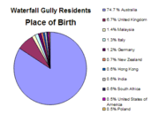
) was 2,497 people, in an area of 6.08 square kilometers. Females outnumbered males 54.2% to 45.8%, and some 21.4% of the population was born overseas (see chart for a breakdown). There was only a slight change in the 2006 census, with the population increasing by 25 to 2,522.
The eight strongest religious affiliations in the area (based on the 2006 census figures) were (in descending order): Anglican, Catholic, Uniting
, Lutheran
, Orthodox Christian
, Buddhist
, Presbyterian, Church of Christ
and Baptist
(a combination of other Christian faiths came in somewhere between Presbyterians and the Church of Christ, with 31 adherents). Also of note is the high occurrence of religious affiliation (67.3%) in the region in comparison to the Adelaide (and national) average. Christian belief (64.4%) is most prominent, with little growth in other religions.
Residents in these four suburbs are more affluent than the Adelaide average, with a high occurrence of incomes over A$
1000 per week, which is also above the average for the City of Burnside. A majority of workers are employed in professional or white collar fields.
The census area that incorporates Waterfall Gully has a larger proportion of those in both the younger (0–17) and older (60+) age ranges than in the City of Burnside as a whole, and there have been no "numerically significant" changes in the age distribution between the 2001 and 2006 censuses. Similarly, family numbers are also stable, with almost no change between 2001 and 2006.
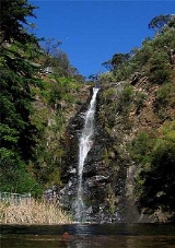
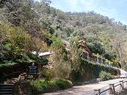 The main attraction of Waterfall Gully is the waterfall, First Falls. It is at the south-eastern end of the road, in land owned by Cleland Conservation Park. The weir at the bottom of the Waterfall was constructed in the late 19th century and was part of Adelaide's early water supply. Development in the area has continued since the construction of a restaurant in 1912. Developments over recent decades have included improving access to the site, upgrading the bridges, and the addition of new signage.
The Waterfall Gully Restaurant was constructed between 1911 and 1912 by South Australian architects Albert Selmar Conrad and his brother Frank, and was formally opened by Sir Day Bosanquet
on 9 November 1912. Built in the style of a Swiss chalet, the building has been heritage listed since 1987, and is reputedly haunted by the ghost of a firefighter who died from burns suffered in 1926.
Other fire tracks and walking trails wind around the hills that surround Waterfall Gully, branching off from Chambers Gully, Woolshed Gully or the area around First Creek. Destinations include Crafers
, Eagle On The Hill
, Mount Lofty, Mount Osmond and the Cleland Wildlife Park, located in the Cleland Conservation Park. The tracks have been completely rebuilt and resurfaced in the past ten years, and a number of older and more perilous routes have been sealed because of the difficult terrain. Many offer views of the city of Adelaide as well as the Gully itself. One of these is notable for connecting to the 1200 km (745.6 mi) Heysen Trail
, and the trails are highly frequented.
Waterfall Gully is part of the state electoral district of Bragg, which has been held since 2002 by Liberal MP Vickie Chapman
. In federal politics, the suburb is part of the division of Sturt
, and has been represented by Christopher Pyne
since 1993. The results shown are from the closest polling station to Waterfall Gully—which is located outside of the suburb—at St David's Church Hall on nearby Glynburn Road (Burnside
). Both electorates have traditionally gone to the Liberal Party
, and Bragg in particular is regarded as a very safe Liberal seat. However, in the 2007 federal election, a strong swing towards the Labor Party
and their candidate, Mia Handshin
, resulted in the electorate transforming from a "safe [federal] Liberal seat into a marginal one".
In local government
, Waterfall Gully is part of the ward of Beaumont within the City of Burnside, and the current Mayor for the district is David Parkin. Beaumont is currently represented by councilors Mark Osterstock and Anne Monceaux.
South Australia
South Australia is a state of Australia in the southern central part of the country. It covers some of the most arid parts of the continent; with a total land area of , it is the fourth largest of Australia's six states and two territories.South Australia shares borders with all of the mainland...
n capital city of Adelaide
Adelaide
Adelaide is the capital city of South Australia and the fifth-largest city in Australia. Adelaide has an estimated population of more than 1.2 million...
. It is located in the foothills
Adelaide Hills
The Adelaide Hills are part of the Mount Lofty Ranges, east of the city of Adelaide in the state of South Australia. It is unofficially centred on the largest town in the area, Mount Barker, which has a population of around 29,000 and is also one of Australia's fastest growing towns.- History :The...
of the Mount Lofty Ranges
Mount Lofty Ranges
The Mount Lofty Ranges are the range of mountains just to the east of Adelaide in South Australia.-Location and description:The Mount Lofty Ranges stretch from the southernmost point of the Fleurieu Peninsula at Cape Jervis northwards for over before petering out north of Peterborough...
around 5 km (3.1 mi) east-south-east of Adelaide's central business district
Central business district
A central business district is the commercial and often geographic heart of a city. In North America this part of a city is commonly referred to as "downtown" or "city center"...
(CBD). For the most part, the suburb encompasses one long gully
Gully
A gully is a landform created by running water, eroding sharply into soil, typically on a hillside. Gullies resemble large ditches or small valleys, but are metres to tens of metres in depth and width...
with First Creek at its centre and Waterfall Gully Road running adjacent to the creek. At the southern end of the gully is First Falls, the waterfall
Waterfall
A waterfall is a place where flowing water rapidly drops in elevation as it flows over a steep region or a cliff.-Formation:Waterfalls are commonly formed when a river is young. At these times the channel is often narrow and deep. When the river courses over resistant bedrock, erosion happens...
for which the suburb was named. Part of the City of Burnside
City of Burnside
The City of Burnside is a local government area with an estimated population of 44,300 people in the South Australian city of Adelaide. Burnside was founded in August 1856 as the District Council of Burnside, and was classed as a city in 1943. It is named after the property of an early settler and...
, Waterfall Gully is bounded to the north by the suburb of Burnside
Burnside, South Australia
Burnside is a small suburb that is part of the City of Burnside in the eastern suburbs of Adelaide. It is primarily a residential suburb, and was one of the first suburbs of Adelaide...
, from the north-east to south-east by Cleland Conservation Park
Cleland Conservation Park
Cleland Conservation Park is a conservation park in the Adelaide Hills, South Australia. from Adelaide City centre. Cleland Conservation Park conserves a significant area of natural bushland on the Adelaide Hills face and includes the internationally popular Cleland Wildlife Park and the popular...
(part of the suburb of Greenhill
Greenhill, South Australia
Greenhill is a suburb of Adelaide located in the foothills of the Adelaide Hills either side of Greenhill Road. Adjacent suburbs are Waterfall Gully, Burnside, Stonyfell, Skye, Norton Summit, Summertown and Ashton, and includes Cleland Conservation Park and the western slopes and summit of Mount...
), to the south by Crafers West
Crafers West, South Australia
-References:...
, and to the west by Leawood Gardens
Leawood Gardens, South Australia
Leawood Gardens is a small suburb of Adelaide, South Australia in both the City of Mitcham and the City of Burnside located in the foothills of the Adelaide Hills....
and Mount Osmond
Mount Osmond, South Australia
Mount Osmond is a small suburb of 2,497 people in the South Australian capital city of Adelaide. It is part of the City of Burnside Local Government Area and located in the foothills of the Adelaide Hills, five kilometres south east of the city centre...
.
Historically, Waterfall Gully was first explored by European settlers in the early-to-mid-19th century, and quickly became a popular location for tourists and picnickers. The government chose to retain control over portions of Waterfall Gully until 1884, when they agreed to place the land under the auspices of the City of Burnside. 28 years later the government took back the management of the southern part of Waterfall Gully, designating it as South Australia's first National Pleasure Resort. Today this area remains under State Government
Government of South Australia
The form of the Government of South Australia is prescribed in its constitution, which dates from 1856, although it has been amended many times since then...
control, and in 1972 the Waterfall Gully Reserve, as it was then known, became part of the larger Cleland Conservation Park.
Over the years Waterfall Gully has been extensively logged, and early agricultural interests saw the cultivation of a variety of introduced species as crops, along with the development of local market garden
Market gardening
A market garden is the relatively small-scale production of fruits, vegetables and flowers as cash crops, frequently sold directly to consumers and restaurants. It is distinguishable from other types of farming by the diversity of crops grown on a small area of land, typically, from under one acre ...
s and nurseries
Nursery (horticulture)
A nursery is a place where plants are propagated and grown to usable size. They include retail nurseries which sell to the general public, wholesale nurseries which sell only to businesses such as other nurseries and to commercial gardeners, and private nurseries which supply the needs of...
. Attempts to mine
Mining
Mining is the extraction of valuable minerals or other geological materials from the earth, from an ore body, vein or seam. The term also includes the removal of soil. Materials recovered by mining include base metals, precious metals, iron, uranium, coal, diamonds, limestone, oil shale, rock...
the area were largely unsuccessful, but the region housed one of the state's earliest water-powered mill
Watermill
A watermill is a structure that uses a water wheel or turbine to drive a mechanical process such as flour, lumber or textile production, or metal shaping .- History :...
s, and a weir
Weir
A weir is a small overflow dam used to alter the flow characteristics of a river or stream. In most cases weirs take the form of a barrier across the river that causes water to pool behind the structure , but allows water to flow over the top...
erected in the early 1880s provided for part of the City of Burnside's water supply. Today the suburb consists primarily of private residences and parks.
History
The Mount Lofty RangesMount Lofty Ranges
The Mount Lofty Ranges are the range of mountains just to the east of Adelaide in South Australia.-Location and description:The Mount Lofty Ranges stretch from the southernmost point of the Fleurieu Peninsula at Cape Jervis northwards for over before petering out north of Peterborough...
, which encompass Waterfall Gully, was first sighted by Captain Matthew Flinders
Matthew Flinders
Captain Matthew Flinders RN was one of the most successful navigators and cartographers of his age. In a career that spanned just over twenty years, he sailed with Captain William Bligh, circumnavigated Australia and encouraged the use of that name for the continent, which had previously been...
in 1802. The gully itself was discovered soon after the establishment of Adelaide, and Colonel William Light
William Light
Colonel William Light was a British military officer and the first Surveyor-General of the Colony of South Australia...
, the first Surveyor-General of the new colony, was said to have "decided on the site for Adelaide when viewing the plains from the hills near Waterfall Gully". Nevertheless, the gully had seen human visitors long before the arrival of the Europeans, as the native population had lived in the area for up to 40,000 years prior to Flinders' appearance off the South Australian coast.
Ethnohistory
In Australian Aboriginal mythology, Waterfall Gully and the surrounding Mount Lofty Ranges are part of the story of the ancestor-creator Nganno. Travelling across the land of the native Kaurna people, Nganno was wounded in a battle and laid down to die, forming the Mount Lofty Ranges. The ears of Nganno formed the peaks of Mount LoftyMount Lofty
Mount Lofty is the highest point in the Mount Lofty Ranges. It is located about 15km east of the centre of the city of Adelaide in South Australia and gives unrivalled panoramic views of the city and the Adelaide plains and foothills. It was first climbed by a European when explorer Collet Barker...
and Mount Bonython
Mount Bonython
Mount Bonython is one of two major peaks in the Adelaide hills visible from Adelaide. The other, about a kilometre to the south and some 20 m higher, is Mount Lofty...
, and the region was referred to as Yur-e-billa, or "the place of the ears". The name of the Greater Mount Lofty Parklands, Yurrebilla, was derived from this term, while the nearby town of Uraidla
Uraidla, South Australia
Uraidla is a small town in the Adelaide Hills of South Australia, Australia. At the 2006 census, Uraidla had a population of 461.-History:Once the home of the Peramangk Aboriginal people, European settlement commenced in the mid nineteenth century, a primary school opened in 1871 and the town was...
employs a more corrupted form.
Although Hardy states that the Kaurna people did not live in the ranges themselves, they did live on the lower slopes. An early settler of the neighbouring suburb of Beaumont
Beaumont, South Australia
Beaumont is a suburb of Adelaide in the City of Burnside. Founded as a purpose-built village by Sir Samuel Davenport in 1848, it initially struggled due to high land prices in the area. However, with Adelaide's inevitable expansion residents eventually settled...
, James Milne Young, described the local Kaurnas: "At every creek and gully you would see their wurlies
Hump
Hump may refer to:* HUMP! , an annual presentation of amateur pornography* The Hump, a name given by WWII Allied pilots to part of the Himalayan mountains* Kyphosis, the curve on an upper spine that causes a hunchback* Speed hump...
[simple Aboriginal homes made out of twigs and grass] and their fires at night ... often as many as 500 to 600 would be camped in various places ... some behind the Botanic Gardens on the banks of the river; some toward the Ranges; some on the Waterfall Gully." Their main presence, demarcated by the use of fire against purchasers of land, was on the River Torrens
River Torrens
The River Torrens is the most significant river of the Adelaide Plains and was one of the reasons for the siting of the city of Adelaide, capital of South Australia. It flows from its source in the Adelaide Hills near Mount Pleasant, across the Adelaide Plains, past the city centre and empties...
and the creeks that flowed into it, including Waterfall Gully's First Creek.
The land around Waterfall Gully provided the original inhabitants with a number of resources. The bark from the local stringybark
Stringybark
A stringybark can be any of the many Eucalyptus species which have thick, fibrous bark. Like all eucalypts, stringybarks belong to the Myrtaceae family. In exceptionally fertile locations some stringybark species A stringybark can be any of the many Eucalyptus species which have thick, fibrous...
trees (Eucalyptus obliqua
Eucalyptus obliqua
Eucalyptus obliqua, commonly known as Australian Oak, Brown Top, Brown Top Stringbark, Messmate, Messmate Stringybark, Stringybark and Tasmanian Oak, is a hardwood tree native to south-eastern Australia....
) was used in the construction of winter huts, and stones and native timbers were used to form tools. Food was also present, and cossid moth larvae
Witchetty grub
The witchetty grub is a term used in Australia for the large, white, wood-eating larvae of several moths...
along with other species of plants and animals were collected. Nevertheless, there were only a few resources that could only be found on the slopes, and "both hunting and food gathering would in general have been easier on the rich plains".
Early colonial exploration
Collet Barker
Collet Barker was a British military officer and explorer. He explored areas of South Australia, Western Australia and Cobourg Peninsula, Northern Territory-History:Barker was born in Hackney, he lived in Newbury as a child...
and Barker's servant, Miles, climbed Mount Lofty in 1831. In making their ascent the party skirted a ravine—described by Mr Kent as possessing "smooth and grassy sides"—which is believed by Anne Hardy to have been Waterfall Gully. Subsequent to Barker's ascent, the first settlers who were recorded as having climbed Mount Lofty were Bingham Hutchinson
Young Bingham Hutchinson
Young Bingham Hutchinson was a Royal Navy officer, early explorer and settler of South Australia....
and his servant, William Burt. The pair made three attempts to scale the mount before succeeding, and for their first attempt they attempted to traverse Waterfall Gully. The attempt was unsuccessful, but in July 1837, Hutchinson wrote about the gully though which they had travelled. Waterfall Gully he wrote, had proven difficult, as the plants were so thickly grown as to provide a significant barrier to their progress. Near the point of surrender, Hutchinson described how they were "agreeably surprised by seeing a wall of rock about fifty or sixty feet [fifteen to eighteen meters] high, which stretched across the ravine, and from the top of it leapt the brook which had so long been [their] companion". The brook was First Creek, and the waterfall they sighted is today known as First Falls.
Nevertheless, Hutchinson was not the first to see First Falls. The first known recorded sighting of the waterfall by a colonial was that of John William Adams, an emigrant of H.M.S. Buffalo
HMS Buffalo (1813)
HMS Buffalo was a storeship of the Royal Navy, originally built in India as the merchant vessel Hindostan. She later served as a convict ship and as transport for immigrants to Australia before being wrecked in 1840.-Launch and purchase:...
in early January 1837, who named it "Adams' Waterfall". He was traveling with his wife, Susanna and a party consisting of Nicholson's and Breaker's who had the use of a dray to go into the hills. Adams states "we were opposite the spot where the Eagle on the Hill now is, and the question was put, who would volunteer to go down the hillside to try for water".
Development
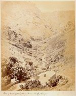
The area soon became a tourist attraction for the early South Australian colonists, and was a popular destination for picnickers. In 1851 Francis Clark wrote that "Waterfall Gully is the most picturesque place for a picnic that I have ever visited", and by the 1860s the area had become known throughout Adelaide. The use of Waterfall Gully as picnic spot was facilitated by the decision of the government of the day not to subdivide the area containing the waterfalls. Section 920, as it was designated, did not enter into private hands, and thus members of the public were able to access the area from the nearby suburb of Eagle on the HillEagle on the Hill, South Australia
Eagle On The Hill is an unbounded locality of Adelaide in the Adelaide Foothills. It borders Mount Osmond and Waterfall Gully.The village is located on Mount Barker Road, which was the only connection from Adelaide to the South Eastern Freeway. Once the Adelaide-Crafers Highway through the Heysen...
on Mount Barker road. The position of the Eagle on the Hill hotel proved advantageous for this, as it permitted visitors to stop by for lunch before walking down the hill in the afternoon.
Samuel Davenport
Sir Samuel Davenport KCMG was one of the early settlers of Australia and became a landowner and parliamentarian in South Australia....
. Davenport used the land for timber, grazing, and the cultivation of various crops, including olives and grapes for wine production
Winemaking
Winemaking, or vinification, is the production of wine, starting with selection of the grapes or other produce and ending with bottling the finished wine. Although most wine is made from grapes, it may also be made from other fruit or non-toxic plant material...
. Other local residents ran market gardens and nurseries
Nursery (horticulture)
A nursery is a place where plants are propagated and grown to usable size. They include retail nurseries which sell to the general public, wholesale nurseries which sell only to businesses such as other nurseries and to commercial gardeners, and private nurseries which supply the needs of...
. For example, local residents Wilhelm Mügge and his wife Auguste Schmidt operated "one of the best nurseries and market gardens near Adelaide", and gained a reputation for the cheeses produced from their local dairy farm. Along with farming, the hills and creek were prized areas for the sawyer
Lumberjack
A lumberjack is a worker in the logging industry who performs the initial harvesting and transport of trees for ultimate processing into forest products. The term usually refers to a bygone era when hand tools were used in harvesting trees principally from virgin forest...
s and splitters, and a number of mines were established in the region from the mid-to-late 19th century. In 1844 the first silver-lead
Silver mining
Silver mining refers to the resource extraction of the precious metal element silver by mining.-History:Silver has been known since ancient times. It is mentioned in the Book of Genesis, and slag heaps found in Asia Minor and on the islands of the Aegean Sea indicate that silver was being separated...
, manganese
Manganese
Manganese is a chemical element, designated by the symbol Mn. It has the atomic number 25. It is found as a free element in nature , and in many minerals...
and iron
Iron
Iron is a chemical element with the symbol Fe and atomic number 26. It is a metal in the first transition series. It is the most common element forming the planet Earth as a whole, forming much of Earth's outer and inner core. It is the fourth most common element in the Earth's crust...
mines were established in the area, while the 1890s saw a minor gold rush—although "only small quantities were extracted". Of greater success was stone quarrying in Chambers' Gully, which began in 1863 and increased in scale in 1912.
Waterfall Gully was also the site of Burnside's "first secondary industry". In the late 1830s, Thomas Cain built a watermill
Watermill
A watermill is a structure that uses a water wheel or turbine to drive a mechanical process such as flour, lumber or textile production, or metal shaping .- History :...
on First Creek for John Cannan, which was then employed to power a sawmill on Cannan's property. Cannan operated the mill as the "Traversbrook Mill" for approximately two years before selling the venture to a Mr. Finniss. Finniss opted to run the mill as a flour mill instead, and the mill was rebuilt and renamed "Finnissbrook Mill". The mill continued to operate under a variety of owners until the late 1850s, but it was dismantled during the 1880s, and today only traces of the earthworks remain.
Burnside, South Australia
Burnside is a small suburb that is part of the City of Burnside in the eastern suburbs of Adelaide. It is primarily a residential suburb, and was one of the first suburbs of Adelaide...
was expanding and required a new water supply. First Creek—which runs down Waterfall Gully and enters the River Torrens near today's Botanic Gardens—was seen as the perfect solution to the water shortage. A weir
Weir
A weir is a small overflow dam used to alter the flow characteristics of a river or stream. In most cases weirs take the form of a barrier across the river that causes water to pool behind the structure , but allows water to flow over the top...
was built during 1881 and 1882, and was made to hold approximately two megalitres (530,000 US gallons) of water. A pipeline was constructed to the reservoir at Burnside South, and from there the water was used throughout the surrounding area. As a side effect, the weir also reduced the volume of water available to the local market gardeners, and over many years that aspect of the region disappeared.
While the route to the falls from Eagle on the Hill was on public land, the alternative route along the gully was through private properties. Nevertheless, many visitors chose this route, and a combination of public demand and a desire from some of the landowners for improved access to and from their properties—especially from the Mügge family—led to pressure to build a road through the gully. Although there was opposition from some of the locals, the Waterfall Gully road was built in the late 1880s.
The completion of the road led to an increase in visitor numbers. Rather than a bumpy horse ride, visitors could now catch the horse tram
Horsecar
A horsecar or horse-drawn tram is an animal-powered streetcar or tram.These early forms of public transport developed out of industrial haulage routes that had long been in existence, and from the omnibus routes that first ran on public streets in the 1820s, using the newly improved iron or steel...
to the start of the gully, and walk, cycle or ride to the falls. To provide for tourists, the area gained a number of road-side kiosks and produce stalls, and the Mügge family erected the two story Waterfall Hotel along the path. Furthermore, in 1912 the government opened a kiosk at the base of First Falls, designed in the "style of a Swiss chalet". The hotel is a private residence today, but the kiosk continues to operate.
 |
 |
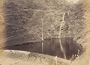
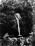
| In 1880, Second Falls was covered in lush ferns. Today the ferns have all but disappeared, and introduced species have taken their place. | |
Protection
Although some parts of Waterfall Gully were transferred from the District Council of East Torrens (now the Adelaide Hills CouncilAdelaide Hills Council
Adelaide Hills Council was established in 1997 by the amalgamation of four smaller district councils...
) to the City of Burnside in 1856 when the suburb's current boundaries were established, the government of the day chose to retain control of a significant portion of Waterfall Gully. Thus it was not until 1884 that the remaining land was transferred to the control of the Burnside Council, eventuating largely through the efforts of Samuel Davenport and G. F. Cleland.
The land remained under the Burnside Council's control until 1912, when the Waterfall Gully Reserve was reclaimed by the government as the first National Pleasure Resort in the state. Initially the reserve was placed under the jurisdiction of the National Parks Advisory Board, but later it was moved to the Tourist Bureau, before finally becoming part of the National Park Commission's portfolio.
In 1945, much of the area that is today's Cleland Conservation Park
Cleland Conservation Park
Cleland Conservation Park is a conservation park in the Adelaide Hills, South Australia. from Adelaide City centre. Cleland Conservation Park conserves a significant area of natural bushland on the Adelaide Hills face and includes the internationally popular Cleland Wildlife Park and the popular...
was purchased by the State Government
Government of South Australia
The form of the Government of South Australia is prescribed in its constitution, which dates from 1856, although it has been amended many times since then...
, largely thanks to the efforts of Professor Sir John Cleland
John Burton Cleland
Sir John Burton Cleland CBE was a renowned Australian naturalist, microbiologist, mycologist and ornithologist.-Early Life and education:...
. Most of this land was combined in 1963 to create the park that extends eastwards up the gully to the summit of Mount Lofty
Mount Lofty
Mount Lofty is the highest point in the Mount Lofty Ranges. It is located about 15km east of the centre of the city of Adelaide in South Australia and gives unrivalled panoramic views of the city and the Adelaide plains and foothills. It was first climbed by a European when explorer Collet Barker...
and northwards to Greenhill Road. Waterfall Gully Reserve was added to the park in 1972.
Natural disasters
World War II
World War II, or the Second World War , was a global conflict lasting from 1939 to 1945, involving most of the world's nations—including all of the great powers—eventually forming two opposing military alliances: the Allies and the Axis...
diverting supplies and personnel from the Country Fire Service
Country Fire Service
The SA Country Fire Service is a volunteer based fire service in the state of South Australia in Australia. Many parts of Australia are sparsely populated whilst at the same time they are under significant risk of bushfire. Due to economics, it is prohibitively expensive for each Australian town...
(CFS). Significant floods occurred in 1889 and 1931, and, on the night of 7 November 2005, Waterfall Gully was one of several areas in Adelaide to experience severe flooding. Waterfall Gully was one of the hardest hit suburbs: Bob Stevenson, Duty Officer of the State Emergency Service
State Emergency Service
A State Emergency Service is an Australian volunteer organisation that provides emergency help during and after declared disasters. The SES is also the primary or secondary agency for emergencies, such as storm damage,flood damage, building damage, traffic hazards and road crash rescue...
(SES), commented that "There's an area called Waterfall Gully Road, in the foothills, where one of the creeks comes down, and there's quite a few houses affected there ... there was 40 or so houses affected on that one road alone." Properties were flooded, two bridges nearly collapsed, and 100 m (328.1 ft) of road was washed away. Burnside council workers, the CFS and the SES repaired the initial damage on the night while reconstruction of infrastructure commenced in late November. Much of the road had been inaccessible, and the suburb was closed except to residents and emergency workers for the remainder of the month.
Geography
Landfill
A landfill site , is a site for the disposal of waste materials by burial and is the oldest form of waste treatment...
, but has in the past decade been reclaimed as a park through volunteer work. It contains a number of old ruins, walking trails, and springs and is home to a significant number of native species.
Since European Settlement the native plant life has been considerably affected, with the native Manna Gum
Manna Gum
Eucalyptus viminalis, Manna Gum, also known as White Gum, Ribbon Gum or Viminalis is an Australian eucalypt.It is a straight erect tree, often around 40 metres tall, with rough bark on the trunk and base of larger branches, its upper bark peels away in long "ribbons" which can collect on the...
and Blue Gum
Eucalyptus leucoxylon
Eucalyptus leucoxylon, commonly known as the Yellow Gum, Blue Gum or White Ironbark, is a small to medium-sized tree with rough bark on the lower 1-2 metres of the trunk, above this, the bark becomes smooth with a white, yellow or bluish-grey surface...
woodlands being largely cleared for agricultural uses. The large amount of non-native vegetation in the gully is predominantly the result of the early agriculture, although some species were introduced by accident. Introduced species include olive trees, hawthorn
Common Hawthorn
Crataegus monogyna, known as common hawthorn or single-seeded hawthorn, is a species of hawthorn native to Europe, northwest Africa and western Asia. It has been introduced in many other parts of the world where it is an invasive weed...
, fennel
Fennel
Fennel is a plant species in the genus Foeniculum . It is a member of the family Apiaceae . It is a hardy, perennial, umbelliferous herb, with yellow flowers and feathery leaves...
and blackberry. With the reduction of native flora, exotic fauna have flourished around the Waterfall Gully region. These include rabbits, blackbirds and starling
Starling
Starlings are small to medium-sized passerine birds in the family Sturnidae. The name "Sturnidae" comes from the Latin word for starling, sturnus. Many Asian species, particularly the larger ones, are called mynas, and many African species are known as glossy starlings because of their iridescent...
s. However, not all of the native wildlife has been lost—bats (in particular, Gould's Wattled Bat
Gould's Wattled Bat
Gould's Wattled Bat is a species of Australian wattled bat named after the English naturalist John Gould.-Range:C. gouldii is known throughout mainland Australia as well as Tasmania, New Caledonia, and Norfolk Island.-Appearance:C...
), can be found in the area, as can Superb Fairy-wren
Superb Fairy-wren
The Superb Fairywren , also known as the Superb Blue-wren or colloquially as the Blue Wren, is a passerine bird of the Maluridae family, common and familiar across south-eastern Australia...
s and Adelaide Rosellas, and a large number of unique Australian animals
Fauna of Australia
The fauna of Australia consists of a huge variety of animals; some 83% of mammals, 89% of reptiles, 90% of fish and insects and 93% of amphibians that inhabit the continent are endemic to Australia...
such as kangaroos, koalas and possum
Possum
A possum is any of about 70 small to medium-sized arboreal marsupial species native to Australia, New Guinea, and Sulawesi .Possums are quadrupedal diprotodont marsupials with long tails...
s can be spotted on some of the walking trails.
Transport
Australian Bureau of Statistics
The Australian Bureau of Statistics is Australia's national statistical agency. It was created as the Commonwealth Bureau of Census and Statistics on 8 December 1905, when the Census and Statistics Act 1905 was given Royal assent. It had its beginnings in section 51 of the Constitution of Australia...
71.9% of residents in the census area employed private vehicles for their commute to work. Only a small proportion (1.3%) walked to work and but 1.2% cycled, while only 3.6% of Waterfall Gully residents travel to work by bus. The closest bus route for Waterfall Gully is the 142 bus, provided by the multi-service Adelaide Metro
Adelaide Metro
Adelaide Metro is the public transport system of the South Australian capital of Adelaide and the brand name of the Public Transport Division of the Department of Planning, Transport and Infrastructure. It is an intermodal system with services provided by bus, tram or commuter rail throughout the...
.
Waterfall Gully Road is meandering and in some parts quite narrow. This has led to concerns regarding safety, as the road is frequented by both pedestrians and cyclists. After the death of a cyclist in 2007, calls for the repair and resurfacing of the road intensified, with two petitions being tabled in parliament. The accident also led to a safety audit being conducted by TransportSA, and although the results were not released to the public at the time, it called for an investigation of the entire length of the road. As of mid-2008, there has been no clear plan released for the future of the road, with the road missing out on funding in the 2008 state budget.
Residents
Glen Osmond, South Australia
Glen Osmond is a small suburb of Adelaide, South Australia in the City of Burnside located in the foothills of the Adelaide Hills.-References:...
, Leawood Gardens
Leawood Gardens, South Australia
Leawood Gardens is a small suburb of Adelaide, South Australia in both the City of Mitcham and the City of Burnside located in the foothills of the Adelaide Hills....
and Mount Osmond
Mount Osmond, South Australia
Mount Osmond is a small suburb of 2,497 people in the South Australian capital city of Adelaide. It is part of the City of Burnside Local Government Area and located in the foothills of the Adelaide Hills, five kilometres south east of the city centre...
) was 2,497 people, in an area of 6.08 square kilometers. Females outnumbered males 54.2% to 45.8%, and some 21.4% of the population was born overseas (see chart for a breakdown). There was only a slight change in the 2006 census, with the population increasing by 25 to 2,522.
The eight strongest religious affiliations in the area (based on the 2006 census figures) were (in descending order): Anglican, Catholic, Uniting
Uniting Church in Australia
The Uniting Church in Australia was formed on 22 June 1977 when many congregations of the Methodist Church of Australasia, the Presbyterian Church of Australia and the Congregational Union of Australia came together under the Basis of Union....
, Lutheran
Lutheranism
Lutheranism is a major branch of Western Christianity that identifies with the theology of Martin Luther, a German reformer. Luther's efforts to reform the theology and practice of the church launched the Protestant Reformation...
, Orthodox Christian
Eastern Orthodox Church
The Orthodox Church, officially called the Orthodox Catholic Church and commonly referred to as the Eastern Orthodox Church, is the second largest Christian denomination in the world, with an estimated 300 million adherents mainly in the countries of Belarus, Bulgaria, Cyprus, Georgia, Greece,...
, Buddhist
Buddhism
Buddhism is a religion and philosophy encompassing a variety of traditions, beliefs and practices, largely based on teachings attributed to Siddhartha Gautama, commonly known as the Buddha . The Buddha lived and taught in the northeastern Indian subcontinent some time between the 6th and 4th...
, Presbyterian, Church of Christ
Church of Christ
Churches of Christ are autonomous Christian congregations associated with one another through common beliefs and practices. They seek to base doctrine and practice on the Bible alone, and seek to be New Testament congregations as originally established by the authority of Christ. Historically,...
and Baptist
Baptist
Baptists comprise a group of Christian denominations and churches that subscribe to a doctrine that baptism should be performed only for professing believers , and that it must be done by immersion...
(a combination of other Christian faiths came in somewhere between Presbyterians and the Church of Christ, with 31 adherents). Also of note is the high occurrence of religious affiliation (67.3%) in the region in comparison to the Adelaide (and national) average. Christian belief (64.4%) is most prominent, with little growth in other religions.
Residents in these four suburbs are more affluent than the Adelaide average, with a high occurrence of incomes over A$
Australian dollar
The Australian dollar is the currency of the Commonwealth of Australia, including Christmas Island, Cocos Islands, and Norfolk Island, as well as the independent Pacific Island states of Kiribati, Nauru and Tuvalu...
1000 per week, which is also above the average for the City of Burnside. A majority of workers are employed in professional or white collar fields.
The census area that incorporates Waterfall Gully has a larger proportion of those in both the younger (0–17) and older (60+) age ranges than in the City of Burnside as a whole, and there have been no "numerically significant" changes in the age distribution between the 2001 and 2006 censuses. Similarly, family numbers are also stable, with almost no change between 2001 and 2006.
Attractions
The Waterfall Gully Restaurant was constructed between 1911 and 1912 by South Australian architects Albert Selmar Conrad and his brother Frank, and was formally opened by Sir Day Bosanquet
Day Bosanquet
Admiral Sir Day Hort Bosanquet GCVO, KCB was the Governor of South Australia from 18 February 1909 until 22 March 1914.-Naval career:Born in Alnwick in Northumberland, Bosanquet joined the Royal Navy in 1857...
on 9 November 1912. Built in the style of a Swiss chalet, the building has been heritage listed since 1987, and is reputedly haunted by the ghost of a firefighter who died from burns suffered in 1926.
Other fire tracks and walking trails wind around the hills that surround Waterfall Gully, branching off from Chambers Gully, Woolshed Gully or the area around First Creek. Destinations include Crafers
Crafers, South Australia
The town of Crafers is located in the Adelaide Hills to the southeast of Adelaide, South Australia. Although technically considered to be an outer suburb of Adelaide, with many residents commuting to the city to work, locals consider Crafers to be more a suburb of the nearby township of Stirling.-...
, Eagle On The Hill
Eagle on the Hill, South Australia
Eagle On The Hill is an unbounded locality of Adelaide in the Adelaide Foothills. It borders Mount Osmond and Waterfall Gully.The village is located on Mount Barker Road, which was the only connection from Adelaide to the South Eastern Freeway. Once the Adelaide-Crafers Highway through the Heysen...
, Mount Lofty, Mount Osmond and the Cleland Wildlife Park, located in the Cleland Conservation Park. The tracks have been completely rebuilt and resurfaced in the past ten years, and a number of older and more perilous routes have been sealed because of the difficult terrain. Many offer views of the city of Adelaide as well as the Gully itself. One of these is notable for connecting to the 1200 km (745.6 mi) Heysen Trail
Heysen Trail
The Heysen Trail is a long distance walking trail in South Australia. It runs from Parachilna Gorge, in the Flinders Ranges via the Adelaide Hills to Cape Jervis on the Fleurieu Peninsula and is approximately 1200 km in length....
, and the trails are highly frequented.
Politics
|
|
||||||||||||||||||||||||||||||||||||
Waterfall Gully is part of the state electoral district of Bragg, which has been held since 2002 by Liberal MP Vickie Chapman
Vickie Chapman
Vickie Ann Chapman is an Australian politician, representing the South Australian House of Assembly seat of Bragg for the Liberal Party since 2002. She was Deputy Leader of the South Australian Opposition from 30 March 2006 until 4 July 2009.-Early life:Chapman was born in Kangaroo Island...
. In federal politics, the suburb is part of the division of Sturt
Division of Sturt
The Division of Sturt is an Australian Electoral Division in South Australia.First proclaimed for the 1949 election, Sturt was named for Captain Charles Sturt, nineteenth century explorer and the first European to discover the Murray River...
, and has been represented by Christopher Pyne
Christopher Pyne
Christopher Maurice Pyne, MP , Australian politician, has been a Liberal member of the Australian House of Representatives since 13 March 1993, representing the Division of Sturt, South Australia.-Early years:...
since 1993. The results shown are from the closest polling station to Waterfall Gully—which is located outside of the suburb—at St David's Church Hall on nearby Glynburn Road (Burnside
Burnside, South Australia
Burnside is a small suburb that is part of the City of Burnside in the eastern suburbs of Adelaide. It is primarily a residential suburb, and was one of the first suburbs of Adelaide...
). Both electorates have traditionally gone to the Liberal Party
Liberal Party of Australia
The Liberal Party of Australia is an Australian political party.Founded a year after the 1943 federal election to replace the United Australia Party, the centre-right Liberal Party typically competes with the centre-left Australian Labor Party for political office...
, and Bragg in particular is regarded as a very safe Liberal seat. However, in the 2007 federal election, a strong swing towards the Labor Party
Australian Labor Party
The Australian Labor Party is an Australian political party. It has been the governing party of the Commonwealth of Australia since the 2007 federal election. Julia Gillard is the party's federal parliamentary leader and Prime Minister of Australia...
and their candidate, Mia Handshin
Mia Handshin
Mia Handshin is an Adelaide-based political activist and a former columnist for The Advertiser newspaper in South Australia, contributing a weekly column to the opinion section from 1997 to 2007. She is an associate director of the consulting firm Government Relations Australia, and an adviser in...
, resulted in the electorate transforming from a "safe [federal] Liberal seat into a marginal one".
In local government
Local government
Local government refers collectively to administrative authorities over areas that are smaller than a state.The term is used to contrast with offices at nation-state level, which are referred to as the central government, national government, or federal government...
, Waterfall Gully is part of the ward of Beaumont within the City of Burnside, and the current Mayor for the district is David Parkin. Beaumont is currently represented by councilors Mark Osterstock and Anne Monceaux.