

Mount Osmond, South Australia
Encyclopedia
Mount Osmond is a small suburb of 2,497 people in the South Australia
n capital city of Adelaide
. It is part of the City of Burnside
Local Government Area and located in the foothills of the Adelaide Hills
, five kilometres south east of the city centre. The suburb is high on the hill of the same name, which is the last hill on the right when approaching Adelaide down the South Eastern Freeway
before the road levels out onto the Adelaide Plains
. It is bounded to the north by the suburb of Beaumont
, to the north-east by Burnside
, to the east by Waterfall Gully, to the south by Leawood Gardens
/Eagle On The Hill
, to the south-west by Urrbrae
, to the west by Glen Osmond
and to the north-west by St Georges.
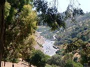
The suburb is at a high elevation in the Mount Lofty Ranges, and provides views over Adelaide as well as containing a renowned golf course and country club. Mining operations in the 19th century gave the area notoriety, but it has since developed slowly into a small, quiet and secluded suburb.
, Mount Osmond received the three allotments 1070, 1277 and 1278. While much of Adelaide was relatively quickly bought (but not necessarily settled) Mount Osmond did not enjoy any early buyers. The first reported activity in the area was after the mining rush of Glen Osmond
due to the Wheal Watkins
and Wheal Gawler mines. Lot 1277 yielded a mine in Slaughterhouse Gully but it was worked only briefly. Subsequent finds of bluestone
proved fruitful and the mineral was extracted until 1900, when mining ended and the last of the mines were either filled in or cordoned off.
Developers eventually bought the lot
s that composed Mount Osmond but once again interest in the suburb was minor. Attempts to bring in settlers culminated in the construction of Mount Osmond Road in 1882. It wound around the hills from where it began as an offshoot of Mount Barker Road
in the South. Developers broke down the three large lots into roughly two hundred 1 acres (4,046.9 m²) ones in the hope of sales. A few lots were sold to quarry
men and garden
ers around Mount Barker Road, but the vast remainder was leased to stockowners as pasture for their livestock. Much of Mount Osmond, along with a large portion of the surrounding area, was bought in 1907 by Ernest C. Sanders. His family made great use of the land, with his sons building houses on the vast property while raising sheep and growing hay. Considerable time was spent by the Sanders family in naming and mapping the area.
The Sanders family eventually decided to sell much of their portion of Mount Osmond, and around 1922–23 it was put on the market. Like earlier attempts at sales on Mount Osmond, little interest was received and none was sold until 1925. The land was developed into a golf course
and Country Club
with the assistance of the Burnside Council
and its engineers. Credit to the novel idea went to H.E.S. Melbourne, Burnside's chief engineer at the time – who found support among numerous Burnside Councillors. The golf course and country club were developed on the highest part of the mount, on 85 acres (34.4 ha) of former Sanders estate. The remaining land was sold by the country club to buyers with strict rules on the development and maintenance of the properties – specific rules applying to aesthetic features, particularly gardens, are of note. Even with a golf course and country club in the vicinity, as well as electricity and a water supply from Waterfall Gully's first creek the eighteen marketed lots once again sold poorly.
One of the last large land purchases was that of Ross Thiem in the 1940s. A club member, C.W. Lloyd, sold 200 acre (0.809372 km²) around the golf course, which was again used as pasture by Thiem, who ran sheep on the property – and was the last to do so. The Highways Department also acquired land in 1951, buying 200 acre (0.809372 km²) of land above Beaumont for future transport planning. Thiem's land was eventually sold in the 1950s, to the Rossdale Property Co. Their subsequent attempts at selling the land were just as fruitless as those before, and once again the property changed hands to the Mount Osmond Heights Pty Ltd. The land was newly subdivided
, and it was in the late 1960s that finally much of Mount Osmond was sold to residential buyers. Fifty-two out of the 116 new sites had been sold by 12 October 1968 at an average of $3,500, according to the Adelaide daily The Advertiser
. Since the land sales of that era, Mount Osmond has developed slowly because of the scarcity of land and the housing and development restrictions of the Hills Face Zone
. Now the suburb is home to large, extravagant, tree-filled houses and properties. With the upgrade of Mount Barker Road to the Adelaide-Crafers Highway
(leading to the South Eastern Freeway
) from 1997, Mount Osmond received its own freeway interchange as part of the development.
The Old Bullock/Long Ridge track runs along Long Ridge towards Eagle on the Hill. Much of the housing and residential properties are on the North-West side of the Mount, as to enable views over Adelaide. A few small settlements and paddocks with livestock (sheep, goats and deer) are still present on the slopes between the South Eastern Freeway and the Long Ridge Track.
While the suburb still contains a notable amount of native vegetation, and has not been exposed to invasive introduced species like other areas have, much of it was originally cleared for grazing and has yet to grow back to the same extent. Before European Settlement Grey Box, SA Blue Gum, Sheoak, Manna Gum and River Red Gum trees were native to and grew in the area, particularly on the slopes leading down to the Adelaide Plains
.
 Due to the suburb's relative isolation and hilly geography, it contains very few roads and does not conform to Adelaide's typical grid pattern – despite the suburb's age. The earliest road to be built was Mount Osmond Road, and done so by early developers in 1882 to make the suburb more attractive to prospective buyers. Mount Osmond Road remains one of two sealed roads which can today access Mount Osmond and is located to the South of the suburb. It begins as the first interchange on the South Eastern Freeway
(formerly Mount Barker Road) and then winds around the Mount to the top of the mount and around the golf course. The other sealed road that provides access to Mount Osmond is Hayward Drive, which starts in Beaumont
and then winds around the hills to meet the rest of the suburb's road network.
Numerous fire and walking tracks, among them the Old Bullock Track and the Pioneer Women's Heritage Trail, also access Mount Osmond from Waterfall Gully
, Eagle On The Hill
, Beaumont
and Glen Osmond. Public Transport is provided by the Adelaide Metro
, but no buses run through Mount Osmond itself. Stops can be found in neighbouring suburbs. The bikeway adjacent to the South Eastern Freeway winds past at the foot of Mount Osmond and can be accessed through the interchange.
Census of Population and Housing, the population of the Mount Osmond census area (which includes the suburbs of Glen Osmond
, Leawood Gardens
and Waterfall Gully
) was 2,497 people, in an area of 6.08 square kilometres. Females outnumbered males 54.2% to 45.8%, and some 21.4% of the population was born overseas (see chart for a breakdown). There was only a slight change in the 2006 census, with the population increasing by 25 to 2,522. Mount Osmond itself had a population of 612 during the 2006 census.
The eight strongest religious affiliations in the area (based on the 2006 census figures) were (in descending order): Anglican, Catholic, Uniting
, Lutheran
, Orthodox Christian
, Buddhist
, Presbyterian, Church of Christ
and Baptist
(a combination of other Christian faiths came in somewhere between Presbyterians and the Church of Christ, with 31 adherents). Also of note is the high occurrence of religious
affiliation (67.3%) in the region in comparison to the Adelaide (and national) average. Christian belief (64.4%) is most prominent, with little growth in other religions.
Residents in these four suburbs are more affluent than the Adelaide average, with a high occurrence of incomes over A$
1000 per week, which is also above the average for the City of Burnside. A majority of workers are employed in professional or white collar
fields.
The census area that incorporates Mount Osmond has a larger proportion of those in both the younger (0-17) and older (60+) age ranges than in the City of Burnside as a whole, and there have been no "numerically significant" changes in the age distribution between the 2001 and 2006 censuses. Similarly, family numbers are also stable, with almost no change between 2001 and 2006.
. While Wheal Gawler and Wheal Watkins
are former open-cut mines
(located in Glen Osmond), Mount Osmond contains more mineshaft
s which are up to sixty metres deep.
Mount Osmond Golf Course is located on the very top of the suburb, and includes its peak. Open only to members, the course's fairways and greens provide a spectacular backdrop of the Adelaide Plains, Mount Lofty Ranges and Golf St. The Old Toll House is located at the start of the Adelaide-Crafers Highway
. Vincent to members and visitors. The English-Manor style clubrooms also cater to functions and special events.
Walking trails are abundant. While a historical walk through the mines can be taken from Beaumont
or Glen Osmond, longer walks provide access to numerous attractions including Waterfall Gully
's falls, the Cleland Wildlife Park and the Adelaide Hills
town of Crafers. Walking the Long Ridge track, between the valley of the South Eastern Freeway
and Waterfall Gully provides spectacular views of Adelaide
. Mount Osmond also contains a small bed and breakfast
, located on Mount Osmond Road.
Mount Osmond is part of the state electoral district of Bragg, which has been held since 2002 by Liberal MP Vickie Chapman
. In federal politics, the suburb is part of the division of Sturt
, and has been represented by Christopher Pyne
since 1993. The results shown are from the closest polling station to Mount Osmond—which is located outside of the suburb—at St Saviour's Church Hall on Pridmore Road in Glen Osmond. Both electorates have traditionally gone to the Liberal Party
, and Bragg in particular is regarded as a very safe Liberal seat. However, in the 2007 federal election, a strong swing towards the Labor Party
and their candidate, Mia Handshin
, resulted in the electorate transforming from a "safe [federal] Liberal seat into a marginal one".
In local government
, Mount Osmond is part of the ward of Beaumont within the City of Burnside, and the current Mayor for the district is Wendy Greiner. Beaumont is currently represented by councilors Andrew Hillier and Davina Quirke.
South Australia
South Australia is a state of Australia in the southern central part of the country. It covers some of the most arid parts of the continent; with a total land area of , it is the fourth largest of Australia's six states and two territories.South Australia shares borders with all of the mainland...
n capital city of Adelaide
Adelaide
Adelaide is the capital city of South Australia and the fifth-largest city in Australia. Adelaide has an estimated population of more than 1.2 million...
. It is part of the City of Burnside
City of Burnside
The City of Burnside is a local government area with an estimated population of 44,300 people in the South Australian city of Adelaide. Burnside was founded in August 1856 as the District Council of Burnside, and was classed as a city in 1943. It is named after the property of an early settler and...
Local Government Area and located in the foothills of the Adelaide Hills
Adelaide Hills
The Adelaide Hills are part of the Mount Lofty Ranges, east of the city of Adelaide in the state of South Australia. It is unofficially centred on the largest town in the area, Mount Barker, which has a population of around 29,000 and is also one of Australia's fastest growing towns.- History :The...
, five kilometres south east of the city centre. The suburb is high on the hill of the same name, which is the last hill on the right when approaching Adelaide down the South Eastern Freeway
South Eastern Freeway
The South Eastern Freeway is a 66 kilometre four-lane divided carriageway road in South Australia linking the Adelaide-Crafers Highway to the Princes Highway at the Swanport Bridge, a one kilometre long bridge over the River Murray, near Murray Bridge...
before the road levels out onto the Adelaide Plains
Adelaide Plains
The Adelaide Plains is the area in South Australia between the Mount Lofty Ranges on the east and Gulf St Vincent on the west. The plains are generally fertile with annual rainfall of about per year....
. It is bounded to the north by the suburb of Beaumont
Beaumont, South Australia
Beaumont is a suburb of Adelaide in the City of Burnside. Founded as a purpose-built village by Sir Samuel Davenport in 1848, it initially struggled due to high land prices in the area. However, with Adelaide's inevitable expansion residents eventually settled...
, to the north-east by Burnside
Burnside, South Australia
Burnside is a small suburb that is part of the City of Burnside in the eastern suburbs of Adelaide. It is primarily a residential suburb, and was one of the first suburbs of Adelaide...
, to the east by Waterfall Gully, to the south by Leawood Gardens
Leawood Gardens, South Australia
Leawood Gardens is a small suburb of Adelaide, South Australia in both the City of Mitcham and the City of Burnside located in the foothills of the Adelaide Hills....
/Eagle On The Hill
Eagle on the Hill, South Australia
Eagle On The Hill is an unbounded locality of Adelaide in the Adelaide Foothills. It borders Mount Osmond and Waterfall Gully.The village is located on Mount Barker Road, which was the only connection from Adelaide to the South Eastern Freeway. Once the Adelaide-Crafers Highway through the Heysen...
, to the south-west by Urrbrae
Urrbrae, South Australia
Urrbrae is a suburb of Adelaide, South Australia. It is located in the City of Mitcham.Located at the foot of the Adelaide Hills, it is bordered on the east by the South Eastern Freeway, and the Old Toll House, which marked the traditional entrance to the city of Adelaide in the 19th...
, to the west by Glen Osmond
Glen Osmond, South Australia
Glen Osmond is a small suburb of Adelaide, South Australia in the City of Burnside located in the foothills of the Adelaide Hills.-References:...
and to the north-west by St Georges.
The suburb is at a high elevation in the Mount Lofty Ranges, and provides views over Adelaide as well as containing a renowned golf course and country club. Mining operations in the 19th century gave the area notoriety, but it has since developed slowly into a small, quiet and secluded suburb.
Aboriginal culture
Mount Osmond is within the traditional lands of the Kaurna people, and forms part of the Mount Lofty Ranges and is therefore part of the Dreamtime story of the ancestor-creator Nganno. According to the legend, Nganno was wounded in a battle and laid down to die, forming the Mount Lofty Ranges.European settlement
When Adelaide was first planned and mapped out by Col. William LightWilliam Light
Colonel William Light was a British military officer and the first Surveyor-General of the Colony of South Australia...
, Mount Osmond received the three allotments 1070, 1277 and 1278. While much of Adelaide was relatively quickly bought (but not necessarily settled) Mount Osmond did not enjoy any early buyers. The first reported activity in the area was after the mining rush of Glen Osmond
Glen Osmond, South Australia
Glen Osmond is a small suburb of Adelaide, South Australia in the City of Burnside located in the foothills of the Adelaide Hills.-References:...
due to the Wheal Watkins
Wheal Watkins
Wheal Watkins was previously a mine in the Adelaide, Australia suburb of Glen Osmond. It yielded silver and lead in the mid 19th century. The ore body was discovered in March 1841, and mining commenced soon after. Wheal Watkins opened in 1843 and operated until 1851, when the miners left for the...
and Wheal Gawler mines. Lot 1277 yielded a mine in Slaughterhouse Gully but it was worked only briefly. Subsequent finds of bluestone
Bluestone
Bluestone is a cultural or commercial name for a number of dimension or building stone varieties, including:*a feldspathic sandstone in the U.S. and Canada;*limestone in the Shenandoah Valley in the U.S...
proved fruitful and the mineral was extracted until 1900, when mining ended and the last of the mines were either filled in or cordoned off.
Developers eventually bought the lot
Real property
In English Common Law, real property, real estate, realty, or immovable property is any subset of land that has been legally defined and the improvements to it made by human efforts: any buildings, machinery, wells, dams, ponds, mines, canals, roads, various property rights, and so forth...
s that composed Mount Osmond but once again interest in the suburb was minor. Attempts to bring in settlers culminated in the construction of Mount Osmond Road in 1882. It wound around the hills from where it began as an offshoot of Mount Barker Road
Adelaide-Crafers Highway
The Adelaide-Crafers Highway is a 10 kilometre controlled-access highway linking Adelaide city centre to Crafers in the Adelaide hills, and continuing from Crafers as the South Eastern Freeway. The highway is ten kilometres long, including 500 metre long twin-tube tunnels , the first of their kind...
in the South. Developers broke down the three large lots into roughly two hundred 1 acres (4,046.9 m²) ones in the hope of sales. A few lots were sold to quarry
Quarry
A quarry is a type of open-pit mine from which rock or minerals are extracted. Quarries are generally used for extracting building materials, such as dimension stone, construction aggregate, riprap, sand, and gravel. They are often collocated with concrete and asphalt plants due to the requirement...
men and garden
Garden
A garden is a planned space, usually outdoors, set aside for the display, cultivation, and enjoyment of plants and other forms of nature. The garden can incorporate both natural and man-made materials. The most common form today is known as a residential garden, but the term garden has...
ers around Mount Barker Road, but the vast remainder was leased to stockowners as pasture for their livestock. Much of Mount Osmond, along with a large portion of the surrounding area, was bought in 1907 by Ernest C. Sanders. His family made great use of the land, with his sons building houses on the vast property while raising sheep and growing hay. Considerable time was spent by the Sanders family in naming and mapping the area.
The Sanders family eventually decided to sell much of their portion of Mount Osmond, and around 1922–23 it was put on the market. Like earlier attempts at sales on Mount Osmond, little interest was received and none was sold until 1925. The land was developed into a golf course
Golf course
A golf course comprises a series of holes, each consisting of a teeing ground, fairway, rough and other hazards, and a green with a flagstick and cup, all designed for the game of golf. A standard round of golf consists of playing 18 holes, thus most golf courses have this number of holes...
and Country Club
Country club
A country club is a private club, often with a closed membership, that typically offers a variety of recreational sports facilities and is located in city outskirts or rural areas. Activities may include, for example, any of golf, tennis, swimming or polo...
with the assistance of the Burnside Council
City of Burnside
The City of Burnside is a local government area with an estimated population of 44,300 people in the South Australian city of Adelaide. Burnside was founded in August 1856 as the District Council of Burnside, and was classed as a city in 1943. It is named after the property of an early settler and...
and its engineers. Credit to the novel idea went to H.E.S. Melbourne, Burnside's chief engineer at the time – who found support among numerous Burnside Councillors. The golf course and country club were developed on the highest part of the mount, on 85 acres (34.4 ha) of former Sanders estate. The remaining land was sold by the country club to buyers with strict rules on the development and maintenance of the properties – specific rules applying to aesthetic features, particularly gardens, are of note. Even with a golf course and country club in the vicinity, as well as electricity and a water supply from Waterfall Gully's first creek the eighteen marketed lots once again sold poorly.
One of the last large land purchases was that of Ross Thiem in the 1940s. A club member, C.W. Lloyd, sold 200 acre (0.809372 km²) around the golf course, which was again used as pasture by Thiem, who ran sheep on the property – and was the last to do so. The Highways Department also acquired land in 1951, buying 200 acre (0.809372 km²) of land above Beaumont for future transport planning. Thiem's land was eventually sold in the 1950s, to the Rossdale Property Co. Their subsequent attempts at selling the land were just as fruitless as those before, and once again the property changed hands to the Mount Osmond Heights Pty Ltd. The land was newly subdivided
Subdivision (land)
Subdivision is the act of dividing land into pieces that are easier to sell or otherwise develop, usually via a plat. The former single piece as a whole is then known in the United States as a subdivision...
, and it was in the late 1960s that finally much of Mount Osmond was sold to residential buyers. Fifty-two out of the 116 new sites had been sold by 12 October 1968 at an average of $3,500, according to the Adelaide daily The Advertiser
The Advertiser (Australia)
The Advertiser is a daily tabloid-format newspaper published in the city of Adelaide, South Australia. First published as a broadsheet named "The South Australian Advertiser" on 12 July 1858, it is currently printed daily from Monday to Saturday. A Sunday edition exists under the name of the Sunday...
. Since the land sales of that era, Mount Osmond has developed slowly because of the scarcity of land and the housing and development restrictions of the Hills Face Zone
Hills Face Zone
The Hills Face Zone is a large planning zone in Adelaide, South Australia. It restricts development in the Adelaide Foothills and Mount Lofty Ranges and extends from Gawler in the north to Sellicks Beach in the South. First suggested by the Liberal Playford Government in 1962, legislation was...
. Now the suburb is home to large, extravagant, tree-filled houses and properties. With the upgrade of Mount Barker Road to the Adelaide-Crafers Highway
Adelaide-Crafers Highway
The Adelaide-Crafers Highway is a 10 kilometre controlled-access highway linking Adelaide city centre to Crafers in the Adelaide hills, and continuing from Crafers as the South Eastern Freeway. The highway is ten kilometres long, including 500 metre long twin-tube tunnels , the first of their kind...
(leading to the South Eastern Freeway
South Eastern Freeway
The South Eastern Freeway is a 66 kilometre four-lane divided carriageway road in South Australia linking the Adelaide-Crafers Highway to the Princes Highway at the Swanport Bridge, a one kilometre long bridge over the River Murray, near Murray Bridge...
) from 1997, Mount Osmond received its own freeway interchange as part of the development.
Geography
Mount Osmond is composed of the Mount itself and a ridge (Long Ridge) stretching out to the south-east between the valley of the South Eastern Freeway and that of Waterfall Gully. Much of the suburb is more than 300 metres above sea level, with the Mount Osmond peak itself (located in the Golf Course grounds near the club house) at 384 metres. Between the North-East and North-West are slopes leading down to the suburbs of Beaumont, Glen Osmond and Waterfall Gully, most of which is owned as public land by various government departments – either as parks, tracks or vacant land for possible future use. A somewhat "ring" of reserves exist on the slopes anti-clockwise from the Old Bullock Track to Mount Osmond Road near the freeway interchange. The National Parks and Wildlife Service is responsible for maintaining the Mount Osmond Reserve, which is accessible via Dashwood Gully Reserve and Waterfall Gully Road.The Old Bullock/Long Ridge track runs along Long Ridge towards Eagle on the Hill. Much of the housing and residential properties are on the North-West side of the Mount, as to enable views over Adelaide. A few small settlements and paddocks with livestock (sheep, goats and deer) are still present on the slopes between the South Eastern Freeway and the Long Ridge Track.
While the suburb still contains a notable amount of native vegetation, and has not been exposed to invasive introduced species like other areas have, much of it was originally cleared for grazing and has yet to grow back to the same extent. Before European Settlement Grey Box, SA Blue Gum, Sheoak, Manna Gum and River Red Gum trees were native to and grew in the area, particularly on the slopes leading down to the Adelaide Plains
Adelaide Plains
The Adelaide Plains is the area in South Australia between the Mount Lofty Ranges on the east and Gulf St Vincent on the west. The plains are generally fertile with annual rainfall of about per year....
.
Transport
South Eastern Freeway
The South Eastern Freeway is a 66 kilometre four-lane divided carriageway road in South Australia linking the Adelaide-Crafers Highway to the Princes Highway at the Swanport Bridge, a one kilometre long bridge over the River Murray, near Murray Bridge...
(formerly Mount Barker Road) and then winds around the Mount to the top of the mount and around the golf course. The other sealed road that provides access to Mount Osmond is Hayward Drive, which starts in Beaumont
Beaumont, South Australia
Beaumont is a suburb of Adelaide in the City of Burnside. Founded as a purpose-built village by Sir Samuel Davenport in 1848, it initially struggled due to high land prices in the area. However, with Adelaide's inevitable expansion residents eventually settled...
and then winds around the hills to meet the rest of the suburb's road network.
Numerous fire and walking tracks, among them the Old Bullock Track and the Pioneer Women's Heritage Trail, also access Mount Osmond from Waterfall Gully
Waterfall Gully, South Australia
Waterfall Gully is an outer suburb of the South Australian capital city of Adelaide. It is located in the foothills of the Mount Lofty Ranges around east-south-east of Adelaide's central business district . For the most part, the suburb encompasses one long gully with First Creek at its centre and...
, Eagle On The Hill
Eagle on the Hill, South Australia
Eagle On The Hill is an unbounded locality of Adelaide in the Adelaide Foothills. It borders Mount Osmond and Waterfall Gully.The village is located on Mount Barker Road, which was the only connection from Adelaide to the South Eastern Freeway. Once the Adelaide-Crafers Highway through the Heysen...
, Beaumont
Beaumont, South Australia
Beaumont is a suburb of Adelaide in the City of Burnside. Founded as a purpose-built village by Sir Samuel Davenport in 1848, it initially struggled due to high land prices in the area. However, with Adelaide's inevitable expansion residents eventually settled...
and Glen Osmond. Public Transport is provided by the Adelaide Metro
Adelaide Metro
Adelaide Metro is the public transport system of the South Australian capital of Adelaide and the brand name of the Public Transport Division of the Department of Planning, Transport and Infrastructure. It is an intermodal system with services provided by bus, tram or commuter rail throughout the...
, but no buses run through Mount Osmond itself. Stops can be found in neighbouring suburbs. The bikeway adjacent to the South Eastern Freeway winds past at the foot of Mount Osmond and can be accessed through the interchange.
Residents
In the 2001 Australian Bureau of StatisticsAustralian Bureau of Statistics
The Australian Bureau of Statistics is Australia's national statistical agency. It was created as the Commonwealth Bureau of Census and Statistics on 8 December 1905, when the Census and Statistics Act 1905 was given Royal assent. It had its beginnings in section 51 of the Constitution of Australia...
Census of Population and Housing, the population of the Mount Osmond census area (which includes the suburbs of Glen Osmond
Glen Osmond, South Australia
Glen Osmond is a small suburb of Adelaide, South Australia in the City of Burnside located in the foothills of the Adelaide Hills.-References:...
, Leawood Gardens
Leawood Gardens, South Australia
Leawood Gardens is a small suburb of Adelaide, South Australia in both the City of Mitcham and the City of Burnside located in the foothills of the Adelaide Hills....
and Waterfall Gully
Waterfall Gully, South Australia
Waterfall Gully is an outer suburb of the South Australian capital city of Adelaide. It is located in the foothills of the Mount Lofty Ranges around east-south-east of Adelaide's central business district . For the most part, the suburb encompasses one long gully with First Creek at its centre and...
) was 2,497 people, in an area of 6.08 square kilometres. Females outnumbered males 54.2% to 45.8%, and some 21.4% of the population was born overseas (see chart for a breakdown). There was only a slight change in the 2006 census, with the population increasing by 25 to 2,522. Mount Osmond itself had a population of 612 during the 2006 census.
The eight strongest religious affiliations in the area (based on the 2006 census figures) were (in descending order): Anglican, Catholic, Uniting
Uniting Church in Australia
The Uniting Church in Australia was formed on 22 June 1977 when many congregations of the Methodist Church of Australasia, the Presbyterian Church of Australia and the Congregational Union of Australia came together under the Basis of Union....
, Lutheran
Lutheranism
Lutheranism is a major branch of Western Christianity that identifies with the theology of Martin Luther, a German reformer. Luther's efforts to reform the theology and practice of the church launched the Protestant Reformation...
, Orthodox Christian
Eastern Orthodox Church
The Orthodox Church, officially called the Orthodox Catholic Church and commonly referred to as the Eastern Orthodox Church, is the second largest Christian denomination in the world, with an estimated 300 million adherents mainly in the countries of Belarus, Bulgaria, Cyprus, Georgia, Greece,...
, Buddhist
Buddhism
Buddhism is a religion and philosophy encompassing a variety of traditions, beliefs and practices, largely based on teachings attributed to Siddhartha Gautama, commonly known as the Buddha . The Buddha lived and taught in the northeastern Indian subcontinent some time between the 6th and 4th...
, Presbyterian, Church of Christ
Church of Christ
Churches of Christ are autonomous Christian congregations associated with one another through common beliefs and practices. They seek to base doctrine and practice on the Bible alone, and seek to be New Testament congregations as originally established by the authority of Christ. Historically,...
and Baptist
Baptist
Baptists comprise a group of Christian denominations and churches that subscribe to a doctrine that baptism should be performed only for professing believers , and that it must be done by immersion...
(a combination of other Christian faiths came in somewhere between Presbyterians and the Church of Christ, with 31 adherents). Also of note is the high occurrence of religious
Religion
Religion is a collection of cultural systems, belief systems, and worldviews that establishes symbols that relate humanity to spirituality and, sometimes, to moral values. Many religions have narratives, symbols, traditions and sacred histories that are intended to give meaning to life or to...
affiliation (67.3%) in the region in comparison to the Adelaide (and national) average. Christian belief (64.4%) is most prominent, with little growth in other religions.
Residents in these four suburbs are more affluent than the Adelaide average, with a high occurrence of incomes over A$
Australian dollar
The Australian dollar is the currency of the Commonwealth of Australia, including Christmas Island, Cocos Islands, and Norfolk Island, as well as the independent Pacific Island states of Kiribati, Nauru and Tuvalu...
1000 per week, which is also above the average for the City of Burnside. A majority of workers are employed in professional or white collar
White-collar worker
The term white-collar worker refers to a person who performs professional, managerial, or administrative work, in contrast with a blue-collar worker, whose job requires manual labor...
fields.
The census area that incorporates Mount Osmond has a larger proportion of those in both the younger (0-17) and older (60+) age ranges than in the City of Burnside as a whole, and there have been no "numerically significant" changes in the age distribution between the 2001 and 2006 censuses. Similarly, family numbers are also stable, with almost no change between 2001 and 2006.
Attractions
Mount Osmond contains a number of historical attractions; notably in the former mines and mining infrastructure that remains on the hillside as a reminder of its past. The mines continue up throughout the hills from Glen OsmondGlen Osmond, South Australia
Glen Osmond is a small suburb of Adelaide, South Australia in the City of Burnside located in the foothills of the Adelaide Hills.-References:...
. While Wheal Gawler and Wheal Watkins
Wheal Watkins
Wheal Watkins was previously a mine in the Adelaide, Australia suburb of Glen Osmond. It yielded silver and lead in the mid 19th century. The ore body was discovered in March 1841, and mining commenced soon after. Wheal Watkins opened in 1843 and operated until 1851, when the miners left for the...
are former open-cut mines
Open-pit mining
Open-pit mining or opencast mining refers to a method of extracting rock or minerals from the earth by their removal from an open pit or borrow....
(located in Glen Osmond), Mount Osmond contains more mineshaft
Shaft mining
Shaft mining or shaft sinking refers to the method of excavating a vertical or near-vertical tunnel from the top down, where there is initially no access to the bottom....
s which are up to sixty metres deep.
Mount Osmond Golf Course is located on the very top of the suburb, and includes its peak. Open only to members, the course's fairways and greens provide a spectacular backdrop of the Adelaide Plains, Mount Lofty Ranges and Golf St. The Old Toll House is located at the start of the Adelaide-Crafers Highway
Adelaide-Crafers Highway
The Adelaide-Crafers Highway is a 10 kilometre controlled-access highway linking Adelaide city centre to Crafers in the Adelaide hills, and continuing from Crafers as the South Eastern Freeway. The highway is ten kilometres long, including 500 metre long twin-tube tunnels , the first of their kind...
. Vincent to members and visitors. The English-Manor style clubrooms also cater to functions and special events.
Walking trails are abundant. While a historical walk through the mines can be taken from Beaumont
Beaumont, South Australia
Beaumont is a suburb of Adelaide in the City of Burnside. Founded as a purpose-built village by Sir Samuel Davenport in 1848, it initially struggled due to high land prices in the area. However, with Adelaide's inevitable expansion residents eventually settled...
or Glen Osmond, longer walks provide access to numerous attractions including Waterfall Gully
Waterfall Gully, South Australia
Waterfall Gully is an outer suburb of the South Australian capital city of Adelaide. It is located in the foothills of the Mount Lofty Ranges around east-south-east of Adelaide's central business district . For the most part, the suburb encompasses one long gully with First Creek at its centre and...
's falls, the Cleland Wildlife Park and the Adelaide Hills
Adelaide Hills
The Adelaide Hills are part of the Mount Lofty Ranges, east of the city of Adelaide in the state of South Australia. It is unofficially centred on the largest town in the area, Mount Barker, which has a population of around 29,000 and is also one of Australia's fastest growing towns.- History :The...
town of Crafers. Walking the Long Ridge track, between the valley of the South Eastern Freeway
South Eastern Freeway
The South Eastern Freeway is a 66 kilometre four-lane divided carriageway road in South Australia linking the Adelaide-Crafers Highway to the Princes Highway at the Swanport Bridge, a one kilometre long bridge over the River Murray, near Murray Bridge...
and Waterfall Gully provides spectacular views of Adelaide
Adelaide
Adelaide is the capital city of South Australia and the fifth-largest city in Australia. Adelaide has an estimated population of more than 1.2 million...
. Mount Osmond also contains a small bed and breakfast
Bed and breakfast
A bed and breakfast is a small lodging establishment that offers overnight accommodation and breakfast, but usually does not offer other meals. Since the 1980s, the meaning of the term has also extended to include accommodations that are also known as "self-catering" establishments...
, located on Mount Osmond Road.
Politics
|
| ||||||||||||||||||||||||||||||||||||
Mount Osmond is part of the state electoral district of Bragg, which has been held since 2002 by Liberal MP Vickie Chapman
Vickie Chapman
Vickie Ann Chapman is an Australian politician, representing the South Australian House of Assembly seat of Bragg for the Liberal Party since 2002. She was Deputy Leader of the South Australian Opposition from 30 March 2006 until 4 July 2009.-Early life:Chapman was born in Kangaroo Island...
. In federal politics, the suburb is part of the division of Sturt
Division of Sturt
The Division of Sturt is an Australian Electoral Division in South Australia.First proclaimed for the 1949 election, Sturt was named for Captain Charles Sturt, nineteenth century explorer and the first European to discover the Murray River...
, and has been represented by Christopher Pyne
Christopher Pyne
Christopher Maurice Pyne, MP , Australian politician, has been a Liberal member of the Australian House of Representatives since 13 March 1993, representing the Division of Sturt, South Australia.-Early years:...
since 1993. The results shown are from the closest polling station to Mount Osmond—which is located outside of the suburb—at St Saviour's Church Hall on Pridmore Road in Glen Osmond. Both electorates have traditionally gone to the Liberal Party
Liberal Party of Australia
The Liberal Party of Australia is an Australian political party.Founded a year after the 1943 federal election to replace the United Australia Party, the centre-right Liberal Party typically competes with the centre-left Australian Labor Party for political office...
, and Bragg in particular is regarded as a very safe Liberal seat. However, in the 2007 federal election, a strong swing towards the Labor Party
Australian Labor Party
The Australian Labor Party is an Australian political party. It has been the governing party of the Commonwealth of Australia since the 2007 federal election. Julia Gillard is the party's federal parliamentary leader and Prime Minister of Australia...
and their candidate, Mia Handshin
Mia Handshin
Mia Handshin is an Adelaide-based political activist and a former columnist for The Advertiser newspaper in South Australia, contributing a weekly column to the opinion section from 1997 to 2007. She is an associate director of the consulting firm Government Relations Australia, and an adviser in...
, resulted in the electorate transforming from a "safe [federal] Liberal seat into a marginal one".
In local government
Local government
Local government refers collectively to administrative authorities over areas that are smaller than a state.The term is used to contrast with offices at nation-state level, which are referred to as the central government, national government, or federal government...
, Mount Osmond is part of the ward of Beaumont within the City of Burnside, and the current Mayor for the district is Wendy Greiner. Beaumont is currently represented by councilors Andrew Hillier and Davina Quirke.