
Uinta National Forest
Encyclopedia
United States National Forest
National Forest is a classification of federal lands in the United States.National Forests are largely forest and woodland areas owned by the federal government and managed by the United States Forest Service, part of the United States Department of Agriculture. Land management of these areas...
located in north central Utah
Utah
Utah is a state in the Western United States. It was the 45th state to join the Union, on January 4, 1896. Approximately 80% of Utah's 2,763,885 people live along the Wasatch Front, centering on Salt Lake City. This leaves vast expanses of the state nearly uninhabited, making the population the...
, USA. It was originally part of the Uinta Forest Reserve, created by Grover Cleveland
Grover Cleveland
Stephen Grover Cleveland was the 22nd and 24th president of the United States. Cleveland is the only president to serve two non-consecutive terms and therefore is the only individual to be counted twice in the numbering of the presidents...
on February 2, 1897. The name is derived from the Ute
Ute Tribe
The Ute are an American Indian people now living primarily in Utah and Colorado. There are three Ute tribal reservations: Uintah-Ouray in northeastern Utah ; Southern Ute in Colorado ; and Ute Mountain which primarily lies in Colorado, but extends to Utah and New Mexico . The name of the state of...
word Yoov-we-teuh which means pine forest. Because of changes to the boundaries over the years, the Uinta Mountains
Uinta Mountains
The Uinta Mountains are a high chain of mountains in northeastern Utah and extreme northwestern Colorado in the United States. A subrange of the Rocky Mountains, they are unusual for being the highest range in the contiguous United States running east to west, and lie approximately east of Salt...
are now located in the Wasatch-Cache National Forest
Wasatch-Cache National Forest
Uinta-Wasatch-Cache National Forest is a United States National Forest located primarily in northern Utah , with smaller parts extending into southeastern Idaho and southwestern Wyoming . The name is from the Ute word Wasatch for a low place in high mountains, and the French word Cache meaning to...
. In August 2007 it was announced that the Uinta National Forest would merge with the Wasatch-Cache National Forest based in Salt Lake City, Utah
Salt Lake City, Utah
Salt Lake City is the capital and the most populous city of the U.S. state of Utah. The name of the city is often shortened to Salt Lake or SLC. With a population of 186,440 as of the 2010 Census, the city lies in the Salt Lake City metropolitan area, which has a total population of 1,124,197...
, 50 miles (80.5 km) north of Provo, Utah.
The Uinta National Forest was headquartered in Provo, Utah
Provo, Utah
Provo is the third largest city in the U.S. state of Utah, located about south of Salt Lake City along the Wasatch Front. Provo is the county seat of Utah County and lies between the cities of Orem to the north and Springville to the south...
with four outlying district offices located in Pleasant Grove
Pleasant Grove, Utah
Pleasant Grove, also known as "Utah's City of Trees", is a city in Utah County, Utah, United States. It is part of the Provo–Orem, Utah Metropolitan Statistical Area. The population was 33,798 at the 2008 census estimates.-History:...
, Heber
Heber, Utah
Heber City is a city in Wasatch County, Utah, United States. The population was 7,297 at the 2000 census. Heber City was founded by English emigrants who were members of The Church of Jesus Christ of Latter-day Saints in the late 1850s, and is named after the Mormon apostle Heber C. Kimball. It is...
, Spanish Fork
Spanish Fork, Utah
Spanish Fork is a city in Utah County, Utah, United States. It is part of the Provo–Orem, Utah Metropolitan Statistical Area. The population was 31,497 as of the 2008 census estimate.-History:Spanish Fork was settled by LDS pioneers in 1851...
, and Nephi, Utah
Nephi, Utah
Nephi is a city in Juab County, Utah, United States. It is part of the Provo–Orem, Utah Metropolitan Statistical Area. The population was 4,733 at the 2000 census. It is the county seat of Juab County. It was settled by Mormon pioneers in 1851, and is the principal city in Juab Valley, an...
until August 2007. The Uinta National Forest is now managed as one unit along with the Wasatch-Cache National Forest
Wasatch-Cache National Forest
Uinta-Wasatch-Cache National Forest is a United States National Forest located primarily in northern Utah , with smaller parts extending into southeastern Idaho and southwestern Wyoming . The name is from the Ute word Wasatch for a low place in high mountains, and the French word Cache meaning to...
as the Uinta-Wasatch-Cache National Forest. Managing 880719 acre, the Uinta National Forest is less than 45 minutes south of Salt Lake City and only minutes away from Provo, Utah. In descending order of land area it is located in parts of Utah
Utah County, Utah
Utah County is a county located in the U.S. state of Utah. As of 2000, the population was 368,536 and by 2008 was estimated at 530,837. It was named for the Spanish name for the Ute Indians. The county seat and largest city is Provo...
, Wasatch
Wasatch County, Utah
Wasatch County is a county located in the U.S. state of Utah. It was named for a Ute Indian word meaning mountain pass or low place in the high mountains. Its county seat and largest city is Heber City.The county is governed by a county council with an appointed county manager.Wasatch County is...
, Juab
Juab County, Utah
Juab County is a county located in the U.S. state of Utah. As of 2000 the population was 8,238, and by 2005 had been estimated at 9,113. It was named from an Indian word meaning thirsty valley, or possibly only valley. Its county seat and largest city is Nephi.Juab County is part of the...
, and Sanpete
Sanpete County, Utah
Sanpete County is a county located in the U.S. state of Utah. The population according to the 2010 U.S. Census was 27,822. It was possibly named for a Ute Indian chief named Sanpitch, which was corrupted to Sanpete. Its county seat is Manti and its largest city is Ephraim.-Geography:According to...
counties.
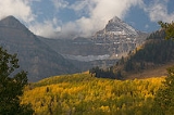
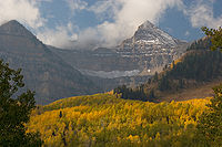
One of the most prominent features of the Uinta National Forest is the Mount Timpanogos
Mount Timpanogos
Mount Timpanogos, sometimes informally referred to as Timp, is the second highest mountain in Utah's Wasatch Range. Timpanogos rises to an elevation of 11,749 feet above sea level in the Uinta National Forest...
mountain peak, towering over 11750 feet (3,581.4 m) above sea level. However, the highest point in the Unita National Forest (as well as the entire Wasatch Range
Wasatch Range
The Wasatch Range is a mountain range that stretches approximately from the Utah-Idaho border, south through central Utah in the western United States. It is generally considered the western edge of the greater Rocky Mountains, and the eastern edge of the Great Basin region...
) is the nearby, but less prominent, Mount Nebo
Mount Nebo (Utah)
Mount Nebo is the southernmost and highest mountain in the Wasatch Range of Utah, in the United States. Named after the biblical Mount Nebo overlooking Israel, which is said to be the place of Moses' death, it is the centerpiece of the Mount Nebo Wilderness, inside the Uinta National Forest.Mount...
at 11928 feet (3,635.7 m) above sea level.