

Walworth, County Durham
Encyclopedia
Walworth is a central small village with outlying farmsteads, which together constitute a scattered village in the borough of Darlington
and the ceremonial county
of County Durham
, England
. It is a civil parish which does not have a church. It is situated 2.5 miles (4 km) to the north west of Darlington
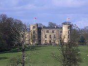
. The nucleus of the central village is the 16th century Walworth Castle
, which is now an hotel. On the north side of the village, around North Farm, are earthworks
signifying a lost settlement
, grouped around a barn which was once a chapel.
 Walworth and Walworth Gate are said to be on the line of the Roman road
, Dere Street
. Walworth is located at the T-junction where Newton Lane meets Walworth Road and the disused Quarry Hole, 2.5 miles (4 km) north-west of Darlington
and 0.31 mile (0.4988954 km) east of Denton
The village is triangular in plan, with Walworth Castle
and Walworth Park at its centre. North Farm and the lost settlement
of Walworth are at the north corner; Castle farm and Tomtit Wood are at the south-west corner, and Walworth Grange and a few houses are at the south-east corner. The village used to be part of Heighington
parish, but the settlement now has its own civil parish
. Although there is evidence of a former chapel in the lost settlement, the village does not have a church. The population here is very low; in 2001 there were only 167 people on the electoral roll of Denton
, Walworth and Houghton-le-Side
who were eligible to vote at Walworth Castle polling station.
in around 1600 for Thomas Jennison. It may be that earthworks
and cropmark
s in Walworth Park in the castle grounds signify a lost settlement associated with the one at North Farm.
claimed it. It is thought that Walworth was planned as a village with the previous castle around 1150 by the Hansard family as part of their 1100 acres (4.5 km²) estate. There is a legend that Malcolm III of Scotland
destroyed the village on his way along the River Tees
. Following the Black Death
there was a change of ownership of the manor to the Neville family
by 1367, but in 1391 Robert Hansard claimed it back. The Ayscough
family acquired the manor by marriage in 1539, then Thomas Jenison bought it in 1579 when the Ayscough family had no heirs. At the death of Elizabeth Jenison in 1605, the farm stock inventory included 50 ox
en besides cattle, sheep, pigs, horses and corn. In 1759 the estate left the hands of the Jenisons due to the death and debts of Ralph Jenison. From 1759 to 1831 the estate belonged to Matthew Stephenson, and then it was sold to the Aylmer family who owned it until 1931. Their descendants Neville and Charles Eade owned it from 1931 to 1950, and then it was sold in 1950 to Durham County Council
. The estate was broken up and sold into private ownership in 1981, and present ownership of the village is unknown.
or Roman
activity in this area, but the area has not been fully excavated. In May 2004 a barbed and tanged
arrowhead was found at Quarry Cottage, where Newton Lane meets Walworth Road. Because this site was a quarry, the arrowhead may have been moved from its original site before it was found. In 1991 some archaeological evaluation trenches were dug next to the castle itself, in advance of hotel development; however no traces were found of archaeological material. About 0.6 mile (0.965604 km) to the east of Walworth, in a field just east of Back Lane, is the site of a former post-medieval brick
and tile
works. There was another brick and tile works 0.3 mile (0.482802 km) north-east of North Farm on Silver Hill, just west of Back Lane.
North of the village, just south of New Moor Farm and just to the west of Walworth Road, is the site of a post-medieval lime kiln. The disused limestone
quarry
called Quarry Hole, where Newton Lane meets Walworth Road, is post-medieval also, and it once had an associated lime kiln. 0.9 miles (1.4 km) north-west of Walworth, between Newton Lane and the A68 road
, is the post-medieval Paradise Cottage, once known as Hood's Cottage, with an associated well
. There is an overgrown well on the west side of Walworth Road and level with the castle gate, at the north end of Tomtit Wood. It is made of stone with a trough to collect water. Estimated to be about 0.31 mile (0.4988954 km) west of Walworth village, and halfway between Walworth and Denton
, is the site of a medieval
mill. The evidence for this is from field
names on tithe maps
and manuscript
s. There is a late 18th or early 19th century listed ice house to the east of Quarry End, at Quarry Hole. It is built into a bank, and has a partially−collapsed barrel−vaulted
passage connected to a deep, egg−shaped cavity intended for the ice. It is built of coursed rubble and the inside is brick−lined. On the east side of Walworth Grange are a Grade II listed late 18th or early 19th century threshing
barn and gin gang
. They are built of limestone
with pantiled roofs, and the gin gang is semi-octagonal with square piers and later infilled walls.
Parkside Farmhouse at Castle Farm is a listed building, built in the early 19th century with squared limestone walls and purple slate roof. On its south side is a large 19th century, two−storey, pantiled, square−plan dovecote
which is listed separately along with some sheds including a possible bee bole
. The 19th century limestone gate piers with rounded tops and 5 feet (1.5 m) to 6.5 feet (2 m) high limestone garden wall of Parkside Farmhouse are listed also. The wall has flat coping and is L-shaped, surrounding two sides of the farmhouse. The wall may have contained flues to heat soft fruit. Also on the south side of the farm house is another set of early 19th century listed sheds and barn with assorted roofing: asbestos, pantiles and stone flags. The single-storey sheds contain blocked arches. There is also a listed 19th century haybarn and former potato shed on the south side of the farmhouse. The haybarn is built of squared limestone and sandstone with brick arches.
signifying a lost settlement
. There are some isolated ruins and two rows of building foundations, and ditches and banks which form enclosures
. The chapel was built in 1180 of squared and coursed rubble, and has since been incorporated into the northernmost farm building with blocked original openings and indications of the original door and window still visible, although it has 19th century doorways and a pantiled roof. Inside there is evidence of a pointed arch containing a piscina
with trefoil head, and a large aumbry
at the east end of the south wall. The opening at the east end on the north wall is also possibly an aumbry. There is evidence of ridge and furrow
fields remaining in Walworth Park
which may be associated with this settlement. In 2007 there was a watching brief
when an electricity supply trench was dug in the middle of the lost settlement site, just north-east of the farm buildings, but no archaeological evidence was found.
Darlington (borough)
Darlington is a local government district and borough in North East England. In 2008 it had a resident population of 100,500 It borders County Durham to the north and west, North Yorkshire to the south along the line of the River Tees, and Stockton-on-Tees to the east.-Council:Traditionally part of...
and the ceremonial county
Ceremonial counties of England
The ceremonial counties are areas of England to which are appointed a Lord Lieutenant, and are defined by the government as counties and areas for the purposes of the Lieutenancies Act 1997 with reference to the metropolitan and non-metropolitan counties of England and Lieutenancies Act 1997...
of County Durham
County Durham
County Durham is a ceremonial county and unitary district in north east England. The county town is Durham. The largest settlement in the ceremonial county is the town of Darlington...
, England
England
England is a country that is part of the United Kingdom. It shares land borders with Scotland to the north and Wales to the west; the Irish Sea is to the north west, the Celtic Sea to the south west, with the North Sea to the east and the English Channel to the south separating it from continental...
. It is a civil parish which does not have a church. It is situated 2.5 miles (4 km) to the north west of Darlington
Darlington
Darlington is a market town in the Borough of Darlington, part of the ceremonial county of County Durham, England. It lies on the small River Skerne, a tributary of the River Tees, not far from the main river. It is the main population centre in the borough, with a population of 97,838 as of 2001...
. The nucleus of the central village is the 16th century Walworth Castle
Walworth Castle
Walworth Castle is a 16th century mansion house, built in the style of a medieval castle and situated at Walworth, near Darlington, County Durham, England. It is a Grade 1 listed building. It was completed around 1600, probably by Thomas Holt for Thomas Jenison. It stands on the site of a former...
, which is now an hotel. On the north side of the village, around North Farm, are earthworks
Earthworks (archaeology)
In archaeology, earthwork is a general term to describe artificial changes in land level. Earthworks are often known colloquially as 'lumps and bumps'. Earthworks can themselves be archaeological features or they can show features beneath the surface...
signifying a lost settlement
Abandoned village
An abandoned village is a village that has, for some reason, been deserted. In many countries, and throughout history, thousands of villages were deserted for a variety of causes...
, grouped around a barn which was once a chapel.
Central village location and structure
Roman roads in Britain
Roman roads, together with Roman aqueducts and the vast standing Roman army , constituted the three most impressive features of the Roman Empire. In Britain, as in other provinces, the Romans constructed a comprehensive network of paved trunk roads Roman roads, together with Roman aqueducts and the...
, Dere Street
Dere Street
Dere Street or Deere Street, was a Roman road between Eboracum and Veluniate, in what is now Scotland. It still exists in the form of the route of many major roads, including the A1 and A68 just north of Corbridge.Its name corresponds with the post Roman Anglo-Saxon kingdom of Deira, through...
. Walworth is located at the T-junction where Newton Lane meets Walworth Road and the disused Quarry Hole, 2.5 miles (4 km) north-west of Darlington
Darlington
Darlington is a market town in the Borough of Darlington, part of the ceremonial county of County Durham, England. It lies on the small River Skerne, a tributary of the River Tees, not far from the main river. It is the main population centre in the borough, with a population of 97,838 as of 2001...
and 0.31 mile (0.4988954 km) east of Denton
Denton, County Durham
Denton is a village in the borough of Darlington and the ceremonial county ofCounty Durham, England. It is situated a short distance to the north-west of Darlington....
The village is triangular in plan, with Walworth Castle
Walworth Castle
Walworth Castle is a 16th century mansion house, built in the style of a medieval castle and situated at Walworth, near Darlington, County Durham, England. It is a Grade 1 listed building. It was completed around 1600, probably by Thomas Holt for Thomas Jenison. It stands on the site of a former...
and Walworth Park at its centre. North Farm and the lost settlement
Abandoned village
An abandoned village is a village that has, for some reason, been deserted. In many countries, and throughout history, thousands of villages were deserted for a variety of causes...
of Walworth are at the north corner; Castle farm and Tomtit Wood are at the south-west corner, and Walworth Grange and a few houses are at the south-east corner. The village used to be part of Heighington
Heighington, County Durham
Heighington is a village in the borough of Darlington and ceremonial county of County Durham, England. It is situated between Darlington and Shildon, near Newton Aycliffe. One of its most significant features is St Michael's Church that sits in the middle of an exceptionally fine and large village...
parish, but the settlement now has its own civil parish
Civil parish
In England, a civil parish is a territorial designation and, where they are found, the lowest tier of local government below districts and counties...
. Although there is evidence of a former chapel in the lost settlement, the village does not have a church. The population here is very low; in 2001 there were only 167 people on the electoral roll of Denton
Denton, County Durham
Denton is a village in the borough of Darlington and the ceremonial county ofCounty Durham, England. It is situated a short distance to the north-west of Darlington....
, Walworth and Houghton-le-Side
Houghton-le-Side
Houghton-le-Side is a small village in the borough of Darlington and the ceremonial county of County Durham, England. It is situated a few miles to the south west of Newton Aycliffe....
who were eligible to vote at Walworth Castle polling station.
Walworth Castle
The central feature of the village, and its landmark for miles, is its very large, 16th century mansion house built in the style of a medieval castle, which is now an hotel. It is a Grade 1 listed building, probably built by Thomas HoltThomas Holt (architect)
Thomas Holt , was a seventeenth century English architect who designed a number of buildings at the University of Oxford....
in around 1600 for Thomas Jennison. It may be that earthworks
Earthworks (archaeology)
In archaeology, earthwork is a general term to describe artificial changes in land level. Earthworks are often known colloquially as 'lumps and bumps'. Earthworks can themselves be archaeological features or they can show features beneath the surface...
and cropmark
Cropmark
Cropmarks or Crop marks are a means through which sub-surface archaeological, natural and recent features may be visible from the air or a vantage point on higher ground or a temporary platform...
s in Walworth Park in the castle grounds signify a lost settlement associated with the one at North Farm.
History
The name, Walworth, means Welsh settlement, and it used to be known as Waleberge after the SaxonsAnglo-Saxons
Anglo-Saxon is a term used by historians to designate the Germanic tribes who invaded and settled the south and east of Great Britain beginning in the early 5th century AD, and the period from their creation of the English nation to the Norman conquest. The Anglo-Saxon Era denotes the period of...
claimed it. It is thought that Walworth was planned as a village with the previous castle around 1150 by the Hansard family as part of their 1100 acres (4.5 km²) estate. There is a legend that Malcolm III of Scotland
Malcolm III of Scotland
Máel Coluim mac Donnchada , was King of Scots...
destroyed the village on his way along the River Tees
River Tees
The River Tees is in Northern England. It rises on the eastern slope of Cross Fell in the North Pennines, and flows eastwards for 85 miles to reach the North Sea between Hartlepool and Redcar.-Geography:...
. Following the Black Death
Black Death in England
The pandemic known to history as the Black Death entered England in 1348, and killed between a third and more than half of the nation's inhabitants. The Black Death was the first and most severe manifestation of the Second Pandemic, probably caused by the Yersinia pestis bacteria. Originating in...
there was a change of ownership of the manor to the Neville family
House of Neville
The House of Neville is a noble house of early medieval origin, which was a leading force in English politics in the later middle ages...
by 1367, but in 1391 Robert Hansard claimed it back. The Ayscough
Ainscough
Ainscough is an old Lancashire family name, also spelled Ayscough, Aiskew, Askew, and Ascough.-Origins:It is thought that the name is derived from the Norse words "ask skog". Although other sources suggest that Aiskew is a corruption of the words "Eiki Skogr" translating to Oak Wood...
family acquired the manor by marriage in 1539, then Thomas Jenison bought it in 1579 when the Ayscough family had no heirs. At the death of Elizabeth Jenison in 1605, the farm stock inventory included 50 ox
Ox
An ox , also known as a bullock in Australia, New Zealand and India, is a bovine trained as a draft animal. Oxen are commonly castrated adult male cattle; castration makes the animals more tractable...
en besides cattle, sheep, pigs, horses and corn. In 1759 the estate left the hands of the Jenisons due to the death and debts of Ralph Jenison. From 1759 to 1831 the estate belonged to Matthew Stephenson, and then it was sold to the Aylmer family who owned it until 1931. Their descendants Neville and Charles Eade owned it from 1931 to 1950, and then it was sold in 1950 to Durham County Council
County Durham
County Durham is a ceremonial county and unitary district in north east England. The county town is Durham. The largest settlement in the ceremonial county is the town of Darlington...
. The estate was broken up and sold into private ownership in 1981, and present ownership of the village is unknown.
Historical sites
There is no evidence of prehistoricPrehistory
Prehistory is the span of time before recorded history. Prehistory can refer to the period of human existence before the availability of those written records with which recorded history begins. More broadly, it refers to all the time preceding human existence and the invention of writing...
or Roman
Roman Britain
Roman Britain was the part of the island of Great Britain controlled by the Roman Empire from AD 43 until ca. AD 410.The Romans referred to the imperial province as Britannia, which eventually comprised all of the island of Great Britain south of the fluid frontier with Caledonia...
activity in this area, but the area has not been fully excavated. In May 2004 a barbed and tanged
Tang (weaponry)
A tang or shank is the back portion of a tool where it extends into stock material or is connected to a handle as on a knife, sword, spear, arrowhead, chisel, screwdriver, etc...
arrowhead was found at Quarry Cottage, where Newton Lane meets Walworth Road. Because this site was a quarry, the arrowhead may have been moved from its original site before it was found. In 1991 some archaeological evaluation trenches were dug next to the castle itself, in advance of hotel development; however no traces were found of archaeological material. About 0.6 mile (0.965604 km) to the east of Walworth, in a field just east of Back Lane, is the site of a former post-medieval brick
Brickworks
A brickworks also known as a brick factory, is a factory for the manufacturing of bricks, from clay or shale. Usually a brickworks is located on a clay bedrock often with a quarry for clay on site....
and tile
Tile
A tile is a manufactured piece of hard-wearing material such as ceramic, stone, metal, or even glass. Tiles are generally used for covering roofs, floors, walls, showers, or other objects such as tabletops...
works. There was another brick and tile works 0.3 mile (0.482802 km) north-east of North Farm on Silver Hill, just west of Back Lane.
North of the village, just south of New Moor Farm and just to the west of Walworth Road, is the site of a post-medieval lime kiln. The disused limestone
Limestone
Limestone is a sedimentary rock composed largely of the minerals calcite and aragonite, which are different crystal forms of calcium carbonate . Many limestones are composed from skeletal fragments of marine organisms such as coral or foraminifera....
quarry
Quarry
A quarry is a type of open-pit mine from which rock or minerals are extracted. Quarries are generally used for extracting building materials, such as dimension stone, construction aggregate, riprap, sand, and gravel. They are often collocated with concrete and asphalt plants due to the requirement...
called Quarry Hole, where Newton Lane meets Walworth Road, is post-medieval also, and it once had an associated lime kiln. 0.9 miles (1.4 km) north-west of Walworth, between Newton Lane and the A68 road
A68 road
The A68 is a major road in the United Kingdom, running from Darlington in England to the A720 in Scotland.From Darlington, the road runs north, bypassing Bishop Auckland, and running through West Auckland, Toft Hill and Tow Law, past Consett and Corbridge...
, is the post-medieval Paradise Cottage, once known as Hood's Cottage, with an associated well
Water well
A water well is an excavation or structure created in the ground by digging, driving, boring or drilling to access groundwater in underground aquifers. The well water is drawn by an electric submersible pump, a trash pump, a vertical turbine pump, a handpump or a mechanical pump...
. There is an overgrown well on the west side of Walworth Road and level with the castle gate, at the north end of Tomtit Wood. It is made of stone with a trough to collect water. Estimated to be about 0.31 mile (0.4988954 km) west of Walworth village, and halfway between Walworth and Denton
Denton, County Durham
Denton is a village in the borough of Darlington and the ceremonial county ofCounty Durham, England. It is situated a short distance to the north-west of Darlington....
, is the site of a medieval
Middle Ages
The Middle Ages is a periodization of European history from the 5th century to the 15th century. The Middle Ages follows the fall of the Western Roman Empire in 476 and precedes the Early Modern Era. It is the middle period of a three-period division of Western history: Classic, Medieval and Modern...
mill. The evidence for this is from field
Field (agriculture)
In agriculture, the word field refers generally to an area of land enclosed or otherwise and used for agricultural purposes such as:* Cultivating crops* Usage as a paddock or, generally, an enclosure of livestock...
names on tithe maps
Tithe maps
The term Tithe map is usually applied to a map of an English or Welsh parish or township, prepared following the Tithe Commutation Act 1836. This act allowed tithes to be paid in cash rather than goods. The map and its accompanying schedule gave the names of all owners and occupiers of land in the...
and manuscript
Manuscript
A manuscript or handwrite is written information that has been manually created by someone or some people, such as a hand-written letter, as opposed to being printed or reproduced some other way...
s. There is a late 18th or early 19th century listed ice house to the east of Quarry End, at Quarry Hole. It is built into a bank, and has a partially−collapsed barrel−vaulted
Vault (architecture)
A Vault is an architectural term for an arched form used to provide a space with a ceiling or roof. The parts of a vault exert lateral thrust that require a counter resistance. When vaults are built underground, the ground gives all the resistance required...
passage connected to a deep, egg−shaped cavity intended for the ice. It is built of coursed rubble and the inside is brick−lined. On the east side of Walworth Grange are a Grade II listed late 18th or early 19th century threshing
Threshing
Threshing is the process of loosening the edible part of cereal grain from the scaly, inedible chaff that surrounds it. It is the step in grain preparation after harvesting and before winnowing, which separates the loosened chaff from the grain...
barn and gin gang
Gin gang
A gin gang, wheelhouse, roundhouse or horse−engine house, is a structure built to enclose a horse mill, usually circular but sometimes square or octagonal, attached to a threshing barn. Most were built in England in the late 18th and early 19th centuries...
. They are built of limestone
Limestone
Limestone is a sedimentary rock composed largely of the minerals calcite and aragonite, which are different crystal forms of calcium carbonate . Many limestones are composed from skeletal fragments of marine organisms such as coral or foraminifera....
with pantiled roofs, and the gin gang is semi-octagonal with square piers and later infilled walls.
Parkside Farmhouse at Castle Farm is a listed building, built in the early 19th century with squared limestone walls and purple slate roof. On its south side is a large 19th century, two−storey, pantiled, square−plan dovecote
Dovecote
A dovecote or dovecot is a structure intended to house pigeons or doves. Dovecotes may be square or circular free-standing structures or built into the end of a house or barn. They generally contain pigeonholes for the birds to nest. Pigeons and doves were an important food source historically in...
which is listed separately along with some sheds including a possible bee bole
Bee bole
A bee bole is a cavity or alcove in a wall or a separate free-standing structure set against a wall . A skep is placed inside the bee bole...
. The 19th century limestone gate piers with rounded tops and 5 feet (1.5 m) to 6.5 feet (2 m) high limestone garden wall of Parkside Farmhouse are listed also. The wall has flat coping and is L-shaped, surrounding two sides of the farmhouse. The wall may have contained flues to heat soft fruit. Also on the south side of the farm house is another set of early 19th century listed sheds and barn with assorted roofing: asbestos, pantiles and stone flags. The single-storey sheds contain blocked arches. There is also a listed 19th century haybarn and former potato shed on the south side of the farmhouse. The haybarn is built of squared limestone and sandstone with brick arches.
Lost settlement
At the north end of the village, the fields on the east and west sides of the North Farm buildings contain earthworksEarthworks (archaeology)
In archaeology, earthwork is a general term to describe artificial changes in land level. Earthworks are often known colloquially as 'lumps and bumps'. Earthworks can themselves be archaeological features or they can show features beneath the surface...
signifying a lost settlement
Abandoned village
An abandoned village is a village that has, for some reason, been deserted. In many countries, and throughout history, thousands of villages were deserted for a variety of causes...
. There are some isolated ruins and two rows of building foundations, and ditches and banks which form enclosures
Enclosure (archaeology)
In archaeology, an enclosure is one of the most common types of archaeological site. It is any area of land separated from surrounding land by earthworks, walls or fencing. Such a simple feature is found all over the world and during almost all archaeological periods...
. The chapel was built in 1180 of squared and coursed rubble, and has since been incorporated into the northernmost farm building with blocked original openings and indications of the original door and window still visible, although it has 19th century doorways and a pantiled roof. Inside there is evidence of a pointed arch containing a piscina
Piscina
A piscina is a shallow basin placed near the altar of a church, used for washing the communion vessels. The sacrarium is the drain itself. Anglicans usually refer to the basin, calling it a piscina. Roman Catholics usually refer to the drain, and by extension, the basin, as the sacrarium...
with trefoil head, and a large aumbry
Aumbry
In the Middle Ages an aumbry was a cabinet in the wall of a Christian church or in the sacristy which was used to store chalices and other vessels, as well as for the reserved sacrament, the consecrated elements from the Eucharist. This latter use was infrequent in pre-Reformation churches,...
at the east end of the south wall. The opening at the east end on the north wall is also possibly an aumbry. There is evidence of ridge and furrow
Ridge and furrow
Ridge and furrow is an archaeological pattern of ridges and troughs created by a system of ploughing used in Europe during the Middle Ages. The earliest examples date to the immediate post-Roman period and the system was used until the 17th century in some areas. Ridge and furrow topography is...
fields remaining in Walworth Park
Walworth Castle
Walworth Castle is a 16th century mansion house, built in the style of a medieval castle and situated at Walworth, near Darlington, County Durham, England. It is a Grade 1 listed building. It was completed around 1600, probably by Thomas Holt for Thomas Jenison. It stands on the site of a former...
which may be associated with this settlement. In 2007 there was a watching brief
Watching brief
In British archaeology a Watching Brief is a method of preserving archaeological remains by record in the face of development threat. An archaeologist is employed by the developer to monitor the excavation of foundation and service trenches, landscaping and any other intrusive work...
when an electricity supply trench was dug in the middle of the lost settlement site, just north-east of the farm buildings, but no archaeological evidence was found.