

Walcott, Norfolk
Encyclopedia
Walcott is a small village and civil parish on the North Norfolk
coast in England
between Mundesley
and Happisburgh
.
The name derives from the Celtic word Walecote, which means village by the wood. The village is 19.1 miles (30.7 km) north east of Norwich
, 11.9 miles (19.2 km) south east of Cromer
and 137 miles (220.5 km) north east of London
. The village lies 5.6 miles (9 km) east of the town of North Walsham
.
The village is the only point where the B1159
(the coast road) actually runs along the edge of the sea. This makes it a popular stopping off point for day-tripper
s and storm watchers.
The parish was created in 2008, having formerly been part of Happisburgh parish.
The last ice sheet left Norfolk around 16,000 BC allowing pine trees to colonise the region.
Between 10,000 - 6000 BC the climate became warm and dry allowing alder, oak, elm & lime into the region.
The increasing temperature caused the sea level to rise and around 5000 BC the North Sea was first connected to the English Channel via a narrow strait. Eventually there were wide inter-tidal estuaries around Norfolk, which started to deposit marine clay over the original peat in the Broadland area.
Around 3000 BC the Norfolk coastline was roughly similar to today's outline, although the local cliffs continued to erode. Some of the eroded material goes to form the sand bar, a few kilometres offshore, that runs parallel with the coastline and is a danger to local shipping.
During the Bronze Age (2,500 - 800 BC) the climate slowly became cooler although the sea level continued to rise and around 750 BC the sea started to breach the spits across the estuaries further south. This resulted in Walcott becoming part of a large peninsula with numerous islands and waterways in the south and east. This peninsula would have made an ideal area for man to colonize with fresh water, fishing and reeds (for thatch) in the west, sea fishing in the east. The good farming land and its isolation would have offered some degree of defence.
From the Iron Age to the end of the Roman period (800 BC - 410 AD) the climate became wet and cold and locally the sea level probably reached about 1.0 m above today's average.
Around 500 AD (during the Anglo-Saxon period) spits of land further south started once again to exclude the sea from the local estuaries and the inlets forming the peninsular began to 'dry out'. These natural barriers have subsequently been maintained by man to protect the farmland behind.
The coastal erosion in the vicinity has been estimated at an approximate rate of 1.0 m per year and accounts for the loss of an approximate 2.0 km wide strip of land since the Roman invasion of AD 43 as a result of which several medieval villages (eg Waxham Parva, Markesthorpe) disappeared into the sea.
Note: Details of the past vegetation and climate of the region have been determined from borehole logs (and pollen analysis) such as that at Ranworth Broad
.
Little activity is noted in the vicinity during the Mesolithic
or Middle Stone Age
Era (10,000 - 5000 BC) with few artefacts recorded.
During the Neolithic
or New Stone Age Era (5000 - 2500 BC) the majority of the artefacts found in the vicinity are concentrated on higher ground.
The number of Bronze Age
(2500 - 800 BC) artefacts recorded in the vicinity increases significantly from the Neolithic Era and possibly suggests an increase in the population. There is no natural copper or tin ore in Norfolk so all raw materials must have been imported, probably by trading.
Fewer artefacts dating from the Iron Age
(800 BC - 43 AD), compared to Bronze Age, have been recorded in the vicinity. However, this could just reflect the fact that iron deteriorates faster than bronze. Certainly more Iron Age pottery has been recorded in the vicinity than Bronze Age pottery.
The Norfolk Iron Age tribe were called the Iceni
and probably consisted of a group of smaller tribes, as in 54 BC Julius Caesar describes then as the Cenimagni - the Greater Iceni. It is possible that east Norfolk (including Walcott) may have been occupied by one of these smaller (possibly poorer) tribes, which could explain the general lack of finds. Some historians consider that the west side of Norfolk was settled before the east side and that society underwent a progressive fragmentation during the Iron Age until around 60 BC when larger groups started to emerge.
/Ingham
/Wayford area.
Of the datable Roman artefacts recorded in the vicinity, approximately 75% are 1st and 2nd century AD and 25% are 3rd and 4th century AD. This discrepancy may suggest a decline in Roman activity in the vicinity from around AD 200. The Roman historian Ammianus Marcellinus
records barbarians harassing Britain's east coast in AD 367.
region of Schleswig
in north Germany/south Denmark (the Angles), confirmed by the Venerable Bede.
During the Middle Saxon period (AD 650 - 865), the archaeological evidence in Norfolk changes (shortly after AD 700) and suggests that the region was arguably more Christian
than pagan
.
Late Anglo-Saxon (865 - 1066) artefacts recorded in the vicinity are few in number but of high quality and are indicative of high status.
Viking forces first raided East Anglia in 865 and it remained under Scandinavian control until 917 when the West Saxons re-conquered East Anglia. It is thought that this was the start of the system of Hundreds - areas of land containing approximately 100 families. Walcott is in the Happing Hundred.
Local place names often date from this period and can suggest past land use, people, features, etc. For example Walcott - Serf or Foreigner's cottage
.
The cutting of peat
that resulted in the formation of the Broads
is thought to have started around AD 900. This practice may have been introduced by the Angles and could indicate the scarcity of firewood at the time.
Before the Norman Conquest
Walcott was held by Eadric de Laxfield. There were 4 carucates and 6 acres (about 486 acres) of (arable) land, 8 villagers and 16 smallholders. The lord had 2 ploughs and there were 2 other ploughs. There were 8 acres (32,374.9 m²) of meadow, 1 mill, 3 cattle, 4 pigs & 80 sheep. There was a church with 20 acres (80,937.2 m²). There were 7 freemen with 70 acres (283,280.2 m²) and 2 ploughs, and there were 5 other ploughs. The value of the manor was 40 shillings. South Erpingham Hundred held 3 freemen in Walcott with 90 acres (364,217.4 m²) and 3 ploughs.
Eadric was a major Thane
(noble) at that time, based at Eye
in Suffolk
, with numerous manors and lands in Norfolk, Suffolk and Wiltshire
. Whilst some historians consider him to have been Danish, as depicted on the village sign at Happisburgh, all (admittedly slender) evidence relating to his origin suggests that he was English.
Immediately after the Conquest Walcott was given to Robert Malet
who died before the Domesday Survey of 1088 when it was granted to Ralph (Ranulf), brother of Iger and held by Humphrey, possibly his nephew. There were 4 carucates and 6 acres (24,281.2 m²) of land with 3 ploughs, 8 villagers & 16 smallholders. 2 other ploughs, 8 acres (32,374.9 m²) of meadow, 1 mill, 2 cobs (horses), 16 cattle, 24 pigs, 70 sheep & 4 beehives. 1 church with 20 acres (80,937.2 m²), 7 freemen with 70 acres (283,280.2 m²), 5 other ploughs. Another 4 freemen with 90 acres (364,217.4 m²). The value of the manor was 60s. South Erpingham Hundred held 3 freemen in Walcott with 2.5 ploughs. As only men were recorded in the survey, and assuming each man had a wife and 2.4 children, the approximate population of Walcott in 1088 was around 170.
The eponymous de Walcott family
were Lords of the Manor
of Walcott from about the late 12th century until about the late 14th century.
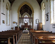
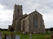 The church at Walcott is dedicated to All Saints
and dates from the middle 14th century. The Font
is 13th century. The font stands on a Celtic limestone memorial slab and both are from an earlier church, the foundations of which may have been discovered in a nearby garden.
During the reign of King Edward I (1239–1307), the church was valued at 20 marks (£13 6s 8d) per year and the Peter pence was 20d.
Originally there were two Halls in Walcott, East Hall and West Hall. William Faden's map of Norfolk dated 1797 shows Walcott Hall but unfortunately it is not entirely clear if this is West or East Hall. However between 1386 & 1486, there is note of a manor called 'Masons' in Walcott.
The de Engain family of Brumstead and Walcott is first noted in 1404 when Thomas de Engain married Margaret, daughter of John Ellis of Great Yarmouth. In 1405, he passed the manor of West Hall to Lord Willoughby and hence West Hall was united to East Hall in Walcott.
In 1360 the Stapleton family of Ingham established a college of Friars of the order of the Holy Trinity and St Victor to serve Ingham and Walcott. Originally it consisted of a Prior
, a Scariest (who acted as Vicar
and lived above the porch) and two brethren. The church is dedicated to the Holy Trinity and was rebuilt in 1360, the Chancel
dates from the 1340s and the Font is 13th century. There is a monument to Sir Oliver de Ingham and Lord & Lady de Boys, there was a brass of Sir Miles Stapleton and his wife.
To help pay for a crusade in the Holy Land
, in 1254 a special tax was introduced called the Norwich Tax. For Walcott the figures were 25 marks (£16 13s 4d) (the Prior of Bromeholm's portion was £1 0s 0d).
Between 1250 and 1350, manorial accounts from Lessingham
suggest that the main agriculture in the vicinity was about 50% Barley
, 20% Legumes, 15% Wheat
and the remaining 15% was Rye
, Oats
and mixed grain. Livestock consisted of about 55% cattle
, 30% sheep and the remaining 15% was horses, oxen and pigs
.
The Nomina Villarum
was a list of lords in 1316 (86) ans shows that Peter Roscelyn & Alexander de Walcott held Lordships in Walcott.
In order to pay for another crusade in the Holy Land, an assessment of tax was made of individual parishes in 1334, which gives an idea of the comparative wealth of each parish
and any changes since the Norwich Taxation of 1254. For Walcott the amount was £6 0s 0d.
The Black Death
arrived in Norfolk in the spring of 1349 and spread up the river valleys from Yarmouth
, suggesting that it arrived by ship and was spread by river craft. In the autumn of 1349, the harvest in the vicinity brought in less than half the usual amount of corn.
High inflation
followed the Black Death as a result of the reduction in the population and the King responded by legally forcing wages down and imposing a Poll (or head) Tax. Needless to say this was very unpopular and there were rebellions in the vicinity (the so-called Peasant's Revolt). Bromholm Priory was attacked and documents were destroyed in June 1381. Eventually the uprising was crushed and in July of 1381 a commission was appointed to deal with the insurgents in Norfolk and Suffolk. There is evidence from their enquiry of the work of a Martham
stonemason in Walcott and Ingham between 1440 & 1470.
 Most parish registers start shortly after the medieval period and in 1603 an incomplete list of church communicants for each parish was compiled. For Walcott the parish registers start in 1558 and there were 110 communicants in 1603. This suggests that Walcott had had an increase in population since 1088.
In August 1797, William Faden published the first comprehensive map of Norfolk that included Walcott. It is not completely to scale but is roughly correct.
In 1830 there was another rebellion due to the introduction of new farming techniques and machinery that put men out of work. The 'Swing riots
' were so called because farmers would receive threatening letters signed by a 'Captain Swing
', whose identity has never been determined. Farm machinery in Walcott was destroyed.
From the Whites Trade Directory dated 1845, Walcott had a population of 172 and 685 acres (2.8 km²) of land. S. Bignold was lord of the manor
. Robert Atkinson was High Constable. There was a Shopkeeper
& Smith
, a Wheelwright
, John Warner ran the Light House Public House and there were seven Farmers
teehee
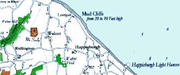
There is access to the beach via:
The nearest railway station is at North Walsham
for the Bittern Line
which runs between Cromer and Norwich.
The nearest airport is Norwich International Airport
.
and a severe European windstorm
caused a storm tide. The area suffered greatly and much of the village was lost to the sea along with neighbouring Keswick
.
hit the East Anglian coast. The sea wall in the village was breached by 12 ft (3.7 m) waves. Property was damaged and boats and caravans were blown across the coast road.
Norfolk
Norfolk is a low-lying county in the East of England. It has borders with Lincolnshire to the west, Cambridgeshire to the west and southwest and Suffolk to the south. Its northern and eastern boundaries are the North Sea coast and to the north-west the county is bordered by The Wash. The county...
coast in England
England
England is a country that is part of the United Kingdom. It shares land borders with Scotland to the north and Wales to the west; the Irish Sea is to the north west, the Celtic Sea to the south west, with the North Sea to the east and the English Channel to the south separating it from continental...
between Mundesley
Mundesley
Mundesley is a coastal village and a civil parish in the English county of Norfolk. The village is 20.3 miles north-north east of Norwich, 7.3 miles south east of Cromer and 136 miles north east of London. The village lies 5.6 miles north-north east of the town of North Walsham. The nearest...
and Happisburgh
Happisburgh
Happisburgh is a village and civil parish in the English county of Norfolk. It is situated off the B1159 coast road from Ingham to Bacton.The civil parish has an area of , although this is declining due to cliff erosion. In the 2001 census, before the creation of Walcott parish, it had a...
.
The name derives from the Celtic word Walecote, which means village by the wood. The village is 19.1 miles (30.7 km) north east of Norwich
Norwich
Norwich is a city in England. It is the regional administrative centre and county town of Norfolk. During the 11th century, Norwich was the largest city in England after London, and one of the most important places in the kingdom...
, 11.9 miles (19.2 km) south east of Cromer
Cromer
Cromer is a coastal town and civil parish in north Norfolk, England. The local government authority is North Norfolk District Council, whose headquarters is in Holt Road in the town. The town is situated 23 miles north of the county town, Norwich, and is 4 miles east of Sheringham...
and 137 miles (220.5 km) north east of London
London
London is the capital city of :England and the :United Kingdom, the largest metropolitan area in the United Kingdom, and the largest urban zone in the European Union by most measures. Located on the River Thames, London has been a major settlement for two millennia, its history going back to its...
. The village lies 5.6 miles (9 km) east of the town of North Walsham
North Walsham
North Walsham is a market town and civil parish in Norfolk, England in the North Norfolk district.-Demographics:The civil parish has an area of and in the 2001 census had a population of 11,998. For the purposes of local government, the parish falls within the district of North...
.
The village is the only point where the B1159
B1159 road
The B1159 is a road in Norfolk, England, running for about between Cromer and Caister-on-Sea, parallel to and at a short distance from the northeastern coast of Norfolk.From north to south the road passes through:*Overstrand*Sidestrand*Trimingham...
(the coast road) actually runs along the edge of the sea. This makes it a popular stopping off point for day-tripper
Day-tripper
A day-tripper is a person who visits a tourist destination or visitor attraction from his/her home and returns home on the same day.- Definition :In other words, this excursion does not involve a night away from home such as experienced on a holiday...
s and storm watchers.
The parish was created in 2008, having formerly been part of Happisburgh parish.
History
This section is adapted from The Historic Happing Website with permission.Geology, geography and climate
The geology and geography in the vicinity of Walcott have been shaped by past ice ages, sea incursions and rivers that have deposited material over the underlying chalk.The last ice sheet left Norfolk around 16,000 BC allowing pine trees to colonise the region.
Between 10,000 - 6000 BC the climate became warm and dry allowing alder, oak, elm & lime into the region.
The increasing temperature caused the sea level to rise and around 5000 BC the North Sea was first connected to the English Channel via a narrow strait. Eventually there were wide inter-tidal estuaries around Norfolk, which started to deposit marine clay over the original peat in the Broadland area.
Around 3000 BC the Norfolk coastline was roughly similar to today's outline, although the local cliffs continued to erode. Some of the eroded material goes to form the sand bar, a few kilometres offshore, that runs parallel with the coastline and is a danger to local shipping.
During the Bronze Age (2,500 - 800 BC) the climate slowly became cooler although the sea level continued to rise and around 750 BC the sea started to breach the spits across the estuaries further south. This resulted in Walcott becoming part of a large peninsula with numerous islands and waterways in the south and east. This peninsula would have made an ideal area for man to colonize with fresh water, fishing and reeds (for thatch) in the west, sea fishing in the east. The good farming land and its isolation would have offered some degree of defence.
From the Iron Age to the end of the Roman period (800 BC - 410 AD) the climate became wet and cold and locally the sea level probably reached about 1.0 m above today's average.
Around 500 AD (during the Anglo-Saxon period) spits of land further south started once again to exclude the sea from the local estuaries and the inlets forming the peninsular began to 'dry out'. These natural barriers have subsequently been maintained by man to protect the farmland behind.
The coastal erosion in the vicinity has been estimated at an approximate rate of 1.0 m per year and accounts for the loss of an approximate 2.0 km wide strip of land since the Roman invasion of AD 43 as a result of which several medieval villages (eg Waxham Parva, Markesthorpe) disappeared into the sea.
Note: Details of the past vegetation and climate of the region have been determined from borehole logs (and pollen analysis) such as that at Ranworth Broad
Ranworth Broad
Ranworth Broad lies in The Broads. It is one of the nature reserves in the care of the Norfolk Wildlife Trust.Ranworth Broad has a floating visitor centre, a boardwalk and a bird observation hide....
.
Prehistoric
The climate was very different during the Palaeolithic or Old Stone Age Era (pre 10,000 BC) as shown by the bones of elephants, rhinoceros, hippopotamus, hyena, etc found in East Anglia. However, it is considered that only intermittent human occupation occurred at this time. The majority of the artefacts recorded in the vicinity of Walcott from this period were flint hand axes, which suggests forest clearance.Little activity is noted in the vicinity during the Mesolithic
Mesolithic
The Mesolithic is an archaeological concept used to refer to certain groups of archaeological cultures defined as falling between the Paleolithic and the Neolithic....
or Middle Stone Age
Middle Stone Age
The Middle Stone Age was a period of African Prehistory between Early Stone Age and Late Stone Age. It is generally considered to have begun around 280,000 years ago and ended around 50-25,000 years ago. The beginnings of particular MSA stone tools have their origins as far back as 550-500,000...
Era (10,000 - 5000 BC) with few artefacts recorded.
During the Neolithic
Neolithic
The Neolithic Age, Era, or Period, or New Stone Age, was a period in the development of human technology, beginning about 9500 BC in some parts of the Middle East, and later in other parts of the world. It is traditionally considered as the last part of the Stone Age...
or New Stone Age Era (5000 - 2500 BC) the majority of the artefacts found in the vicinity are concentrated on higher ground.
The number of Bronze Age
Bronze Age
The Bronze Age is a period characterized by the use of copper and its alloy bronze as the chief hard materials in the manufacture of some implements and weapons. Chronologically, it stands between the Stone Age and Iron Age...
(2500 - 800 BC) artefacts recorded in the vicinity increases significantly from the Neolithic Era and possibly suggests an increase in the population. There is no natural copper or tin ore in Norfolk so all raw materials must have been imported, probably by trading.
Fewer artefacts dating from the Iron Age
Iron Age
The Iron Age is the archaeological period generally occurring after the Bronze Age, marked by the prevalent use of iron. The early period of the age is characterized by the widespread use of iron or steel. The adoption of such material coincided with other changes in society, including differing...
(800 BC - 43 AD), compared to Bronze Age, have been recorded in the vicinity. However, this could just reflect the fact that iron deteriorates faster than bronze. Certainly more Iron Age pottery has been recorded in the vicinity than Bronze Age pottery.
The Norfolk Iron Age tribe were called the Iceni
Iceni
The Iceni or Eceni were a British tribe who inhabited an area of East Anglia corresponding roughly to the modern-day county of Norfolk between the 1st century BC and the 1st century AD...
and probably consisted of a group of smaller tribes, as in 54 BC Julius Caesar describes then as the Cenimagni - the Greater Iceni. It is possible that east Norfolk (including Walcott) may have been occupied by one of these smaller (possibly poorer) tribes, which could explain the general lack of finds. Some historians consider that the west side of Norfolk was settled before the east side and that society underwent a progressive fragmentation during the Iron Age until around 60 BC when larger groups started to emerge.
Roman
The number of artefacts recorded in the vicinity increases significantly during the Roman occupation (43 AD - 410 AD) with a small concentration on high ground near Happisburgh and large concentrations around the StalhamStalham
Stalham is a market town on the River Ant in the English county of Norfolk, in East Anglia. It covers an area of and had a population of 2,951 in 1,333 households as of the 2001 census. It lies within the Norfolk Broads, about north-east of Norwich on the A149 road.For the purposes of local...
/Ingham
Ingham, Norfolk
Ingham is a small village and civil parish in the English county of Norfolk. It lies close to the village of Stalham, and is about 2 miles from Sea Palling on the North Sea coast....
/Wayford area.
Of the datable Roman artefacts recorded in the vicinity, approximately 75% are 1st and 2nd century AD and 25% are 3rd and 4th century AD. This discrepancy may suggest a decline in Roman activity in the vicinity from around AD 200. The Roman historian Ammianus Marcellinus
Ammianus Marcellinus
Ammianus Marcellinus was a fourth-century Roman historian. He wrote the penultimate major historical account surviving from Antiquity...
records barbarians harassing Britain's east coast in AD 367.
Dark Ages
The vicinity shows economic recession and technological regression in the post Roman period. Grave goods found from this period strongly suggest a large influx of people from the AnglianAngles
The Angles is a modern English term for a Germanic people who took their name from the ancestral cultural region of Angeln, a district located in Schleswig-Holstein, Germany...
region of Schleswig
Schleswig
Schleswig or South Jutland is a region covering the area about 60 km north and 70 km south of the border between Germany and Denmark; the territory has been divided between the two countries since 1920, with Northern Schleswig in Denmark and Southern Schleswig in Germany...
in north Germany/south Denmark (the Angles), confirmed by the Venerable Bede.
During the Middle Saxon period (AD 650 - 865), the archaeological evidence in Norfolk changes (shortly after AD 700) and suggests that the region was arguably more Christian
Christian
A Christian is a person who adheres to Christianity, an Abrahamic, monotheistic religion based on the life and teachings of Jesus of Nazareth as recorded in the Canonical gospels and the letters of the New Testament...
than pagan
Paganism
Paganism is a blanket term, typically used to refer to non-Abrahamic, indigenous polytheistic religious traditions....
.
Late Anglo-Saxon (865 - 1066) artefacts recorded in the vicinity are few in number but of high quality and are indicative of high status.
Viking forces first raided East Anglia in 865 and it remained under Scandinavian control until 917 when the West Saxons re-conquered East Anglia. It is thought that this was the start of the system of Hundreds - areas of land containing approximately 100 families. Walcott is in the Happing Hundred.
Local place names often date from this period and can suggest past land use, people, features, etc. For example Walcott - Serf or Foreigner's cottage
.
The cutting of peat
Peat
Peat is an accumulation of partially decayed vegetation matter or histosol. Peat forms in wetland bogs, moors, muskegs, pocosins, mires, and peat swamp forests. Peat is harvested as an important source of fuel in certain parts of the world...
that resulted in the formation of the Broads
The Broads
The Broads are a network of mostly navigable rivers and lakes in the English counties of Norfolk and Suffolk. The Broads, and some surrounding land were constituted as a special area with a level of protection similar to a UK National Park by The Norfolk and Suffolk Broads Act of 1988...
is thought to have started around AD 900. This practice may have been introduced by the Angles and could indicate the scarcity of firewood at the time.
Medieval
Moving from the Dark Ages into the medieval period, documentary evidence takes precedence over archaeological evidence.Before the Norman Conquest
Norman conquest of England
The Norman conquest of England began on 28 September 1066 with the invasion of England by William, Duke of Normandy. William became known as William the Conqueror after his victory at the Battle of Hastings on 14 October 1066, defeating King Harold II of England...
Walcott was held by Eadric de Laxfield. There were 4 carucates and 6 acres (about 486 acres) of (arable) land, 8 villagers and 16 smallholders. The lord had 2 ploughs and there were 2 other ploughs. There were 8 acres (32,374.9 m²) of meadow, 1 mill, 3 cattle, 4 pigs & 80 sheep. There was a church with 20 acres (80,937.2 m²). There were 7 freemen with 70 acres (283,280.2 m²) and 2 ploughs, and there were 5 other ploughs. The value of the manor was 40 shillings. South Erpingham Hundred held 3 freemen in Walcott with 90 acres (364,217.4 m²) and 3 ploughs.
Eadric was a major Thane
Thegn
The term thegn , from OE þegn, ðegn "servant, attendant, retainer", is commonly used to describe either an aristocratic retainer of a king or nobleman in Anglo-Saxon England, or as a class term, the majority of the aristocracy below the ranks of ealdormen and high-reeves...
(noble) at that time, based at Eye
Eye, Suffolk
Eye is a small market town in the county of Suffolk, East Anglia, England, south of Diss, and on the River Dove.Eye is twinned with the town of Pouzauges in the Vendée Departement of France.-History:An island...
in Suffolk
Suffolk
Suffolk is a non-metropolitan county of historic origin in East Anglia, England. It has borders with Norfolk to the north, Cambridgeshire to the west and Essex to the south. The North Sea lies to the east...
, with numerous manors and lands in Norfolk, Suffolk and Wiltshire
Wiltshire
Wiltshire is a ceremonial county in South West England. It is landlocked and borders the counties of Dorset, Somerset, Hampshire, Gloucestershire, Oxfordshire and Berkshire. It contains the unitary authority of Swindon and covers...
. Whilst some historians consider him to have been Danish, as depicted on the village sign at Happisburgh, all (admittedly slender) evidence relating to his origin suggests that he was English.
Immediately after the Conquest Walcott was given to Robert Malet
Robert Malet
Robert Malet was an English/ Norman baron and a close advisor of Henry I.-Biography:Malet was the son of William Malet, and inherited his father's great honour of Eye in 1071. This made him one of the dozen or so greatest landholders in England...
who died before the Domesday Survey of 1088 when it was granted to Ralph (Ranulf), brother of Iger and held by Humphrey, possibly his nephew. There were 4 carucates and 6 acres (24,281.2 m²) of land with 3 ploughs, 8 villagers & 16 smallholders. 2 other ploughs, 8 acres (32,374.9 m²) of meadow, 1 mill, 2 cobs (horses), 16 cattle, 24 pigs, 70 sheep & 4 beehives. 1 church with 20 acres (80,937.2 m²), 7 freemen with 70 acres (283,280.2 m²), 5 other ploughs. Another 4 freemen with 90 acres (364,217.4 m²). The value of the manor was 60s. South Erpingham Hundred held 3 freemen in Walcott with 2.5 ploughs. As only men were recorded in the survey, and assuming each man had a wife and 2.4 children, the approximate population of Walcott in 1088 was around 170.
The eponymous de Walcott family
De Walcott family
The de Walcott family were Lords of the Manor of Walcott from the late 12th century until the late 14th century.This article is adapted from with permission.-Manor houses:...
were Lords of the Manor
Lord of the Manor
The Lordship of a Manor is recognised today in England and Wales as a form of property and one of three elements of a manor that may exist separately or be combined and may be held in moieties...
of Walcott from about the late 12th century until about the late 14th century.
All Saints
All Saints' Day , often shortened to All Saints, is a solemnity celebrated on 1 November by parts of Western Christianity, and on the first Sunday after Pentecost in Eastern Christianity, in honour of all the saints, known and unknown...
and dates from the middle 14th century. The Font
Baptismal font
A baptismal font is an article of church furniture or a fixture used for the baptism of children and adults.-Aspersion and affusion fonts:...
is 13th century. The font stands on a Celtic limestone memorial slab and both are from an earlier church, the foundations of which may have been discovered in a nearby garden.
During the reign of King Edward I (1239–1307), the church was valued at 20 marks (£13 6s 8d) per year and the Peter pence was 20d.
Originally there were two Halls in Walcott, East Hall and West Hall. William Faden's map of Norfolk dated 1797 shows Walcott Hall but unfortunately it is not entirely clear if this is West or East Hall. However between 1386 & 1486, there is note of a manor called 'Masons' in Walcott.
The de Engain family of Brumstead and Walcott is first noted in 1404 when Thomas de Engain married Margaret, daughter of John Ellis of Great Yarmouth. In 1405, he passed the manor of West Hall to Lord Willoughby and hence West Hall was united to East Hall in Walcott.
In 1360 the Stapleton family of Ingham established a college of Friars of the order of the Holy Trinity and St Victor to serve Ingham and Walcott. Originally it consisted of a Prior
Prior
Prior is an ecclesiastical title, derived from the Latin adjective for 'earlier, first', with several notable uses.-Monastic superiors:A Prior is a monastic superior, usually lower in rank than an Abbot. In the Rule of St...
, a Scariest (who acted as Vicar
Vicar
In the broadest sense, a vicar is a representative, deputy or substitute; anyone acting "in the person of" or agent for a superior . In this sense, the title is comparable to lieutenant...
and lived above the porch) and two brethren. The church is dedicated to the Holy Trinity and was rebuilt in 1360, the Chancel
Chancel
In church architecture, the chancel is the space around the altar in the sanctuary at the liturgical east end of a traditional Christian church building...
dates from the 1340s and the Font is 13th century. There is a monument to Sir Oliver de Ingham and Lord & Lady de Boys, there was a brass of Sir Miles Stapleton and his wife.
To help pay for a crusade in the Holy Land
Holy Land
The Holy Land is a term which in Judaism refers to the Kingdom of Israel as defined in the Tanakh. For Jews, the Land's identifiction of being Holy is defined in Judaism by its differentiation from other lands by virtue of the practice of Judaism often possible only in the Land of Israel...
, in 1254 a special tax was introduced called the Norwich Tax. For Walcott the figures were 25 marks (£16 13s 4d) (the Prior of Bromeholm's portion was £1 0s 0d).
Between 1250 and 1350, manorial accounts from Lessingham
Lessingham
Lessingham is a village and a civil parish in the English county of Norfolk. The village is 16.3 south-east of Cromer, 17.6 miles north-east of Norwich and 136 miles north-east of London. The village lies 9 miles south-east of the town of North Walsham. The nearest railway station is at Worstead...
suggest that the main agriculture in the vicinity was about 50% Barley
Barley
Barley is a major cereal grain, a member of the grass family. It serves as a major animal fodder, as a base malt for beer and certain distilled beverages, and as a component of various health foods...
, 20% Legumes, 15% Wheat
Wheat
Wheat is a cereal grain, originally from the Levant region of the Near East, but now cultivated worldwide. In 2007 world production of wheat was 607 million tons, making it the third most-produced cereal after maize and rice...
and the remaining 15% was Rye
Rye
Rye is a grass grown extensively as a grain and as a forage crop. It is a member of the wheat tribe and is closely related to barley and wheat. Rye grain is used for flour, rye bread, rye beer, some whiskeys, some vodkas, and animal fodder...
, Oats
OATS
OATS - Open Source Assistive Technology Software - is a source code repository or "forge" for assistive technology software. It was launched in 2006 with the goal to provide a one-stop “shop” for end users, clinicians and open-source developers to promote and develop open source assistive...
and mixed grain. Livestock consisted of about 55% cattle
Cattle
Cattle are the most common type of large domesticated ungulates. They are a prominent modern member of the subfamily Bovinae, are the most widespread species of the genus Bos, and are most commonly classified collectively as Bos primigenius...
, 30% sheep and the remaining 15% was horses, oxen and pigs
PIGS
PIGS is a four letter acronym that can stand for:* PIGS , Phosphatidylinositol glycan anchor biosynthesis, class S, a human gene* PIGS , the economies of Portugal, Italy , Greece and Spain...
.
The Nomina Villarum
Nomina Villarum
Nomina Villarum was a survey carried out in 1316 and contains a list of all cities, boroughs and townships in England and the Lords of them. The document was compiled for King Edward II...
was a list of lords in 1316 (86) ans shows that Peter Roscelyn & Alexander de Walcott held Lordships in Walcott.
In order to pay for another crusade in the Holy Land, an assessment of tax was made of individual parishes in 1334, which gives an idea of the comparative wealth of each parish
Parish
A parish is a territorial unit historically under the pastoral care and clerical jurisdiction of one parish priest, who might be assisted in his pastoral duties by a curate or curates - also priests but not the parish priest - from a more or less central parish church with its associated organization...
and any changes since the Norwich Taxation of 1254. For Walcott the amount was £6 0s 0d.
The Black Death
Black Death
The Black Death was one of the most devastating pandemics in human history, peaking in Europe between 1348 and 1350. Of several competing theories, the dominant explanation for the Black Death is the plague theory, which attributes the outbreak to the bacterium Yersinia pestis. Thought to have...
arrived in Norfolk in the spring of 1349 and spread up the river valleys from Yarmouth
Great Yarmouth
Great Yarmouth, often known to locals as Yarmouth, is a coastal town in Norfolk, England. It is at the mouth of the River Yare, east of Norwich.It has been a seaside resort since 1760, and is the gateway from the Norfolk Broads to the sea...
, suggesting that it arrived by ship and was spread by river craft. In the autumn of 1349, the harvest in the vicinity brought in less than half the usual amount of corn.
High inflation
Inflation
In economics, inflation is a rise in the general level of prices of goods and services in an economy over a period of time.When the general price level rises, each unit of currency buys fewer goods and services. Consequently, inflation also reflects an erosion in the purchasing power of money – a...
followed the Black Death as a result of the reduction in the population and the King responded by legally forcing wages down and imposing a Poll (or head) Tax. Needless to say this was very unpopular and there were rebellions in the vicinity (the so-called Peasant's Revolt). Bromholm Priory was attacked and documents were destroyed in June 1381. Eventually the uprising was crushed and in July of 1381 a commission was appointed to deal with the insurgents in Norfolk and Suffolk. There is evidence from their enquiry of the work of a Martham
Martham
Martham is a village and civil parish in the English county of Norfolk and within the Broads National Park. It is situated some north-west of the town of Great Yarmouth and north-east of the city of Norwich....
stonemason in Walcott and Ingham between 1440 & 1470.
Post Medieval
In August 1797, William Faden published the first comprehensive map of Norfolk that included Walcott. It is not completely to scale but is roughly correct.
In 1830 there was another rebellion due to the introduction of new farming techniques and machinery that put men out of work. The 'Swing riots
Swing Riots
The Swing Riots were a widespread uprising by agricultural workers; it began with the destruction of threshing machines in the Elham Valley area of East Kent in the summer of 1830, and by early December had spread throughout the whole of southern England and East Anglia.As well as the attacks on...
' were so called because farmers would receive threatening letters signed by a 'Captain Swing
Captain Swing
Captain Swing was the name appended to some of the threatening letters during the rural English Swing Riots of 1830, when labourers rioted over the introduction of new threshing machines and the loss of their livelihoods...
', whose identity has never been determined. Farm machinery in Walcott was destroyed.
From the Whites Trade Directory dated 1845, Walcott had a population of 172 and 685 acres (2.8 km²) of land. S. Bignold was lord of the manor
Lord of the Manor
The Lordship of a Manor is recognised today in England and Wales as a form of property and one of three elements of a manor that may exist separately or be combined and may be held in moieties...
. Robert Atkinson was High Constable. There was a Shopkeeper
Shopkeeper
A shopkeeper is an individual who owns a shop. Generally, shop employees are not shopkeepers, but are often incorrectly referred to as shopkeepers. Today, a shopkeeper is usually referred to as a manager, though this term could apply to larger firms .*In many south asian languages like Hindi, Urdu,...
& Smith
Smith (metalwork)
A metalsmith, often shortened to smith, is a person involved in making metal objects. In contemporary use a metalsmith is a person who uses metal as a material, uses traditional metalsmithing techniques , whose work thematically relates to the practice or history of the practice, or who engages in...
, a Wheelwright
Wheelwright
A wheelwright is a person who builds or repairs wheels. The word is the combination of "wheel" and the archaic word "wright", which comes from the Old English word "wryhta", meaning a worker or maker...
, John Warner ran the Light House Public House and there were seven Farmers
teehee
Village amenities
The village has a parish church (All Saints, 14th - 15th century), 2 shops (one incorporating a sub-post office), several restaurants and pubs, a caravan site and an infant school.There is access to the beach via:
- Walcott Gap, a wooden slipway that runs from the road to the sand and which can accommodate cars or tractors, and trailers, allowing for the launching of small craft including local fishing boats.
- Steps set into the sea defences at several points along the sea front.
Public transport
There is an infrequent bus service through the village connecting it to North Walsham via a circular route.The nearest railway station is at North Walsham
North Walsham railway station
North Walsham is a railway station in the town of North Walsham in the English county of Norfolk. The station is served by local services operated by National Express East Anglia on the Bittern Line from Norwich to Cromer and Sheringham...
for the Bittern Line
Bittern Line
The Bittern Line is a railway line from Norwich to Cromer then Sheringham in Norfolk, England. It is one of the most scenic in the East of England traversing the Norfolk Broads on its route to the Area of Outstanding Natural Beauty on the North Norfolk Coast. The line is part of the Network Rail...
which runs between Cromer and Norwich.
The nearest airport is Norwich International Airport
Norwich International Airport
Norwich International Airport , also known as Norwich Airport, is an airport in the City of Norwich within Norfolk, England north of the city centre and on the edge of the city's suburbs....
.
North Sea flood of 1953
On the night of 31 January 1953 a combination of a high spring tideTide
Tides are the rise and fall of sea levels caused by the combined effects of the gravitational forces exerted by the moon and the sun and the rotation of the Earth....
and a severe European windstorm
European windstorm
A European windstorm is a severe cyclonic windstorm associated with areas of low atmospheric pressure that track across the North Atlantic towards northwestern Europe. They are most common in the winter months...
caused a storm tide. The area suffered greatly and much of the village was lost to the sea along with neighbouring Keswick
Bacton, Norfolk
Bacton is a village and civil parish in Norfolk, England. It is on the Norfolk coast, some 20 km south-east of Cromer, 40 km north-west of Great Yarmouth and 30 km north of Norwich. Besides the village of Bacton, the parish includes the nearby settlements of Bacton Green, Broomholm,...
.
North Sea flood of 2007
On November 10, 2007 a storm surgeStorm surge
A storm surge is an offshore rise of water associated with a low pressure weather system, typically tropical cyclones and strong extratropical cyclones. Storm surges are caused primarily by high winds pushing on the ocean's surface. The wind causes the water to pile up higher than the ordinary sea...
hit the East Anglian coast. The sea wall in the village was breached by 12 ft (3.7 m) waves. Property was damaged and boats and caravans were blown across the coast road.