

Via Flaminia
Encyclopedia
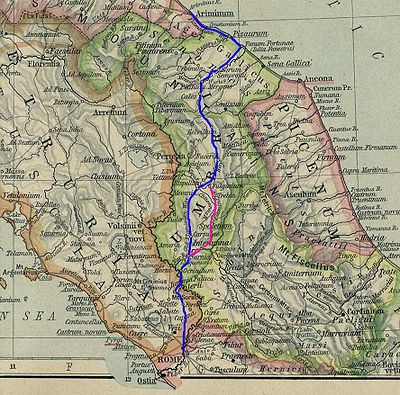
Roman road
The Roman roads were a vital part of the development of the Roman state, from about 500 BC through the expansion during the Roman Republic and the Roman Empire. Roman roads enabled the Romans to move armies and trade goods and to communicate. The Roman road system spanned more than 400,000 km...
leading from Rome
Rome
Rome is the capital of Italy and the country's largest and most populated city and comune, with over 2.7 million residents in . The city is located in the central-western portion of the Italian Peninsula, on the Tiber River within the Lazio region of Italy.Rome's history spans two and a half...
over the Apennine Mountains
Apennine mountains
The Apennines or Apennine Mountains or Greek oros but just as often used alone as a noun. The ancient Greeks and Romans typically but not always used "mountain" in the singular to mean one or a range; thus, "the Apennine mountain" refers to the entire chain and is translated "the Apennine...
to Ariminum (Rimini
Rimini
Rimini is a medium-sized city of 142,579 inhabitants in the Emilia-Romagna region of Italy, and capital city of the Province of Rimini. It is located on the Adriatic Sea, on the coast between the rivers Marecchia and Ausa...
) on the coast of the Adriatic Sea
Adriatic Sea
The Adriatic Sea is a body of water separating the Italian Peninsula from the Balkan peninsula, and the system of the Apennine Mountains from that of the Dinaric Alps and adjacent ranges...
, and due to the ruggedness of the mountains was the major option the Romans had for travel between Etruria
Etruria
Etruria—usually referred to in Greek and Latin source texts as Tyrrhenia—was a region of Central Italy, an area that covered part of what now are Tuscany, Latium, Emilia-Romagna, and Umbria. A particularly noteworthy work dealing with Etruscan locations is D. H...
, Latium
Latium
Lazio is one of the 20 administrative regions of Italy, situated in the central peninsular section of the country. With about 5.7 million residents and a GDP of more than 170 billion euros, Lazio is the third most populated and the second richest region of Italy...
and Campania
Campania
Campania is a region in southern Italy. The region has a population of around 5.8 million people, making it the second-most-populous region of Italy; its total area of 13,590 km² makes it the most densely populated region in the country...
and the Po Valley
Po Valley
The Po Valley, Po Plain, Plain of the Po, or Padan Plain is a major geographical feature of Italy. It extends approximately in an east-west direction, with an area of 46,000 km² including its Venetic extension not actually related to the Po River basin; it runs from the Western Alps to the...
. Today the same route, still called by the same name for much of its distance, is paralleled or overlain by Strada Statale (SS) 3, also called Strada Regionale (SR) 3 in Lazio and Umbria
Umbria
Umbria is a region of modern central Italy. It is one of the smallest Italian regions and the only peninsular region that is landlocked.Its capital is Perugia.Assisi and Norcia are historical towns associated with St. Francis of Assisi, and St...
, and Strada Provinciale (SP) 3 in Marche
Marche
The population density in the region is below the national average. In 2008, it was 161.5 inhabitants per km2, compared to the national figure of 198.8. It is highest in the province of Ancona , and lowest in the province of Macerata...
. It leaves Rome, goes up the Val Tevere ("Valley of the Tiber River"), strikes into the mountains at Castello delle Formische, ascends to Gualdo Tadino
Gualdo Tadino
Gualdo Tadino, an ancient town of Italy, in the province of Perugia in northeastern Umbria, on the lower flanks of Mt. Penna, a mountain of the Apennines. It is 47 km NE of Perugia and 30 km SE of Gubbio....
, goes over the divide at Scheggia Pass
Scheggia Pass
The Scheggia Pass is a pass in Italy that marks the division between the Central and Northern Apennines. It is in northern Umbria and lies between Gubbio and Cagli at 575 meters ....
, 575 m (1,886.5 ft), to Cagli
Cagli
Cagli is a town and comune in the province of Pesaro e Urbino, Marche, central Italy. It c. 30 km south of Urbino.-History:Cagli occupies the site of an ancient village on the Via Flaminia, which seems to have borne the name Cale, 24 miles north of Helvillum and 18 miles southwest of Forum...
. From there it descends the eastern slope waterways between the Tuscan-Emilian Apennines and the Umbrian Apennines to Fano
Fano
Fano is a town and comune of the province of Pesaro and Urbino in the Marche region of Italy. It is a beach resort 12 km southeast of Pesaro, located where the Via Flaminia reaches the Adriatic Sea...
on the coast and goes north parallel to Highway A1 to Rimini
Rimini
Rimini is a medium-sized city of 142,579 inhabitants in the Emilia-Romagna region of Italy, and capital city of the Province of Rimini. It is located on the Adriatic Sea, on the coast between the rivers Marecchia and Ausa...
.
This route, convenient to ancients, is far from it to heavy modern traffic between north Italy and the capital. It remains a country road, while the traffic crosses by railway and autostrada through dozens of tunnels between Florence
Florence
Florence is the capital city of the Italian region of Tuscany and of the province of Florence. It is the most populous city in Tuscany, with approximately 370,000 inhabitants, expanding to over 1.5 million in the metropolitan area....
and Bologna
Bologna
Bologna is the capital city of Emilia-Romagna, in the Po Valley of Northern Italy. The city lies between the Po River and the Apennine Mountains, more specifically, between the Reno River and the Savena River. Bologna is a lively and cosmopolitan Italian college city, with spectacular history,...
, a shorter, more direct route under the ridges and nearly inaccessible passes.
History
It was constructed by Gaius FlaminiusGaius Flaminius
Gaius Flaminius Nepos was a politician and consul of the Roman Republic in the 3rd century BC. He was the greatest popular leader to challenge the authority of the Senate before the Gracchi a century later....
during his censor
Censor (ancient Rome)
The censor was an officer in ancient Rome who was responsible for maintaining the census, supervising public morality, and overseeing certain aspects of the government's finances....
ship (220 BC). Sources mention frequent improvements being made to it during the imperial period. Augustus
Augustus
Augustus ;23 September 63 BC – 19 August AD 14) is considered the first emperor of the Roman Empire, which he ruled alone from 27 BC until his death in 14 AD.The dates of his rule are contemporary dates; Augustus lived under two calendars, the Roman Republican until 45 BC, and the Julian...
, when he instituted a general restoration of the roads of Italy, which he assigned for the purpose among various senators
Roman Senate
The Senate of the Roman Republic was a political institution in the ancient Roman Republic, however, it was not an elected body, but one whose members were appointed by the consuls, and later by the censors. After a magistrate served his term in office, it usually was followed with automatic...
, reserved the Flaminia for himself, and rebuilt all the bridges except the Pons Mulvius
Ponte Milvio
The Milvian Bridge is a bridge over the Tiber in northern Rome, Italy. It was an economically and strategically important bridge in the era of the Roman Empire and was the site of the famous Battle of Milvian Bridge....
, by which it crosses the Tiber
Tiber
The Tiber is the third-longest river in Italy, rising in the Apennine Mountains in Emilia-Romagna and flowing through Umbria and Lazio to the Tyrrhenian Sea. It drains a basin estimated at...
, 3 km (2 mi) north of Rome (built by Marcus Aemilius Scaurus
Marcus Aemilius Scaurus
Marcus Aemilius Scaurus was a Roman consul in 115 BC and considered one of the most talented and influential politicians of the Republic....
in 109 BC), and an unknown Pons Minucius. Triumphal arches were erected in his honour on the former bridge and at Ariminum, the latter of which is still preserved. Vespasian
Vespasian
Vespasian , was Roman Emperor from 69 AD to 79 AD. Vespasian was the founder of the Flavian dynasty, which ruled the Empire for a quarter century. Vespasian was descended from a family of equestrians, who rose into the senatorial rank under the Emperors of the Julio-Claudian dynasty...
constructed a new tunnel through the pass of Intercisa (Furlo), in 77, and Trajan
Trajan
Trajan , was Roman Emperor from 98 to 117 AD. Born into a non-patrician family in the province of Hispania Baetica, in Spain Trajan rose to prominence during the reign of emperor Domitian. Serving as a legatus legionis in Hispania Tarraconensis, in Spain, in 89 Trajan supported the emperor against...
, as inscriptions show, repaired several bridges along the road.
In the Middle Ages
Middle Ages
The Middle Ages is a periodization of European history from the 5th century to the 15th century. The Middle Ages follows the fall of the Western Roman Empire in 476 and precedes the Early Modern Era. It is the middle period of a three-period division of Western history: Classic, Medieval and Modern...
it was known as the Ravenna road, as it led to the then more important city of Ravenna
Ravenna
Ravenna is the capital city of the Province of Ravenna in the Emilia-Romagna region of Italy and the second largest comune in Italy by land area, although, at , it is little more than half the size of the largest comune, Rome...
. Following the end of the Exarchate of Ravenna
Exarchate of Ravenna
The Exarchate of Ravenna or of Italy was a centre of Byzantine power in Italy, from the end of the 6th century to 751, when the last exarch was put to death by the Lombards.-Introduction:...
, it fell into disuse during the Lombard
Lombards
The Lombards , also referred to as Longobards, were a Germanic tribe of Scandinavian origin, who from 568 to 774 ruled a Kingdom in Italy...
period, but was partially reconstructed in the Renaissance
Renaissance
The Renaissance was a cultural movement that spanned roughly the 14th to the 17th century, beginning in Italy in the Late Middle Ages and later spreading to the rest of Europe. The term is also used more loosely to refer to the historical era, but since the changes of the Renaissance were not...
era and continued to be of military importance down to the Napoleonic era
Napoleon I
Napoleon Bonaparte was a French military and political leader during the latter stages of the French Revolution.As Napoleon I, he was Emperor of the French from 1804 to 1815...
and World War II
World War II
World War II, or the Second World War , was a global conflict lasting from 1939 to 1945, involving most of the world's nations—including all of the great powers—eventually forming two opposing military alliances: the Allies and the Axis...
. As the SS 3 (Strada Statale 3) it remains one of the principal highways from Rome to the Adriatic.
The importance of the ancient Via Flaminia is twofold: during the period of Roman expansion in the 3rd and 2nd centuries BC, the Flaminia became, with the cheaper sea route, a main axis of transportation by which wheat from the Po valley
Po Valley
The Po Valley, Po Plain, Plain of the Po, or Padan Plain is a major geographical feature of Italy. It extends approximately in an east-west direction, with an area of 46,000 km² including its Venetic extension not actually related to the Po River basin; it runs from the Western Alps to the...
supplied Rome and central Italy; during the period of Roman decline, the Flaminia was the main road leading into the heartland of Italy: it was taken by Julius Caesar
Julius Caesar
Gaius Julius Caesar was a Roman general and statesman and a distinguished writer of Latin prose. He played a critical role in the gradual transformation of the Roman Republic into the Roman Empire....
at the beginning of the civil war
Caesar's civil war
The Great Roman Civil War , also known as Caesar's Civil War, was one of the last politico-military conflicts in the Roman Republic before the establishment of the Roman Empire...
, but also by various barbarian hordes, Byzantine generals, etc. A number of major battles were therefore fought on or near the Via Flaminia, for example at Sentinum
Sentinum
Sentinum was an ancient town of currently located in the Marche region in Italy, lying a kilometre in the low ground at the east of the existing town of Sassoferrato. Its ruins were identified in 1890 and published by T...
(near the modern Sassoferrato
Sassoferrato
Sassoferrato is a town and comune of the province of Ancona in the Marche region of Italy.-History:To the south of the town lie the ruins of the ancient Sentinum, on the Via Flaminia...
) and near Tadinum (the modern Gualdo Tadino
Gualdo Tadino
Gualdo Tadino, an ancient town of Italy, in the province of Perugia in northeastern Umbria, on the lower flanks of Mt. Penna, a mountain of the Apennines. It is 47 km NE of Perugia and 30 km SE of Gubbio....
). In the early Middle Ages, the road, controlled by the Eastern Empire
Byzantine Empire
The Byzantine Empire was the Eastern Roman Empire during the periods of Late Antiquity and the Middle Ages, centred on the capital of Constantinople. Known simply as the Roman Empire or Romania to its inhabitants and neighbours, the Empire was the direct continuation of the Ancient Roman State...
, was a civilizing influence, and accounted for much of what historians call the "Byzantine corridor".
Ancient route
The Via Flaminia starts at Porta del Popolo in the Aurelian WallsAurelian Walls
The Aurelian Walls is a line of city walls built between 271 and 275 in Rome, Italy, during the reign of the Roman Emperors Aurelian and Probus....
of Rome: Via del Corso
Via del Corso
The Via del Corso , commonly known as the Corso, is a main street in the historical centre of Rome. It is remarkable for being absolutely straight in an area characterized by narrow meandering alleys and small piazzas...
(Via Lata), which connects the Campidoglio to the gate, can be considered the urban stretch of the Via Flaminia. The road then runs due north, considerable remains of its pavement being extant under the modern road, passing slightly east of the site of the Etruscan
Etruscan civilization
Etruscan civilization is the modern English name given to a civilization of ancient Italy in the area corresponding roughly to Tuscany. The ancient Romans called its creators the Tusci or Etrusci...
Falerii (Civita Castellana
Civita Castellana
Civita Castellana is a town and comune in the province of Viterbo, 65 km north of Rome.Mount Soracte lies about 10 km to the south-east.-History:...
), crossing the Tiber into Umbria over a bridge some slight vestiges of which can still be seen, the "Pile d' Augusto". From there it made its way to Ocriculum (Otricoli
Otricoli
Otricoli is a town and comune in the province of Terni, Umbria, Italy. It is located on the Via Flaminia, near the east bank of the Tiber, 44 miles north of Rome and 12 miles south of Narni.-History and landmarks:...
) and Narnia (Narni
Narni
Narni is an ancient hilltown and comune of Umbria, in central Italy, with 20,100 inhabitants, according to the 2003 census. At an altitude of 240 m , it overhangs a narrow gorge of the Nera River in the province of Terni. It is very close to the Geographic center of Italy...
), where it crossed the Nera River
Nera River (Italy)
The Nera is a 116 km long river which flows almost entirely in Umbria, Italy. A tributary to the Tiber, its sources are in the Monti Sibillini, east of Foligno. It flows southward past Terni and Narni. It joins the Tiber near Orte.-See also:...
by the largest Roman bridge ever built, a splendid four-arched structure to which Martial
Martial
Marcus Valerius Martialis , was a Latin poet from Hispania best known for his twelve books of Epigrams, published in Rome between AD 86 and 103, during the reigns of the emperors Domitian, Nerva and Trajan...
alludes, one arch of which and all the piers are still standing; and went on, followed at first by the modern road to Casuentum (San Gemini
San Gemini
San Gemini is a comune of c. 4,500 inhabitants in the province of Terni in the Italian region Umbria, located about 60 km south of Perugia and about 10 km northwest of Terni....
) which passes over two finely preserved ancient bridges, through Carsulae
Carsulae
Carsulae is an archaeological site in Umbria, central Italy, now one of the most important archaeological ruins in Italy. It is located c. 4 km north of San Gemini, a small comune in the province of Terni. Nearby is the comune of Montecastrilli .-Origins and history:Most historians fix the...
to Mevania
Mevania
Mevania , an ancient Roman town and municipium of , in the Augustan Regio VI. It lay on the western branch of the Via Flaminia, 13 km WSW of Forum Flaminii where the branches rejoin....
(Bevagna
Bevagna
Bevagna is a town and comune in the central part of the Italian province of Perugia, , in the flood plain of the Topino river.Bevagna is 25 km SE of Perugia, 8 km west of Foligno, 7 km north-north-west of Montefalco, 16 km south of Assisi and 15 km north-west of Trevi.It...
), and thence to Forum Flaminii (S. Giovanni Profiamma). Later, a more circuitous route from Narnia to Forum Flaminii was adopted, increasing the distance by 12 Roman miles (18 km) and passing by Interamna Nahars (Terni
Terni
Terni is a city in southern Umbria, central Italy, capital of the province of Terni, located in the plain of the Nera river. It is 104 km N of Rome, 36 km NW of Rieti, and 29 km S of Spoleto.-History:...
), Spoletium (Spoleto
Spoleto
Spoleto is an ancient city in the Italian province of Perugia in east central Umbria on a foothill of the Apennines. It is S. of Trevi, N. of Terni, SE of Perugia; SE of Florence; and N of Rome.-History:...
) and Fulginium (Foligno
Foligno
Foligno is an ancient town of Italy in the province of Perugia in east central Umbria, on the Topino river where it leaves the Apennines and enters the wide plain of the Clitunno river system...
) — from which a branch diverged to Perusia (Perugia
Perugia
Perugia is the capital city of the region of Umbria in central Italy, near the River Tiber, and the capital of the province of Perugia. The city is located about north of Rome. It covers a high hilltop and part of the valleys around the area....
).
From Forum Flaminii the Flaminia went on to Nuceria Camellaria (Nocera Umbra) — whence a branch road ran to Septempeda and thence either to Ancona
Ancona
Ancona is a city and a seaport in the Marche region, in central Italy, with a population of 101,909 . Ancona is the capital of the province of Ancona and of the region....
or to Tolentinum (Tolentino
Tolentino
Tolentino is a town and comune of about 20,000 inhabitants, in the province of Macerata in the Marche region of central Italy.It is located in the middle of the valley of the Chienti.-History:...
) and Urbs Salvia (Urbisaglia
Urbisaglia
Urbisaglia is a comune in the province of Macerata, Marche, Italy. Its name comes from the ancient Roman town Urbs Salvia.-History:Situated in the Regio V Picenum, along the via Salaria Gallica, the town was founded during the 2nd century BC as a colonia...
) — and Helvillum (site uncertain, probably Sigillo
Sigillo
Sigillo is a comune in the province of Perugia in the Italian region Umbria, located about 35 km northeast of Perugia.Sigillo borders the following municipalities: Costacciaro, Fabriano, Fossato di Vico, Gubbio.-History:...
, but maybe Fossato di Vico
Fossato di Vico
Fossato di Vico is a town and comune of Umbria in the province of Perugia in Italy,, at 581 m above sea‑level on the middle slopes of Mount Mutali....
), to cross the main ridge of the Apennines
Apennine mountains
The Apennines or Apennine Mountains or Greek oros but just as often used alone as a noun. The ancient Greeks and Romans typically but not always used "mountain" in the singular to mean one or a range; thus, "the Apennine mountain" refers to the entire chain and is translated "the Apennine...
, a temple of Jupiter Apenninus standing at or near the summit of the pass according to one ancient author. From there it descended to Cales (Cagli
Cagli
Cagli is a town and comune in the province of Pesaro e Urbino, Marche, central Italy. It c. 30 km south of Urbino.-History:Cagli occupies the site of an ancient village on the Via Flaminia, which seems to have borne the name Cale, 24 miles north of Helvillum and 18 miles southwest of Forum...
), where it turned north-east following the gorges of the Burano River.
The narrowest pass was crossed by means of a tunnel chiseled out of solid rock: a first tunnel apparently of the 3rd century BC was replaced by an adjacent tunnel by Vespasian
Vespasian
Vespasian , was Roman Emperor from 69 AD to 79 AD. Vespasian was the founder of the Flavian dynasty, which ruled the Empire for a quarter century. Vespasian was descended from a family of equestrians, who rose into the senatorial rank under the Emperors of the Julio-Claudian dynasty...
. This is the modern Gola del Furlo, the ancient name of which, Intercisa, means "cut through" with reference to these tunnels. The modern 2‑lane road, the SS 3 Flaminia, still uses Vespasian's tunnel, the emperor's dedicatory inscription still in place; remnants of the earlier tunnel can also be seen.
The Flaminia emerged from the gorges of the Apennines at Forum Sempronii (Fossombrone
Fossombrone
Fossombrone is a town and comune in the province of Pesaro e Urbino .-History:The ancient Roman colony of Forum Sempronii took its name from Gaius Sempronius Gracchus....
) and reached the coast of the Adriatic at Fanum Fortunae (Fano
Fano
Fano is a town and comune of the province of Pesaro and Urbino in the Marche region of Italy. It is a beach resort 12 km southeast of Pesaro, located where the Via Flaminia reaches the Adriatic Sea...
). Thence, it ran north-west through Pisaurum (Pesaro
Pesaro
Pesaro is a town and comune in the Italian region of the Marche, capital of the Pesaro e Urbino province, on the Adriatic. According to the 2007 census, its population was 92,206....
) to Ariminum (Rimini
Rimini
Rimini is a medium-sized city of 142,579 inhabitants in the Emilia-Romagna region of Italy, and capital city of the Province of Rimini. It is located on the Adriatic Sea, on the coast between the rivers Marecchia and Ausa...
). The total distance from Rome was 210 Roman miles (311 km) by the older road and 222 (329 km) by the newer. The road gave its name to a juridical district of Italy from the 2nd century onwards, the former territory of the Senones
Senones
The Senones were an ancient Gaulish tribe.In about 400 BC they crossed the Alps and, having driven out the Umbrians settled on the east coast of Italy from Forlì to Ancona, in the so-called ager Gallicus, and founded the town of Sena Gallica , which became their capital. In 391 BC they invaded...
, which was at first associated with Umbria
Umbria
Umbria is a region of modern central Italy. It is one of the smallest Italian regions and the only peninsular region that is landlocked.Its capital is Perugia.Assisi and Norcia are historical towns associated with St. Francis of Assisi, and St...
(with which indeed under Augustus it had formed the sixth region of Italy called Umbria et Ager Gallicus), but which after Constantine was always administered with Picenum
Picenum
Picenum was a region of ancient Italy. The name is an exonym assigned by the Romans, who conquered and incorporated it into the Roman Republic. Picenum was the birthplace of such notables as Pompey the Great and his father Pompeius Strabo. It was situated in what is now Marche...
.
Remains

- For an overview of the location of Roman bridges, see List of Roman bridges.
Extant remains of the road consist of rare patches of pavement (by far the largest is an intermittent stretch about 800 meters long at Rignano Flaminio in the northern Lazio), but for the most part of bridges, listed here in order from Rome:
- From Rome to Narni:
- the Milvian BridgePonte MilvioThe Milvian Bridge is a bridge over the Tiber in northern Rome, Italy. It was an economically and strategically important bridge in the era of the Roman Empire and was the site of the famous Battle of Milvian Bridge....
(now Ponte Molle) - the Pile di Augusto
- Ponte Sanguinaro S of Narni
- the great bridge at Narni
- the Milvian Bridge
- Along the western branch:
- Ponte Caldaro, damaged in World War IIWorld War IIWorld War II, or the Second World War , was a global conflict lasting from 1939 to 1945, involving most of the world's nations—including all of the great powers—eventually forming two opposing military alliances: the Allies and the Axis...
- Ponte Calamone both before Sangemini
- Ponte Fonnaia near Acquasparta
- a bridge just outside Acquasparta, on which was built the church of S. Giovanni de Butris
- Ponte del Diavolo at Cavallara near Bastardo
- Ponte Caldaro, damaged in World War II
- Along the eastern branch:
- Ponte Sanguinaro in Spoleto
- scant remains of a bridge at Pontebari
- After the branches rejoin at S. Giovanni Profiamma:
- bridge-like structure at Pieve Fanonica
- Le Spugne near Nocera Umbra
- three bridges in the comune of Fossato di Vico (one of which, however, belongs properly to a branch road off the main trunk of the Flaminia)
- Ponte Spiano in CostacciaroCostacciaroCostacciaro is a comune in the Province of Perugia in the Italian region Umbria, located about 40 km northeast of Perugia. It is a medieval burgh, which, after the rule of Perugia and Gubbio, became part of the Papal States in the 15th century.Costacciaro borders the following municipalities:...
- an imposing bridge at Villa Scirca, blown up in World War IIWorld War IIWorld War II, or the Second World War , was a global conflict lasting from 1939 to 1945, involving most of the world's nations—including all of the great powers—eventually forming two opposing military alliances: the Allies and the Axis...
- five bridges in the comune of Cantiano, near Pontedazzo and Pontericcioli
- Ponte Mallio (or Manlio) at Cagli, which appears to be partly of pre-Roman (Umbrian) construction
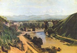
- Gallery at Furlo PassFurlo Passthumb|240px|Entrance of the Roman tunnel.The Furlo Pass is a gorge on the ancient Roman road Via Flaminia in the Marche region of central Italy, where it passes near the Candigliano river, an affluence of the Metauro.The gorge was formed between the Pietralata and Paganuccio Mounts by the waters...
Other notable Roman vestiges along the road, aside from those within the individual towns, include a pair of tower tombs between Bevagna and Foligno; and along the eastern branch of the Flaminia in particular, in the area between Spoleto and Trevi
Trevi
Trevi is an ancient town and comune in Umbria, Italy, on the lower flank of Monte Serano overlooking the wide plain of the Clitunno river system. It is 10 km SSE of Foligno and 20 km north of Spoleto....
, many small Romanesque churches, partly built of reused Roman stone (spolia
Spolia
Spolia is a modern art-historical term used to describe the re-use of earlier building material or decorative sculpture on new monuments...
) — including a few inscriptions — mark the straight line of the road quite clearly. A small stretch of the road remains in the ruins of Carsulae
Carsulae
Carsulae is an archaeological site in Umbria, central Italy, now one of the most important archaeological ruins in Italy. It is located c. 4 km north of San Gemini, a small comune in the province of Terni. Nearby is the comune of Montecastrilli .-Origins and history:Most historians fix the...
where it passes through the impressive Arco di Traiano.
Sport
The road was used as part of the individual road race cyclingCycling at the 1960 Summer Olympics
The cycling competition at the 1960 Summer Olympics consisted of two road cycling events and four track cycling events, all for men only.-Medal table:-Medal summary:-References:*...
event for the 1960 Summer Olympics
1960 Summer Olympics
The 1960 Summer Olympics, officially known as the Games of the XVII Olympiad, was an international multi-sport event held from August 25 to September 11, 1960 in Rome, Italy...
in Rome
Rome
Rome is the capital of Italy and the country's largest and most populated city and comune, with over 2.7 million residents in . The city is located in the central-western portion of the Italian Peninsula, on the Tiber River within the Lazio region of Italy.Rome's history spans two and a half...
.
See also
- Roman roadRoman roadThe Roman roads were a vital part of the development of the Roman state, from about 500 BC through the expansion during the Roman Republic and the Roman Empire. Roman roads enabled the Romans to move armies and trade goods and to communicate. The Roman road system spanned more than 400,000 km...
- Roman bridgeRoman bridgeRoman bridges, built by ancient Romans, were the first large and lasting bridges built. Roman bridges were built with stone and had the arch as its basic structure....
- Roman engineeringRoman engineeringRomans are famous for their advanced engineering accomplishments, although some of their own inventions were improvements on older ideas, concepts and inventions. Technology for bringing running water into cities was developed in the east, but transformed by the Romans into a technology...
- Via del CorsoVia del CorsoThe Via del Corso , commonly known as the Corso, is a main street in the historical centre of Rome. It is remarkable for being absolutely straight in an area characterized by narrow meandering alleys and small piazzas...
- Via LataVia LataVia Lata may mean one of two ancient Roman roads:*The Via Lata , now known as the Via del Corso, another name for the Via Flaminia once it has entered the city through the Porta del Popolo, in Rome....
- Piazza del PopoloPiazza del PopoloPiazza del Popolo is a large urban square in Rome. The name in modern Italian literally means "People's Square", but historically it derives from the poplars after which the church of Santa Maria del Popolo, in the northeast corner of the piazza, takes its name.The piazza lies inside the northern...
External links
- 1960 Summer Olympics official report. Volume 1. p. 84.
- 1960 Summer Olympics official report. Volume 2, Part 1. p. 319.
- The Via Flaminia at LacusCurtius
- Omnes Viae: Via Flaminia on the Peutinger Map