

Scott County, Kansas
Encyclopedia
Scott County is a county located in the U.S. state
of Kansas
. As of the 2010 census, the county population was 4,936. Its county seat
is Scott City
, the only city in the county.
, county. Alcohol is only sold in liquor stores, with 3.2% cereal-malt beverages available in grocery stores.
of 2000, there were 5,120 people, 2,045 households, and 1,435 families residing in the county. The population density
was 7 people per square mile (3/km²). There were 2,291 housing units at an average density of 3 per square mile (1/km²). The racial makeup of the county was 95.47% White
, 0.10% Black
or African American
, 0.55% Native American
, 0.12% Asian
, 2.75% from other races
, and 1.02% from two or more races. 6.31% of the population were Hispanic
or Latino
of any race.
There were 2,045 households out of which 33.30% had children under the age of 18 living with them, 61.00% were married couples
living together, 6.70% had a female householder with no husband present, and 29.80% were non-families. 27.30% of all households were made up of individuals and 13.60% had someone living alone who was 65 years of age or older. The average household size was 2.46 and the average family size was 3.01.
In the county the population was spread out with 27.10% under the age of 18, 6.60% from 18 to 24, 25.30% from 25 to 44, 24.40% from 45 to 64, and 16.50% who were 65 years of age or older. The median age was 39 years. For every 100 females there were 97.10 males. For every 100 females age 18 and over, there were 94.40 males.
The median income for a household in the county was $40,534, and the median income for a family was $50,549. Males had a median income of $32,166 versus $20,221 for females. The per capita income
for the county was $20,443. About 2.10% of families and 5.10% of the population were below the poverty line, including 6.00% of those under age 18 and 8.10% of those age 65 or over.
. Scott City
is considered governmentally independent and is excluded from the census figures for the townships. In the following table, the population center is the largest city (or cities) included in that township's population total, if it is of a significant size.
Other County Websites
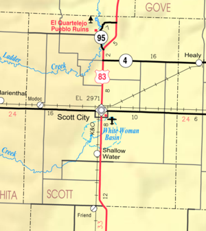
Maps
U.S. state
A U.S. state is any one of the 50 federated states of the United States of America that share sovereignty with the federal government. Because of this shared sovereignty, an American is a citizen both of the federal entity and of his or her state of domicile. Four states use the official title of...
of Kansas
Kansas
Kansas is a US state located in the Midwestern United States. It is named after the Kansas River which flows through it, which in turn was named after the Kansa Native American tribe, which inhabited the area. The tribe's name is often said to mean "people of the wind" or "people of the south...
. As of the 2010 census, the county population was 4,936. Its county seat
County seat
A county seat is an administrative center, or seat of government, for a county or civil parish. The term is primarily used in the United States....
is Scott City
Scott City, Kansas
Scott City is a city in and the county seat of Scott County, Kansas, United States. As of the 2010 census, the city population was 3,816.-Geography:Scott City is located at...
, the only city in the county.
Law and government
Although the Kansas Constitution was amended in 1986 to allow the sale of alcoholic liquor by the individual drink with the approval of voters, Scott County has remained a prohibition, or "dry"Dry county
A dry county is a county in the United States whose government forbids the sale of alcoholic beverages. Some prohibit off-premises sale, some prohibit on-premises sale, and some prohibit both. Hundreds of dry counties exist across the United States, almost all of them in the South...
, county. Alcohol is only sold in liquor stores, with 3.2% cereal-malt beverages available in grocery stores.
Geography
According to the 2000 census, the county has a total area of 717.64 square miles (1,858.7 km²), of which 717.52 square miles (1,858.4 km²) (or 99.98%) is land and 0.12 square mile (0.3107985732 km²) (or 0.02%) is water.Adjacent counties
- Gove CountyGove County, KansasGove County is a county located in Northwest Kansas, in the Central United States. As of the 2010 census, the county population was 2,695...
(northeast) - Lane CountyLane County, KansasLane County is a county located in the U.S. state of Kansas. As of the 2010 census, the county population was 1,750. The county seat is Dighton, the only city in the county. Lane County was named after James H. Lane who was a leader of the Jayhawker abolitionist movement and served as one of...
(east) - Finney CountyFinney County, KansasFinney County is a county located in Southwest Kansas, in the Central United States. As of the 2010 census, the county population was 36,776. Its county seat and most populous city is Garden City...
(south) - Kearny CountyKearny County, KansasKearny County is a county located in Southwest Kansas, in the Central United States. As of the 2010 census, the county population was 3,977. Its county seat and most populous city is Lakin...
(southwest) - Wichita CountyWichita County, KansasWichita County is a county located in the U.S. state of Kansas. As of the 2010 census, the county population was 2,234...
(west) - Logan CountyLogan County, KansasLogan County is a county located in the U.S. state of Kansas. As of the 2010 census, the county population was 2,756...
(northwest)
Demographics
As of the censusCensus
A census is the procedure of systematically acquiring and recording information about the members of a given population. It is a regularly occurring and official count of a particular population. The term is used mostly in connection with national population and housing censuses; other common...
of 2000, there were 5,120 people, 2,045 households, and 1,435 families residing in the county. The population density
Population density
Population density is a measurement of population per unit area or unit volume. It is frequently applied to living organisms, and particularly to humans...
was 7 people per square mile (3/km²). There were 2,291 housing units at an average density of 3 per square mile (1/km²). The racial makeup of the county was 95.47% White
Race (United States Census)
Race and ethnicity in the United States Census, as defined by the Federal Office of Management and Budget and the United States Census Bureau, are self-identification data items in which residents choose the race or races with which they most closely identify, and indicate whether or not they are...
, 0.10% Black
Race (United States Census)
Race and ethnicity in the United States Census, as defined by the Federal Office of Management and Budget and the United States Census Bureau, are self-identification data items in which residents choose the race or races with which they most closely identify, and indicate whether or not they are...
or African American
Race (United States Census)
Race and ethnicity in the United States Census, as defined by the Federal Office of Management and Budget and the United States Census Bureau, are self-identification data items in which residents choose the race or races with which they most closely identify, and indicate whether or not they are...
, 0.55% Native American
Race (United States Census)
Race and ethnicity in the United States Census, as defined by the Federal Office of Management and Budget and the United States Census Bureau, are self-identification data items in which residents choose the race or races with which they most closely identify, and indicate whether or not they are...
, 0.12% Asian
Race (United States Census)
Race and ethnicity in the United States Census, as defined by the Federal Office of Management and Budget and the United States Census Bureau, are self-identification data items in which residents choose the race or races with which they most closely identify, and indicate whether or not they are...
, 2.75% from other races
Race (United States Census)
Race and ethnicity in the United States Census, as defined by the Federal Office of Management and Budget and the United States Census Bureau, are self-identification data items in which residents choose the race or races with which they most closely identify, and indicate whether or not they are...
, and 1.02% from two or more races. 6.31% of the population were Hispanic
Race (United States Census)
Race and ethnicity in the United States Census, as defined by the Federal Office of Management and Budget and the United States Census Bureau, are self-identification data items in which residents choose the race or races with which they most closely identify, and indicate whether or not they are...
or Latino
Race (United States Census)
Race and ethnicity in the United States Census, as defined by the Federal Office of Management and Budget and the United States Census Bureau, are self-identification data items in which residents choose the race or races with which they most closely identify, and indicate whether or not they are...
of any race.
There were 2,045 households out of which 33.30% had children under the age of 18 living with them, 61.00% were married couples
Marriage
Marriage is a social union or legal contract between people that creates kinship. It is an institution in which interpersonal relationships, usually intimate and sexual, are acknowledged in a variety of ways, depending on the culture or subculture in which it is found...
living together, 6.70% had a female householder with no husband present, and 29.80% were non-families. 27.30% of all households were made up of individuals and 13.60% had someone living alone who was 65 years of age or older. The average household size was 2.46 and the average family size was 3.01.
In the county the population was spread out with 27.10% under the age of 18, 6.60% from 18 to 24, 25.30% from 25 to 44, 24.40% from 45 to 64, and 16.50% who were 65 years of age or older. The median age was 39 years. For every 100 females there were 97.10 males. For every 100 females age 18 and over, there were 94.40 males.
The median income for a household in the county was $40,534, and the median income for a family was $50,549. Males had a median income of $32,166 versus $20,221 for females. The per capita income
Per capita income
Per capita income or income per person is a measure of mean income within an economic aggregate, such as a country or city. It is calculated by taking a measure of all sources of income in the aggregate and dividing it by the total population...
for the county was $20,443. About 2.10% of families and 5.10% of the population were below the poverty line, including 6.00% of those under age 18 and 8.10% of those age 65 or over.
Incorporated cities
Name and population (2004 estimate):- Scott CityScott City, KansasScott City is a city in and the county seat of Scott County, Kansas, United States. As of the 2010 census, the city population was 3,816.-Geography:Scott City is located at...
, 3,545 (county seat)
Unincorporated places
- Chevron
- Grigston
- Hutchins
- ManningManning, KansasManning is a small unincorporated community in Scott County, Kansas, United States. Its post office was established December 20, 1887, and closed June 30, 1955....
- ModocModoc, KansasModoc is a small unincorporated community in Scott County, Kansas, United States. Its post office was established October 10, 1887, and closed March 21, 1992....
- PencePence, KansasPence is a small unincorporated community in Scott County, Kansas, United States. Its post office was established June 21, 1887, and closed August 31, 1920....
- Shallow WaterShallow Water, KansasShallow Water is a small unincorporated community in Scott County, Kansas, United States. Its post office was established January 13, 1913, and closed October 31, 1957. Shallow Water is the northern terminus of the Garden City Western Railway....
- Tractor
Townships
Scott County is divided into seven townshipsCivil township
A civil township is a widely used unit of local government in the United States, subordinate to, and geographic divisions of, a county. Specific responsibilities and the degree of autonomy vary based on each state. Civil townships are distinct from survey townships, but in states that have both,...
. Scott City
Scott City, Kansas
Scott City is a city in and the county seat of Scott County, Kansas, United States. As of the 2010 census, the city population was 3,816.-Geography:Scott City is located at...
is considered governmentally independent and is excluded from the census figures for the townships. In the following table, the population center is the largest city (or cities) included in that township's population total, if it is of a significant size.
| Township | FIPS | Population center |
Population | Population density /km² (/sq mi) |
Land area km² (sq mi) | Water area km² (sq mi) | Water % | Geographic coordinates |
|---|---|---|---|---|---|---|---|---|
| Beaver | 05175 | 302 | 1 (3) | 309 (119) | 0 (0) | 0.10% | 38°37′11"N 100°59′58"W | |
| Isbel | 34575 | 110 | 1 (1) | 206 (80) | 0 (0) | 0 % | 38°28′52"N 101°2′52"W | |
| Keystone | 36600 | 106 | 1 (1) | 206 (80) | 0 (0) | 0 % | 38°30′17"N 100°45′4"W | |
| Lake | 37850 | 95 | 0 (1) | 311 (120) | 0 (0) | 0 % | 38°20′23"N 100°49′39"W | |
| Michigan | 46175 | 88 | 0 (1) | 308 (119) | 0 (0) | 0 % | 38°36′23"N 100°48′23"W | |
| Scott | 63575 | 309 | 2 (4) | 202 (78) | 0 (0) | 0 % | 38°29′31"N 100°55′0"W | |
| Valley | 73125 | 255 | 1 (2) | 311 (120) | 0 (0) | 0 % | 38°21′6"N 100°58′13"W |
Education
Public Library
The Scott County Public Library is located at 110 West 8th in Scott City. The Scott County Library was the first free county public library in the state of Kansas. It was started in September 1923 with the five members of the library committee each checking out a book for herself and one for her husband thus the library checked out ten books on the first day that it was open. Two rooms on the second floor of the Cretcher Lumber Company office building were made available for the library. L. W. Cretcher, owner of the lumber yard, gave the library a boost by painting the rooms, furnishing a stove, shelves, cupboards, lights, and free rent. In November 1924 a proposal was placed on the ballot for the library to be a county funded entity. A room was set aside in the basement of the newly built courthouse for the library, which at that time possessed 861 books. The library in the courthouse was opened to the public in July 1925. The library remained in the basement of the Scott County Courthouse until a separate library building was constructed at 110 West 8th Street in 1964. This building was 4150 square feet (385.5 m²) with a 660 square feet (61.3 m²) meeting room available to the public. In 2004, the Scott County Library Board began a fundraising effort for a Library Building expansion of 7350 feet (2,240.3 m). The Library expansion and remodel to 12160 square feet (1,129.7 m²) was completed in May 2009.Further reading
- History of the State of Kansas; William G. Cutler; A.T. Andreas Publisher; 1883. (Online HTML eBook)
- Kansas : A Cyclopedia of State History, Embracing Events, Institutions, Industries, Counties, Cities, Towns, Prominent Persons, Etc; 3 Volumes; Frank W. Blackmar; Standard Publishing Co; 944 / 955 / 824 pages; 1912. (Volume1 - Download 54MB PDF eBook),(Volume2 - Download 53MB PDF eBook), (Volume3 - Download 33MB PDF eBook)
External links
OfficialOther County Websites
Maps
- Scott County Map, KDOT
- Kansas Highway Map, KDOT
- Kansas Railroad Map, KDOT
- Kansas School District Boundary Map, KSDE