
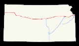
Interstate 70 in Kansas
Encyclopedia
In the U.S. state
of Kansas
, Interstate 70
contains the first segment to start being paved and to be completed in the Interstate Highway System. It extends from the Western border to the Eastern border covering 424 miles (682.4 km) and passing through several of the state's principal cities in the process.
 I-70 is joined with US-24 from the Colorado state line until US-24 splits at Levant
and runs north of I-70. At Colby
, I-70 begins to turn southeast until it reaches Oakley
, where US-40 joins with I-70 for a concurrent journey through most of the state. The route remains flat until it reaches the county line between Russell
and Ellsworth
counties, where the road begins to travese rolling hills.
At Salina
, Interstate 135 begins its journey southward toward Wichita
, and I-70 continues through Abilene
and Junction City
, where the road begins to run through the Flint Hills
.
In Topeka
, I-70 intersects a child route, I-470
, twice. The second time it is intersected, the Kansas Turnpike
merges, making I-70 into a toll road
. This is one of only two sections of I-70 that are tolled (the other is along the Pennsylvania Turnpike
). I-70 carries this designation from Topeka to Bonner Springs
. It is the eastern terminus of the turnpike, and from there to 18th Street and extending on to the Kansas eastern border, the highway is free.
I-70 enters Missouri via a main northern route on the Lewis and Clark Viaduct above the confluence of the Kansas River
and Missouri River
and a route designated "Alternate I-70" which has signs for I-70 as well as Interstate 670 just south of Kansas City main downtown area.
The southern route is called the Jay B. Dillingham
Memorial Highway after the former Kansas City Stockyards
chairman.
was finished by 1956 and opened to traffic. West of Topeka, the freeway was constructed from Topeka west to Salina
at its junction with U.S. Route 81, as well as from Ogallah
to Grainfield
. From Salina, the freeway was completed through Wilson
the next year. A segment of I-70 from Levant
through Ogallah was finished by 1965. Another section was built the following year connecting Wilson to Grainfield. The freeway was completed through Kansas with a last section near the Colorado
border in 1970.
and use its mileposts instead.
around mile 230 on Interstate 70, near Ellsworth
U.S. state
A U.S. state is any one of the 50 federated states of the United States of America that share sovereignty with the federal government. Because of this shared sovereignty, an American is a citizen both of the federal entity and of his or her state of domicile. Four states use the official title of...
of Kansas
Kansas
Kansas is a US state located in the Midwestern United States. It is named after the Kansas River which flows through it, which in turn was named after the Kansa Native American tribe, which inhabited the area. The tribe's name is often said to mean "people of the wind" or "people of the south...
, Interstate 70
Interstate 70
Interstate 70 is an Interstate Highway in the United States that runs from Interstate 15 near Cove Fort, Utah, to a Park and Ride near Baltimore, Maryland. It was the first Interstate Highway project in the United States. I-70 approximately traces the path of U.S. Route 40 east of the Rocky...
contains the first segment to start being paved and to be completed in the Interstate Highway System. It extends from the Western border to the Eastern border covering 424 miles (682.4 km) and passing through several of the state's principal cities in the process.
Route description
Levant, Kansas
Levant is an unincorporated community in Thomas County, Kansas, United States. Levant is west of Colby. Levant has a post office with ZIP code 67743....
and runs north of I-70. At Colby
Colby, Kansas
Colby is a city in and the county seat of Thomas County, Kansas, United States. As of the 2010 census, the city population was 5,387.-History:...
, I-70 begins to turn southeast until it reaches Oakley
Oakley, Kansas
Oakley is a city in Gove, Logan, and Thomas counties in the U.S. state of Kansas. As of the 2010 census, the city population was 2,045. It is the county seat of Logan County.-Geography:...
, where US-40 joins with I-70 for a concurrent journey through most of the state. The route remains flat until it reaches the county line between Russell
Russell County, Kansas
Russell County is a county located in the U.S. state of Kansas. The county's population was 6,970 for the 2010 census...
and Ellsworth
Ellsworth County, Kansas
Ellsworth County is a county located in Central Kansas, in the Central United States. As of the 2010 census, the county population was 6,497. Its county seat and most populous city is Ellsworth.-19th century:...
counties, where the road begins to travese rolling hills.
At Salina
Salina, Kansas
Salina is a city in and the county seat of Saline County, Kansas, United States. As of the 2010 census, the city population was 47,707. Located in one of the world's largest wheat-producing areas, Salina is a regional trade center for north-central Kansas...
, Interstate 135 begins its journey southward toward Wichita
Wichita, Kansas
Wichita is the largest city in the U.S. state of Kansas.As of the 2010 census, the city population was 382,368. Located in south-central Kansas on the Arkansas River, Wichita is the county seat of Sedgwick County and the principal city of the Wichita metropolitan area...
, and I-70 continues through Abilene
Abilene, Kansas
Abilene is a city in and the county seat of Dickinson County, Kansas, United States. As of the 2010 census, the city population was 6,844.-History:...
and Junction City
Junction City, Kansas
Junction City is a city in and the county seat of Geary County, Kansas, United States. As of the 2010 census, the city population was 23,353. Fort Riley, a major U.S. Army post, is nearby...
, where the road begins to run through the Flint Hills
Flint Hills
The Flint Hills, historically known as Bluestem Pastures or Blue Stem Hills, are a band of hills in eastern Kansas stretching into north-central Oklahoma, extending from Marshall County, Kansas and Washington County, Kansas in the north to Cowley County, Kansas and Osage County, Oklahoma in the south...
.
In Topeka
Topeka, Kansas
Topeka |Kansa]]: Tó Pee Kuh) is the capital city of the U.S. state of Kansas and the county seat of Shawnee County. It is situated along the Kansas River in the central part of Shawnee County, located in northeast Kansas, in the Central United States. As of the 2010 census, the city population was...
, I-70 intersects a child route, I-470
Interstate 470 (Kansas)
Interstate 470 is a loop highway that bypasses the downtown area of Topeka, Kansas . I-470 begins at I-70 in western Topeka and heads southeast, running concurrent with U.S. Route 75 . At the I-470 junction with I-335, the freeway becomes part of the Kansas Turnpike until I-470 reaches its...
, twice. The second time it is intersected, the Kansas Turnpike
Kansas Turnpike
The Kansas Turnpike is a freeway-standard toll road that lies entirely within the U.S. state of Kansas. It runs in a general southwest-northeast direction from the Oklahoma border, and passes through several major Kansas cities, including Wichita, Topeka, Lawrence and Kansas City...
merges, making I-70 into a toll road
Toll road
A toll road is a privately or publicly built road for which a driver pays a toll for use. Structures for which tolls are charged include toll bridges and toll tunnels. Non-toll roads are financed using other sources of revenue, most typically fuel tax or general tax funds...
. This is one of only two sections of I-70 that are tolled (the other is along the Pennsylvania Turnpike
Pennsylvania Turnpike
The Pennsylvania Turnpike is a toll highway system operated by the Pennsylvania Turnpike Commission in the Commonwealth of Pennsylvania, United States. The three sections of the turnpike system total . The main section extends from Ohio to New Jersey and is long...
). I-70 carries this designation from Topeka to Bonner Springs
Bonner Springs, Kansas
Bonner Springs is a river city in Johnson, Leavenworth, and Wyandotte counties in the U.S. state of Kansas. It is a suburb in the Kansas City, Missouri Metropolitan Area. The vast majority of the city, which lies in Wyandotte County, is part of the "Unified Government" which contains Kansas City,...
. It is the eastern terminus of the turnpike, and from there to 18th Street and extending on to the Kansas eastern border, the highway is free.
I-70 enters Missouri via a main northern route on the Lewis and Clark Viaduct above the confluence of the Kansas River
Kansas River
The Kansas River is a river in northeastern Kansas in the United States. It is the southwestern-most part of the Missouri River drainage, which is in turn the northwestern-most portion of the extensive Mississippi River drainage. Its name come from the Kanza people who once inhabited the area...
and Missouri River
Missouri River
The Missouri River flows through the central United States, and is a tributary of the Mississippi River. It is the longest river in North America and drains the third largest area, though only the thirteenth largest by discharge. The Missouri's watershed encompasses most of the American Great...
and a route designated "Alternate I-70" which has signs for I-70 as well as Interstate 670 just south of Kansas City main downtown area.
The southern route is called the Jay B. Dillingham
Jay B. Dillingham
Jay B. Dillingham was a former president of the Kansas City Stockyards as well as former president of the Chamber of Commerce for both Kansas City, Missouri and Kansas City, Kansas.Dillingham was born in Platte City, Missouri...
Memorial Highway after the former Kansas City Stockyards
Kansas City Stockyards
The Kansas City Stockyards in the West Bottoms west of downtown Kansas City, Missouri flourished from 1871 until closing in 1991.Jay B. Dillingham was the President of the stockyards from the 1948 to its closing in 1991.-History:...
chairman.
History
The section of I-70 that is now the Kansas TurnpikeKansas Turnpike
The Kansas Turnpike is a freeway-standard toll road that lies entirely within the U.S. state of Kansas. It runs in a general southwest-northeast direction from the Oklahoma border, and passes through several major Kansas cities, including Wichita, Topeka, Lawrence and Kansas City...
was finished by 1956 and opened to traffic. West of Topeka, the freeway was constructed from Topeka west to Salina
Salina, Kansas
Salina is a city in and the county seat of Saline County, Kansas, United States. As of the 2010 census, the city population was 47,707. Located in one of the world's largest wheat-producing areas, Salina is a regional trade center for north-central Kansas...
at its junction with U.S. Route 81, as well as from Ogallah
Ogallah, Kansas
Ogallah is a community in Trego County, Kansas. The post office was established January 27, 1897....
to Grainfield
Grainfield, Kansas
Grainfield is a city in Gove County, Kansas, United States. As of the 2010 census, the city population was 277.-Geography:Grainfield is located at . According to the United States Census Bureau, the city has a total area of , all of it land.-Demographics:As of the census of 2 there were 327...
. From Salina, the freeway was completed through Wilson
Wilson, Kansas
Wilson is a city in Ellsworth County, Kansas, United States. As of the 2010 census, the city population was 781.-History:The Butterfield Overland Despatch built a stagecoach station one-half mile south of present-day Wilson in 1865. Three years later, the Kansas Pacific Railway built Wilson...
the next year. A segment of I-70 from Levant
Levant, Kansas
Levant is an unincorporated community in Thomas County, Kansas, United States. Levant is west of Colby. Levant has a post office with ZIP code 67743....
through Ogallah was finished by 1965. Another section was built the following year connecting Wilson to Grainfield. The freeway was completed through Kansas with a last section near the Colorado
Colorado
Colorado is a U.S. state that encompasses much of the Rocky Mountains as well as the northeastern portion of the Colorado Plateau and the western edge of the Great Plains...
border in 1970.
Exit list
Exit numbers correspond to the mileposts where they're located (numbered from west to east), except at exits 366, 371, 377, and 407, which are part of the Kansas TurnpikeKansas Turnpike
The Kansas Turnpike is a freeway-standard toll road that lies entirely within the U.S. state of Kansas. It runs in a general southwest-northeast direction from the Oklahoma border, and passes through several major Kansas cities, including Wichita, Topeka, Lawrence and Kansas City...
and use its mileposts instead.
| County | Location | Mile | # Exit number An exit number is a number assigned to a road junction, usually an exit from a freeway. It is usually marked on the same sign as the destinations of the exit, as well as a sign in the gore.... |
Destinations | Notes | |
|---|---|---|---|---|---|---|
| Sherman Sherman County, Kansas Sherman County is a county located in the U.S. state of Kansas. As of the 2010 census, the county population was 6,010... |
1 | |||||
| 9 | County Road 11 | |||||
| 12 | County Road 14 | |||||
| Goodland Goodland, Kansas Goodland is a city in and the county seat of Sherman County, Kansas, United States. As of the 2010 census, the city population was 4,489.-History:... |
17 | |||||
| 19 | ||||||
| 27 | ||||||
| Thomas Thomas County, Kansas Thomas County is a county located in the U.S. state of Kansas. As of the 2010 census, the county population was 7,900... |
36 | |||||
| 45 | East end of US-24 overlap | |||||
| Colby Colby, Kansas Colby is a city in and the county seat of Thomas County, Kansas, United States. As of the 2010 census, the city population was 5,387.-History:... |
53 | |||||
| 54 | Country Club Drive | |||||
| 62 | County Road K | |||||
| 70 | ||||||
| Logan Logan County, Kansas Logan County is a county located in the U.S. state of Kansas. As of the 2010 census, the county population was 2,756... |
No interchanges in Logan County | |||||
| Gove Gove County, Kansas Gove County is a county located in Northwest Kansas, in the Central United States. As of the 2010 census, the county population was 2,695... |
76 | West end of US-40 overlap | ||||
| 79 | Campus Road | Near Campus | ||||
| 85 | ||||||
| 93 | ||||||
| 95 | ||||||
| 99 | ||||||
| Quinter Quinter, Kansas Quinter is a city in Gove County, Kansas, United States. As of the 2010 census, the city population was 918.-History:The city of Quinter is built at the location of an old railroad switching site called Melota. A town named Familton was built there in 1885, consisting originally of a two-story... |
107 | |||||
| Trego Trego County, Kansas Trego County is a county located in the U.S. state of Kansas. As of the 2010 census, the county population was 3,001... |
115 | |||||
| 120 | Voda Road | |||||
| WaKeeney WaKeeney, Kansas WaKeeney is a city in and the county seat of Trego County, Kansas, United States. As of the 2010 census, the city population was 1,862.-History:... |
127 | No access to 283 north from 70/40 west; no access to 70/40 east from 283 south | ||||
| 128 | ||||||
| 135 | ||||||
| 140 | Riga Road | |||||
| Ellis Ellis County, Kansas Ellis County is a county located in Northwest Kansas, in the Central United States. As of the 2010 census, the county population was 28,452. Its county seat and most populous city is Hays... |
Ellis Ellis, Kansas Ellis is a city in Ellis County, Kansas, United States. As of the 2010 census, the city population was 2,062.- History :The Kansas Pacific Railway built a water station at the site of present-day Ellis in 1867 and then purchased the site under the Homestead Act. Three years later, in 1870, the U.S.... |
145 | ||||
| 153 | Yocemento Avenue | |||||
| Hays Hays, Kansas Hays is a city in and the county seat of Ellis County, Kansas, United States. The largest city in northwestern Kansas, it is the economic and cultural center of the region. It is also a college town, home to Fort Hays State University... |
157 | |||||
| 159 | ||||||
| 161 | Commerce Parkway | |||||
| 163 | Toulon Avenue | |||||
| 168 | ||||||
| 172 | Walker Avenue | |||||
| Russell Russell County, Kansas Russell County is a county located in the U.S. state of Kansas. The county's population was 6,970 for the 2010 census... |
175 | Gorham Gorham, Kansas Gorham is a city in Russell County, Kansas, United States. As of the 2010 census, the city population was 334.-History:Beaten to the settlement of Wilson, Kansas by Bohemian colonists, German settlers from Philadelphia and Lancaster, Pennsylvania established a community on the Kansas Pacific... |
Former K-257 K-257 (Kansas highway) K-257 was a state highway in the U.S. state of Kansas that ran approximately north–south in the west central part of the state.K-257 has its northern terminus at Gorham at the former U.S. Route 40. Its southern terminus is at Interstate 70 approximately one mile south of Gorham.It was given... |
|||
| 180 | Balta Road | |||||
| Russell Russell, Kansas Russell is the most populous city in and county seat of Russell County, Kansas, United States. As of the 2010 census, the city population was 4,506.-History:... |
184 | |||||
| 189 | ||||||
| 193 | Bunker Hill Road | |||||
| Dorrance Dorrance, Kansas Dorrance is a city in Russell County, Kansas, United States. As of the 2010 census, the city population was 185.-History:The Kansas Pacific Railway reached the site of Dorrance in June 1867. German, English, and Irish settlers followed shortly thereafter, forming a small community by 1870. In early... |
199 | Dorrance Dorrance, Kansas Dorrance is a city in Russell County, Kansas, United States. As of the 2010 census, the city population was 185.-History:The Kansas Pacific Railway reached the site of Dorrance in June 1867. German, English, and Irish settlers followed shortly thereafter, forming a small community by 1870. In early... |
Former K-231 | |||
| Ellsworth Ellsworth County, Kansas Ellsworth County is a county located in Central Kansas, in the Central United States. As of the 2010 census, the county population was 6,497. Its county seat and most populous city is Ellsworth.-19th century:... |
206 | |||||
| 209 | Sylvan Grove Sylvan Grove, Kansas Sylvan Grove is a city in Lincoln County, Kansas, United States. As of the 2010 census, the city population was 279.-Geography:Sylvan Grove is located at... |
|||||
| 216 | Vesper | |||||
| 219 | West end of K-14 overlap | |||||
| 221 | East end of K-14 overlap | |||||
| 225 | ||||||
| Lincoln Lincoln County, Kansas Lincoln County is a county located in the U.S. state of Kansas. As of the 2010 census, the county population was 3,241... |
233 | Beverly Beverly, Kansas Beverly is a city in Lincoln County, Kansas, United States. As of the 2010 census, the city population was 162.-Geography:Beverly is located at . According to the United States Census Bureau, the city has a total area of , all of it land.-Demographics:As of the census of 2000, there were 199... , Carneiro |
||||
| Saline Saline County, Kansas Saline County is a county located in the U.S. state of Kansas. As of the 2010 census, the county population was 55,606... |
238 | Brookville Brookville, Kansas Brookville is a city in Saline County, Kansas, United States. As of the 2010 census, the city population was 262. The population was higher in the turn of the 20th century and the city featured the Brookville Hotel. It is part of the Salina Micropolitan Statistical Area.-Geography:Brookville is... , Tescott Tescott, Kansas Tescott is a city in Ottawa County, Kansas, United States. As of the 2010 census, the city population was 319. It is part of the Salina Micropolitan Statistical Area.-Geography:Tescott is located at... |
||||
| 244 | Hedville Hedville, Kansas Hedville is an unincorporated community in northern Ohio Township, Saline County, Kansas, United States. It lies along Hedville Road and a Kansas and Oklahoma Railroad line, south of Interstate 70, northwest of the city of Salina, the county seat of Saline County. Mulberry Creek flows through... , Culver Culver, Kansas Culver is a city in Ottawa County, Kansas, United States. As of the 2010 census, the city population was 121. It is part of the Salina Micropolitan Statistical Area.-Geography:Culver is located at... |
|||||
| 249 | Halstead Road | |||||
| 250 | Signed as exits 250A (south) and 250B (north) | |||||
| Salina Salina, Kansas Salina is a city in and the county seat of Saline County, Kansas, United States. As of the 2010 census, the city population was 47,707. Located in one of the world's largest wheat-producing areas, Salina is a regional trade center for north-central Kansas... |
251 | |||||
| 253 | Ohio Street | |||||
| 260 | Niles Road | |||||
| Dickinson Dickinson County, Kansas Dickinson County is a county located in Central Kansas, in the Central United States. As of the 2010 census, the county population was 19,754. Its county seat and most populous city is Abilene. It was named in honor of Daniel S. Dickinson.-19th century:In 1887, Mr. Herington successfully got... |
Solomon Solomon, Kansas Solomon is a city in Dickinson and Saline counties in the U.S. state of Kansas. As of the 2010 census, the city population was 1,095. The Saline County portion of Solomon is part of the Salina Micropolitan Statistical Area.-Geography:... |
266 | ||||
| 272 | Fair Road | |||||
| Abilene Abilene, Kansas Abilene is a city in and the county seat of Dickinson County, Kansas, United States. As of the 2010 census, the city population was 6,844.-History:... |
275 | Eisenhower ("father" of the Interstate Highway) Center | ||||
| 277 | Jeep Road | |||||
| 281 | ||||||
| 286 | ||||||
| Geary Geary County, Kansas Geary County is a county located in Northeast Kansas, in the Central United States. As of the 2010 census, the county population was 34,362. Its county seat and most populous city is Junction City. The county is named in honor of Governor John W. Geary... |
290 | Milford Lake Road | ||||
| Junction City Junction City, Kansas Junction City is a city in and the county seat of Geary County, Kansas, United States. As of the 2010 census, the city population was 23,353. Fort Riley, a major U.S. Army post, is nearby... |
295 | West end of K-18 overlap | ||||
| 296 | ||||||
| 298 | East Street, Chestnut Street | |||||
| Grandview Plaza Grandview Plaza, Kansas Grandview Plaza is a city in Geary County, Kansas, United States. As of the 2010 census, the city population was 1,560. It is part of the Manhattan, Kansas Metropolitan Statistical Area.-Geography:Grandview Plaza is located at... |
299 | J Hill Road, Flinthills Boulevard (US-40 Bus.) | ||||
| 300 | No westbound entrance | |||||
| 301 | Fort Riley Fort Riley Fort Riley is a United States Army installation located in Northeast Kansas, on the Kansas River, between Junction City and Manhattan. The Fort Riley Military Reservation covers 100,656 acres in Geary and Riley counties and includes two census-designated places: Fort Riley North and Fort... , Marshall Field Marshall Army Airfield Marshall Army Airfield is a military airfield located on Fort Riley, Kansas. It was opened in 1921. The primary mission for MAAF is to provide fully integrated fixed base helicopter operations for the Combat Aviation Brigade.... |
|||||
| 303 | East end of K-18 overlap | |||||
| 304 | Humboldt Creek Road | |||||
| 307 | McDowell Creek Road | |||||
| 311 | Moritz Road | |||||
| 313 | ||||||
| Riley Riley County, Kansas Riley County is a county located in the U.S. state of Kansas. The county's population was 71,115 for the 2010 census. The largest city and county seat is Manhattan. The county is part of the Manhattan, Kansas, Metropolitan Statistical Area.Riley County is home to two of Kansas' largest... |
316 | Deep Creek Road | ||||
| 318 | Frontage Road | |||||
| Wabaunsee Wabaunsee County, Kansas Wabaunsee County is a county located in the U.S. state of Kansas. As of the 2010 census, the county population was 7,053. Its county seat is Alma. It is part of the Topeka, Kansas Metropolitan Statistical Area... |
322 | Tallgrass Road | ||||
| 324 | Wabaunsee Road | |||||
| 328 | ||||||
| 330 | ||||||
| 332 | Spring Creek Road | |||||
| 333 | ||||||
| 335 | Snokomo Road | |||||
| 338 | Vera Road | |||||
| 341 | ||||||
| 342 | Keene-Eskridge Road | |||||
| 343 | Ranch Road | Private Interchange for Hudson Ranch | ||||
| Shawnee Shawnee County, Kansas Shawnee County is a county located in northeast Kansas, in the central United States of America. Its most populous city, Topeka, is the state capital and county seat. The county's population was 177,934 for the 2010 census... |
346 | Carlson Road | ||||
| 347 | West Union Road | |||||
| 350 | Valencia Road | |||||
| 351 | Frontage Road | Eastbound exit and westbound entrance | ||||
| 353 | West end of K-4 overlap | |||||
| Topeka Topeka, Kansas Topeka |Kansa]]: Tó Pee Kuh) is the capital city of the U.S. state of Kansas and the county seat of Shawnee County. It is situated along the Kansas River in the central part of Shawnee County, located in northeast Kansas, in the Central United States. As of the 2010 census, the city population was... |
355 | West end of US-75 overlap | ||||
| 356 | Wanamaker Road | |||||
| 357A | Fairlawn Road | Signed as exit 357 eastbound | ||||
| 357B | Danbury Lane | Westbound exit only | ||||
| 358A | East end of US-75 overlap; signed as exit 358 eastbound | |||||
| 358B | Gage Boulevard | Signed as exit 358 eastbound | ||||
| 359 | MacVicar Avenue | |||||
| 361A | 1st Avenue | Eastbound exit and westbound entrance | ||||
| 361B | 3rd Street, Monroe Street | Eastbound exit and westbound entrance | ||||
| 362A | 4th Street | Westbound exit and eastbound entrance | ||||
| 362B | 8th Avenue | Signed as exit 362 eastbound | ||||
| 362C | 10th Avenue, Madison Street | Westbound exit and eastbound entrance | ||||
| 363 | Adams Street, Branner Trafficway | |||||
| 364A | California Avenue | |||||
| 364B | Carnahan Avenue, Deer Creek Trafficway | |||||
| 365 | Rice Road | |||||
| 366 | East end of US-40 / K-4 overlap; last free exit eastbound | |||||
| West end of toll road | ||||||
| 366 | West end of KTA overlap; no exit number westbound | |||||
| Douglas Douglas County, Kansas Douglas County is a county located in northeast Kansas, in the Central United States. As of the 2010 census, the county population was 110,826... |
381 | 381 | ||||
| Lawrence Lawrence, Kansas Lawrence is the sixth largest city in the U.S. State of Kansas and the county seat of Douglas County. Located in northeastern Kansas, Lawrence is the anchor city of the Lawrence, Kansas, Metropolitan Statistical Area, which encompasses all of Douglas County... |
386 | 386 | ||||
| 388 | 388 | West end of US 24 / US 40 overlap | ||||
| Leavenworth Leavenworth County, Kansas Leavenworth County is a county located in Northeast Kansas, in the Central United States. As of the 2010 census, the county population was 76,227. Its county seat and most populous city is Leavenworth... |
No interchanges in Leavenworth County | |||||
| Wyandotte Wyandotte County, Kansas Wyandotte County is a county located in northeast Kansas, in the Central United States. The county's population was 157,505 for the 2010 census. Its county seat and most populous city is Kansas City with which it shares a unified government... |
Kansas City Kansas City, Kansas Kansas City is the third-largest city in the state of Kansas and is the county seat of Wyandotte County. It is a suburb of Kansas City, Missouri, and is the third largest city in the Kansas City Metropolitan Area. The city is part of a consolidated city-county government known as the "Unified... |
East end of toll road | ||||
| 407 | 407 | Last free exit westbound | ||||
| 410 | 110th Street | |||||
| 411 | , St. Joseph | Signed as exits 411A (south) and 411B (north) | ||||
| 414 | 78th Street | |||||
| 415 | Turner Diagnal Highway | Signed as exits 415A (east) and 415B (west) eastbound; former US 40 west, use TDH west | ||||
| 417 | 57th Street | |||||
| 418 | , St. Joseph | Signed as exits 418A (north) and 418B (south) eastbound Westbound exit is part of exit 419 |
||||
| 419 | Park Drive, 38th Street | |||||
| 420A | West end of US-69 overlap | |||||
| 420B | 18th Street north | |||||
| 421 | Railroad Yard | Westbound exit and eastbound entrance | ||||
| 421 | – St. Louis St. Louis, Missouri St. Louis is an independent city on the eastern border of Missouri, United States. With a population of 319,294, it was the 58th-largest U.S. city at the 2010 U.S. Census. The Greater St... , Wichita Wichita, Kansas Wichita is the largest city in the U.S. state of Kansas.As of the 2010 census, the city population was 382,368. Located in south-central Kansas on the Arkansas River, Wichita is the county seat of Sedgwick County and the principal city of the Wichita metropolitan area... |
Eastbound exit and westbound entrance | ||||
| 422A | East end of US-69 overlap | |||||
| 422B | West end of US-169 overlap | |||||
| 422C | Service Road | |||||
| 422D | Central Avenue | |||||
| 423A | 5th Street | Eastbound exit and westbound entrance | ||||
| 423B | James Street, 3rd Street | Eastbound exit and westbound entrance | ||||
| 423B | Washington Boulevard | Westbound exit and eastbound entrance; former US 24 west | ||||
| 423A | Fairfax District | Westbound exit and eastbound entrance | ||||
External links
- video of the Smoky Hills Wind FarmSmoky Hills Wind Farm
The Smoky Hills Wind Farm is a 100.8 megawatt wind farm in Lincoln and Ellsworth Counties, 140 miles west of Topeka in Kansas, north of Ellsworth. The farm is operated by Enel Green Power. Highway K-14 and Interstate 70 pass through parts of the wind farm, with clear views of many of the wind...
around mile 230 on Interstate 70, near Ellsworth
Ellsworth, Kansas
Ellsworth is a city in and the county seat of Ellsworth County, Kansas, United States. As of the 2010 census, the city population was 3,120.-19th century:...